Current Auction
Rare Map of Gelderland, Published in Only Two Editions
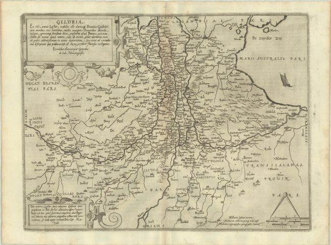
"Geldria. En Tibi, Amice Lector, Nobilis Ille Clarusq. Ducatus Geldriae...", Jode, Gerard de
Subject: Central Netherlands
Period: 1593 (published)
Publication: Speculum Orbis Terrae...
Color: Black & White
Size:
19 x 14.4 inches
48.3 x 36.6 cm
Download High Resolution Image
(or just click on image to launch the Zoom viewer)
(or just click on image to launch the Zoom viewer)
This rare map was issued in Cornelis de Jode's Speculum Orbis Terrae in 1593, which was a revised edition of an earlier atlas published by his father Gerard in 1578. Cartographically, the map is centered on the Rhine River and is oriented with north to the right. The map presents good detail of Gelderland with numerous villages and towns, rivers, roads, and topographical features depicted. The map is ornately decorated with two strapwork cartouches describing the region, distance scales with dividers, and a lone sailboat in the Zuiderzee. Latin text on verso.
De Jode's maps are often regarded as superior in both design and cartographic detail to his more successful competitor, Abraham Ortelius. There was only one edition of Cornelis' Speculum produced, making this map quite rare on the market.
References: Shirley (BL Atlases) T.JODE-1c; Van der Krogt (Vol. III) #3700:32.
Condition: B+
A crisp impression on a clean sheet with light toning along the centerfold and a pair of wormholes along the lower centerfold and top blank margin.
Estimate: $1,100 - $1,400
Price: $800
Bid Increments
$500 - $999$50
$1,000 - $2,499$100
$2,500 - $4,999$250
$5,000 - $9,999$500
Terms & Conditions