Current Auction
"Vues de Diverses Parties de la Cote Nord-Ouest d'Amerique", Vancouver, George (Capt)
Subject: California & Baja California
Period: 1799 (circa)
Publication: Voyage de Decouvertes a l'Ocean Pacifique du Nord
Color: Black & White
Size:
20.1 x 14.8 inches
51.1 x 37.6 cm
Download High Resolution Image
(or just click on image to launch the Zoom viewer)
(or just click on image to launch the Zoom viewer)
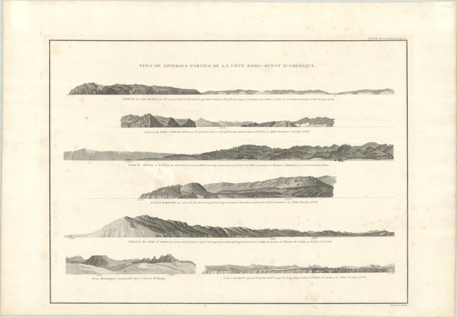
This finely engraved sheet presents a series of seven coastal profiles along the California coast, issued in a French edition of Vancouver’s Voyage of Discovery. Combining his own explorations with earlier Spanish and British discoveries, George Vancouver, who had sailed with Captain Cook on his third voyage, compiled the best delineation of the Pacific Northwest at the time. The views depict key points including Point Reyes, the entrance to San Francisco Bay, Point Pinos, Santa Barbara, San Diego, and Cape Colnett (Baja California). The profiles illustrate the varied coastal terrain from low, rolling hills to more rugged and mountainous terrain, rendered with careful attention to relief and shorelines. Each view is annotated with bearings and distances, reflecting their practical use for mariners approaching these harbors and landmarks.
References:
Condition: B
A crisp impression with some light staining and archival repairs to a 1.5" tear in a blank area between the Pointe Pinos and Santa Barbara views.
Estimate: $300 - $375
Price: $220
Bid Increments
$100 - $249$10
$250 - $499$25
$500 - $999$50
$1,000 - $2,499$100
Terms & Conditions