Current Auction
"Cote Nord-Ouest de l'Amerique Reconnue par le Cape. Vancouver 2e. Partie...", Vancouver, George (Capt)
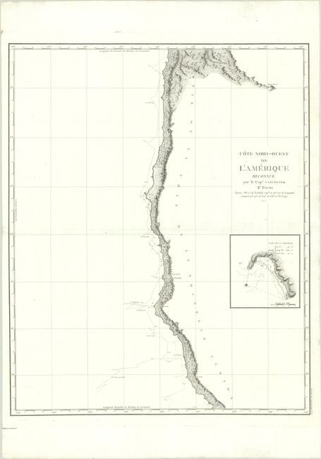
Subject: West Coast, United States
Period: 1799 (circa)
Publication: Voyage de Decouvertes a l'Ocean Pacifique du Nord
Color: Black & White
Size:
24.1 x 29.8 inches
61.2 x 75.7 cm
Download High Resolution Image
(or just click on image to launch the Zoom viewer)
(or just click on image to launch the Zoom viewer)
Beautifully engraved, large-scale map featuring the coastal topography from Point Arena to just below the mouth of the Columbia River. The track of Vancouver's exploration in 1792 is shown complete with soundings. An inset at right depicts Trinidad Bay in California. During the summers of 1792-94, George Vancouver and the crew of the British naval ships Discovery and Chatham mapped the northwest coast of North America from Baja California to Alaska. Vancouver's voyage was the last, and longest, of the great Pacific voyages of the late eighteenth century. Taking the art and technique of distant voyaging to a new level, Vancouver eliminated the possibility of a Northwest Passage and his remarkably precise surveys completed the outline of the Pacific.
See also lot 722 for Henry Wagner's The Cartography of the Northwest Coast of America to the Year 1800 that lists this map.
References: Wagner (NW) #853.
Condition: A
A crisp impression on a bright sheet with a few faint spots and one small area of paper weakness along the left border.
Estimate: $350 - $425
Price: $250
Bid Increments
$100 - $249$10
$250 - $499$25
$500 - $999$50
$1,000 - $2,499$100
Terms & Conditions