Current Auction
"[Map with Report] Great Northern Railway and Proprietary Lines [with] Eighth Annual Report of the Great Northern Railway Company", Poole Bros.

Subject: Northern United States, Railroads
Period: 1897 (published)
Publication:
Color: Printed Color
Size:
32.3 x 16.7 inches
82 x 42.4 cm
Download High Resolution Image
(or just click on image to launch the Zoom viewer)
(or just click on image to launch the Zoom viewer)
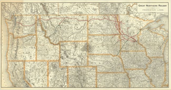
This detailed map extends from the Great Lakes to the Pacific Ocean, with red and green overprinting showing the lines of the Great Northern Railway. Most of the branch lines are in Minnesota and the Dakotas, but extension lines appear in Montana and eastern Washington. States are outlined in orange, and the map is filled with place names, rivers, topography, and other railroad lines in black. Blank verso. Published in the railroad's 24-page eighth annual report.
References:
Condition: A
Issued folding with faint toning at left. A tiny abrasion and a short fold separation at left have both been repaired on verso with archival materials. Report has light toning and dampstaining, with the spine reinforced with archival materials.
Estimate: $180 - $220
Price: $130
Bid Increments
$100 - $249$10
$250 - $499$25
$500 - $999$50
$1,000 - $2,499$100
Terms & Conditions