Showing Featured Lots(remove filter)
Showing results for:Auction 178
Catalog Archive
43 lots
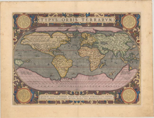
Auction 178, Lot 1
Subject: World
Ortelius, Abraham
Typus Orbis Terrarum, 1587
Size: 19.1 x 13.9 inches (48.5 x 35.3 cm)
Estimate: $6,000 - $7,500
Ortelius' Third World Map in an Oval Projection
Sold for: $4,000
Closed on 6/10/2020
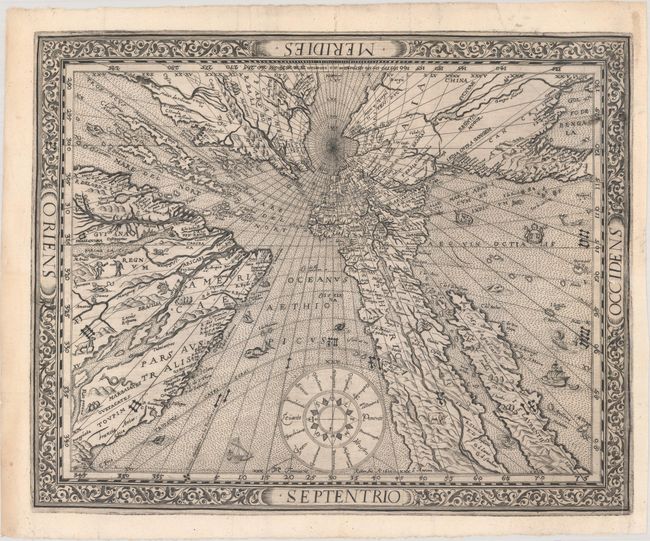
Auction 178, Lot 3
Subject: World
Ritter, Franz
[Untitled - World], 1610
Size: 14.4 x 11.6 inches (36.6 x 29.5 cm)
Estimate: $11,500 - $13,000
Ritter's Fascinating Sundial World Map - First State
Sold for: $8,000
Closed on 6/10/2020
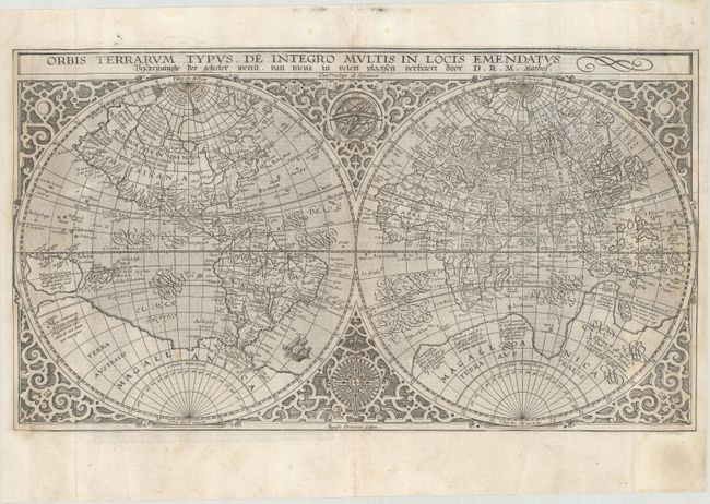
Auction 178, Lot 4
Subject: World
Plancius, Petrus
Orbis Terrarum Typus de Integro Multis in Locis Emendatus, 1647
Size: 20.1 x 11.3 inches (51.1 x 28.7 cm)
Estimate: $1,900 - $2,200
Plancius' World Map Surrounded by Elegant Strapwork
Unsold
Closed on 6/10/2020
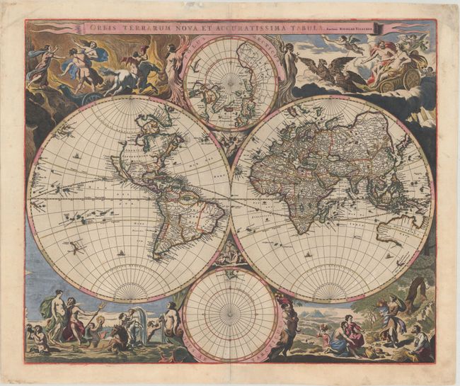
Auction 178, Lot 5
Subject: World
Visscher, Nicolas
Orbis Terrarum Nova et Accuratissima Tabula, 1658
Size: 22.1 x 18.5 inches (56.1 x 47 cm)
Estimate: $5,500 - $6,500
Visscher's Superb Double-Hemisphere World Map in Full Contemporary Color with Gold Highlights
Unsold
Closed on 6/10/2020
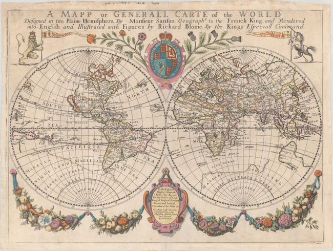
Auction 178, Lot 6
Subject: World
Blome, Richard
A Mapp or Generall Carte of the World Designed in Two Plaine Hemisphers, by Monsieur Sanson..., 1670
Size: 20.9 x 15.5 inches (53.1 x 39.4 cm)
Estimate: $1,500 - $1,800
Scarce English Double-Hemisphere World Map Based on Sanson
Sold for: $1,200
Closed on 6/10/2020
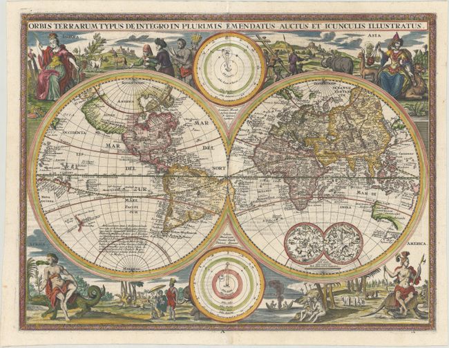
Auction 178, Lot 9
Subject: World
Orbis Terrarum Typus de Integro in Plurimis Emendatus Auctus et Incunculis Illustratus, 1716
Size: 18.8 x 14.3 inches (47.8 x 36.3 cm)
Estimate: $2,000 - $2,400
Rare Variant of Nicolas Visscher's Dutch Bible Map
Sold for: $1,400
Closed on 6/10/2020
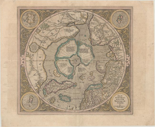
Auction 178, Lot 23
Subject: North Pole
Mercator/Hondius
Septentrionalium Terrarum Descriptio, 1634
Size: 15.5 x 14.5 inches (39.4 x 36.8 cm)
Estimate: $1,600 - $1,900
The First Printed Map Devoted to the Arctic in Full Contemporary Color
Sold for: $2,300
Closed on 6/10/2020
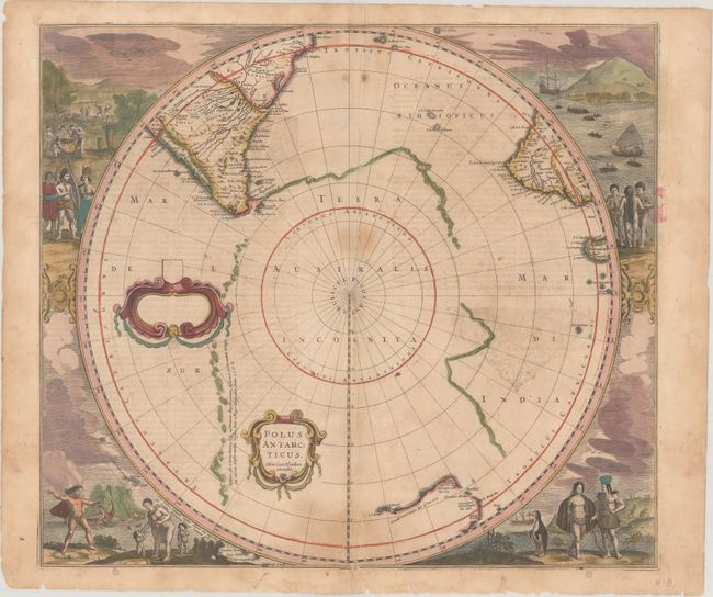
Auction 178, Lot 27
Subject: South Pole
Hondius, Henricus
Polus Antarcticus, 1639
Size: 19.5 x 17.2 inches (49.5 x 43.7 cm)
Estimate: $1,400 - $1,700
Magnificent Early Map of the South Pole in Full Contemporary Color
Unsold
Closed on 6/10/2020
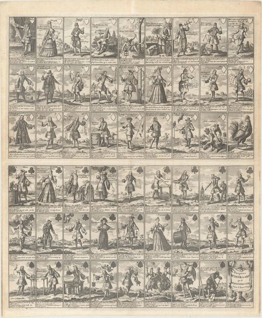
Auction 178, Lot 41
Subject: Cartographic Miscellany, Playing Cards
Anon.
Pasquins Windkaart. Op de Windnegotie van 't Iaar 1720, 1720
Size: 17.3 x 20.4 inches (43.9 x 51.8 cm)
Estimate: $1,500 - $1,800
Sheet of Playing Cards Satirizing the Mississippi Bubble
Unsold
Closed on 6/10/2020
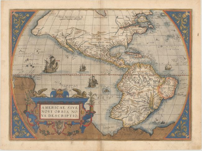
Auction 178, Lot 43
Subject: Western Hemisphere - America
Ortelius, Abraham
Americae sive Novi Orbis, Nova Descriptio, 1579
Size: 19.6 x 14.1 inches (49.8 x 35.8 cm)
Estimate: $5,000 - $6,000
Ortelius' Influential Map of the New World - Second Plate in Contemporary Color
Sold for: $3,750
Closed on 6/10/2020
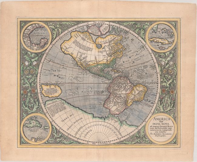
Auction 178, Lot 44
Subject: Western Hemisphere - America
Mercator, Michael
America sive India Nova, ad Magnae Gerardi Mercatoris aui Universalis Imitationem, in Compendium Redacta, 1628
Size: 18.1 x 14.4 inches (46 x 36.6 cm)
Estimate: $3,500 - $4,250
Mercator's Foundation Map for the Americas
Sold for: $2,500
Closed on 6/10/2020
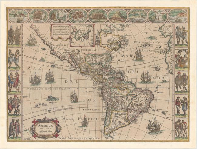
Auction 178, Lot 45
Subject: Western Hemisphere - America
Blaeu, Willem
Americae Nova Tabula, 1630
Size: 21.8 x 16.3 inches (55.4 x 41.4 cm)
Estimate: $5,000 - $6,000
Blaeu's Stunning Carte-a-Figures Map of the Americas
Unsold
Closed on 6/10/2020
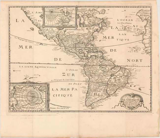
Auction 178, Lot 47
Subject: Western Hemisphere - America
Bertius/Tavernier
Carte de l'Amerique Corrigee et Augmentee; Dessus Toutes les Aultres cy Devant Faictes, 1661
Size: 14.3 x 10.8 inches (36.3 x 27.4 cm)
Estimate: $1,400 - $1,700
Rare Derivative of Hondius' Influential Map
Sold for: $1,000
Closed on 6/10/2020
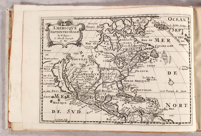
Auction 178, Lot 48
Subject: Western Hemisphere - America
Sanson, Nicolas
L'Amerique en Plusieurs Cartes Nouvelles et Exactes; et en Divers Traittez de Geographie & d'Histoire..., 1699
Size: 13.7 x 9.1 inches (34.8 x 23.1 cm)
Estimate: $5,500 - $6,500
Sanson's Highly Desirable Atlas of the Americas with 15 Maps
Sold for: $4,250
Closed on 6/10/2020
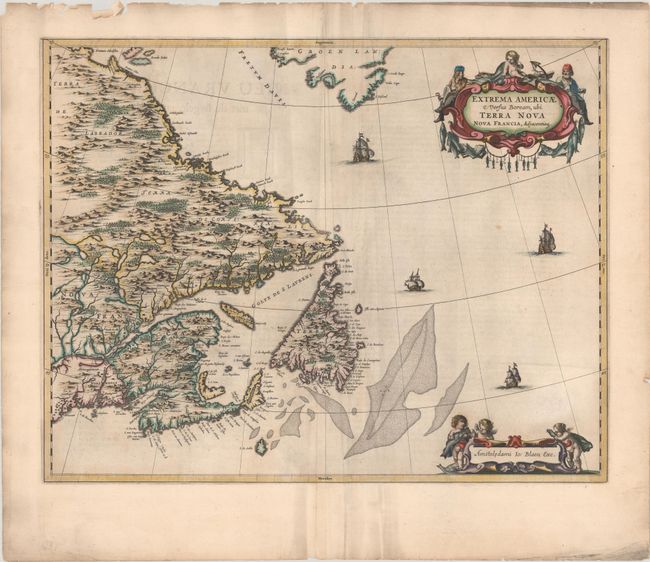
Auction 178, Lot 72
Subject: Eastern Canada
Blaeu, Johannes
Extrema Americae Versus Boream, ubi Terra Nova Nova Francia, Adjacentiaqs, 1664
Size: 22.3 x 17.5 inches (56.6 x 44.5 cm)
Estimate: $1,900 - $2,200
Blaeu's Only Map of Canada, Showing the Canadian Maritimes
Sold for: $1,400
Closed on 6/10/2020
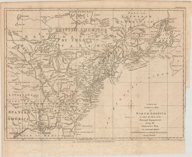
Auction 178, Lot 89
Subject: Eastern United States & Canada
Lodge, John
A New and Correct Map of North America in Which the Places of the Principal Engagements During the Present War, Are Accurately Inserted..., 1783
Size: 14.8 x 10.9 inches (37.6 x 27.7 cm)
Estimate: $3,000 - $4,000
Rare Map Presenting the "Rebel Colonies now the United States of America"
Sold for: $3,750
Closed on 6/10/2020
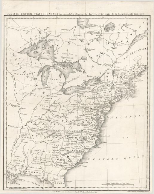
Auction 178, Lot 91
Subject: Eastern United States & Canada, Franklin
Rochefoucald Liancourt, Francois Alexander
Map of the United States, Canada &c. Intended to Illustrate the Travels of the Duke de la Rochefoucault Liancourt, 1799
Size: 13.3 x 15.9 inches (33.8 x 40.4 cm)
Estimate: $1,400 - $1,700
Features the Short-Lived Franklinia and Morgania
Sold for: $1,200
Closed on 6/10/2020
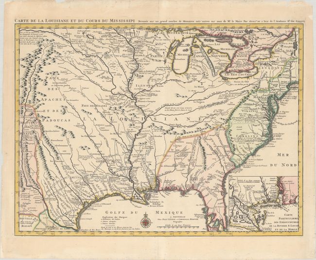
Auction 178, Lot 105
Subject: Colonial Eastern United States, Louisiana Territory
Delisle/Covens & Mortier
Carte de la Louisiane et du Cours du Mississipi Dressee sur un Grand Nombre de Memoires Entr'autres sur ceux de Mr. le Maire, 1730
Size: 23.4 x 17.3 inches (59.4 x 43.9 cm)
Estimate: $1,600 - $1,900
Delisle's Influential Map of the Louisiana Territory
Sold for: $1,400
Closed on 6/10/2020
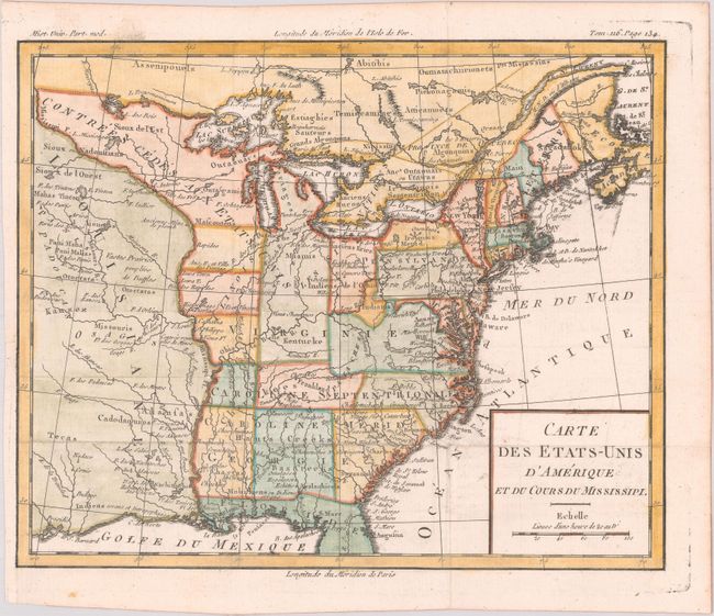
Auction 178, Lot 107
Subject: Eastern United States, Franklin
Brion de la Tour, Louis
Carte des Etats-Unis d'Amerique et du Cours du Mississipi, 1783
Size: 10.6 x 8.7 inches (26.9 x 22.1 cm)
Estimate: $900 - $1,100
One of the Earliest Maps to Feature the State of Franklin
Sold for: $1,100
Closed on 6/10/2020
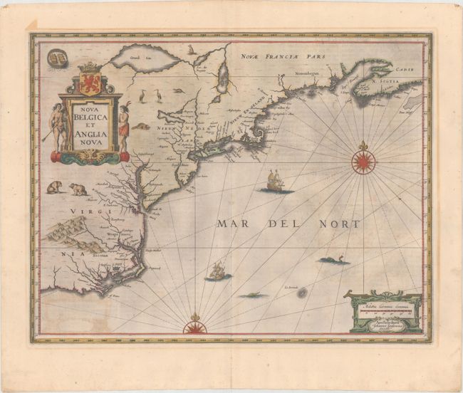
Auction 178, Lot 113
Subject: Colonial New England & Mid-Atlantic United States
Jansson, Jan
Nova Belgica et Anglia Nova, 1644
Size: 19.7 x 15.2 inches (50 x 38.6 cm)
Estimate: $1,600 - $1,900
Jansson's Influential Map of the East Coast - in Contemporary Color
Sold for: $800
Closed on 6/10/2020
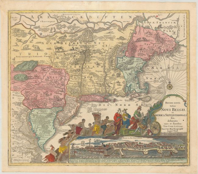
Auction 178, Lot 114
Subject: Colonial New England & Mid-Atlantic United States
Seutter/Lotter
Recens Edita Totius Novi Belgii, in America Septentrionali Siti, Delineatio Cura et Sumtibus, 1760
Size: 22.9 x 19.6 inches (58.2 x 49.8 cm)
Estimate: $2,750 - $3,500
Decorative Edition from Jansson-Visscher Series with View of Manhattan
Sold for: $2,000
Closed on 6/10/2020
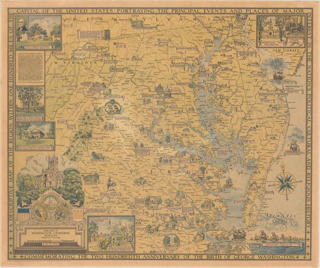
Auction 178, Lot 122
Subject: Mid-Atlantic United States
A Descriptive Map of the Region Within One Hundred Miles of the Capital of the United States..., 1932
Size: 33.3 x 27.6 inches (84.6 x 70.1 cm)
Estimate: $800 - $1,000
Ernest Clegg's Map Commemorating George Washington
Sold for: $500
Closed on 6/10/2020
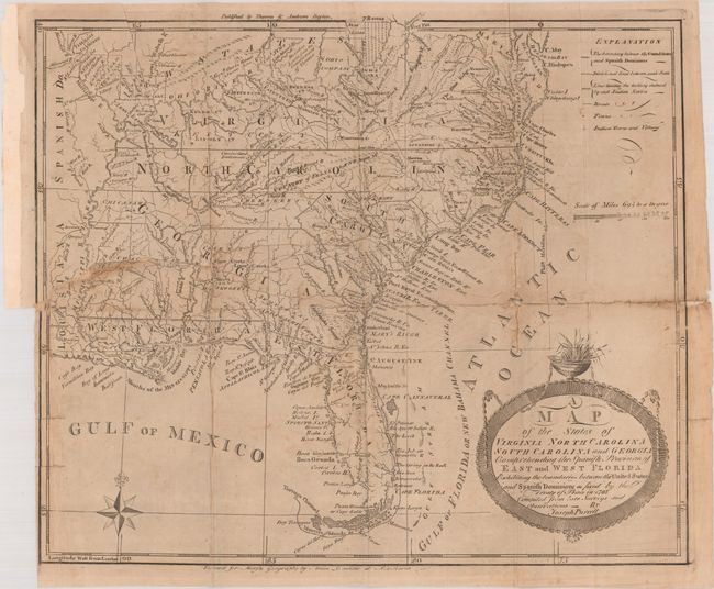
Auction 178, Lot 125
Subject: Southern United States, Franklin
Purcell, Joseph
A Map of the States of Virginia North Carolina South Carolina and Georgia Comprehending the Spanish Provinces of East and West Florida..., 1793
Size: 14.8 x 12.6 inches (37.6 x 32 cm)
Estimate: $700 - $900
Second State of Purcell's Map Locating the Proposed State of Frankland
Sold for: $550
Closed on 6/10/2020
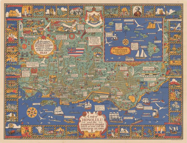
Auction 178, Lot 163
Subject: Honolulu, Hawaii
A Map of Honolulu and the Sandwich Islands Which We Now Call the Hawaiian Islands, 1927
Size: 35.5 x 27.1 inches (90.2 x 68.8 cm)
Estimate: $1,200 - $1,600
Uncommon Pictorial Map of Honolulu Celebrating the Culture and History of the Hawaiian Isles
Sold for: $1,000
Closed on 6/10/2020
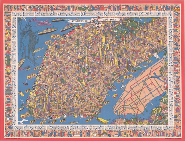
Auction 178, Lot 184
Subject: New York City, New York
Wonders of New York, 1953
Size: 31.8 x 24 inches (80.8 x 61 cm)
Estimate: $700 - $850
Superb Pictorial Map of Manhattan
Sold for: $650
Closed on 6/10/2020
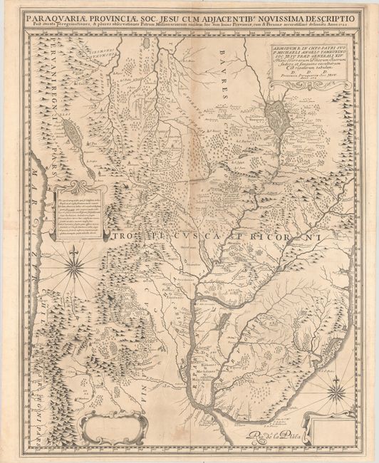
Auction 178, Lot 258
Subject: Central South America, Paraguay
Paraquariae Provinciae Soc. Jesu cum Adjacentib. Novissima Descriptio..., 1722
Size: 21.9 x 28.4 inches (55.6 x 72.1 cm)
Estimate: $4,000 - $4,750
Pre-Publication Proof of Extremely Rare Jesuit Map of Paraguay
Unsold
Closed on 6/10/2020
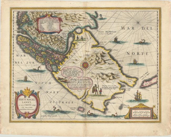
Auction 178, Lot 278
Subject: Tierra del Fuego
Blaeu, Willem
Freti Magellanici ac Novi Freti Vulgo Le Maire Exactissima Delineatio, 1631
Size: 19.4 x 14.8 inches (49.3 x 37.6 cm)
Estimate: $600 - $800
Blaeu's Scarce First Map of the Strait of Magellan
Sold for: $450
Closed on 6/10/2020
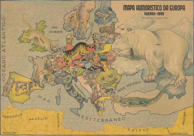
Auction 178, Lot 292
Subject: Europe, World War II
Mapa Humoristico da Europa Guerra - 1939, 1939
Size: 25.4 x 17.9 inches (64.5 x 45.5 cm)
Estimate: $1,800 - $2,100
Very Rare Zoomorphic Map of Europe During WWII
Sold for: $1,200
Closed on 6/10/2020
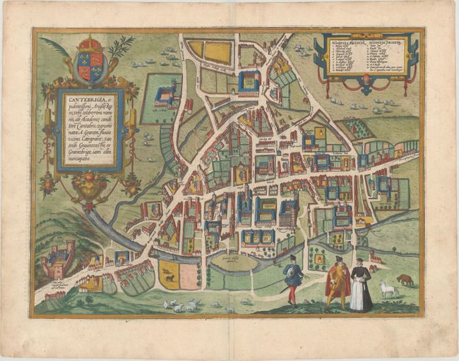
Auction 178, Lot 295
Subject: Cambridge, England
Braun & Hogenberg
Cantebrigia, Opulentissimi Anglie Regni, Urbs Celeberrimi Nominis, ab Academie Conditore Cantabro..., 1590
Size: 17.5 x 12.9 inches (44.5 x 32.8 cm)
Estimate: $950 - $1,200
Earliest Printed Map of Cambridge
Sold for: $900
Closed on 6/10/2020
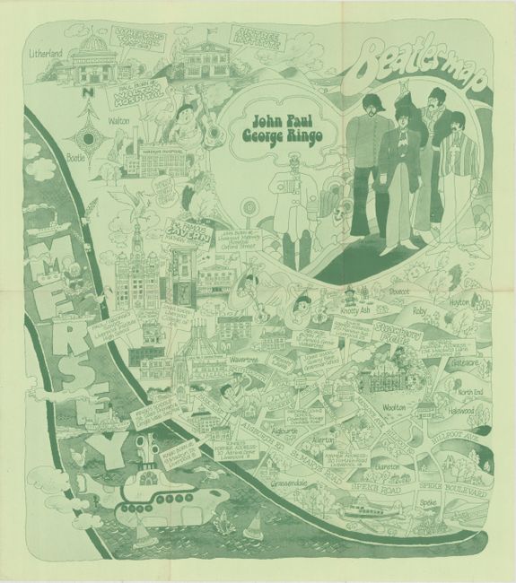
Auction 178, Lot 297
Subject: Liverpool, England
Beatles Map, 1974
Size: 14.5 x 16.8 inches (36.8 x 42.7 cm)
Estimate: $475 - $600
Charming Beatles Map of Liverpool
Sold for: $350
Closed on 6/10/2020
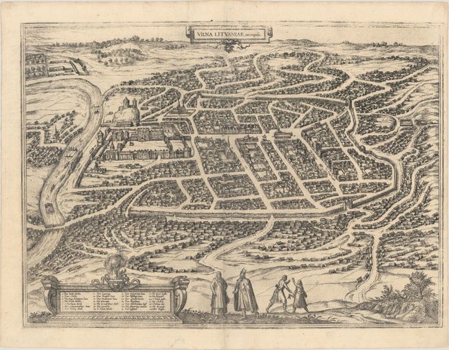
Auction 178, Lot 314
Subject: Vilnius, Lithuania
Braun & Hogenberg
Vilna Lituaniae Metropolis, 1606
Size: 19.6 x 14.4 inches (49.8 x 36.6 cm)
Estimate: $1,600 - $2,000
Superb Bird's-Eye Plan of Vilnius
Sold for: $1,600
Closed on 6/10/2020
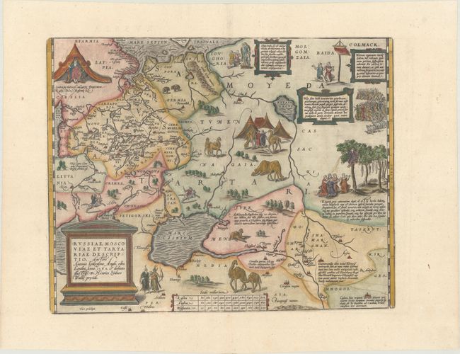
Auction 178, Lot 377
Subject: Russia, Eastern Europe & Central Asia
Ortelius, Abraham
Russiae, Moscoviae et Tartariae Descriptio. Auctore Antonio Ienkensono Anglo..., 1587
Size: 17.6 x 13.9 inches (44.7 x 35.3 cm)
Estimate: $2,000 - $2,300
Ortelius' Map of Russia with a Vignette of Ivan the Terrible
Sold for: $2,000
Closed on 6/10/2020
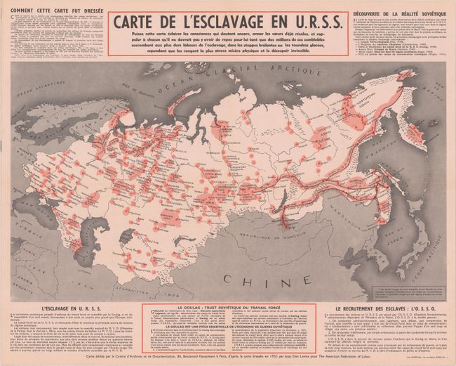
Auction 178, Lot 382
Subject: Russia in Europe, Cold War
Carte de l'Esclavage en U.R.S.S., 1951
Size: 20.9 x 16.6 inches (53.1 x 42.2 cm)
Estimate: $600 - $800
Map Documenting Soviet Gulag System
Sold for: $250
Closed on 6/10/2020
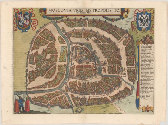
Auction 178, Lot 383
Subject: Moscow, Russia
Braun & Hogenberg
Moscovia Urbs Metropolis Totius Russiae Albae, 1617
Size: 18.1 x 13.7 inches (46 x 34.8 cm)
Estimate: $1,600 - $1,900
Splendid Bird's-Eye View of Moscow
Sold for: $1,300
Closed on 6/10/2020
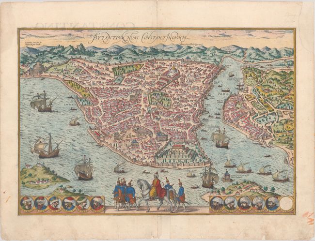
Auction 178, Lot 433
Subject: Istanbul, Turkey
Braun & Hogenberg
Byzantium, nunc Constantinopolis, 1572
Size: 19 x 12.9 inches (48.3 x 32.8 cm)
Estimate: $1,600 - $1,900
Superb Bird's-Eye View During the Golden Age of the Ottoman Empire
Sold for: $1,400
Closed on 6/10/2020
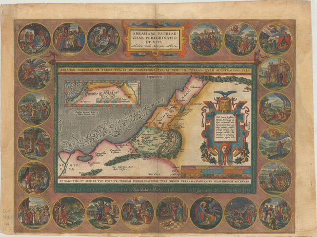
Auction 178, Lot 436
Subject: Holy Land
Ortelius, Abraham
Abrahami Patriarchae Peregrinatio, et Vita, 1586
Size: 18.3 x 14 inches (46.5 x 35.6 cm)
Estimate: $1,400 - $1,700
Elaborate Map of the Holy Land, Illustrating the Life of Abraham
Sold for: $800
Closed on 6/10/2020
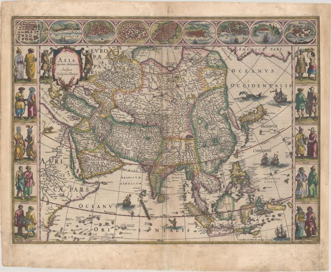
Auction 178, Lot 465
Subject: Asia
Blaeu, Willem
Asia Noviter Delineata, 1635
Size: 21.9 x 16.3 inches (55.6 x 41.4 cm)
Estimate: $2,750 - $3,500
Magnificent Carte-a-Figures Map of Asia in Full Contemporary Color
Sold for: $1,900
Closed on 6/10/2020
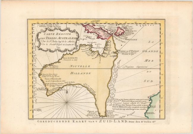
Auction 178, Lot 544
Subject: Australia
Bellin/Van Schley
Carte Reduite des Terres Australes, 1753
Size: 10.8 x 7.9 inches (27.4 x 20.1 cm)
Estimate: $900 - $1,100
A Rare Pre-Cook Map Focusing on Australia
Sold for: $900
Closed on 6/10/2020
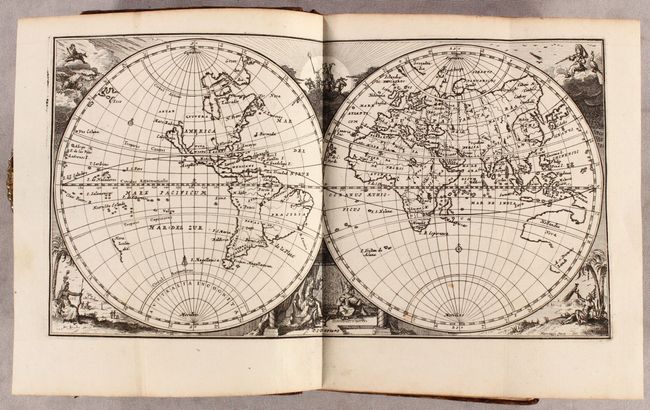
Auction 178, Lot 590
Subject: Atlases
Ptolemy/Ruscelli
La Geografia di Claudio Tolomeo Alessandrino..., 1574
Size: 6.5 x 9.2 inches (16.5 x 23.4 cm)
Estimate: $8,000 - $10,000
Ruscelli's Complete, Third Edition Atlas
Sold for: $6,000
Closed on 6/10/2020
Auction 178, Lot 591
Subject: Atlases
Duval/Beer
[Geographia Universalis...], 1678
Size: 6.1 x 4.9 inches (15.5 x 12.4 cm)
Estimate: $5,500 - $6,500
Miniature Atlas with 82 Maps Based on Duval
Unsold
Closed on 6/10/2020
Auction 178, Lot 592
Subject: Atlases
Peeters, Jacques
L'Atlas en Abrege, ou Nouvelle Description du Monde, 1692
Size: 4.6 x 7.5 inches (11.7 x 19.1 cm)
Estimate: $3,500 - $4,250
Rare, Complete Atlas with 43 Maps
Sold for: $3,250
Closed on 6/10/2020
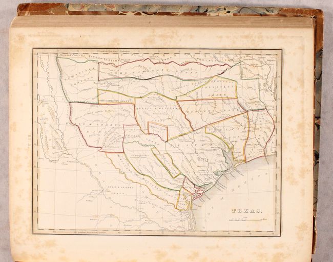
Auction 178, Lot 593
Subject: Atlases, Texas
Bradford, Thomas Gamaliel
A Comprehensive Atlas Geographical, Historical & Commercial, 1835
Size: 10.8 x 13.1 inches (27.4 x 33.3 cm)
Estimate: $2,500 - $3,250
First Printed Atlas to Contain a Separate Map of Texas
Sold for: $2,400
Closed on 6/10/2020
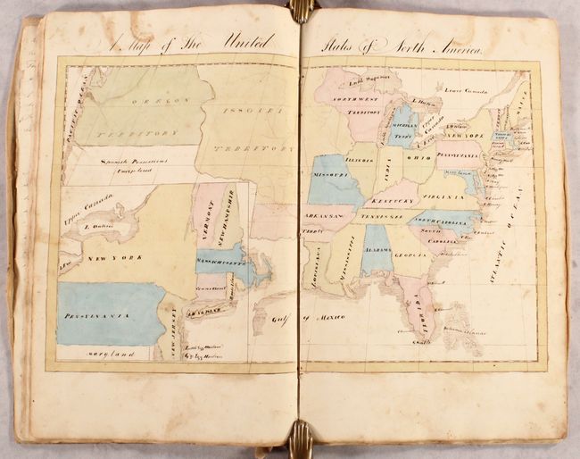
Auction 178, Lot 597
Subject: Geography Books
Geography, 1834
Size: 10.3 x 16 inches (26.2 x 40.6 cm)
Estimate: $1,500 - $2,500
Manuscript Geography Book with 9 Maps and Colorful Commentary
Sold for: $1,000
Closed on 6/10/2020
43 lots