Subject: Asia
Period: 1635 (circa)
Publication: Le Theatre du Monde
Color: Hand Color
Size:
21.9 x 16.3 inches
55.6 x 41.4 cm
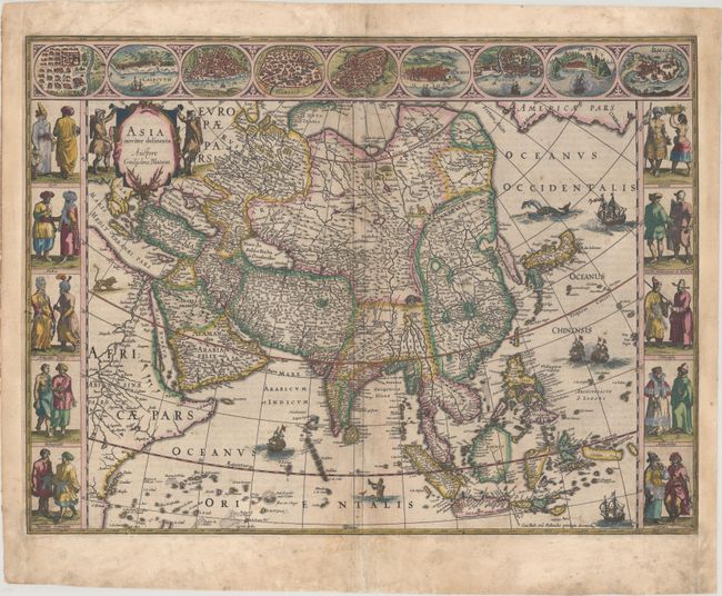
This is one of the most famous 17th century maps of the continent of Asia. It is surrounded by a beautiful carte-a-figures border and is richly ornamented with animals, sea monsters, and sailing ships. The eastern coastline of Asia is severely truncated, Korea is shown as an island, and Japan is depicted on the Ortelius-Teixeira model. The Indian subcontinent is too narrow and the islands of Indonesia are very sketchy. A large island labeled Ceiram probably represents the western part of New Guinea. In the interior, the Caspian Sea is oriented on an east-west axis and there are several large erroneous lakes in China including the mythical Chiamay Lacus. The frieze across the top features vignettes of the cities of Candy, Calecut, Goa, Damascus, Jerusalem, Hormuz, Banten, Aden, and Macao. The inclusion of Banten reflects the emergence of the Dutch as a major commercial power in the East Indies. The side panels flanking the map depict costumed figures of the various Asian peoples. French text on verso, published between 1635-38.
References: Van der Krogt (Vol. II) #8000:2; Walter #25; Yeo #24.
Condition: B+
A sharp impression with full contemporary color, light soiling the is more pronounced in the blank margins, and professional repairs to some separations along the centerfold. Professionally remargined at right and left to accommodate framing.