Subject: Australia
Period: 1753 (dated)
Publication: Historische Beschryving der Reizen... en Land-Togten...
Color: Hand Color
Size:
10.8 x 7.9 inches
27.4 x 20.1 cm
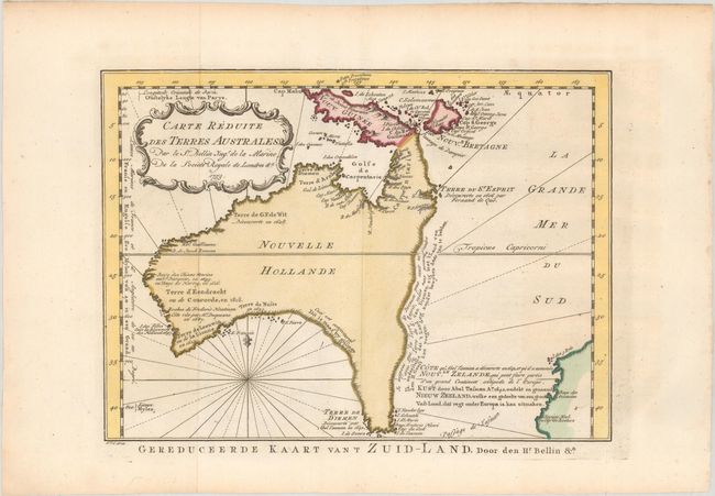
This is the scarcer Dutch version of one of the few 18th century maps to focus on the Australian continent prior to Cook's famous first voyage from 1768-1771. Mainland Australia is connected to both Tasmania (Terre de Van Diemen) and Papua New Guinea (Nouv. Guinee). Along the imaginary eastern coastline is a note that reads: "I suppose that the land of Diemen can join with the land of the Holy Ghost, but this is without proof." A partial coastline of New Zealand is shown peeking out of the corner of the map, with a note that it was discovered by Abel Tasman in 1642 and speculation that it might be part of a great southern continent. This is an important map of Australia depicting the interesting theories made prior to exploration of the region later in the century. Notes are shown in both French and Dutch text, and an alternate Dutch title, Gereduceerde Kaart van 't Zuid-Land, runs below the neatline. Engraved by J. Van Schley.
References: Tooley (Australia) p. 24, #157; Tooley (MCC-23) #80.
Condition: A
A crisp impression issued folding on watermarked paper with minor offsetting.