Subject: World
Period: 1670 (circa)
Publication:
Color: Hand Color
Size:
20.9 x 15.5 inches
53.1 x 39.4 cm
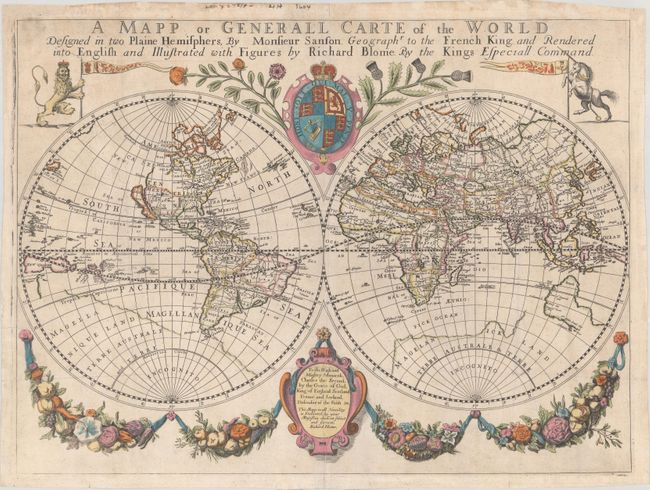
This scarce and ornate double hemisphere world map is derived from Nicolas Sanson. It depicts California as an island, and Acoma, Santa Fe, and N. Mexico are noted in the Southwest. Cibola is named in the Pacific Northwest. The northwestern portion of the continent is left incomplete. New Danemarc and the Christian Sea are located west of the Hudson Bay. The Great Lakes are copied from Sanson's map, which was the first to name Lac Superior and Lake Michigan, here called Lac des puans (Lake of Evil Smells). In South America the mythical Lake Parime is identified. An unusually shaped Australia is also copied from Sanson, with Beach appearing on its northern tip. The map is surrounded by decorative elements, including hanging garlands, the royal arms of Charles II, and a dedicatory cartouche. It was first published in A Geographical Description of the Four Parts of the World... (1670), with subsequent editions found in Bernhard Varenius' Cosmography & Geography (1682-93). According to Shirley, Francis Lamb is likely the engraver.
References: Shirley #455; Wagner (NW) #400b.
Condition: B+
On watermarked paper that has been backed on tissue with some light soiling along the sheet edges. There are a couple of printer's creases, faint offsetting, a few minor abrasions in the decorative elements above the map, and some small chips in the blank margins that have been archivally repaired.