Showing Featured Lots(remove filter)
Showing results for:Auction 176
Catalog Archive
58 lots
Page 1 of 2
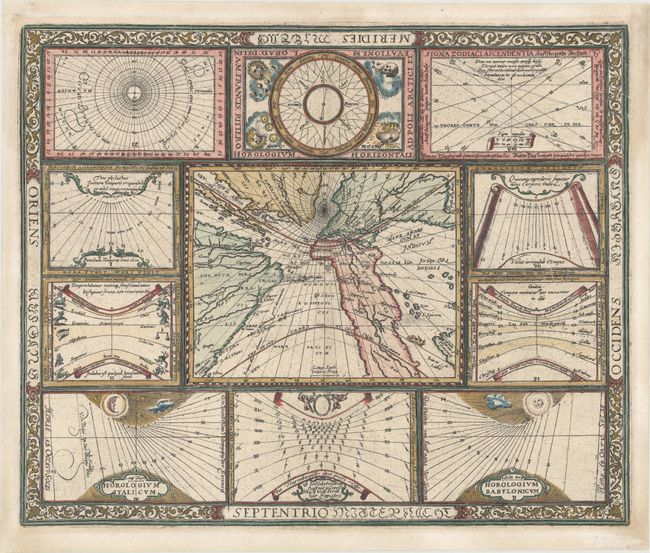
Auction 176, Lot 2
Subject: World
Ritter, Franz
[Untitled - World and Horological Diagrams], 1607
Size: 13.6 x 11.2 inches (34.5 x 28.4 cm)
Estimate: $3,250 - $4,000
Ritter's Unusual Sun-Dial World Map - First State
Unsold
Closed on 2/12/2020
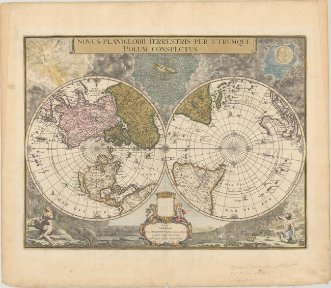
Auction 176, Lot 6
Subject: World
Blaeu/Valck
Novus Planiglobii Terrestris per Utrumque Polum Conspectus, 1695
Size: 21.3 x 16 inches (54.1 x 40.6 cm)
Estimate: $5,000 - $6,500
Superb World Map on a Polar Projection
Sold for: $3,000
Closed on 2/12/2020
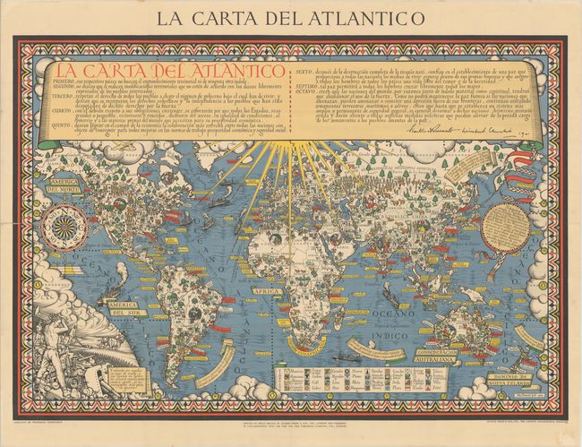
Auction 176, Lot 17
Subject: World, World War II
Gill, MacDonald
La Carta del Atlantico, 1943
Size: 43.1 x 29.8 inches (109.5 x 75.7 cm)
Estimate: $3,250 - $4,000
Rare Spanish Edition of Gill's "Time & Tide" Map of the Atlantic Charter
Sold for: $1,500
Closed on 2/12/2020
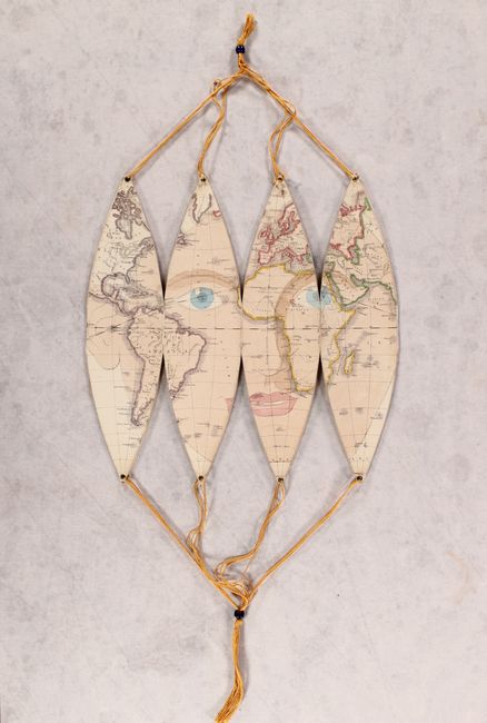
Auction 176, Lot 29
Subject: Globes
[7.6" Folding Globe] Stokes's Capital Mnemonical Globe, 1868
Size: 6 x 11.8 inches (15.2 x 30 cm)
Estimate: $1,900 - $2,300
Rare Mnemonic Teaching Globe with Superimposed Human Face
Sold for: $3,000
Closed on 2/12/2020
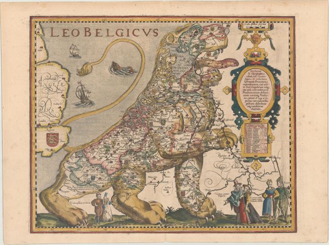
Auction 176, Lot 30
Subject: Cartographic Miscellany, Low Countries
Keere, Pieter Van Den
Leo Belgicus, 1617
Size: 17.9 x 14.6 inches (45.5 x 37.1 cm)
Estimate: $15,000 - $18,000
Most Popular of the "Lions of Belgium"
Unsold
Closed on 2/12/2020
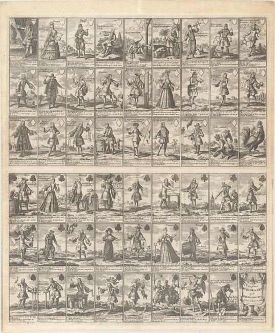
Auction 176, Lot 37
Subject: Cartographic Miscellany, Playing Cards
Anon.
Pasquins Windkaart. Op de Windnegotie van 't Iaar 1720, 1720
Size: 17.3 x 20.4 inches (43.9 x 51.8 cm)
Estimate: $1,600 - $1,900
Sheet of Playing Cards Satirizing the Mississippi Bubble
Unsold
Closed on 2/12/2020
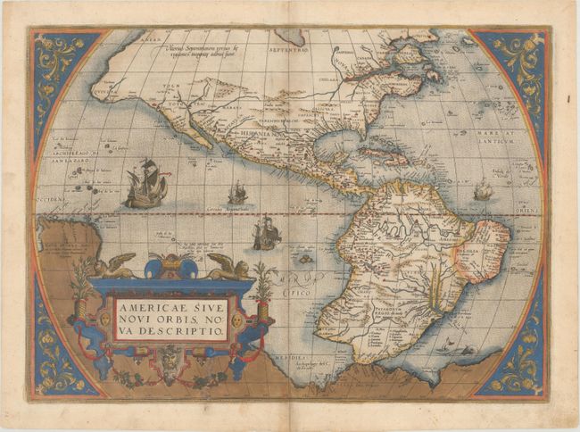
Auction 176, Lot 41
Subject: Western Hemisphere - America
Ortelius, Abraham
Americae sive Novi Orbis, Nova Descriptio, 1579
Size: 19.6 x 14.1 inches (49.8 x 35.8 cm)
Estimate: $5,500 - $6,500
Ortelius' Influential Map of the New World - Second Plate in Contemporary Color
Unsold
Closed on 2/12/2020
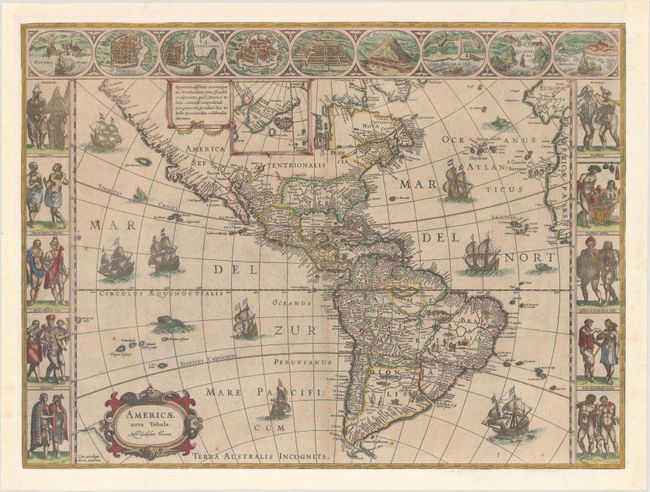
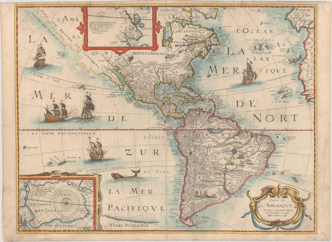
Auction 176, Lot 42
Subject: Western Hemisphere - America
Blaeu, Willem
Americae Nova Tabula, 1630
Size: 21.8 x 16.3 inches (55.4 x 41.4 cm)
Estimate: $5,500 - $6,500
Blaeu's Stunning Carte-a-Figures Map of the Americas
Unsold
Closed on 2/12/2020
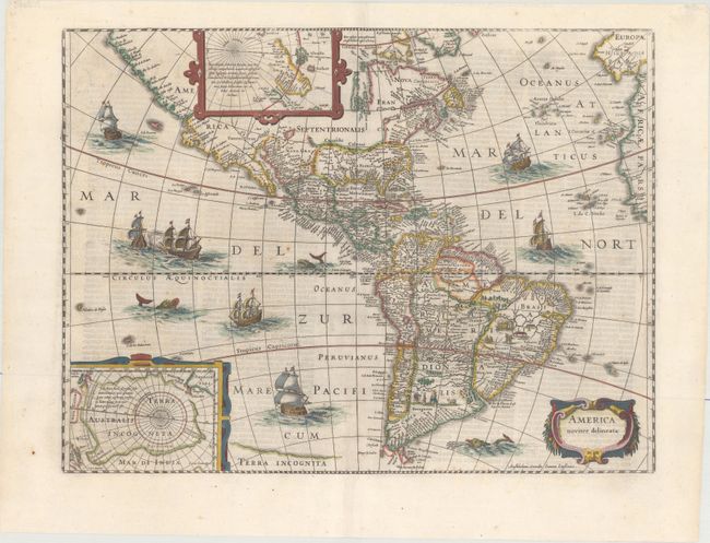
Auction 176, Lot 44
Subject: Western Hemisphere - America
Hondius/Jansson
America Noviter Delineata, 1645
Size: 19.8 x 14.9 inches (50.3 x 37.8 cm)
Estimate: $1,900 - $2,200
Jansson's Decorative Map of the Americas
Sold for: $1,200
Closed on 2/12/2020
Auction 176, Lot 45
Subject: Western Hemisphere - America
Bertius, Petrus
Carte de l'Amerique Corrigee, et Augmentee Dessus Toutes les Aultres cy Devant Faictes, 1646
Size: 19.4 x 14.8 inches (49.3 x 37.6 cm)
Estimate: $1,500 - $1,800
Scarce Derivative of Hondius' Map of 1618
Sold for: $1,000
Closed on 2/12/2020
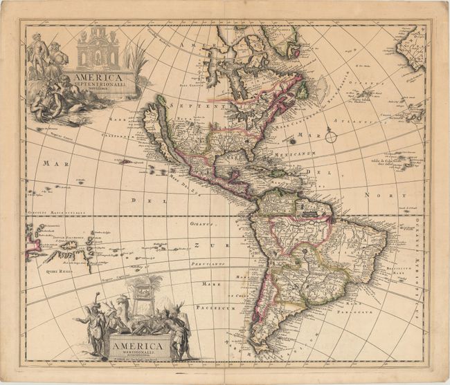
Auction 176, Lot 49
Subject: Western Hemisphere - America
Schenk, Pierre
America Septentrionalis. Novissima / America Meridionalis. Accuratissima, 1695
Size: 22.1 x 18.8 inches (56.1 x 47.8 cm)
Estimate: $1,400 - $1,700
Uncommon Map Featuring Two Figurative Title Cartouches
Sold for: $900
Closed on 2/12/2020
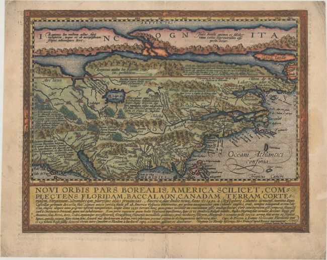
Auction 176, Lot 55
Subject: Colonial North America
Quad, Matthias von Kinckelbach
Novi Orbis Pars Borealis, America Scilicet, Complectens Floridam, Baccalaon, Canadam, Terram Corterialem..., 1600
Size: 11.6 x 8.9 inches (29.5 x 22.6 cm)
Estimate: $2,750 - $3,500
One of the Earliest Maps Devoted to North America
Sold for: $3,250
Closed on 2/12/2020
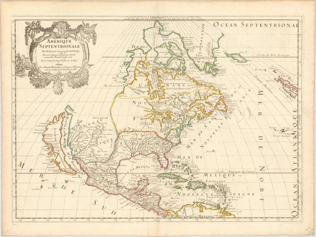
Auction 176, Lot 56
Subject: Colonial North America
Sanson/Mariette
Amerique Septentrionale par N. Sanson..., 1669
Size: 21.9 x 15.6 inches (55.6 x 39.6 cm)
Estimate: $2,200 - $2,500
Important Map for Great Lakes Collectors
Sold for: $1,200
Closed on 2/12/2020
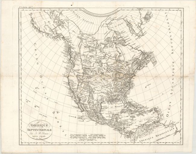
Auction 176, Lot 70
Subject: North America
Poirson, Jean Baptiste
Amerique Septentrionale, 1809
Size: 17.1 x 14.4 inches (43.4 x 36.6 cm)
Estimate: $1,500 - $1,800
One of the Most Advanced, Pre-Lewis & Clark Maps of the Western Interior
Sold for: $1,000
Closed on 2/12/2020
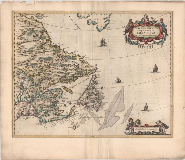
Auction 176, Lot 79
Subject: Eastern Canada
Blaeu, Johannes
Extrema Americae Versus Boream, ubi Terra Nova Nova Francia, Adjacentiaqs, 1664
Size: 22.3 x 17.5 inches (56.6 x 44.5 cm)
Estimate: $1,900 - $2,200
Blaeu's Only Map of Canada, Showing the Canadian Maritimes
Unsold
Closed on 2/12/2020
Auction 176, Lot 86
Subject: Hudson Bay, Canada
Dudley, Robert (Sir)
Carta Particolare dello Istreto e Mare Iscoperto da Heno. Hudson Ingilese nel 1611..., 1661
Size: 18.7 x 27.9 inches (47.5 x 70.9 cm)
Estimate: $4,750 - $5,500
The First Printed Chart of Hudson Bay and Hudson Strait
Sold for: $3,000
Closed on 2/12/2020
Auction 176, Lot 89
Subject: Colonial Eastern United States & Canada
Sanson/Mariette
Le Canada, ou Nouvelle France, &c. ce qui est le Plus Advance vers le Septentrion est Tire de Diverses Relations des Anglois, Danois, &c..., 1656
Size: 21.3 x 15.6 inches (54.1 x 39.6 cm)
Estimate: $4,000 - $5,000
Keystone Map for Great Lakes Collections
Sold for: $2,000
Closed on 2/12/2020
Auction 176, Lot 90
Subject: Colonial Eastern United States & Canada
Moll, Herman
A New and Exact Map of the Dominions of the King of Great Britain on ye Continent of North America..., 1715
Size: 24.1 x 39.9 inches (61.2 x 101.3 cm)
Estimate: $17,000 - $20,000
Moll's Rare and Highly Desirable "Beaver Map" in Contemporary Color
Sold for: $12,000
Closed on 2/12/2020
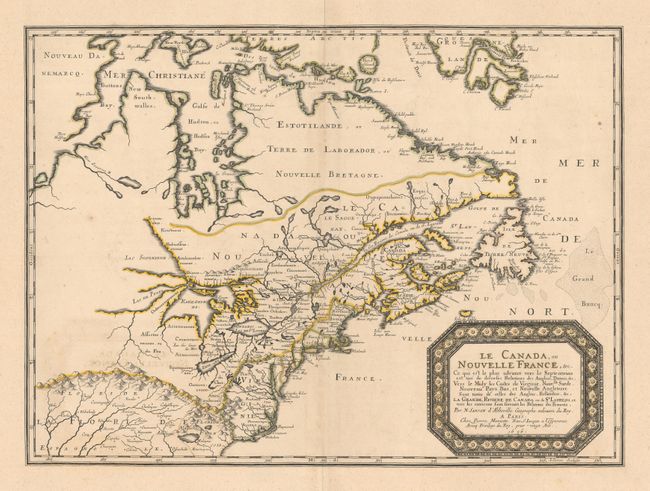
Auction 176, Lot 91
Subject: Colonial Eastern United States & Canada
Chatelain, Henry Abraham
Carte de la Nouvelle France, ou se voit le Cours des Grandes Rivieres de S. Laurens & de Mississipi Aujour d'hui S. Louis, aux Environs des-quelles se Trouvent les Etats, Pais, Nations, Peuples &c..., 1719
Size: 19.3 x 16.6 inches (49 x 42.2 cm)
Estimate: $3,000 - $3,750
One of the Most Informative 18th Century Maps of the French Possessions in North America
Sold for: $2,750
Closed on 2/12/2020
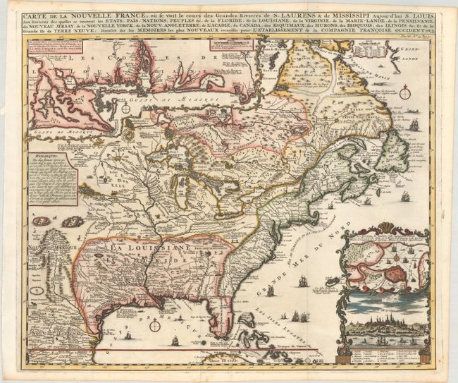
Auction 176, Lot 92
Subject: Colonial Eastern United States & Canada
Delisle/Covens & Mortier
Carte du Canada ou de la Nouvelle France et des Decouvertes qui y ont ete Faites..., 1730
Size: 22.6 x 19.3 inches (57.4 x 49 cm)
Estimate: $1,200 - $1,500
One of the Most Influential Maps of Canada, Great Lakes & Upper Midwest
Sold for: $900
Closed on 2/12/2020
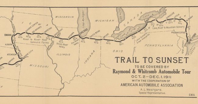
Auction 176, Lot 106
Subject: United States, Auto Trails
American Automobile Assoc.
[Brochure with Map] The Trail to the Sunset Coast to Coast by Automobile, 1911
Size: 29.9 x 6.5 inches (75.9 x 16.5 cm)
Estimate: $200 - $250
The First Commercial Transcontinental Auto Tour
Sold for: $210
Closed on 2/12/2020
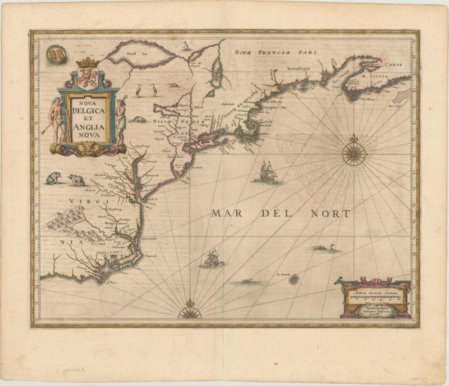
Auction 176, Lot 122
Subject: Colonial New England & Mid-Atlantic United States
Jansson, Jan
Nova Belgica et Anglia Nova, 1646
Size: 19.9 x 15.3 inches (50.5 x 38.9 cm)
Estimate: $1,600 - $1,900
Jansson's Influential Map of the East Coast - in Contemporary Color
Unsold
Closed on 2/12/2020
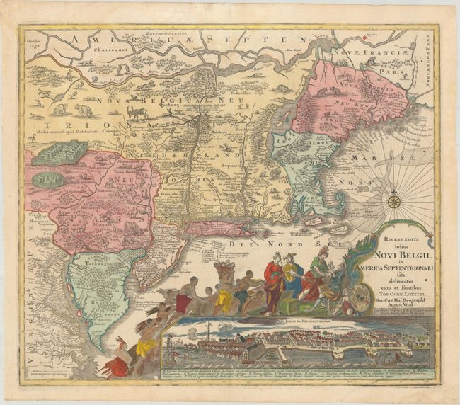
Auction 176, Lot 126
Subject: Colonial New England & Mid-Atlantic United States
Seutter/Lotter
Recens Edita Totius Novi Belgii, in America Septentrionali Siti, Delineatio Cura et Sumtibus, 1760
Size: 22.9 x 19.6 inches (58.2 x 49.8 cm)
Estimate: $2,750 - $3,500
Decorative Edition from Jansson-Visscher Series with View of Manhattan
Unsold
Closed on 2/12/2020
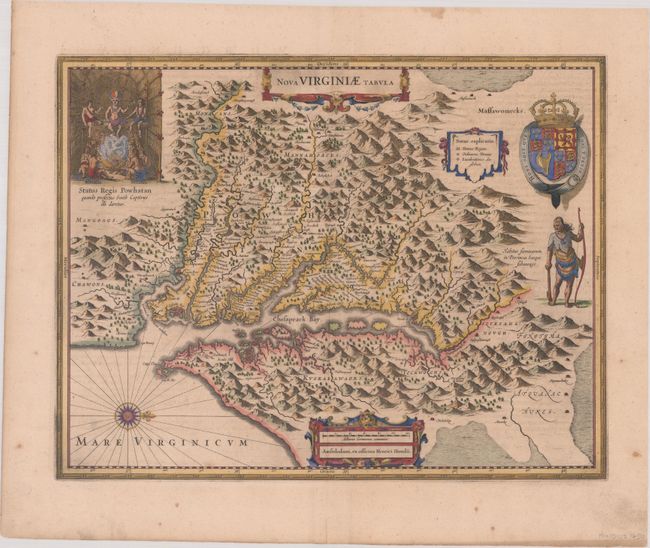
Auction 176, Lot 135
Subject: Colonial Mid-Atlantic United States
Hondius, Henricus
Nova Virginiae Tabula, 1646
Size: 19.4 x 15 inches (49.3 x 38.1 cm)
Estimate: $1,800 - $2,100
One of the Most Important 17th Century Maps of the Chesapeake Bay
Sold for: $1,100
Closed on 2/12/2020
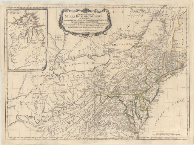
Auction 176, Lot 138
Subject: Colonial Mid-Atlantic United States
Sayer & Bennett
A General Map of the Middle British Colonies, in America. Containing Virginia, Maryland, the Delaware Counties, Pennsylvania and New Jersey..., 1776
Size: 25.9 x 19.1 inches (65.8 x 48.5 cm)
Estimate: $2,750 - $3,500
Derivative of Lewis Evans' map of the Middle British Colonies
Sold for: $2,000
Closed on 2/12/2020
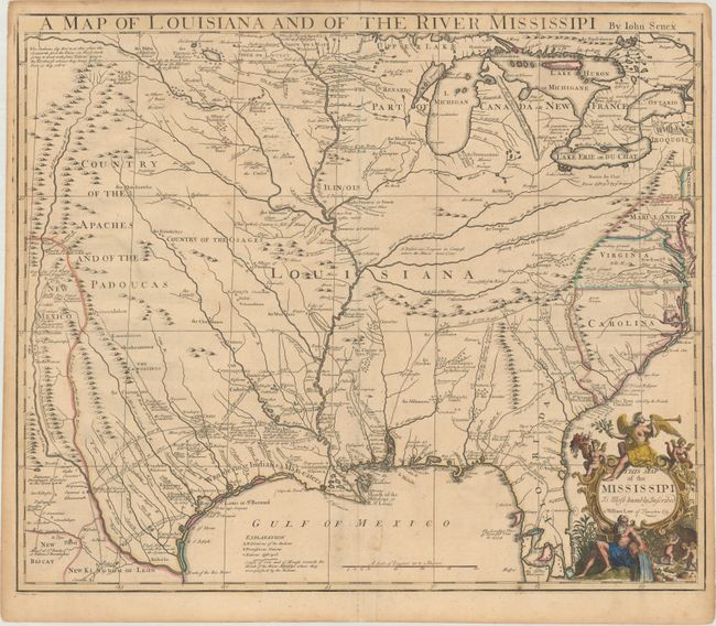
Auction 176, Lot 152
Subject: Colonial South Central United States, Louisiana
Senex, John
A Map of Louisiana and of the River Mississipi, 1721
Size: 22.6 x 19 inches (57.4 x 48.3 cm)
Estimate: $2,500 - $3,250
Important Map of Colonial Louisiana and the Mississippi River
Sold for: $1,600
Closed on 2/12/2020
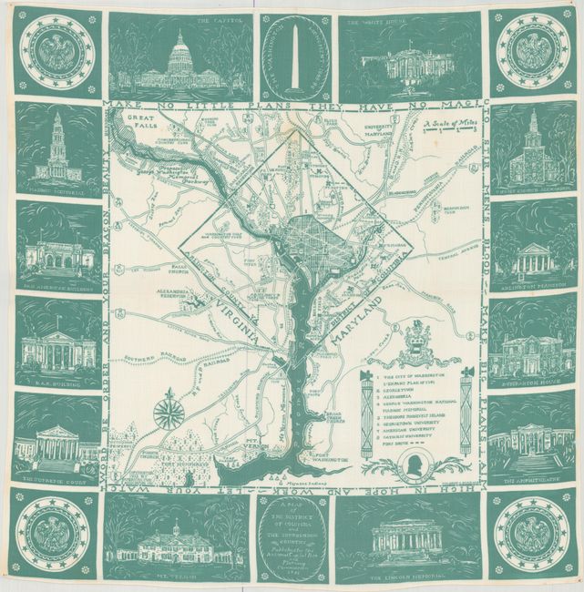
Auction 176, Lot 201
Subject: Washington, D.C.
A Map of the District of Columbia and the Surrounding Country, 1933
Size: 25.9 x 25.9 inches (65.8 x 65.8 cm)
Estimate: $550 - $750
Uncommon Handkerchief Map of DC Based on Original L'Enfant Plan
Sold for: $350
Closed on 2/12/2020
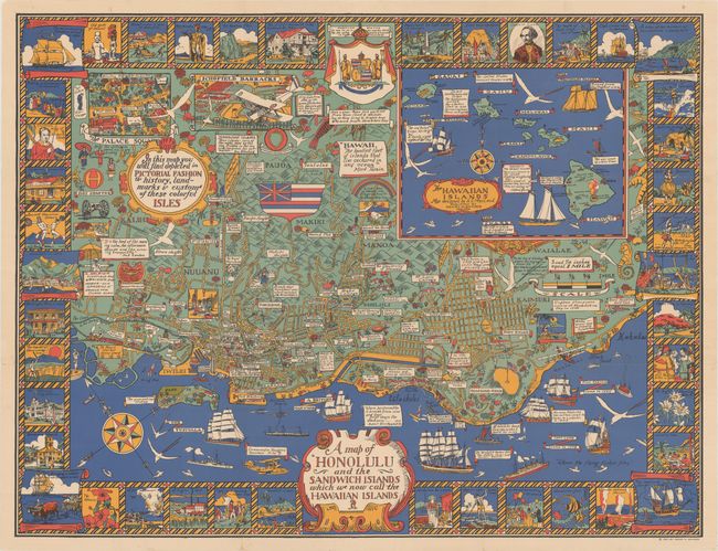
Auction 176, Lot 209
Subject: Honolulu, Hawaii
A Map of Honolulu and the Sandwich Islands Which We Now Call the Hawaiian Islands, 1927
Size: 35.5 x 27.1 inches (90.2 x 68.8 cm)
Estimate: $1,800 - $2,200
Uncommon Pictorial Map of Honolulu Celebrating the Culture and History of the Hawaiian Isles
Unsold
Closed on 2/12/2020
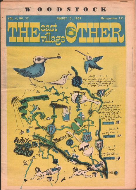
Auction 176, Lot 236
Subject: Woodstock, New York
Woodstock - The East Village Other, 1969
Size: 10 x 14.6 inches (25.4 x 37.1 cm)
Estimate: $350 - $425
Counterculture Newspaper Promoting 1969 Woodstock Festival
Sold for: $300
Closed on 2/12/2020
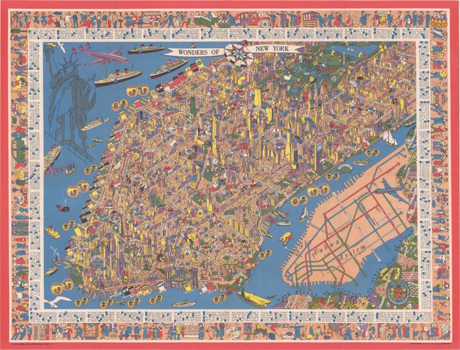
Auction 176, Lot 239
Subject: New York City, New York
Wonders of New York, 1953
Size: 31.5 x 23.6 inches (80 x 59.9 cm)
Estimate: $700 - $850
Superb Pictorial Map of Manhattan
Sold for: $650
Closed on 2/12/2020
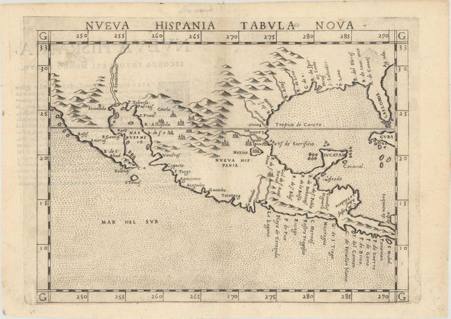
Auction 176, Lot 267
Subject: Southern United States & Mexico
Ruscelli, Girolamo
Nueva Hispania Tabula Nova, 1574
Size: 9.6 x 7.1 inches (24.4 x 18 cm)
Estimate: $1,100 - $1,400
A Foundation Map for the American Southwest
Sold for: $950
Closed on 2/12/2020
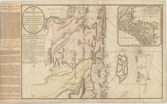
Auction 176, Lot 289
Subject: Belize
Faden, William
A Map of a Part of Yucatan, or of That Part of the Eastern Shore Within the Bay of Honduras Alloted to Great Britain for the Cutting of Logwood..., 1787
Size: 30.8 x 20.7 inches (78.2 x 52.6 cm)
Estimate: $1,600 - $2,000
Rare Foundation Map for Belize Outlining the British Logging Industry
Sold for: $2,200
Closed on 2/12/2020
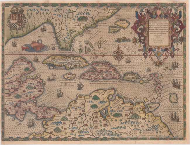
Auction 176, Lot 294
Subject: Gulf of Mexico & Caribbean
Bry, Theodore de
Occidentalis Americae Partis, vel, Earum Regionum quas Christophorus Columbus Primu Detexit Tabula Chorographicae Multorum Auctorum Scriptis..., 1594
Size: 17.3 x 13 inches (43.9 x 33 cm)
Estimate: $7,000 - $8,500
De Bry's Superb Map of the Southeastern US, Caribbean & Northern South America
Sold for: $5,000
Closed on 2/12/2020
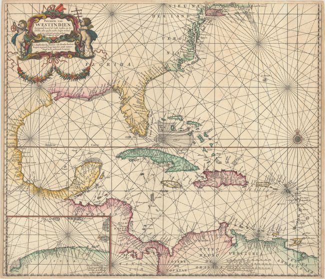
Auction 176, Lot 295
Subject: Gulf of Mexico & Caribbean
Keulen, Johannes van
Pascaerte van Westindien Begrypende in zich de Vaste Kusten en Eylanden, Alles op syn Waere Lengte en Breete op Wassende Graden Gelegt, 1681
Size: 23.6 x 20.4 inches (59.9 x 51.8 cm)
Estimate: $2,000 - $2,400
Rare Dutch Sea Chart of the Gulf of Mexico and Caribbean
Sold for: $2,500
Closed on 2/12/2020
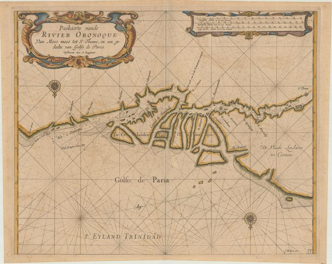
Auction 176, Lot 336
Subject: Venezuela
Roggeveen, Arent
Paskaerte vande Rivier Oronoque van Moco Moco tot St. Thome, en een Gedeelte van Golfo de Paria, 1690
Size: 19.8 x 16 inches (50.3 x 40.6 cm)
Estimate: $1,600 - $1,900
Rare Dutch Sea Chart of Entrance to Orinoco River
Sold for: $1,000
Closed on 2/12/2020
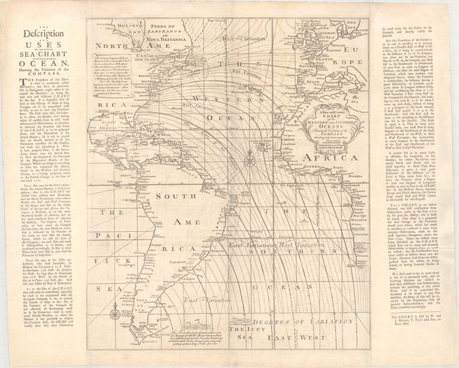
Auction 176, Lot 362
Subject: Atlantic Ocean
Mount & Page
A New and Correct Chart of the Western and Southern Oceans Shewing the Variations of the Compass According to the Latest and Best Observations, 1749
Size: 19.6 x 23 inches (49.8 x 58.4 cm)
Estimate: $1,400 - $1,700
Rare Halley Chart Showing Magnetic Variation
Sold for: $700
Closed on 2/12/2020
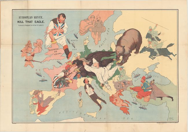
Auction 176, Lot 370
Subject: Europe, World War I
Geographia Map Co
European Revue. Kill That Eagle, 1914
Size: 28.3 x 19.3 inches (71.9 x 49 cm)
Estimate: $2,000 - $2,300
Rare Satirical Map of Europe at Start of World War I
Sold for: $2,000
Closed on 2/12/2020
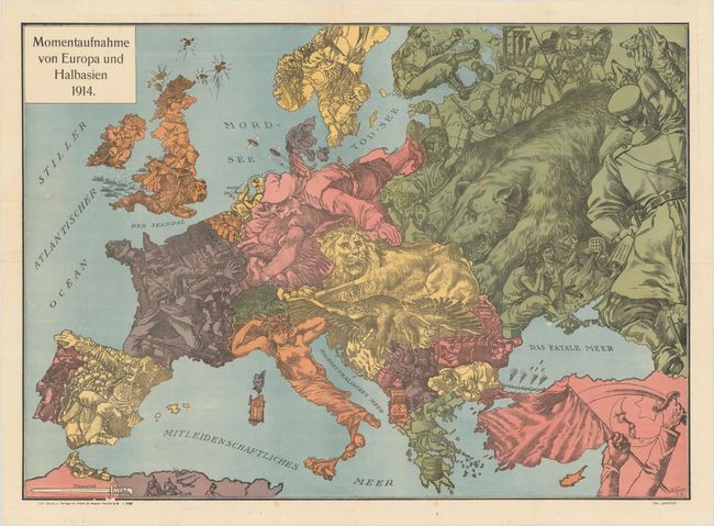
Auction 176, Lot 371
Subject: Europe, World War I
Momentaufnahme von Europa und Halbasien 1914, 1914
Size: 26.6 x 19 inches (67.6 x 48.3 cm)
Estimate: $1,200 - $1,500
Rare Propaganda Map from WWI in Support of Central Powers
Sold for: $900
Closed on 2/12/2020
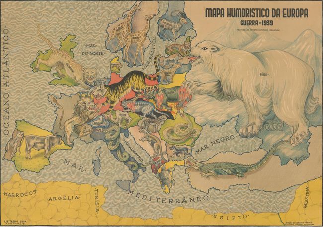
Auction 176, Lot 372
Subject: Europe, World War II
Mapa Humoristico da Europa Guerra - 1939, 1939
Size: 25.4 x 17.9 inches (64.5 x 45.5 cm)
Estimate: $2,300 - $2,750
Very Rare Zoomorphic Map of Europe During WWII
Unsold
Closed on 2/12/2020
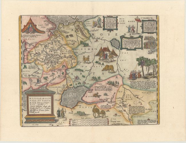
Auction 176, Lot 498
Subject: Russia, Eastern Europe & Central Asia
Ortelius, Abraham
Russiae, Moscoviae et Tartariae Descriptio. Auctore Antonio Ienkensono Anglo..., 1587
Size: 17.6 x 13.9 inches (44.7 x 35.3 cm)
Estimate: $2,000 - $2,300
Ortelius' Map of Russia with a Vignette of Ivan the Terrible
Unsold
Closed on 2/12/2020
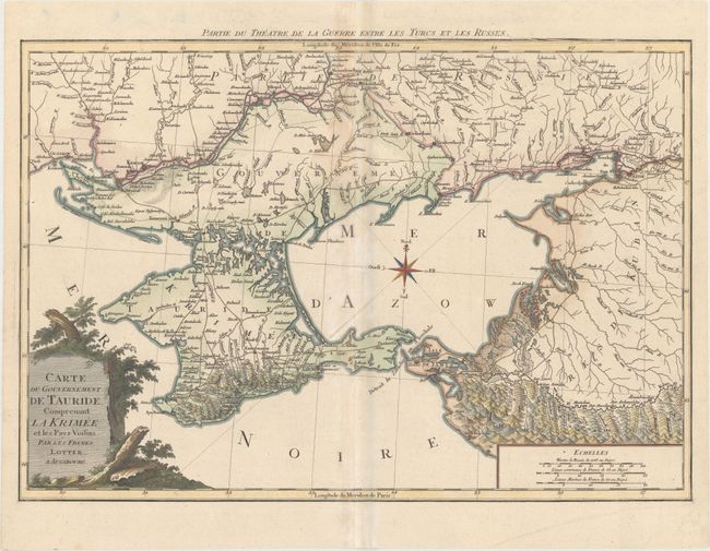
Auction 176, Lot 505
Subject: Black Sea, Ukraine & Russia
Lotter, Mathias Albrecht
Carte du Gouvernement de Tauride, Comprenant la Krimee et les Pays Voisins, 1790
Size: 24.9 x 17.1 inches (63.2 x 43.4 cm)
Estimate: $550 - $650
Russian Control Over the Crimean Peninsula - 200 Years Ago
Sold for: $400
Closed on 2/12/2020
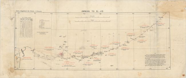
Auction 176, Lot 570
Subject: Jordan & Iraq
Amman to El Jid, 1921
Size: 34.8 x 12.8 inches (88.4 x 32.5 cm)
Estimate: $275 - $375
Rare "Lap Map" Air Navigation Map
Sold for: $200
Closed on 2/12/2020
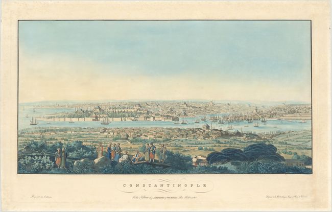
Auction 176, Lot 572
Subject: Constantinople, Turkey
Artaria, Carlo
Constantinople, 1820
Size: 28.3 x 14.8 inches (71.9 x 37.6 cm)
Estimate: $4,000 - $5,000
Very Rare View of Constantinople
Sold for: $2,750
Closed on 2/12/2020
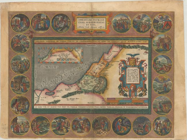
Auction 176, Lot 575
Subject: Holy Land
Ortelius, Abraham
Abrahami Patriarchae Peregrinatio, et Vita, 1586
Size: 18.3 x 14 inches (46.5 x 35.6 cm)
Estimate: $1,500 - $1,800
Elaborate Map of the Holy Land, Illustrating the Life of Abraham
Unsold
Closed on 2/12/2020
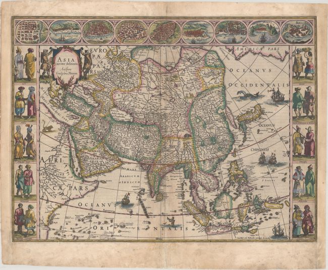
Auction 176, Lot 604
Subject: Asia
Blaeu, Willem
Asia Noviter Delineata, 1635
Size: 21.9 x 16.3 inches (55.6 x 41.4 cm)
Estimate: $3,000 - $4,000
Magnificent Carte-a-Figures Map of Asia in Full Contemporary Color
Unsold
Closed on 2/12/2020
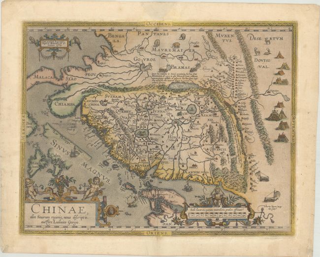
Auction 176, Lot 619
Subject: China
Ortelius, Abraham
Chinae, olim Sinarum Regionis, Nova Descriptio. Auctore Ludovico Georgio, 1584
Size: 18.4 x 14.4 inches (46.7 x 36.6 cm)
Estimate: $5,000 - $6,000
The First European-Printed Map of China in Full Contemporary Color
Sold for: $3,750
Closed on 2/12/2020
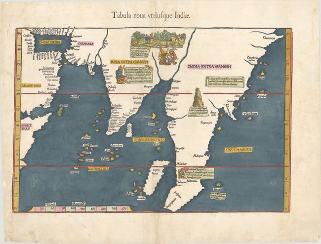
Auction 176, Lot 634
Subject: Southern Asia
Ptolemy/Fries
Tabula Nova Utriusque Indiae, 1541
Size: 17.6 x 11.7 inches (44.7 x 29.7 cm)
Estimate: $2,000 - $2,400
Early Map Depicting Southern and Southeast Asia
Sold for: $1,200
Closed on 2/12/2020
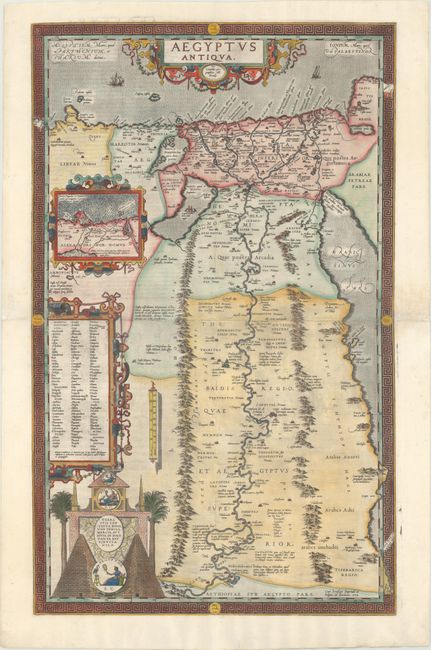
Auction 176, Lot 664
Subject: Egypt
Ortelius, Abraham
Aegyptus Antiqua, 1584
Size: 19.3 x 31.3 inches (49 x 79.5 cm)
Estimate: $2,200 - $2,750
Ortelius' Rare Two-Sheet Map of Egypt
Sold for: $1,700
Closed on 2/12/2020
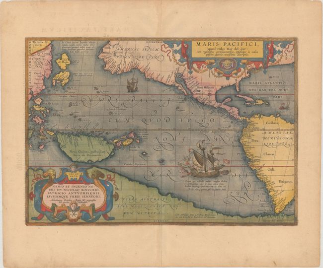
Auction 176, Lot 682
Subject: Pacific Ocean, Western Hemisphere
Ortelius, Abraham
Maris Pacifici, (quod Vulgo Mar del Zur), cum Regionibus Circumiacentibus, Insulisque in Eodem Passim Sparsis, Novissima Descriptio, 1589
Size: 19.6 x 13.6 inches (49.8 x 34.5 cm)
Estimate: $7,500 - $9,000
The First Printed Map Devoted to the Pacific in Full Contemporary Color
Sold for: $5,500
Closed on 2/12/2020
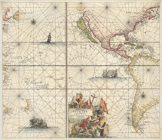
Auction 176, Lot 683
Subject: Pacific Ocean, Western Hemisphere
Keulen, Johannes van
Pascaert vande Zuyd Zee en een Gedeelte van Brasil van Ilhas de Ladronos tot R. de la Plata, 1680
Size: 23.6 x 20.4 inches (59.9 x 51.8 cm)
Estimate: $4,000 - $5,000
Superb Sea Chart of the Pacific with the Island of California
Sold for: $6,000
Closed on 2/12/2020
58 lots
Page 1 of 2