Subject: Western Hemisphere - America
Period: 1646 (dated)
Publication: Theatre Geographique de France
Color: Hand Color
Size:
19.4 x 14.8 inches
49.3 x 37.6 cm
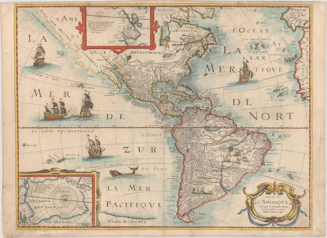
Scarce, reduced scale derivative of Hondius' influential map of 1618 by Petrus Bertius, here in the third state, published by Mariette. The map improves on Hondius by completing the coastline of Tierra del Fuego. California is still shown as a peninsula, although the Baja Peninsula is now isolated by two oddly crossed rivers, opening the possibility that it may be an island. The western coast of America is only a suggestion with a dotted line, and a note that it has not yet been discovered (Pays non Encore Des Couvertes). There is a large lake in New Mexico, surrounded by the legendary Seven Cities of Cibola, here noted as Sept Cevola. The Great Lakes are only suggested, and the region of New England is named Norumbega. South America has tiny engraved natives and trees, and two large lakes, Eupana and Parime are shown in the interior. There are insets of both the North and South Poles. The South Pole is a large continent, with two places noted; Beach Province, from the reports of Marco Polo, and Pays des Paroquets (Country of the Parakeets). The North Pole has the typical cartography of the time, with a bit of information from James and Hudson's expeditions shown. A number of ships and a sea monster patrol the seas.
References: Burden #209.
Condition: B+
An attractive example on paper with a bunch of grapes watermark, light soiling, an archivally repaired centerfold separation at bottom, and a couple of printer's creases to the left of the centerfold.