Showing Featured Lots(remove filter)
Showing results for:Auction 167
Catalog Archive
51 lots
Page 1 of 2
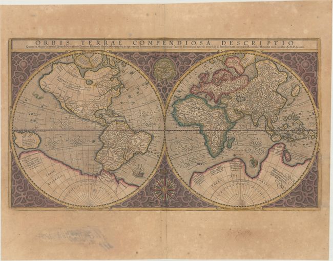
Auction 167, Lot 5
Subject: World
Mercator, Rumold
Orbis Terrae Compendiosa Descriptio quam ex Magna Universali Gerardi Mercatoris..., 1587
Size: 20.5 x 11.3 inches (52.1 x 28.7 cm)
Estimate: $3,750 - $4,500
Mercator's Double-Hemisphere World Map in Full Contemporary Color
Unsold
Closed on 3/28/2018
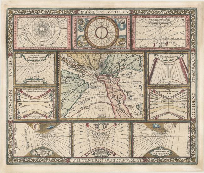
Auction 167, Lot 7
Subject: World
Ritter, Franz
[Untitled - World and Horological Diagrams], 1607
Size: 13.6 x 11.2 inches (34.5 x 28.4 cm)
Estimate: $3,500 - $4,500
Ritter's Unusual Sun-Dial World Map - First State
Unsold
Closed on 3/28/2018
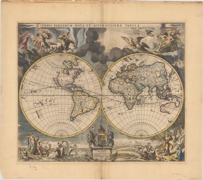
Auction 167, Lot 8
Subject: World
Pitt, Moses
Orbis Terrarum Nova et Accuratissima Tabula, 1680
Size: 20.9 x 17.5 inches (53.1 x 44.5 cm)
Estimate: $4,000 - $4,750
Pitt's Superb Double-Hemisphere World Map
Sold for: $2,750
Closed on 3/28/2018
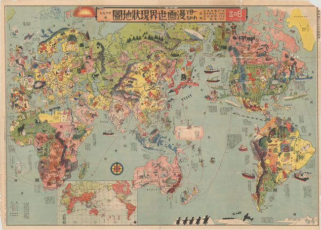
Auction 167, Lot 16
Subject: World
[At a Glance: Cartoon Map of the Current World Situation] Hitome de Wakaru Manga Sekai Manga Genjo Chizu..., 1932
Size: 42 x 29.8 inches (106.7 x 75.7 cm)
Estimate: $1,400 - $2,000
Fascinating Japanese Satirical Map Published Prior to WWII
Sold for: $4,000
Closed on 3/28/2018
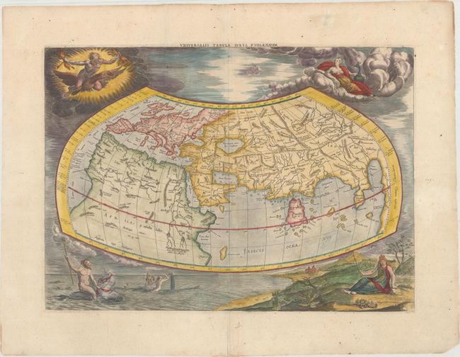
Auction 167, Lot 19
Subject: Ancient World
Ptolemy/Mercator
Universalis Tabula Iuxta Ptolemaeum, 1695
Size: 18.6 x 13.4 inches (47.2 x 34 cm)
Estimate: $1,600 - $2,000
Ancient Map of the World with Depictions of the Four Elements
Sold for: $1,400
Closed on 3/28/2018
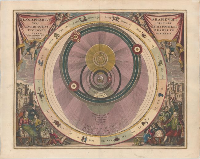
Auction 167, Lot 28
Subject: Solar System
Cellarius/Schenk & Valck
Planisphaerium Braheum, sive Structura Mundi Totius, ex Hypothesi Tychonis Brahei in Plano Delineata, 1708
Size: 19.7 x 15.8 inches (50 x 40.1 cm)
Estimate: $1,600 - $2,000
Chart Depicting Tycho Brahe's Model of the Universe
Sold for: $1,100
Closed on 3/28/2018
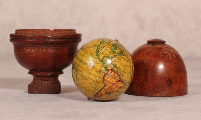
Auction 167, Lot 30
Subject: Miniature Globe
Newton, J. & Sons
[2" Miniature Globe] Newtons New & Improved Terrestrial Globe Containing the Latest Dist., 1833
Size: 8 x 4.5 inches (20.3 x 11.4 cm)
Estimate: $3,500 - $4,500
The Whole World in Your Hands
Sold for: $2,500
Closed on 3/28/2018
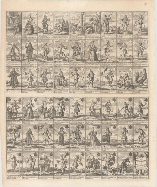
Auction 167, Lot 32
Subject: Cartographic Miscellany, Playing Cards
Anon.
Pasquins Windkaart. Op de Windnegotie, 1720
Size: 17.3 x 20.3 inches (43.9 x 51.6 cm)
Estimate: $1,600 - $1,900
Sheet of Playing Cards Satirizing the Mississippi Bubble
Sold for: $1,200
Closed on 3/28/2018
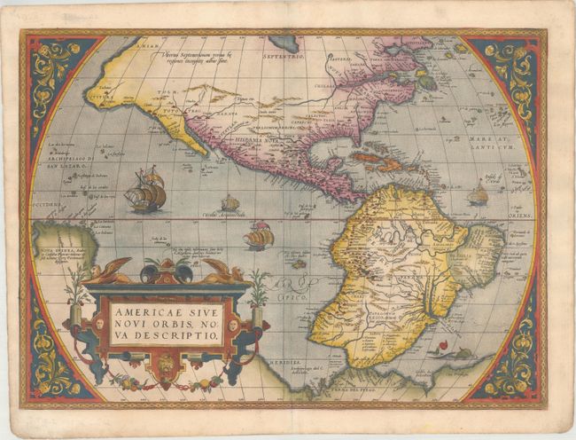
Auction 167, Lot 36
Subject: Western Hemisphere - America
Ortelius, Abraham
Americae sive Novi Orbis, Nova Descriptio, 1570
Size: 20.1 x 14.4 inches (51.1 x 36.6 cm)
Estimate: $5,500 - $7,000
Rare First Plate, First Edition of Ortelius' Influential Map of the New World
Sold for: $4,500
Closed on 3/28/2018
Auction 167, Lot 38
Subject: Western Hemisphere - America
Hondius, Jodocus
America, 1623
Size: 19.9 x 14.8 inches (50.5 x 37.6 cm)
Estimate: $4,000 - $4,750
Hondius' Important Map of the Americas in Full Contemporary Color
Unsold
Closed on 3/28/2018
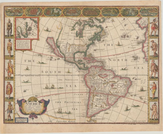
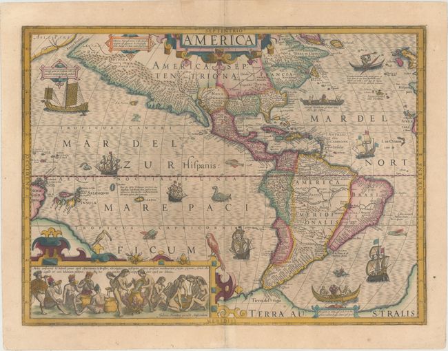
Auction 167, Lot 39
Subject: Western Hemisphere - America
Speed, John
America with Those Known Parts in That Unknowne Worlde Both People and Manner of Buildings , 1626
Size: 20.4 x 15.6 inches (51.8 x 39.6 cm)
Estimate: $4,500 - $6,000
Speed's Popular Carte-a-Figures Map of the Americas
Sold for: $2,750
Closed on 3/28/2018
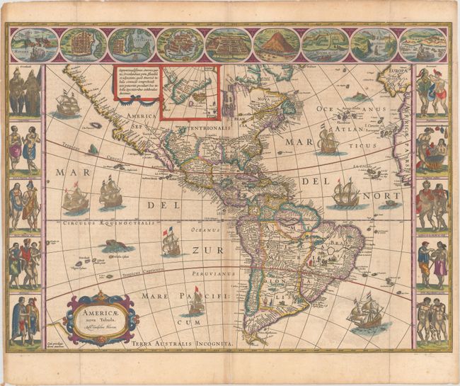
Auction 167, Lot 40
Subject: Western Hemisphere - America
Blaeu, Willem
Americae Nova Tabula, 1640
Size: 21.9 x 16.3 inches (55.6 x 41.4 cm)
Estimate: $5,500 - $6,500
Blaeu's Stunning Carte-a-Figures Map of the Americas in Full Contemporary Color
Unsold
Closed on 3/28/2018
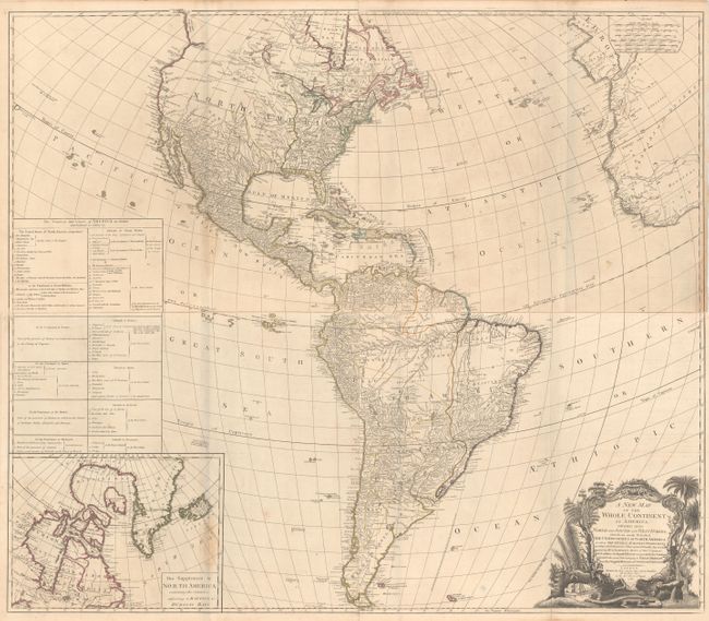
Auction 167, Lot 44
Subject: Western Hemisphere - America
Sayer, Robert
[On 4 Sheets] A New Map of the Whole Continent of America. Divided Into North and South and West Indies. Wherein Are Exactly Described the United States of North America..., 1786
Size: 46.8 x 20.3 inches (118.9 x 51.6 cm)
Estimate: $1,100 - $1,400
Impressive Four-Sheet Map Featuring Two Possible Locations for a River of the West
Sold for: $650
Closed on 3/28/2018
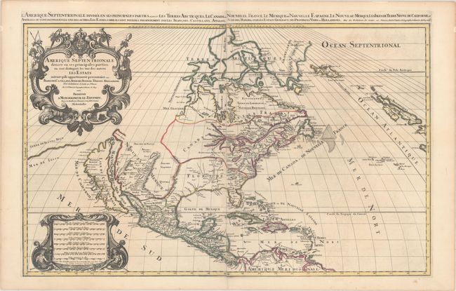
Auction 167, Lot 47
Subject: Colonial North America
Sanson/Mortier
Amerique Septentrionale Divisee en ses Principales Parties, ou sont Distingues les uns des Autres les Estats..., 1696
Size: 34.4 x 21.4 inches (87.4 x 54.4 cm)
Estimate: $2,500 - $3,500
Two-Sheet Map Showing the Island of California
Sold for: $1,600
Closed on 3/28/2018
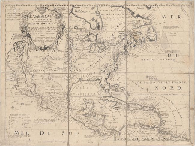
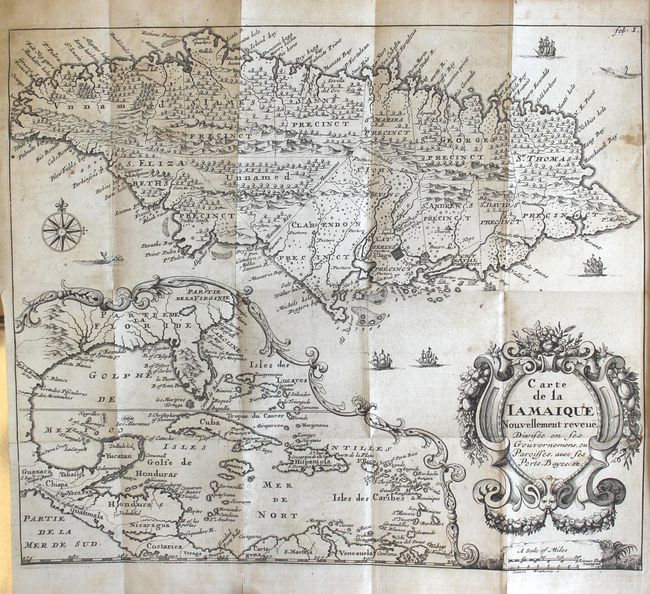
Auction 167, Lot 48
Subject: Colonial North America
Coronelli/Nolin
L'Amerique Septentrionale, ou la Partie Septentrionale des Indes Occidentales ou se Trouve le Canada ou Nouvelle France la Floride la Virginie les Isles Antilles..., 1704
Size: 23.3 x 17.6 inches (59.2 x 44.7 cm)
Estimate: $2,400 - $3,000
Nolin's Spectacular Version of Coronelli's Map of North America
Sold for: $1,800
Closed on 3/28/2018
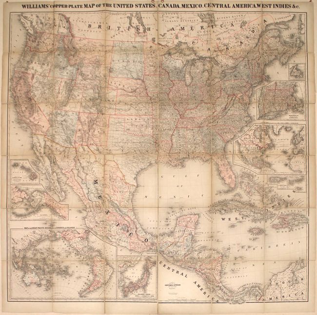
Auction 167, Lot 57
Subject: North America
Williams' Copper-Plate Map of the United States, Canada, Mexico, Central America, West Indies &c., 1876
Size: 63.1 x 61.9 inches (160.3 x 157.2 cm)
Estimate: $1,800 - $2,100
Rare Wall Map of North America
Unsold
Closed on 3/28/2018
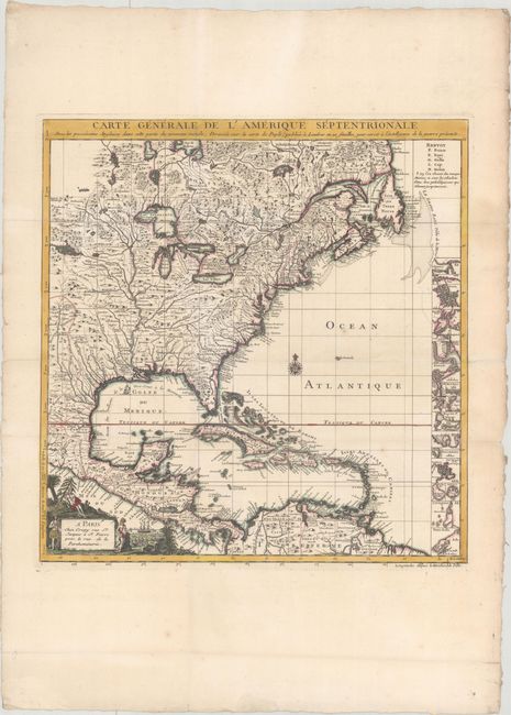
Auction 167, Lot 59
Subject: Colonial Eastern North America & West Indies
Crepy, (Family)
Carte Generale de l'Amerique Septentrionale avec les Possessions Angloises dans Cette Partie du Nouveau Monde, Dressee sur la Carte de Pople..., 1756
Size: 19.4 x 20.2 inches (49.3 x 51.3 cm)
Estimate: $1,800 - $2,100
French Index Sheet of Popple's Map
Sold for: $1,000
Closed on 3/28/2018
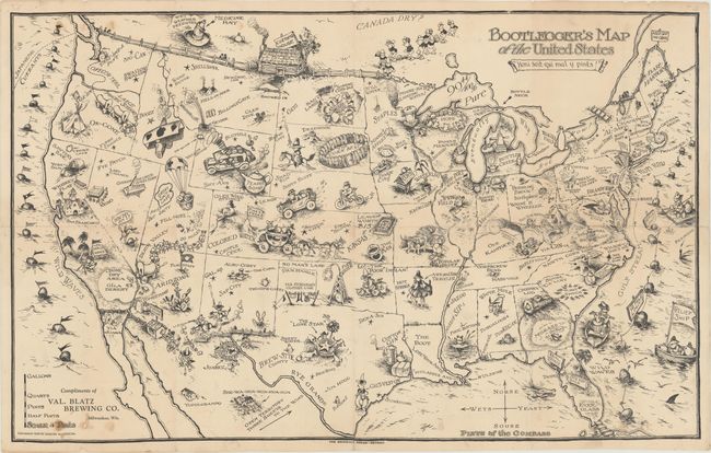
Auction 167, Lot 83
Subject: United States
Bootlegger's Map of the United States , 1926
Size: 33.9 x 21.3 inches (86.1 x 54.1 cm)
Estimate: $500 - $650
McCandlish's Humorous Prohibition Map
Sold for: $350
Closed on 3/28/2018
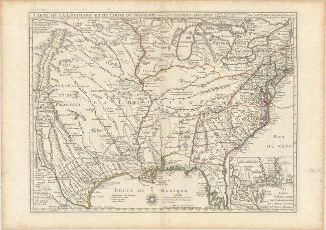
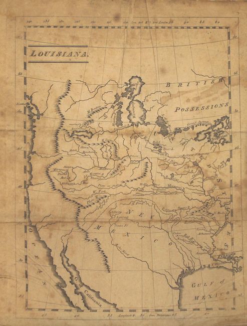
Auction 167, Lot 86
Subject: Colonial Eastern United States, Louisiana Territory
Delisle/Dezauche
Carte de la Louisiane et du Cours du Mississipi avec les Colonies Anglaises, 1782
Size: 25.4 x 19.1 inches (64.5 x 48.5 cm)
Estimate: $1,600 - $1,900
Delisle's Influential Map of the Louisiana Territory
Unsold
Closed on 3/28/2018
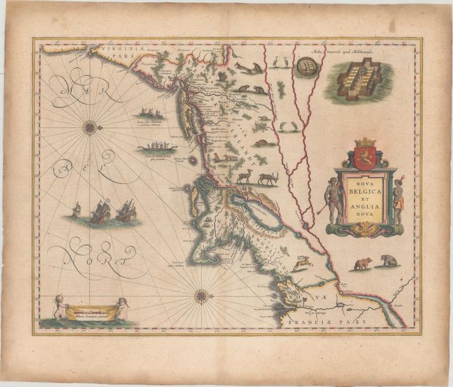
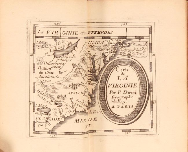
Auction 167, Lot 95
Subject: Colonial New England & Mid-Atlantic United States
Blaeu, Willem
Nova Belgica et Anglia Nova, 1638
Size: 19.9 x 15.3 inches (50.5 x 38.9 cm)
Estimate: $2,300 - $2,750
Important Map of Colonial New England and the Mid-Atlantic
Unsold
Closed on 3/28/2018
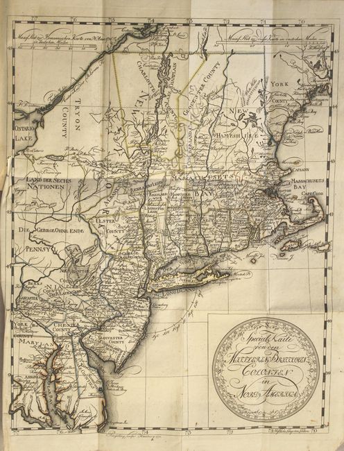
Auction 167, Lot 97
Subject: Colonial New England & Mid-Atlantic United States
Leiste/Pingeling
Special Karte von den Mittleren Britisshen Colonien in Nord Amerika... [bound in] Beschreibung des Brittischen Amerika zur Ersparung der Englischen Karten..., 1778
Size: 11.7 x 14.8 inches (29.7 x 37.6 cm)
Estimate: $1,800 - $2,100
Scarce Revolutionary War Map
Unsold
Closed on 3/28/2018
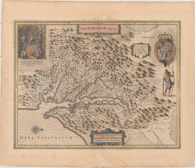
Auction 167, Lot 99
Subject: Colonial Mid-Atlantic United States
Hondius, Henricus
Nova Virginiae Tabula, 1636
Size: 19.5 x 15.1 inches (49.5 x 38.4 cm)
Estimate: $1,800 - $2,200
One of the Most Important 17th Century Maps of the Chesapeake Bay
Sold for: $1,000
Closed on 3/28/2018
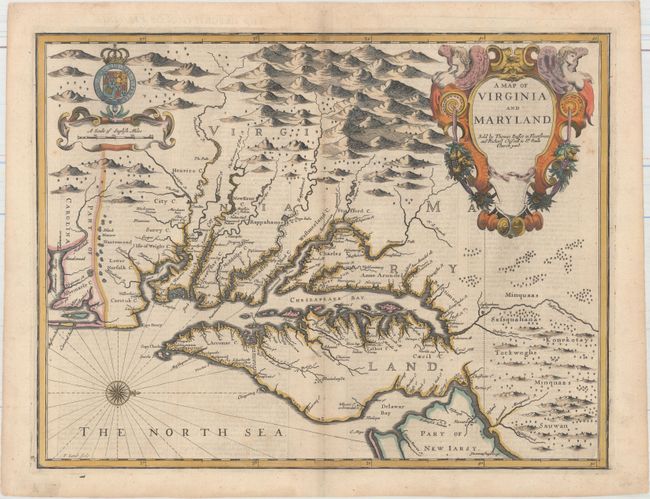
Auction 167, Lot 100
Subject: Colonial Mid-Atlantic United States
Speed/Lamb
A Map of Virginia and Maryland, 1676
Size: 19.4 x 14.9 inches (49.3 x 37.8 cm)
Estimate: $4,000 - $5,000
The First Printed Map to Draw Upon the Legendary Herrman Map of the Chesapeake Bay
Sold for: $3,000
Closed on 3/28/2018
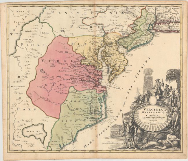
Auction 167, Lot 101
Subject: Colonial Mid-Atlantic United States
Homann, Johann Baptist
Virginia Marylandia et Carolina in America Septentrionali Britannorum Industria Excultae, 1714
Size: 23.1 x 19.3 inches (58.7 x 49 cm)
Estimate: $1,200 - $1,500
Map Created to Promote German Immigration to the New World
Sold for: $800
Closed on 3/28/2018
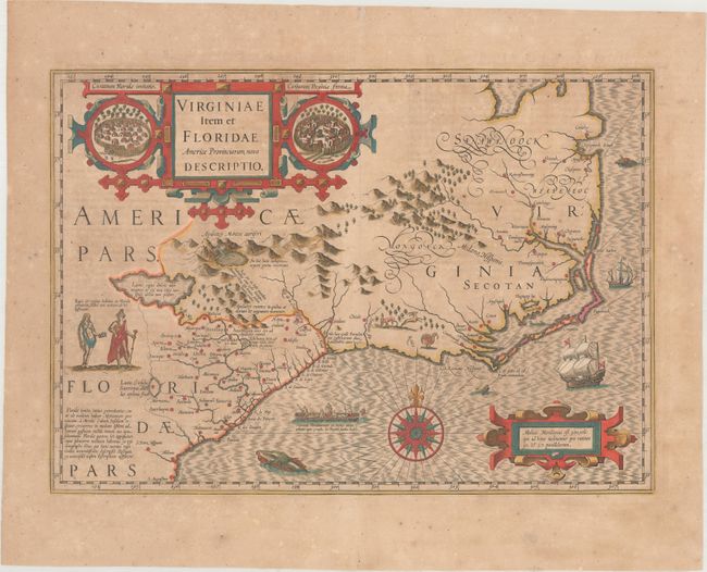
Auction 167, Lot 104
Subject: Colonial Southeastern United States
Hondius, Jodocus
Virginiae Item et Floridae Americae Provinciarum, Nova Descriptio, 1639
Size: 19.1 x 13.4 inches (48.5 x 34 cm)
Estimate: $1,600 - $1,900
A Seminal Map of the Southeast and Early American Cartography - Full Contemporary Color
Sold for: $1,200
Closed on 3/28/2018
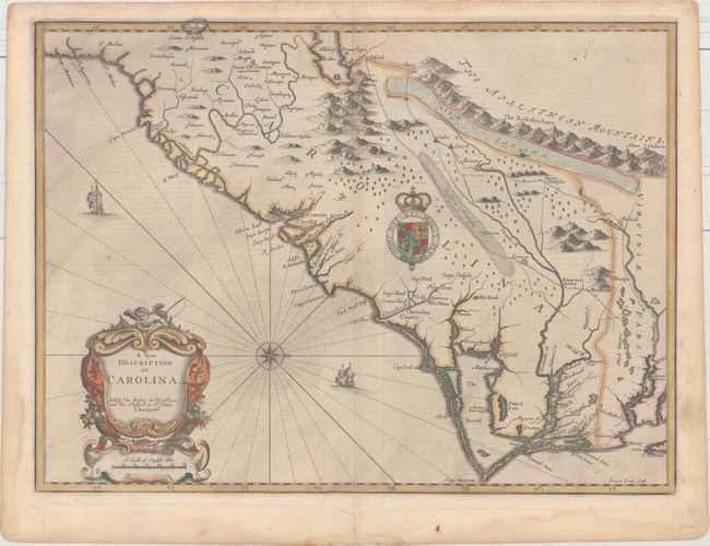
Auction 167, Lot 105
Subject: Colonial Southeastern United States
Speed/Lamb
A New Description of Carolina, 1676
Size: 20 x 14.8 inches (50.8 x 37.6 cm)
Estimate: $3,500 - $4,250
Speed's Map of the Carolinas Based Upon the Lords Proprietor's Map
Unsold
Closed on 3/28/2018
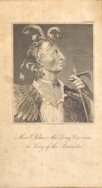
Auction 167, Lot 109
Subject: Southeastern United States
Bartram, William
Travels Through North and South Carolina, Georgia, East and West Florida, the Cherokee Country, the Extensive Territories of the Muscogulges or Creek Confederacy, and the Country of the Chactaws..., 1793
Size: 5.5 x 8.3 inches (14 x 21.1 cm)
Estimate: $2,750 - $3,500
Irish Edition of Bartram's Work on the Southeast
Unsold
Closed on 3/28/2018
Auction 167, Lot 124
Subject: Western United States
Gass, Patrick
Journal of the Voyages and Travels of a Corps of Discovery, Under the Command of Capt. Lewis and Capt. Clarke of the Army of the United States..., 1812
Size: 4.6 x 7.3 inches (11.7 x 18.5 cm)
Estimate: $5,500 - $7,000
Fourth Edition of the Earliest First-Hand Narrative of the Lewis & Clark Expedition
Sold for: $4,000
Closed on 3/28/2018
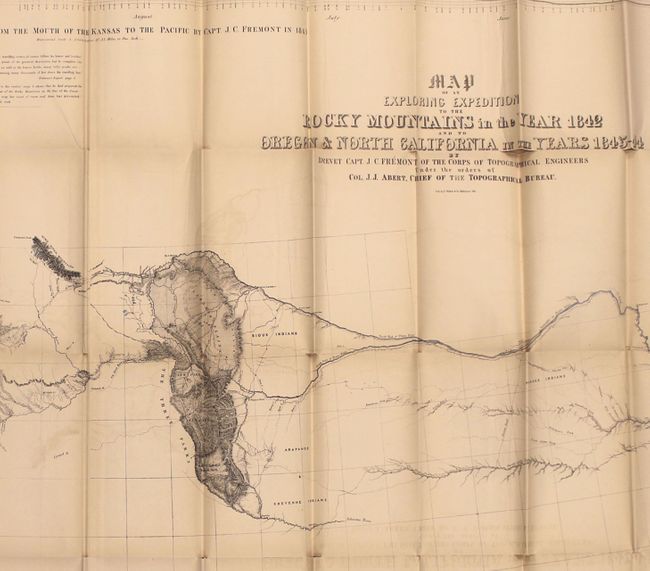
Auction 167, Lot 125
Subject: Western United States
Fremont/Preuss
Map of an Exploring Expedition to the Rocky Mountains in the Year 1842 and to Oregon & North California in the Years 1843-44 [with] Report of The Exploring Expedition to the Rocky Mountains…, 1845
Size: 51 x 30.5 inches (129.5 x 77.5 cm)
Estimate: $1,100 - $1,400
Fremont's Large Map of the American West
Unsold
Closed on 3/28/2018
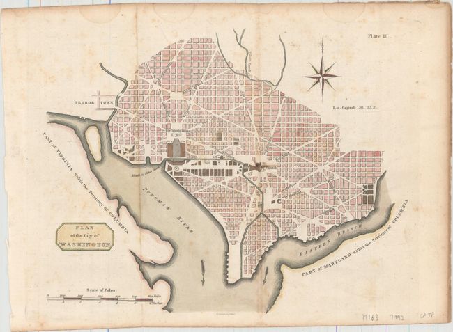
Auction 167, Lot 138
Subject: Washington, D.C.
Plan of the City of Washington, 1805
Size: 10.6 x 8.3 inches (26.9 x 21.1 cm)
Estimate: $1,200 - $1,500
Rare Scottish Plan of Washington
Unsold
Closed on 3/28/2018
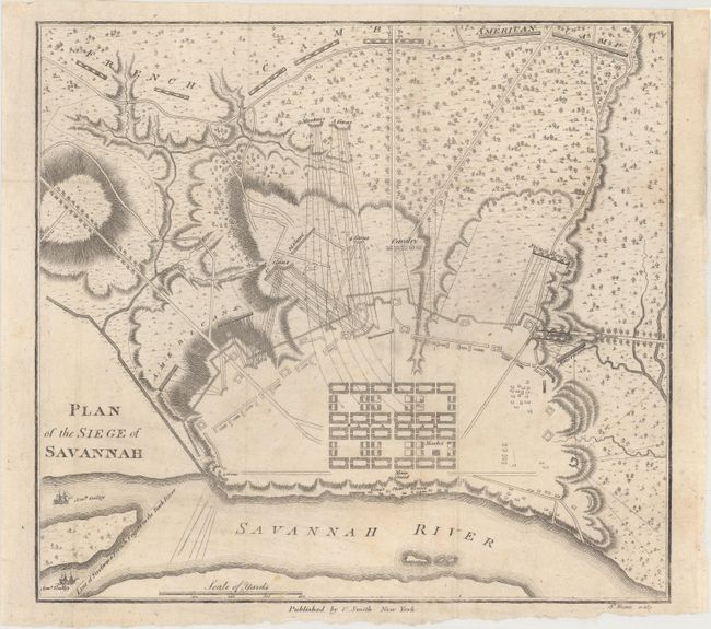
Auction 167, Lot 150
Subject: Savannah, Georgia, Revolutionary War
Smith, Charles
Plan of the Siege of Savannah, 1796
Size: 9.1 x 8.4 inches (23.1 x 21.3 cm)
Estimate: $2,000 - $2,300
Rare Revolutionary War Plan Showing the Siege of Savannah
Unsold
Closed on 3/28/2018
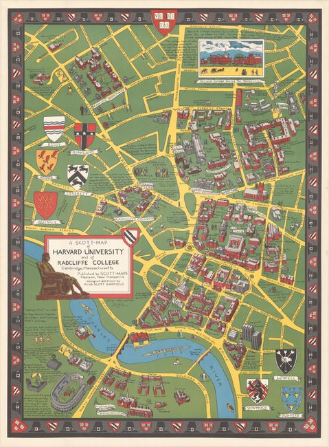
Auction 167, Lot 160
Subject: Massachusetts & New Hampshire
[Lot of 5] A Scott-Map of Harvard University and of Radcliffe College... [and] ... Boston Massachusetts [and] ... Concord Massachusetts... [and] ... the White Mountains of New Hampshire [and] Salem Massachusetts..., 1949-60
Size: See Description
Estimate: $350 - $450
A Wonderful Set of "Scott Maps"
Sold for: $375
Closed on 3/28/2018
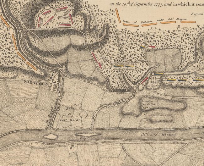
Auction 167, Lot 175
Subject: Colonial Saratoga, New York, Revolutionary War
Faden, William
Plan of the Position Which the Army Under Lt. Genl. Burgoine Took at Saratoga on the 10th of September 1777, and In Which It Remained Till the Convention Was Signed, 1780
Size: 18.7 x 8.6 inches (47.5 x 21.8 cm)
Estimate: $1,400 - $1,700
Important Revolutionary War Map of the 2nd Battle of Saratoga
Unsold
Closed on 3/28/2018
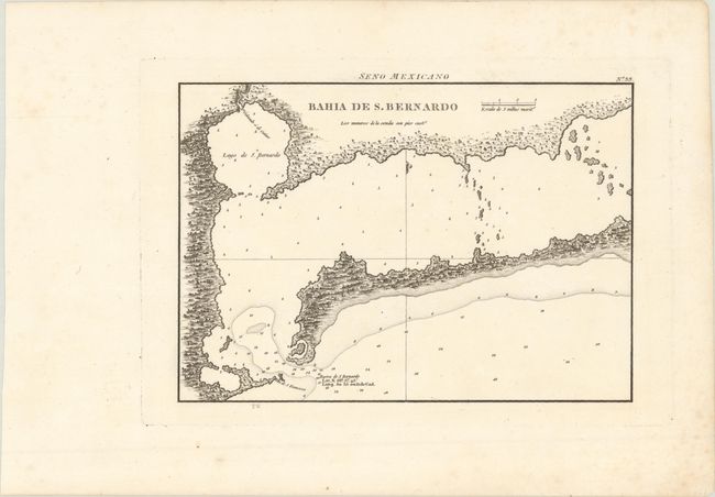
Auction 167, Lot 188
Subject: Matagorda Bay, Texas
Direccion de Hidrografia
Bahia de S. Bernardo, 1809
Size: 10.2 x 7.2 inches (25.9 x 18.3 cm)
Estimate: $550 - $700
First Engraved Map of Matagorda Bay
Sold for: $300
Closed on 3/28/2018
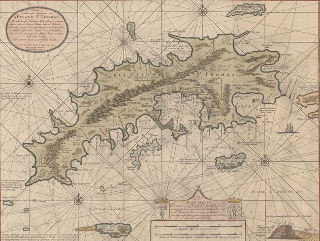
Auction 167, Lot 224
Subject: St. Thomas, US Virgin Islands
Keulen, Gerard van
Nieuwe en Aldereerste Afteekening van 't Eyland St. Thomas. Met alle Desselfs Havenen, Anker Plaatse..., 1719
Size: 39.3 x 23.4 inches (99.8 x 59.4 cm)
Estimate: $4,000 - $5,000
One of the Earliest Maps of St. Thomas
Unsold
Closed on 3/28/2018
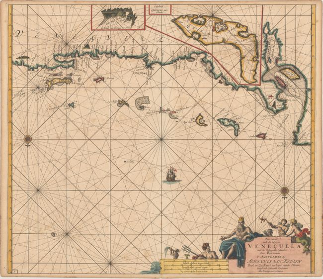
Auction 167, Lot 233
Subject: Venezuela
Keulen/Vooght
Pas-kaart vande Zee Kusten van Venecuela met de Byleggende Eylanden, 1700
Size: 23.1 x 20.2 inches (58.7 x 51.3 cm)
Estimate: $1,100 - $1,400
Superb Early Chart of the Venezuelan Coastline Including the ABC Islands
Unsold
Closed on 3/28/2018
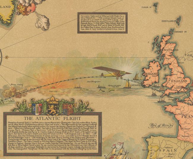
Auction 167, Lot 252
Subject: North America & North Atlantic
Map Showing the Overland and Overseas Flights of Charles A. Lindbergh Colonel and Flight Comdr. 110th Observation Sqdn. Missouri Nat. Guard, 1928
Size: 46 x 26.3 inches (116.8 x 66.8 cm)
Estimate: $1,400 - $1,800
Impressive Wall Map Chronicling Lindbergh's Career in Aviation
Sold for: $1,000
Closed on 3/28/2018
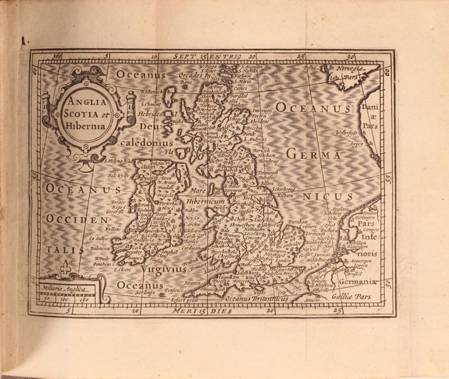
Auction 167, Lot 259
Subject: Britain
Camden, William
Guili. Camdeni Viri Clarissimi Britannia, sive Florentiss. Regnorum Angliae, Scotiae, Hiberniae..., 1639
Size: 3.1 x 5.5 inches (7.9 x 14 cm)
Estimate: $1,400 - $1,700
Miniature Version of Camden's Britannia Published by Blaeu
Sold for: $1,500
Closed on 3/28/2018
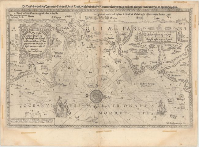
Auction 167, Lot 263
Subject: Southeastern England
Waghenaer, Lucas Jansz
De Zee Custen Tuschen Dovere en Orfordts Nesse, Daer de Teemse de Vermaerde Rivire va Lonen Gelegens is, met Alle Sanden Ondiepte, Naer Haren Wesen en Ghedaente, 1589
Size: 19.9 x 12.8 inches (50.5 x 32.5 cm)
Estimate: $1,600 - $2,000
Rare and Early Sea Chart of the English Coast Near Dover
Unsold
Closed on 3/28/2018
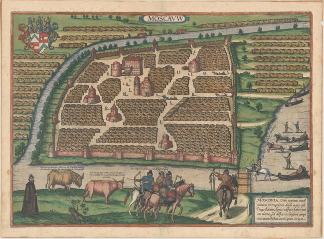
Auction 167, Lot 318
Subject: Moscow, Russia
Braun & Hogenberg
Moscauw, 1575
Size: 19.3 x 13.8 inches (49 x 35.1 cm)
Estimate: $2,750 - $3,500
Braun & Hogenberg's First Plan of Moscow in Contemporary Color
Sold for: $2,750
Closed on 3/28/2018
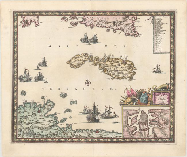
Auction 167, Lot 346
Subject: Malta
Wit, Frederick de
Insula Malta Accuratissime Delineata, Urbibus, et Fortalitiis, 1680
Size: 21.5 x 17.6 inches (54.6 x 44.7 cm)
Estimate: $1,200 - $1,500
One of the Most Decorative 17th Century Maps of Malta
Sold for: $900
Closed on 3/28/2018
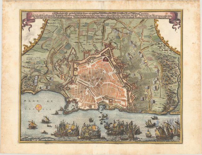
Auction 167, Lot 348
Subject: Candia, Crete
Hoffman, Johannes
Geometrisch-Grundrichtige Zuvor nie Gesehne Abbildung der Welt Beruffene Real-Vestung Candia, 1670
Size: 19.3 x 15.9 inches (49 x 40.4 cm)
Estimate: $1,200 - $1,500
Rare Engraving of the Siege of Candia
Unsold
Closed on 3/28/2018
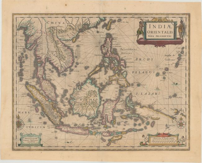
Auction 167, Lot 381
Subject: Southeast Asia
Jansson, Jan
Indiae Orientalis Nova Descriptio, 1646
Size: 19.8 x 15.3 inches (50.3 x 38.9 cm)
Estimate: $1,400 - $1,700
Includes Discoveries Made by the Dutch "Duyfken" Exploration
Unsold
Closed on 3/28/2018
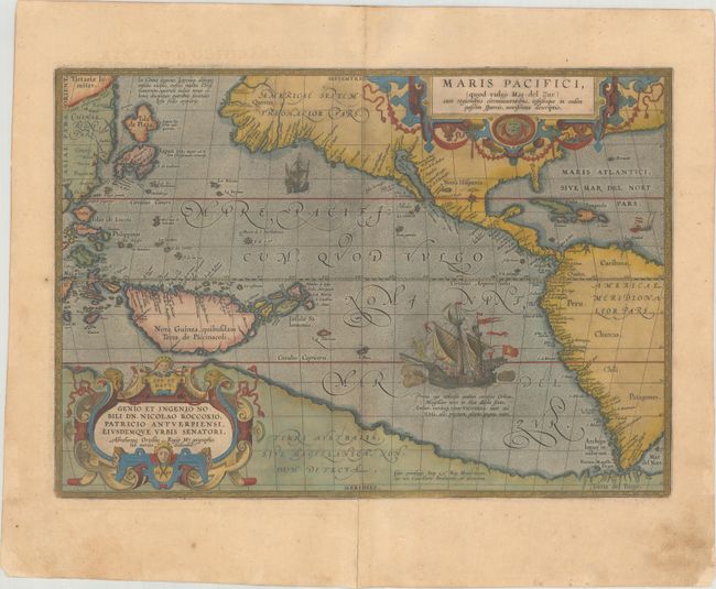
Auction 167, Lot 412
Subject: Pacific Ocean
Ortelius, Abraham
Maris Pacifici, (quod Vulgo Mar del Zur) cum Regionibus Circumiacentibus, Insulisque in Eodem Passim Sparsis, Novissima Descriptio, 1589
Size: 19.4 x 13.4 inches (49.3 x 34 cm)
Estimate: $8,000 - $10,000
The First Printed Map Devoted to the Pacific in Full Contemporary Color
Unsold
Closed on 3/28/2018
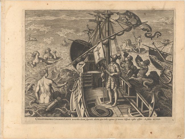
Auction 167, Lot 425
Subject: Prints - Exploration
Stradanus, Joannes
[Lot of 3] Christophorus Columbus Ligur... [and] Americus Vespuccius Florentinus... [and] Ferdinandes Magalanes Lusitanus..., 1592
Size: 11.1 x 7.8 inches (28.2 x 19.8 cm)
Estimate: $1,900 - $2,300
Rare Set of Celebrated Explorers of the New World
Sold for: $1,400
Closed on 3/28/2018
Auction 167, Lot 436
Subject: Atlases
Duval, Pierre
La Geographie Universelle qui fait voir l'Estat Present des 4 Parties du Monde, c'est a Dire, les Religions, les Coutumes et les Richesses des Peuples... [bound with] Le Monde Chrestien ou Sont les Cartes des Archveschez et des Eveschez de l'Univers, 1682
Size: 4.3 x 6.3 inches (10.9 x 16 cm)
Estimate: $5,500 - $7,500
Two Superb Miniature Atlases Bound in One Volume with 98 Maps
Sold for: $3,750
Closed on 3/28/2018
Auction 167, Lot 440
Subject: Geography Books
Blome, Richard
Description des Isles et Terres que l'Angleterre Possede en Amerique avec de Nouvelles Cartes de Chaque Isle && des Terres, 1715
Size: 3.8 x 6.1 inches (9.7 x 15.5 cm)
Estimate: $1,800 - $2,100
French Edition of Blome's Work on British Colonial Interests in North America with 6 Maps
Sold for: $1,200
Closed on 3/28/2018
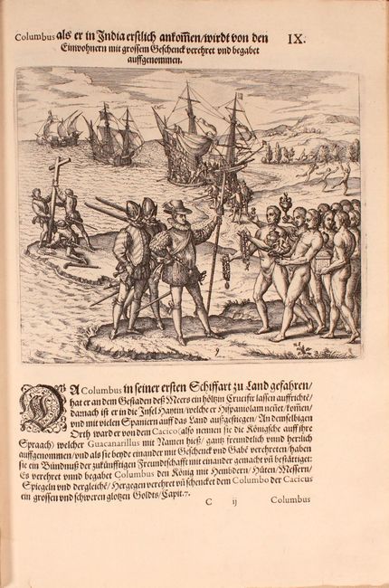
Auction 167, Lot 445
Subject: Exploration & Surveys
Bry, Theodore de
[Grands Voyages, Part IV] Das Vierdte Buch von der Neuwen Welt. Oder Neuwe und Grundtliche Historien/ von dem Nidergangishcen Indien/ so von Christophoro Columbo im Jar 1492..., 1613
Size: 9.4 x 13.9 inches (23.9 x 35.3 cm)
Estimate: $2,000 - $2,500
Part IV of Grand Voyages by Girolamo Benzoni with 29 Engravings
Sold for: $3,750
Closed on 3/28/2018
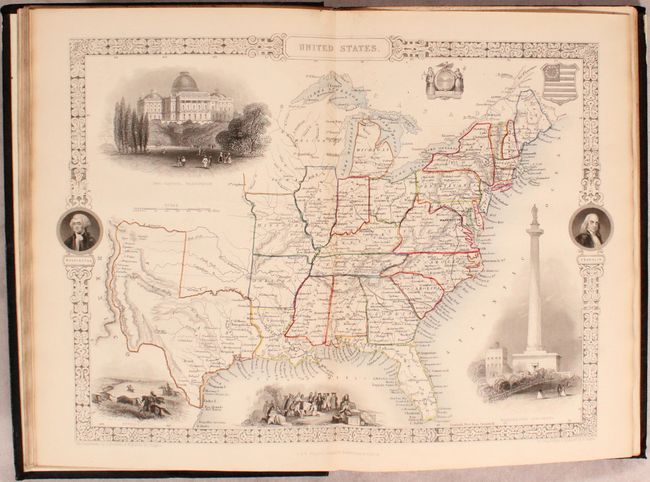
Auction 167, Lot 447
Subject: History Books
Tallis, John
[6 Volumes with Maps & Plates] History of the United States of America, From the Earliest Period to the Present Time, 1850
Size: 7.8 x 11.4 inches (19.8 x 29 cm)
Estimate: $1,500 - $1,800
Includes Several Uncommon Tallis Maps
Sold for: $1,700
Closed on 3/28/2018
Auction 167, Lot 448
Subject: Miscellaneous Books, Europe
Mallet, Alain Manesson
Les Travaux de Mars ou la Fortification Nouvelle tant Reguliere..., 1672
Size: 4.9 x 8 inches (12.4 x 20.3 cm)
Estimate: $1,400 - $1,700
Mallet's Military Masterpiece
Sold for: $1,000
Closed on 3/28/2018
51 lots
Page 1 of 2