Subject: World
Period: 1680 (circa)
Publication: English Atlas
Color: Hand Color
Size:
20.9 x 17.5 inches
53.1 x 44.5 cm
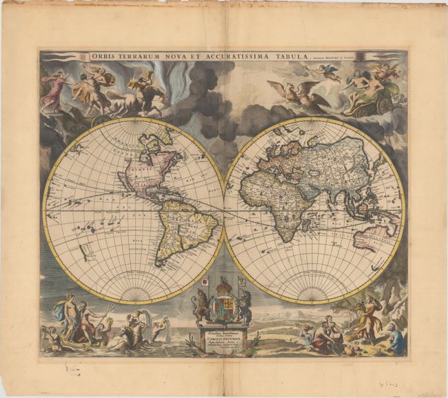
This highly decorative, double-hemisphere world map is based upon Visscher's map of 1658, with the surrounding dramatic scenes drawn by Nicolas Berchem. These superb engravings represent the abduction of Persephone by Hades, Zeus being carried across the heavens in an eagle-drawn chariot, Poseidon commanding his entourage, and Demeter receiving the fruits of the Earth. Geographically, the map is based on Blaeu's large world map of 1648 with minor variations in the island of California shown here with a flat northern coast, and Anian appearing adjacent to a strait leading within striking distance of the western shores of Hudson Bay. In China, stippling is used for the first time in a general map to denote a desert, Xamo Desertum, just west of the Great Wall.
This map was published by Jan van Loon as early as 1666, with further editions in 1667, 1668, and 1676. The present example is the second state, updated to include a dedication to Charles II along with his coat of arms, and was issued in Moses Pitt's English Atlas of 1680.
References: Shirley #439.
Condition: B+
A crisp impression on watermarked paper with light extraneous creasing adjacent to the centerfold and a short fold separation confined to the bottom blank margin that has been closed on verso with old paper. There is light mat burn along the outside edge of the map border, and remnants of paper tape on verso with some show through along the top edge of the sheet.