Subject: Washington, D.C.
Period: 1805 (circa)
Publication: Encyclopaedia Perthensis; or Universal Dictionary
Color: Hand Color
Size:
10.6 x 8.3 inches
26.9 x 21.1 cm
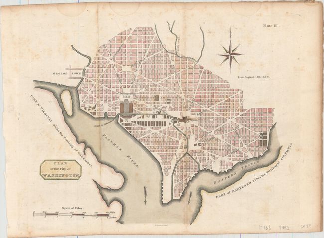
This very rare, small plan of Washington was issued in volume one of Encyclopaedia Perthensis; or Universal Dictionary, published in Scotland. It is not listed in Phillips' Maps and Views of Washington or List of Maps in the Library of Congress. While its size and configuration is very similar to the small plans of 1792 (Thackara & Vallance, Hill and Tiebout), it is a completely separate issue. Cartographically, the plan shows the layout of streets including the long diagonals, but no block numbering. Washington is bordered by the Potomak (Potomac) River and the Eastern Branch, now the Anacostia River. The proposed landscape design for the Mall is shown with only the Capitol and the Presidents House labeled. This version does not include soundings in the Potomac River, and there is no block detail in Georgetown. Decorated by a simple block-style cartouche. Below the image is the imprint of Thomas Clerk in Edinburgh. Clerk is probably best known for engraving John Thomson's New General Atlas in 1814.
References:
Condition: B+
Issued folding on paper with "1805" watermark, with light scattered foxing and several small, faint damp stains along the top edge of the sheet, not affecting image.