Showing Featured Lots(remove filter)
Showing results for:Auction 158
Catalog Archive
68 lots
Page 1 of 2
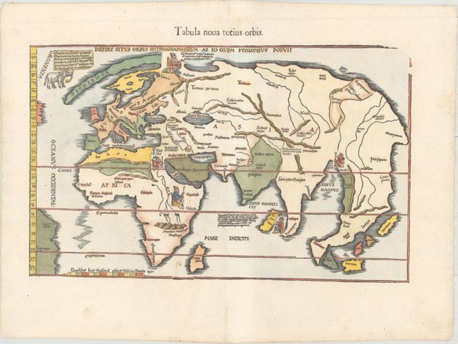
Auction 158, Lot 13
Subject: World
Ptolemy/Fries
Tabula Nova Totius Orbis, 1541
Size: 17.9 x 11.2 inches (45.5 x 28.4 cm)
Estimate: $4,000 - $5,000
"Modern" World Map with Portraits of Five Kings
Sold for: $4,250
Closed on 6/22/2016
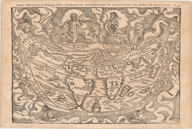
Auction 158, Lot 14
Subject: World
Apianus, Peter Bienewitz
Typus Universalis Terrae, Iuxta Modernorum Distinctionem et Extensionem per Regna et Provincias, 1583
Size: 11 x 7.6 inches (27.9 x 19.3 cm)
Estimate: $4,000 - $5,000
Apianus' Popular Cordiform World Map from the First Woodblock
Sold for: $2,750
Closed on 6/22/2016
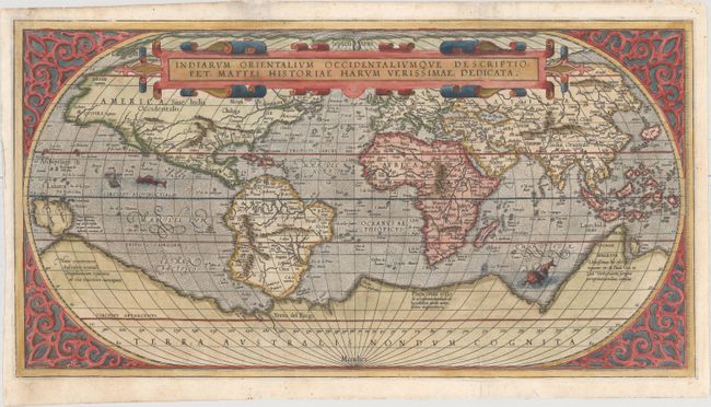
Auction 158, Lot 15
Subject: World
Maffei (Maffeius), Peter
Indiarum Orientalium Occidentaliumque Descriptio..., 1589
Size: 19.2 x 10.2 inches (48.8 x 25.9 cm)
Estimate: $4,000 - $5,000
Scarce Italian World Map Based on Ortelius
Sold for: $2,750
Closed on 6/22/2016
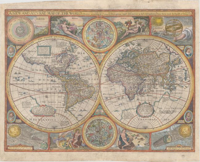
Auction 158, Lot 19
Subject: World
Speed, John
A New and Accurat Map of the World Drawne According to ye Truest Descriptions Latest Discoveries & Best Observations yt Have Beene Made by English or Strangers, 1651
Size: 20.8 x 15.6 inches (52.8 x 39.6 cm)
Estimate: $14,000 - $16,000
Speed's Double-Hemisphere World Map
Sold for: $10,500
Closed on 6/22/2016
Auction 158, Lot 20
Subject: World
Happel, Everard Werner
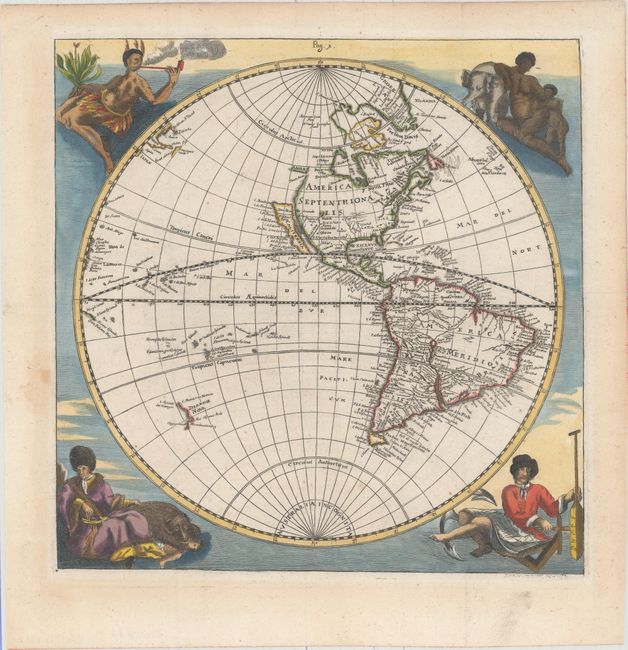
[Lot of 2 - Western Hemisphere and Eastern Hemisphere], 1687
Size: 11.3 x 11.4 inches (28.7 x 29 cm)
Estimate: $2,750 - $3,500
Striking Pair of Hemispheres with Native Figures
Sold for: $1,600
Closed on 6/22/2016
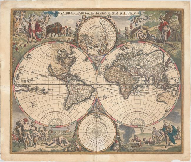
Auction 158, Lot 21
Subject: World
Wit, Frederick de
Nova Orbis Tabula, in Lucem Edita, 1688
Size: 22.4 x 18.9 inches (56.9 x 48 cm)
Estimate: $4,000 - $4,750
De Wit's Stunning Double-Hemisphere Map
Sold for: $3,000
Closed on 6/22/2016
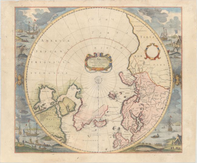
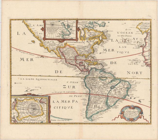
Auction 158, Lot 40
Subject: North Pole
Hondius, Henricus
Poli Arctici, et Circumiacentium Terrarum Descriptio Novissima, 1639
Size: 19.4 x 17 inches (49.3 x 43.2 cm)
Estimate: $2,200 - $2,500
Magnificent Polar Map Surrounded by Whaling Scenes
Sold for: $3,000
Closed on 6/22/2016
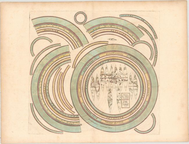
Auction 158, Lot 49
Subject: Cartographic Miscellany, Armillary Sphere
Cassini, Giovanni Maria
[Lot of 2] Circolo per Formare la Sfera Armilare [and] Circoli per Formare la Sfera Armillare, 1795
Size: See Description
Estimate: $1,400 - $1,700
Rare Matching Set to Construct Armillary Sphere
Sold for: $1,600
Closed on 6/22/2016
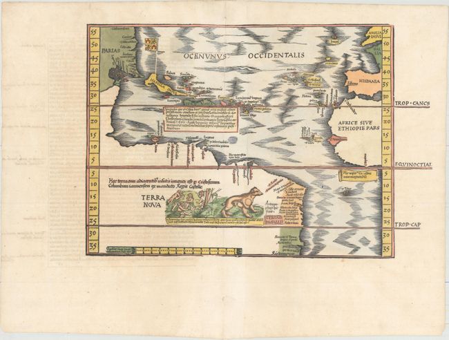
Auction 158, Lot 52
Subject: Western Hemisphere - America, Atlantic Ocean
Waldseemuller/Fries
[Title on Verso] Tabula Terrae Novae, 1541
Size: 16.6 x 11.3 inches (42.2 x 28.7 cm)
Estimate: $9,000 - $10,500
The Waldseemuller/Fries "Admiral's Map"
Sold for: $5,000
Closed on 6/22/2016
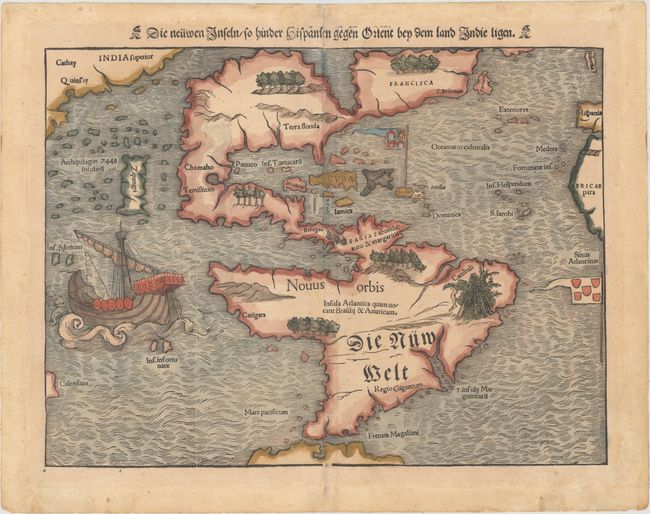
Auction 158, Lot 53
Subject: Western Hemisphere - America
Munster, Sebastian
Die Neuwen Inseln /so Hinder Hispanien Gegen Orient bey dem Land Indie Ligen, 1550
Size: 13.4 x 10.1 inches (34 x 25.7 cm)
Estimate: $5,500 - $7,000
One of the Most Important 16th Century Maps of the New World
Sold for: $4,000
Closed on 6/22/2016
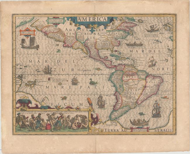
Auction 158, Lot 54
Subject: Western Hemisphere - America
Hondius, Jodocus
America, 1619
Size: 19.8 x 14.8 inches (50.3 x 37.6 cm)
Estimate: $4,000 - $4,750
Hondius' Important Map of the Americas
Sold for: $3,000
Closed on 6/22/2016
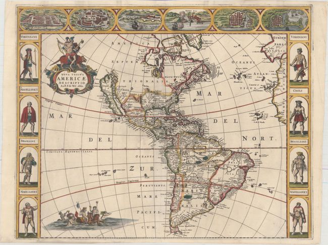
Auction 158, Lot 56
Subject: Western Hemisphere - America
Wit, Frederick de
Nova Totius Americae Descriptio, 1660
Size: 21.9 x 17.3 inches (55.6 x 43.9 cm)
Estimate: $4,500 - $5,500
De Wit's Uncommon Carte-a-Figures Map of the Americas
Sold for: $3,250
Closed on 6/22/2016
Auction 158, Lot 57
Subject: Western Hemisphere - America
Bertius/Tavernier
Carte de l'Amerique Corrigee et Augmentee; Dessus Toutes les Aultres cy Devant Faictes par P. Bertius, 1661
Size: 14.4 x 10.8 inches (36.6 x 27.4 cm)
Estimate: $1,500 - $1,800
Rare Derivative of Hondius' Influential Map
Unsold
Closed on 6/22/2016
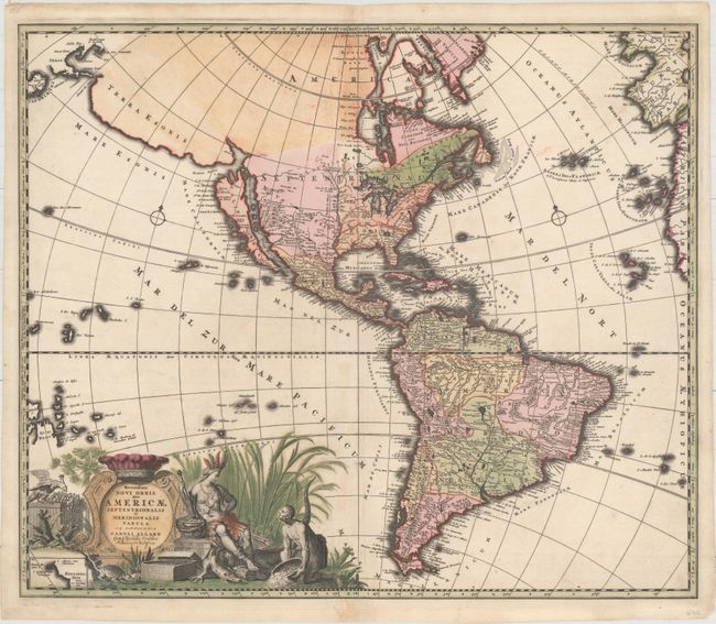
Auction 158, Lot 59
Subject: Western Hemisphere - America
Allard, Carel
Recentissima Novi Orbis sive Americae Septentrionalis et Meridionalis Tabula, 1700
Size: 23 x 19.5 inches (58.4 x 49.5 cm)
Estimate: $2,000 - $2,300
Allard's Elaborate Map of the Western Hemisphere
Sold for: $1,500
Closed on 6/22/2016
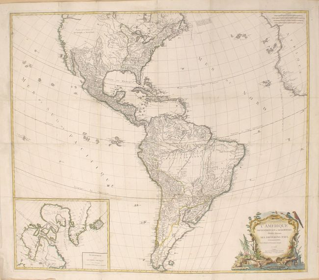
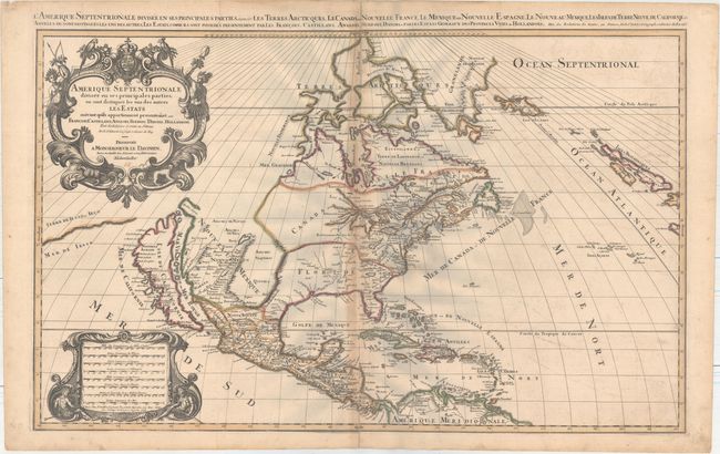
Auction 158, Lot 61
Subject: Western Hemisphere - America
Robert de Vaugondy/Delamarche
L'Amerique Septentrionale et Meridionale Divisee Suivant ses Differens Pays, 1790
Size: 43.8 x 38.3 inches (111.3 x 97.3 cm)
Estimate: $2,000 - $2,500
Impressive Four-Sheet Map of the Americas
Unsold
Closed on 6/22/2016
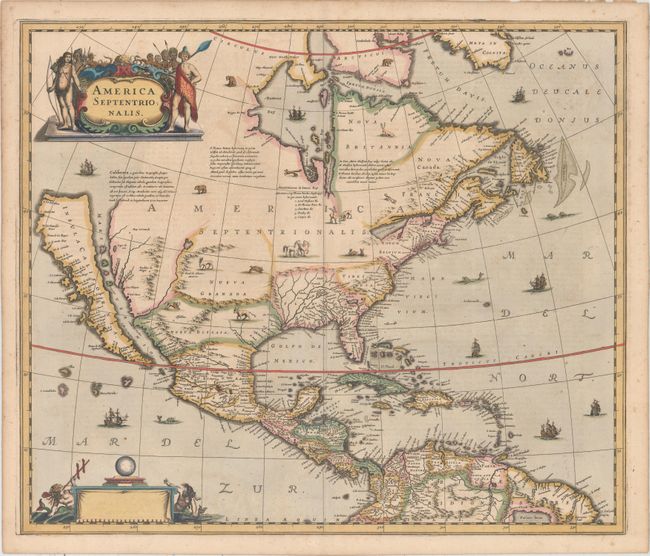
Auction 158, Lot 63
Subject: Colonial North America
Hondius, Henricus
America Septentrionalis, 1639
Size: 21.3 x 18 inches (54.1 x 45.7 cm)
Estimate: $3,000 - $3,750
Rare First State of One of the Most Important Maps Perpetuating the Myth of the Island of California
Sold for: $2,400
Closed on 6/22/2016
Auction 158, Lot 64
Subject: Colonial North America
Sanson/Mortier
Amerique Septentrionale Divisee en ses Principales Parties, ou sont Distingues les uns des Autres les Estats..., 1696
Size: 34.2 x 21.1 inches (86.9 x 53.6 cm)
Estimate: $2,200 - $2,500
Showing the Island of California
Unsold
Closed on 6/22/2016
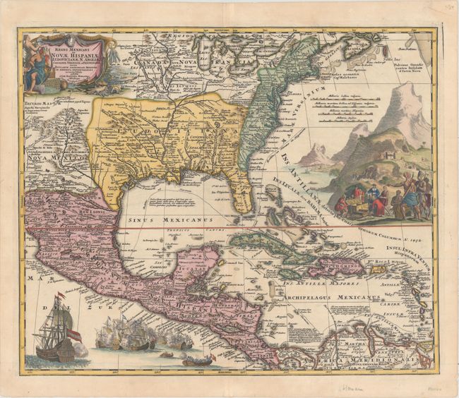
Auction 158, Lot 65
Subject: Colonial North America & Caribbean
Homann, Johann Baptist
Regni Mexicani seu Novae Hispaniae, Ludovicianae, N. Angliae, Carolinae, Virginiae et Pensylvaniae nec non Insularum Archipelagi Mexicani in America Septentrionali Accurata Tabula, 1720
Size: 22.6 x 18.8 inches (57.4 x 47.8 cm)
Estimate: $1,800 - $2,200
Gorgeous Example with Rich Embellishments
Sold for: $1,300
Closed on 6/22/2016
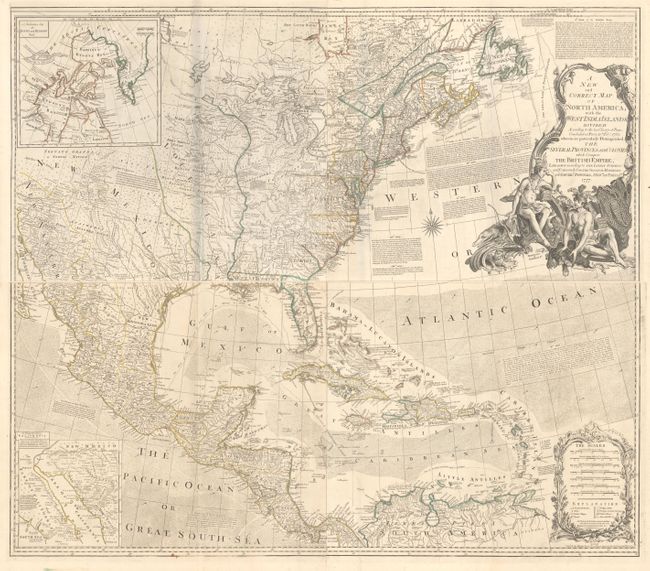
Auction 158, Lot 68
Subject: Colonial North America
Bowen & Gibson
[On 4 Sheets] A New and Correct Map of North America, with the West India Islands. Divided According to the Last Treaty of Peace..., 1777
Size: 45.8 x 20 inches (116.3 x 50.8 cm)
Estimate: $5,000 - $6,500
Bowen & Gibson's Large and Influential Map of North America
Unsold
Closed on 6/22/2016
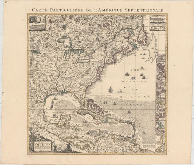
Auction 158, Lot 71
Subject: Colonial Eastern North America & West Indies
Popple/Covens & Mortier
A Map of the British Empire in America with the French, Spanish and the Dutch Settlements Adjacent Thereto, 1741
Size: 18.9 x 19.3 inches (48 x 49 cm)
Estimate: $2,750 - $3,500
Index Sheet of Popple's Map
Unsold
Closed on 6/22/2016
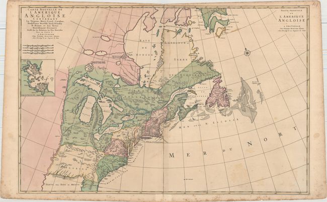
Auction 158, Lot 74
Subject: Colonial Eastern United States & Canada
Mortier, Pierre
Carte Nouvelle de l'Amerique Angloise Contenant la Virginie, Mary-Land, Caroline, Pensylvania Nouvelle Iorck, N: Iarsey N: France, et les Terres Nouvellement Decouerte..., 1700
Size: 35.8 x 23.4 inches (90.9 x 59.4 cm)
Estimate: $2,200 - $2,750
A Map Showing Fascinating Geographic Misconceptions
Unsold
Closed on 6/22/2016
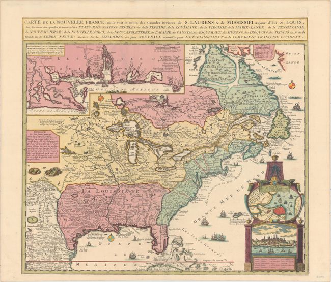
Auction 158, Lot 75
Subject: Colonial Eastern United States & Canada
Fer, Nicolas de
Carte de la Nouvelle France, ou Se Voit le Cours des Grandes Rivieres de S. Laurens & de Mississipi, Aujour d'hui S. Louis…, 1719
Size: 21.7 x 19.6 inches (55.1 x 49.8 cm)
Estimate: $2,750 - $3,500
Striking Map of French Colonial Possessions
Sold for: $2,100
Closed on 6/22/2016
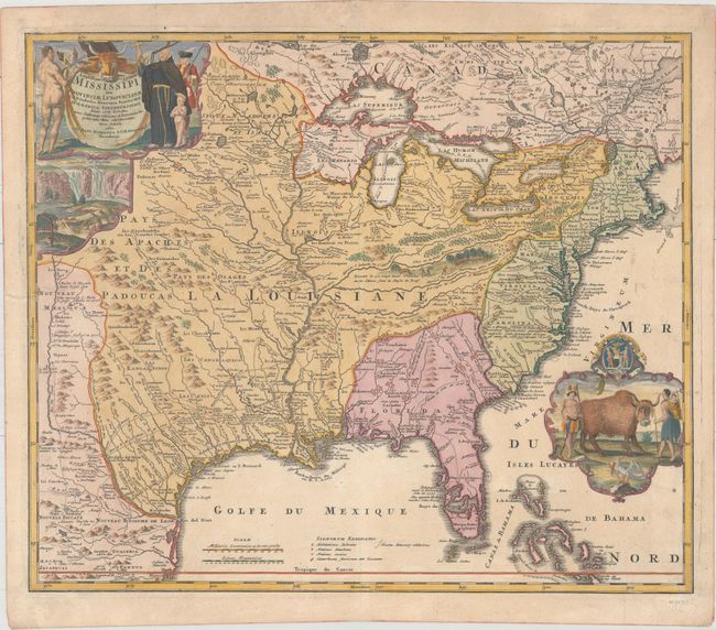
Auction 158, Lot 76
Subject: Colonial Eastern United States & Canada
Homann, Johann Baptist
Amplissimae Regionis Mississipi seu Provinciae Ludovicianae a R.P. Ludovico Hennepin Francisc Miss in America Septentrionali Anno 1687..., 1720
Size: 22.6 x 19.1 inches (57.4 x 48.5 cm)
Estimate: $1,800 - $2,200
Striking Map of Colonial America with Buffalo Vignette
Sold for: $2,300
Closed on 6/22/2016
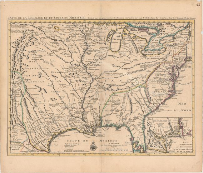
Auction 158, Lot 86
Subject: Colonial Eastern United States, Louisiana Territory
Delisle/Covens & Mortier
Carte de la Louisiane et du Cours du Mississipi Dressee sur un Grand Nombre de Memoires Entr' Autres sur Ceux de Mr. le Maire..., 1730
Size: 23.6 x 17.3 inches (59.9 x 43.9 cm)
Estimate: $2,750 - $3,500
Delisle's Influential Map of the Louisiana Territory
Sold for: $2,000
Closed on 6/22/2016
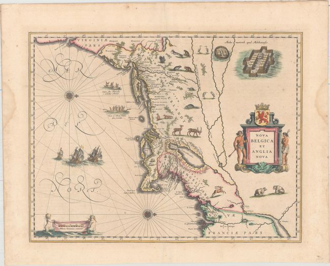
Auction 158, Lot 88
Subject: Colonial New England & Mid-Atlantic United States
Blaeu, Willem
Nova Belgica et Anglia Nova, 1640
Size: 19.9 x 15.3 inches (50.5 x 38.9 cm)
Estimate: $2,750 - $3,500
Important Map of Colonial New England and the Mid-Atlantic in Full Original Color
Unsold
Closed on 6/22/2016
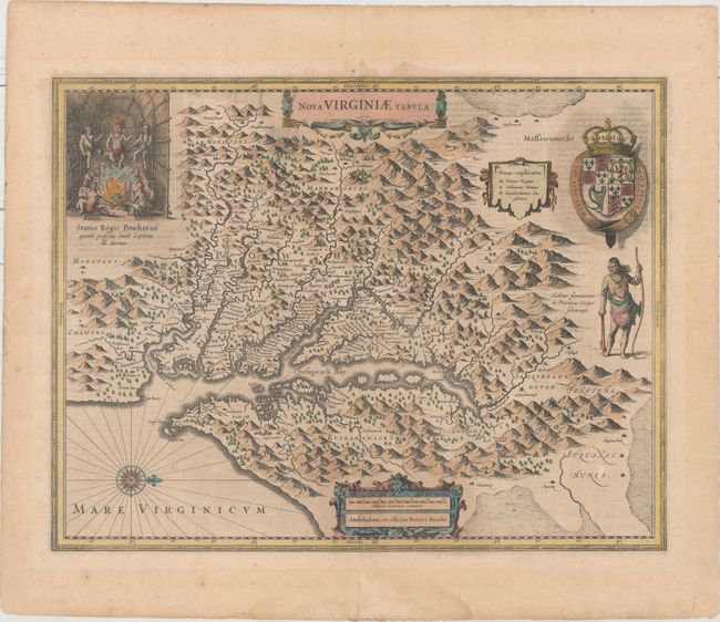
Auction 158, Lot 94
Subject: Colonial Mid-Atlantic United States
Hondius, Henricus
Nova Virginiae Tabula, 1636
Size: 19.5 x 15.1 inches (49.5 x 38.4 cm)
Estimate: $2,000 - $2,300
One of the Most Important 17th Century Maps of the Chesapeake Bay
Unsold
Closed on 6/22/2016
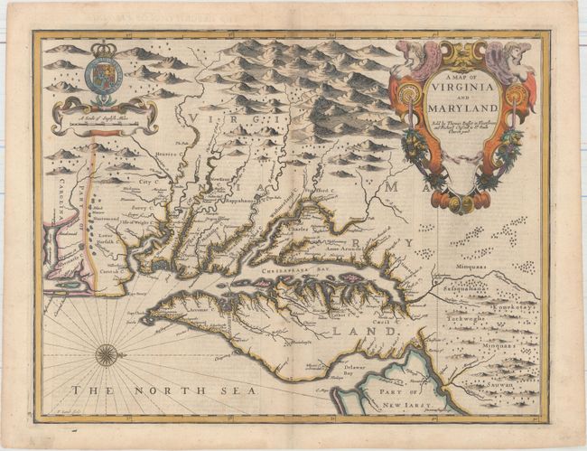
Auction 158, Lot 95
Subject: Colonial Mid-Atlantic United States
Speed/Lamb
A Map of Virginia and Maryland, 1676
Size: 19.4 x 14.9 inches (49.3 x 37.8 cm)
Estimate: $4,750 - $6,000
The First Printed Map to Draw Upon the Legendary Herrman Map of the Chesapeake Bay
Unsold
Closed on 6/22/2016
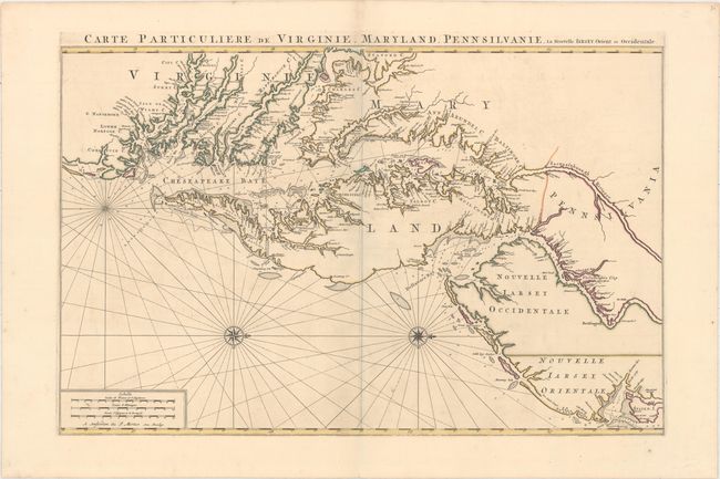
Auction 158, Lot 96
Subject: Colonial Mid-Atlantic United States
Jaillot/Mortier
Carte Particuliere de Virginie, Maryland, Pennsilvanie, la Nouvelle Iarsey. Orient et Occidentale, 1700
Size: 31.8 x 20.6 inches (80.8 x 52.3 cm)
Estimate: $6,000 - $7,500
One of the Most Beautiful Charts of Maryland and the Chesapeake Bay
Unsold
Closed on 6/22/2016
Auction 158, Lot 98
Subject: Colonial Mid-Atlantic United States
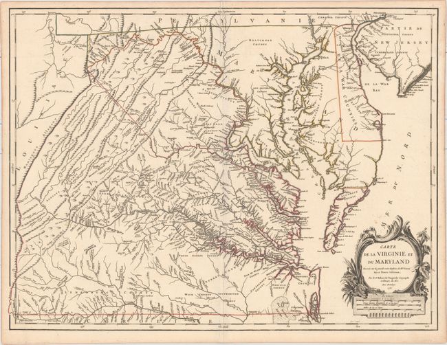
Robert de Vaugondy, Didier
Carte de la Virginie et du Maryland Dressee sur la Grande Carte Angloise de Mrs. Josue Fry et Pierre Jefferson..., 1755
Size: 25.4 x 19.1 inches (64.5 x 48.5 cm)
Estimate: $2,750 - $3,500
First State of Robert de Vaugondy's Essential Map of Virginia and Maryland
Sold for: $2,000
Closed on 6/22/2016
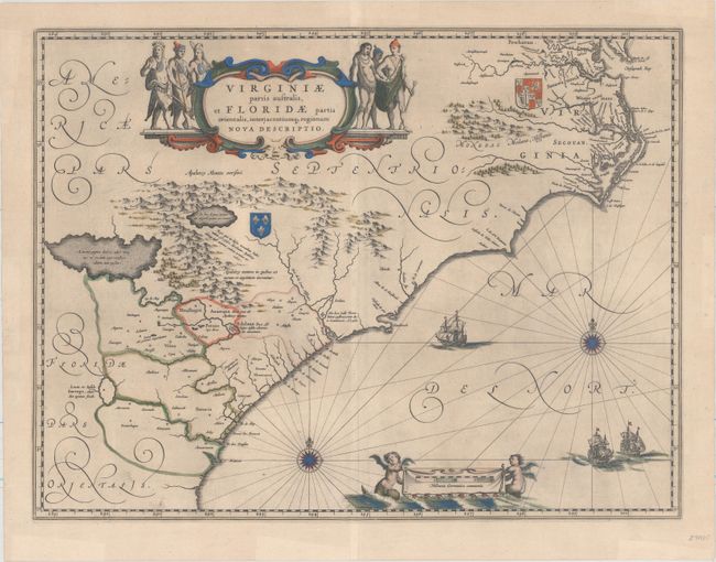
Auction 158, Lot 105
Subject: Colonial Southeastern United States
Blaeu, Willem
Virginiae Partis Australis, et Floridae Partis Orientalis, Interjacentiumq Regionum Nova Descriptio, 1643
Size: 19.6 x 15.2 inches (49.8 x 38.6 cm)
Estimate: $1,600 - $1,900
Blaeu's Decorative Map of the Southeast
Sold for: $1,200
Closed on 6/22/2016
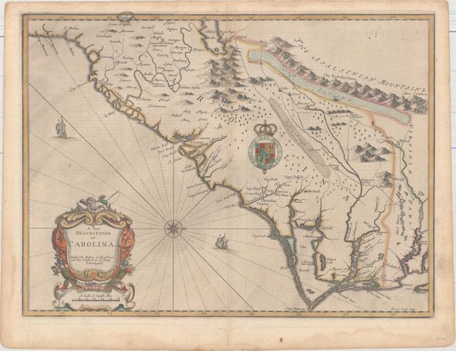
Auction 158, Lot 106
Subject: Colonial Southeastern United States
Speed/Lamb
A New Description of Carolina, 1676
Size: 20 x 14.8 inches (50.8 x 37.6 cm)
Estimate: $4,000 - $5,000
Speed's Map of the Carolinas Based Upon the Lords Proprietor's Map
Unsold
Closed on 6/22/2016
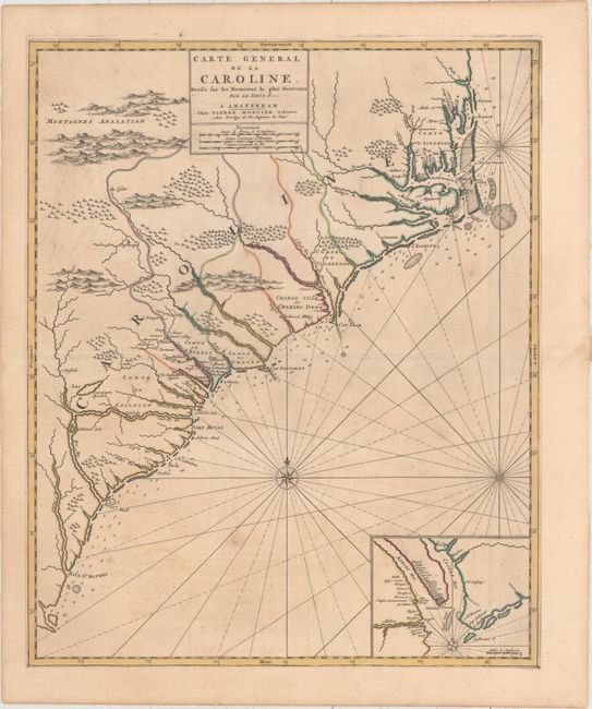
Auction 158, Lot 107
Subject: Colonial Southeastern, North Carolina, South Carolina
Mortier, Pierre
Carte General de la Caroline Dresse sur les Memoires le Plus Nouveaux..., 1700
Size: 18.3 x 22.2 inches (46.5 x 56.4 cm)
Estimate: $3,000 - $3,750
The First Map of the Carolinas Published Outside of England
Sold for: $2,000
Closed on 6/22/2016
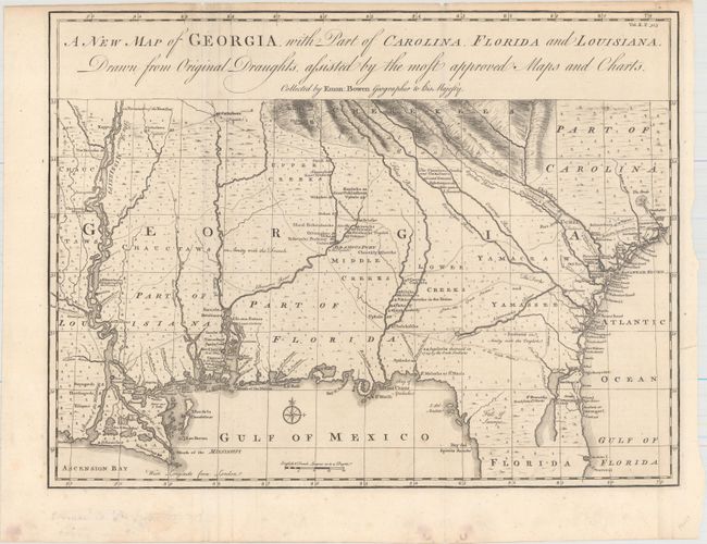
Auction 158, Lot 108
Subject: Colonial Southeastern United States
Bowen, Emanuel
A New Map of Georgia, with Part of Carolina, Florida and Louisiana. Drawn from Original Draughts, Assisted by the Most Approved Maps and Charts, 1748
Size: 18.8 x 14.3 inches (47.8 x 36.3 cm)
Estimate: $3,000 - $3,750
Important Map of the Georgia Colony
Unsold
Closed on 6/22/2016
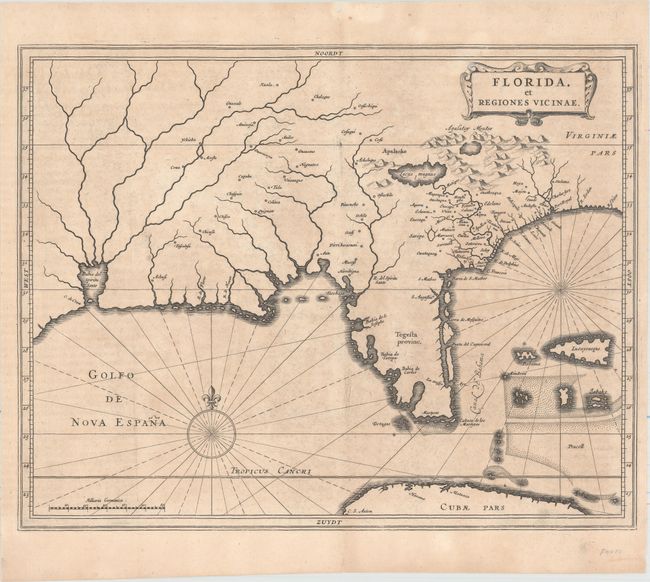
Auction 158, Lot 110
Subject: Colonial Southern United States
Gerritsz/De Laet
Florida, et Regiones Vicinae, 1630
Size: 14 x 11.3 inches (35.6 x 28.7 cm)
Estimate: $3,000 - $3,750
De Laet's Important Map of the South
Unsold
Closed on 6/22/2016
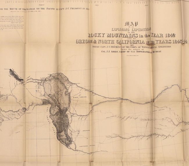
Auction 158, Lot 118
Subject: Western United States
Fremont/Preuss
Map of an Exploring Expedition to the Rocky Mountains in the Year 1842 and to Oregon & North California in the Years 1843-44 [with] Report of The Exploring Expedition to the Rocky Mountains…, 1845
Size: 51 x 30.5 inches (129.5 x 77.5 cm)
Estimate: $1,800 - $2,200
Fremont's Large Map of the American West
Unsold
Closed on 6/22/2016
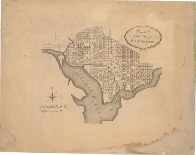
Auction 158, Lot 128
Subject: Washington, D.C.
Thackara, James
Plan of the City of Washington, 1792
Size: 10.4 x 8.5 inches (26.4 x 21.6 cm)
Estimate: $5,000 - $6,500
Very Rare - The First Printed Plan of Washington
Sold for: $3,750
Closed on 6/22/2016
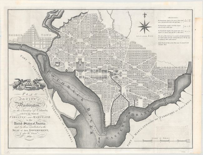
Auction 158, Lot 129
Subject: Washington, D.C.
Russell, John C.
Plan of the City of Washington, in the Territory of Columbia, Ceded by the States of Virginia and Maryland to the United States of America, and by Them Established as the Seat of Their Government, After the Year 1800, 1795
Size: 20.9 x 15.9 inches (53.1 x 40.4 cm)
Estimate: $2,400 - $3,000
Rare, Early Large Format Map of Washington D.C.
Unsold
Closed on 6/22/2016
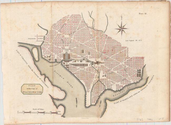
Auction 158, Lot 130
Subject: Washington, D.C.
Plan of the City of Washington, 1805
Size: 10.6 x 8.3 inches (26.9 x 21.1 cm)
Estimate: $2,000 - $2,500
Rare Scottish Plan of Washington
Unsold
Closed on 6/22/2016
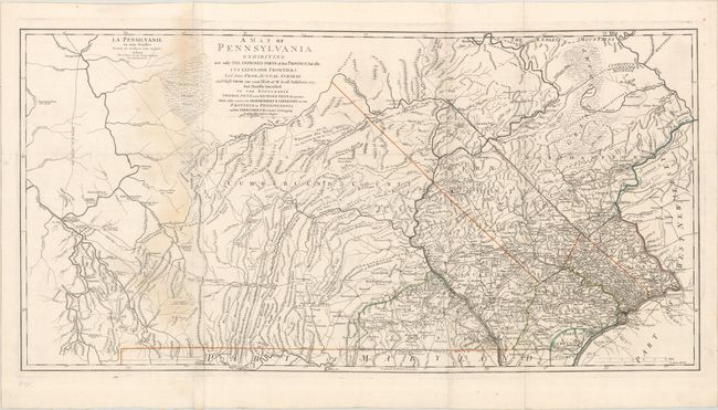
Auction 158, Lot 145
Subject: Pennsylvania, Revolutionary War
Le Rouge, George Louis
La Pensilvanie en Trois Feuilles Traduite des Meilleures Cartes Anglaises / A Map of Pennsylvania Exhibiting Not Only the Improved Parts of That Province, but Also Its Extensive Frontiers..., 1778
Size: 52.1 x 26.3 inches (132.3 x 66.8 cm)
Estimate: $4,500 - $5,500
Scarce French Edition of an Important Revolutionary War Map
Sold for: $2,000
Closed on 6/22/2016
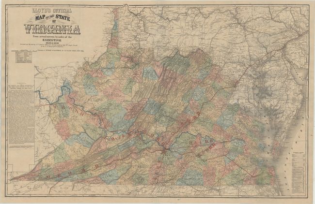
Auction 158, Lot 151
Subject: Virginia
Lloyd, James T.
Lloyd's Official Map of the State of Virginia From Actual Surveys by Order of the Executive 1828 & 1859..., 1862
Size: 47.3 x 30.4 inches (120.1 x 77.2 cm)
Estimate: $2,750 - $3,500
Extremely Rare Promotional Map with Railroad Overprint
Unsold
Closed on 6/22/2016
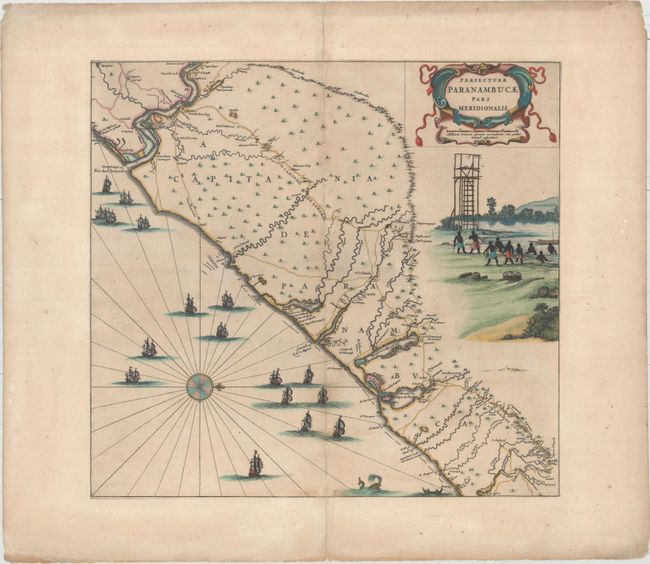
Auction 158, Lot 193
Subject: Eastern Brazil
Blaeu, Johannes
Praefecturae Paranambucae pars Meridionalis, 1647
Size: 17.6 x 16.3 inches (44.7 x 41.4 cm)
Estimate: $1,800 - $2,100
Rare First State of This Important Map of the Brazilian Coast
Unsold
Closed on 6/22/2016
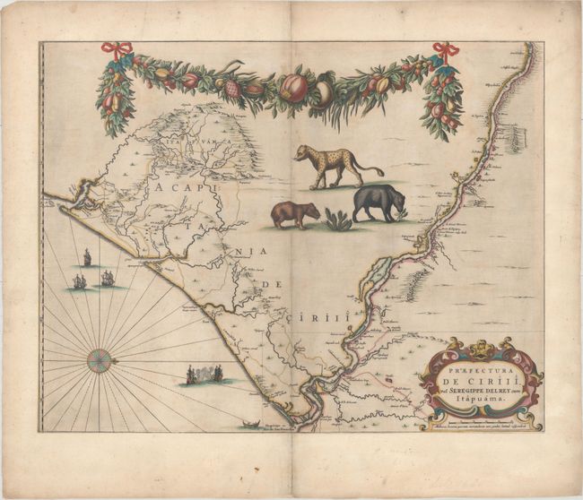
Auction 158, Lot 194
Subject: Eastern Brazil
Blaeu, Johannes
Praefectura de Ciriii, vel Seregirppe Delrey cum Itapuama, 1647
Size: 21.1 x 16.4 inches (53.6 x 41.7 cm)
Estimate: $1,400 - $1,700
From Blaeu's Important Series of Maps of the Brazilian Coast
Sold for: $800
Closed on 6/22/2016
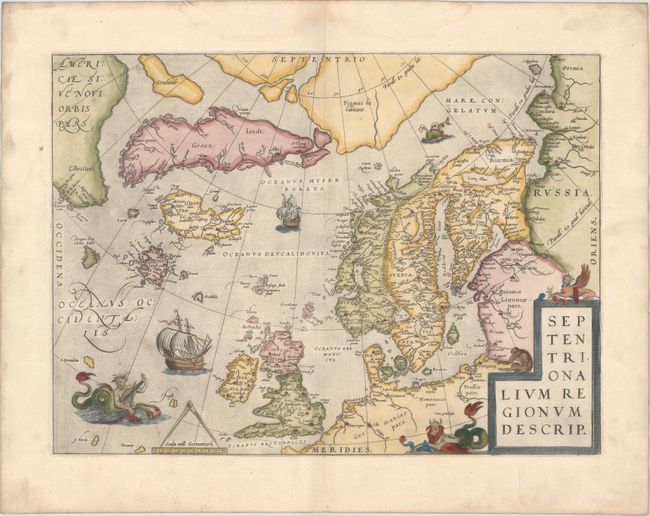
Auction 158, Lot 219
Subject: Arctic & Scandinavia
Ortelius, Abraham
Septentrionalium Regionum Descrip., 1570
Size: 19.3 x 14.3 inches (49 x 36.3 cm)
Estimate: $2,000 - $2,300
Early Example of Ortelius' Map of the Arctic with Mythical Islands
Sold for: $1,600
Closed on 6/22/2016
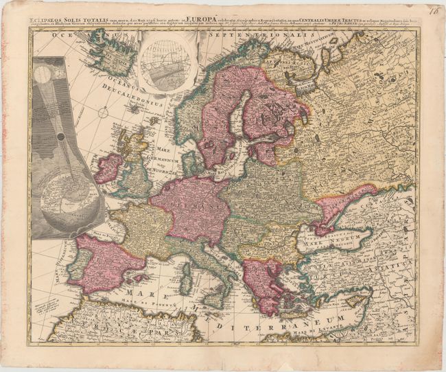
Auction 158, Lot 221
Subject: Europe, Solar Eclipse
Schenk, Pieter
Eclipseos Solis Totalis cum Mora, d. 12 Maji 1706, Horis Antem: in Europa Celebratae, Geographica Repraesentatio..., 1706
Size: 22.7 x 18.6 inches (57.7 x 47.2 cm)
Estimate: $1,400 - $1,700
Rare Map of Solar Eclipse of 1706
Sold for: $800
Closed on 6/22/2016
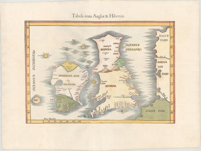
Auction 158, Lot 224
Subject: Britain
Ptolemy/Fries
Tabula Nova Angliae & Hiberniae, 1541
Size: 16 x 11.1 inches (40.6 x 28.2 cm)
Estimate: $1,900 - $2,200
"Modern" Map of the British Isles with the Island of Brazil
Sold for: $1,400
Closed on 6/22/2016
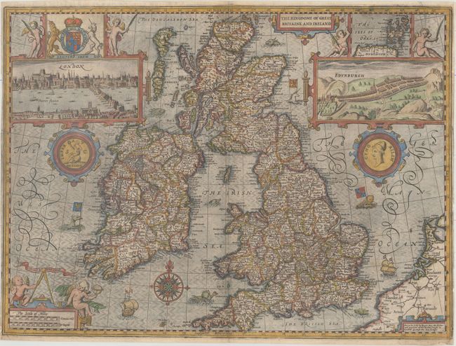
Auction 158, Lot 227
Subject: Britain
Speed, John
The Kingdome of Great Britaine and Ireland, 1665
Size: 20.1 x 15 inches (51.1 x 38.1 cm)
Estimate: $2,750 - $3,500
Speed's Famous Map of the British Isles Engraved by Hondius
Sold for: $2,000
Closed on 6/22/2016
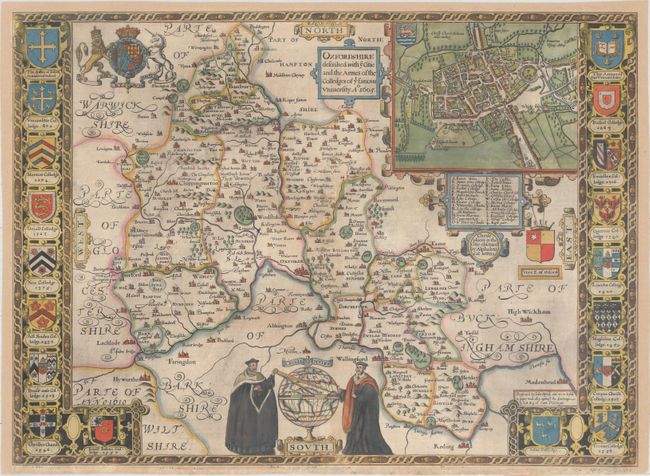
Auction 158, Lot 234
Subject: Southern England
Speed, John
Oxfordshire Described, with ye Citie and the Armes of the Colledges of yt Famous University , 1605
Size: 20.9 x 15.3 inches (53.1 x 38.9 cm)
Estimate: $1,900 - $2,200
Early Example of Speed's Resplendent Map of Oxfordshire
Sold for: $900
Closed on 6/22/2016
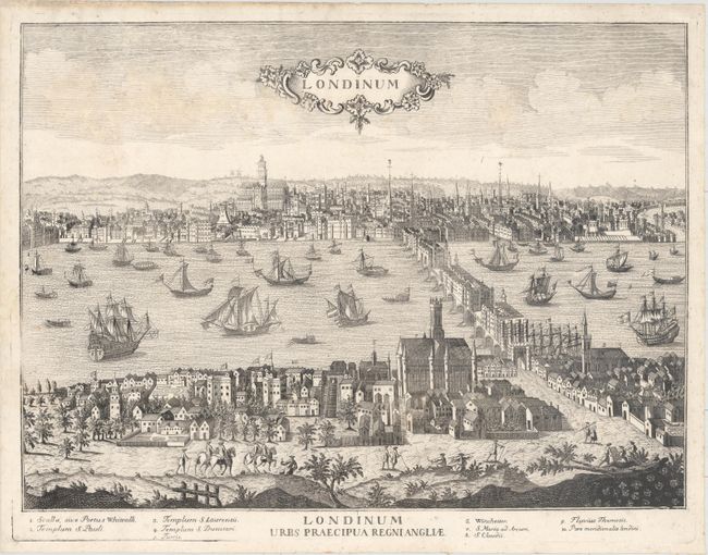
Auction 158, Lot 242
Subject: London, England
Aveline, Antonio
Londinum / Londinum Urbs Praecipua Regni Angliae, 1730
Size: 19.9 x 14.7 inches (50.5 x 37.3 cm)
Estimate: $1,400 - $1,700
Rare View of London
Sold for: $800
Closed on 6/22/2016
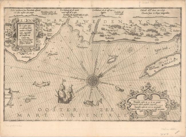
Auction 158, Lot 267
Subject: Southeastern Sweden
Waghenaer, Lucas Jansz
De Custen van een deel van Denemarken en Swederijck, Beginnede va Vuijtste to Calmer Toe..., 1585
Size: 20.3 x 13 inches (51.6 x 33 cm)
Estimate: $1,400 - $1,700
Rare and Early Sea Chart of the Southeastern Coast of Sweden
Sold for: $1,000
Closed on 6/22/2016
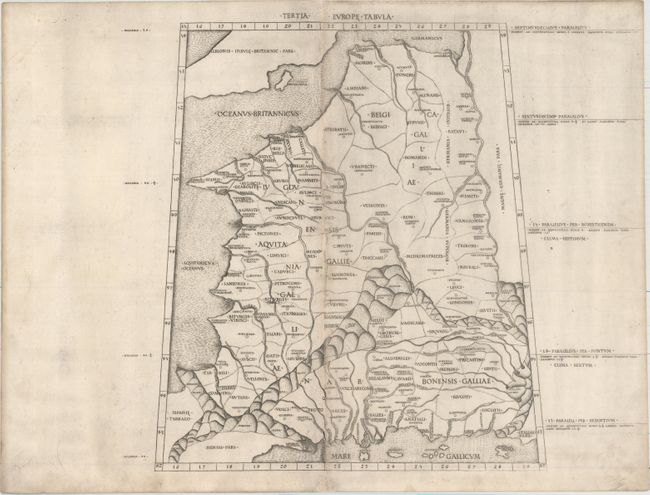
Auction 158, Lot 284
Subject: France
Ptolemy
Tertia Europe Tabula, 1478
Size: 12.6 x 14.4 inches (32 x 36.6 cm)
Estimate: $2,750 - $3,500
Rare and Important Map of France
Sold for: $2,000
Closed on 6/22/2016
68 lots
Page 1 of 2