Subject: Britain
Period: 1541 (published)
Publication: Claudii Ptolemaei Alexandrini Geographicae…
Color: Hand Color
Size:
16 x 11.1 inches
40.6 x 28.2 cm
Claudius Ptolemy was a mathematician, astronomer and geographer who worked in Alexandria, then a part of the Roman Empire, in the 2nd century AD. One of the most learned and influential men of his time, his theories dominated both astronomy and geography for nearly 1500 years. His writings were kept alive by Arabic scholars during the Middle Ages and reemerged in Europe during the Renaissance. The birth of printing led to wide dissemination of his great works on astronomy and geography. There were a number of editions of his Geographia beginning in 1477. These early editions contained maps based on his original writings, known as Ptolemaic maps. As geographic knowledge increased with the explorations of Columbus, Magellan, Cabot and others, maps of the New World were added, and maps of the Old World were revised. Ptolemy's Geographia continued to be revised and published by some of the most important cartographers including Martin Waldseemuller, Sebastian Munster, Giacomo Gastaldi, Jodocus Hondius, and Gerard Mercator (whose last edition was published in 1730).
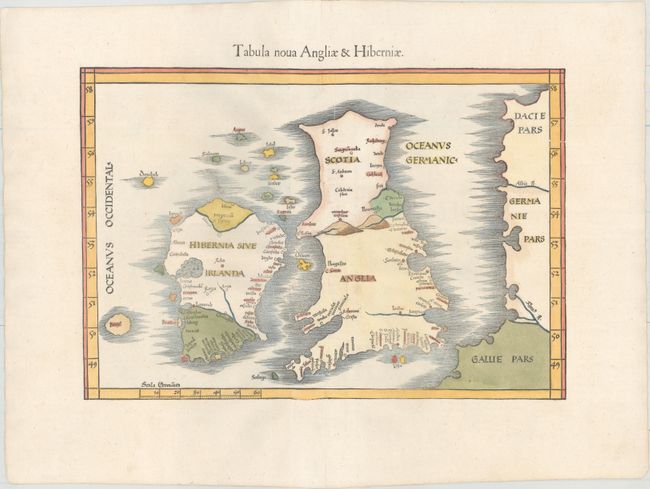
This superb Ptolemaic map is a reduced size version of Waldseemuller's modern map of the British Isles. Waldseemuller based his map on Italian portolan charts, although not necessarily from the most up-to-date charts. The principal cities and rivers are located, as well as a large mountain range between England and Scotland. The majority of the place names appear on the south coast of England, which had been more visited by mariners at the time. Ireland is shown pear-shaped with the "purgatorium of S. Patrick" labeled in the north. To the west of Ireland is the mythical island of Brazil, which continued to appear on maps for over 100 years. This map is from the same woodblock used for the 1522, 1525 and 1535 editions. It was printed by Gaspar Treschsel in Vienne, and is sometimes called the Lugduni-Vienne edition.
References: Mickwitz & Miekkavaara #211-29; Shirley (BI to 1650) #31.
Condition: A
An excellent impression on a clean, bright sheet with two printer's creases adjacent to the centerfold, two small worm holes along the centerfold, and a professionally repaired centerfold separation confined to the top blank margin.