Showing Featured Lots(remove filter)
Filtered by Category:United States(Show All Categories)
Catalog Archive
2174 lots
Page 1 of 44
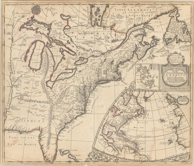
Auction 199, Lot 101
Subject: Colonial Eastern United States & Canada
Senex, John
A New Map of the English Empire in America viz Virginia Maryland Carolina Pennsylvania New York New Iarsey New England Newfoundland New France &c., 1719
Size: 23.3 x 19.8 inches (59.2 x 50.3 cm)
Estimate: $2,400 - $3,000
Senex's Important Map of the American Colonies
Sold for: $1,800
Closed on 9/11/2024
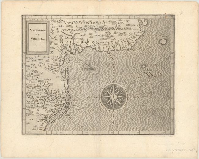
Auction 199, Lot 105
Subject: Colonial Northeastern United States & Canada
Wytfliet, Cornelis
Norumbega et Virginia, 1607
Size: 11.6 x 9.1 inches (29.5 x 23.1 cm)
Estimate: $2,750 - $3,500
Important, Early Map of the East Coast with Mythical City
Sold for: $2,000
Closed on 9/11/2024

Auction 199, Lot 118
Subject: United States
U.S. War Department
Military Map of the United States, 1869
Size: 41.3 x 28.3 inches (104.9 x 71.9 cm)
Estimate: $2,400 - $3,000
Reduced Version of Freyhold's 1868 Map
Sold for: $1,500
Closed on 9/11/2024
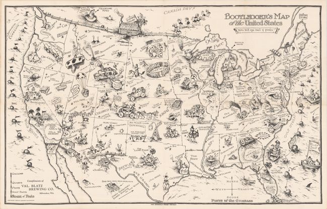
Auction 199, Lot 121
Subject: United States
Bootlegger's Map of the United States, 1926
Size: 34.1 x 21.4 inches (86.6 x 54.4 cm)
Estimate: $1,400 - $1,700
McCandlish's Humorous Prohibition Map
Sold for: $850
Closed on 9/11/2024
Auction 199, Lot 122
Subject: United States, Aviation
Rand McNally & Co.
Illustrated Map of the Route of Transcontinental Air Transport, Inc. , 1929
Size: 30.9 x 14.1 inches (78.5 x 35.8 cm)
Estimate: $1,100 - $1,400
One of the Earliest Commercial Airline Maps
Sold for: $800
Closed on 9/11/2024
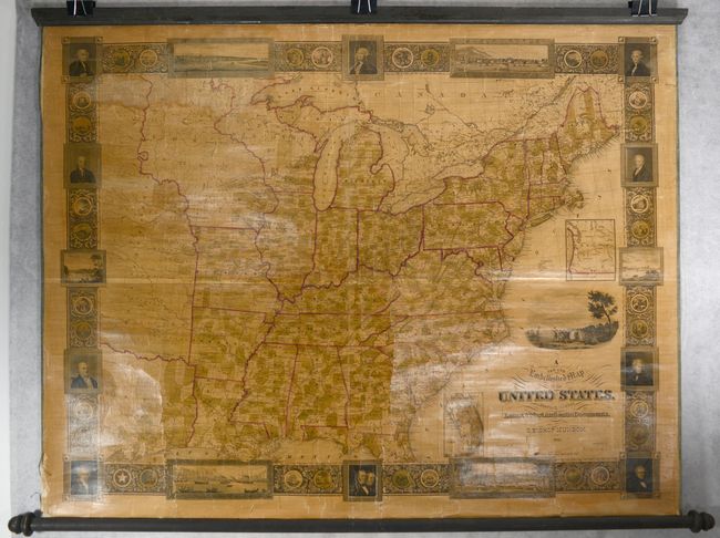
Auction 199, Lot 129
Subject: Eastern United States
A New and Embellished Map of the United States. Compiled from the Latest & Most Authentic Documents, 1845
Size: 47.4 x 36.3 inches (120.4 x 92.2 cm)
Estimate: $2,750 - $3,500
Decorative Wall Map in Contemporary Color
Sold for: $1,800
Closed on 9/11/2024
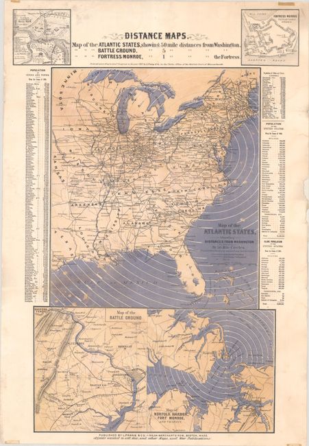
Auction 199, Lot 132
Subject: Eastern United States, Civil War
Prang, Louis
Distance Maps. Map of the Atlantic States Showing 50 Mile Distances from Washington..., 1861
Size: 15 x 22.1 inches (38.1 x 56.1 cm)
Estimate: $1,400 - $1,700
Rare Civil War Distance Map
Sold for: $700
Closed on 9/11/2024
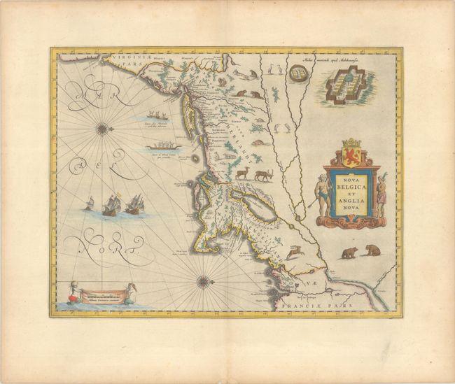
Auction 199, Lot 135
Subject: Colonial New England & Mid-Atlantic United States
Blaeu, (Family)
Nova Belgica et Anglia Nova, 1663
Size: 19.9 x 15.3 inches (50.5 x 38.9 cm)
Estimate: $2,000 - $2,300
Important Map of Colonial New England and the Mid-Atlantic
Sold for: $1,800
Closed on 9/11/2024
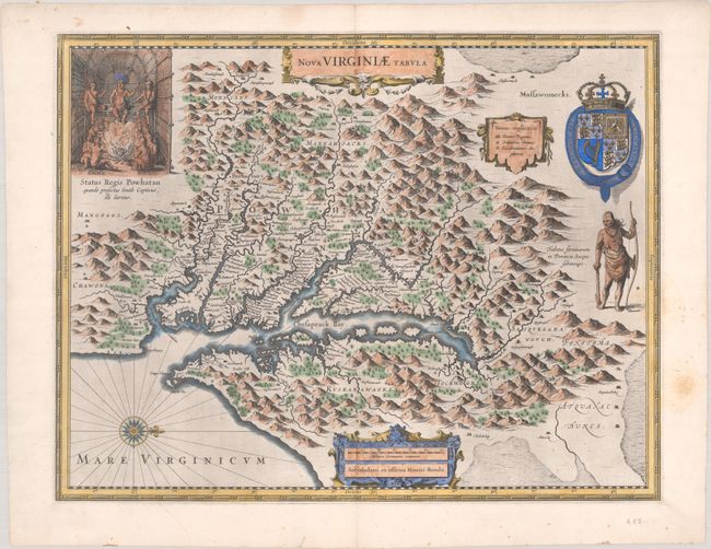
Auction 199, Lot 141
Subject: Colonial Mid-Atlantic United States
Hondius, Henricus
Nova Virginiae Tabula, 1630
Size: 19.4 x 15.1 inches (49.3 x 38.4 cm)
Estimate: $2,000 - $2,300
One of the Most Important 17th Century Maps of the Chesapeake Bay
Sold for: $1,700
Closed on 9/11/2024
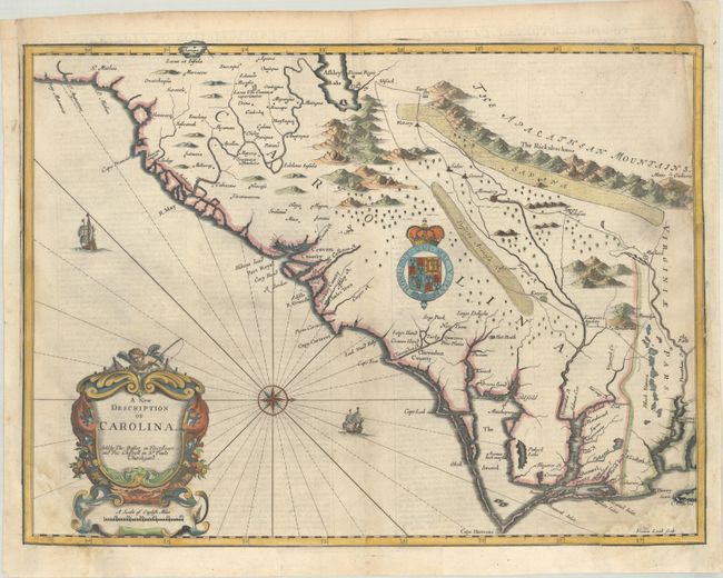
Auction 199, Lot 151
Subject: Colonial Southeastern United States
Speed/Lamb
A New Description of Carolina, 1676
Size: 20 x 14.9 inches (50.8 x 37.8 cm)
Estimate: $2,400 - $3,000
Speed's Map of the Carolinas Based Upon the Lords Proprietor's Map
Unsold
Closed on 9/11/2024

Auction 199, Lot 152
Subject: Colonial Southeastern United States
Keulen, Johannes van
Pas Kaart van de Kust van Carolina Tusschen C de Canaveral en C Henry, 1702
Size: 23 x 20.3 inches (58.4 x 51.6 cm)
Estimate: $2,300 - $2,750
Dutch Chart of the Carolinas
Unsold
Closed on 9/11/2024
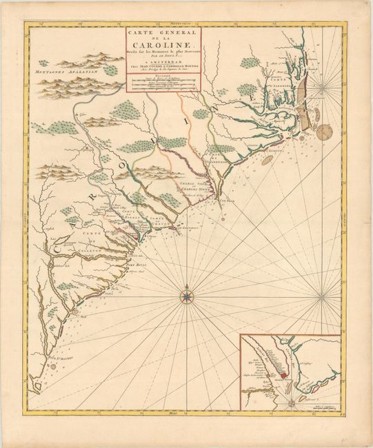
Auction 199, Lot 153
Subject: Colonial Southeastern United States
Covens & Mortier
Carte General de la Caroline. Dresse sur les Memoires le Plus Nouveaux par le Sieua S..., 1730
Size: 18.3 x 22.4 inches (46.5 x 56.9 cm)
Estimate: $2,750 - $3,500
The First Map of the Carolinas Published Outside of England
Sold for: $2,000
Closed on 9/11/2024

Auction 199, Lot 156
Subject: Southeastern United States
Bartram, William
Travels Through North & South Carolina, Georgia, East & West Florida, the Cherokee Country, the Extensive Territories of the Muscogulges, or Creek Confederacy, and the Country of the Chactaws..., 1791
Size: 5.9 x 9.8 inches (15 x 24.9 cm)
Estimate: $9,500 - $11,000
Complete First Edition of Bartram's Work on the American Southeast
Unsold
Closed on 9/11/2024
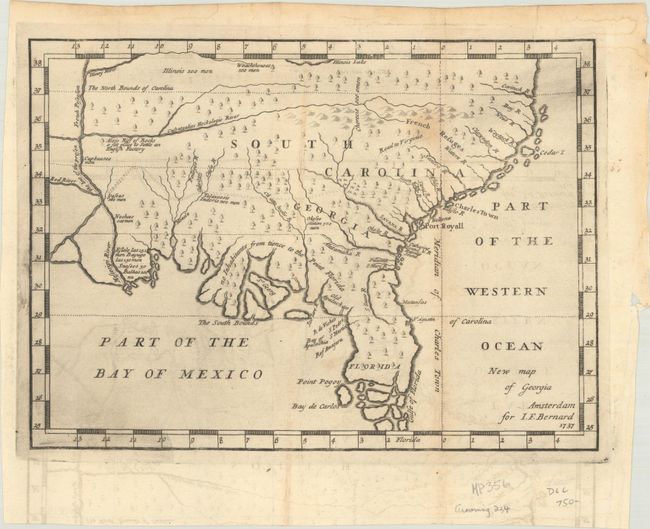
Auction 199, Lot 161
Subject: Colonial Southern United States
Bernard, Jean Frederic
New Map of Georgia, 1737
Size: 10.3 x 7.5 inches (26.2 x 19.1 cm)
Estimate: $1,400 - $1,700
One of the Earliest Published Maps of the English Colony of Georgia
Sold for: $1,000
Closed on 9/11/2024

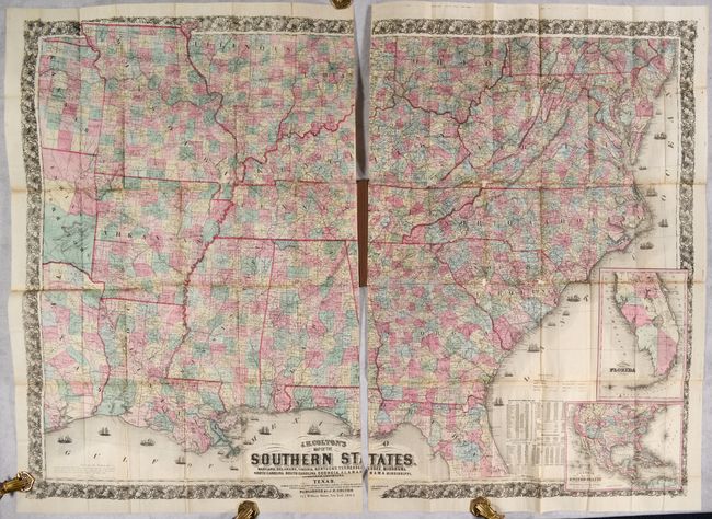
Auction 199, Lot 163
Subject: Southern United States, Civil War
Colton, Joseph Hutchins
J.H. Colton's Map of the Southern States. Maryland, Delaware, Virginia, Kentucky, Tennessee, Missouri, North Carolina, South Carolina, Georgia, Alabama, Mississippi, Arkansas, Louisiana and Texas..., 1864
Size: 52.7 x 38 inches (133.9 x 96.5 cm)
Estimate: $2,400 - $3,000
Large-Scale Map of the South Issued During the Civil War
Unsold
Closed on 9/11/2024
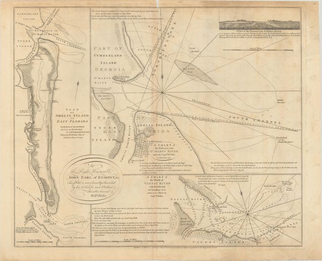
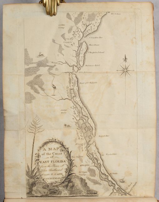
Auction 199, Lot 212
Subject: Amelia Island, Florida
Jefferys, Thomas
A Chart of the Entrance into St. Mary's River Taken by Captn. W. Fuller in November 1769 [on sheet with] Plan of Amelia Island in East Florida [and] A Chart of the Mouth of Nassau River... , 1770
Size: 24.1 x 20 inches (61.2 x 50.8 cm)
Estimate: $2,750 - $3,500
Important Charts Detailing Amelia Island and Surrounding Rivers
Unsold
Closed on 9/11/2024
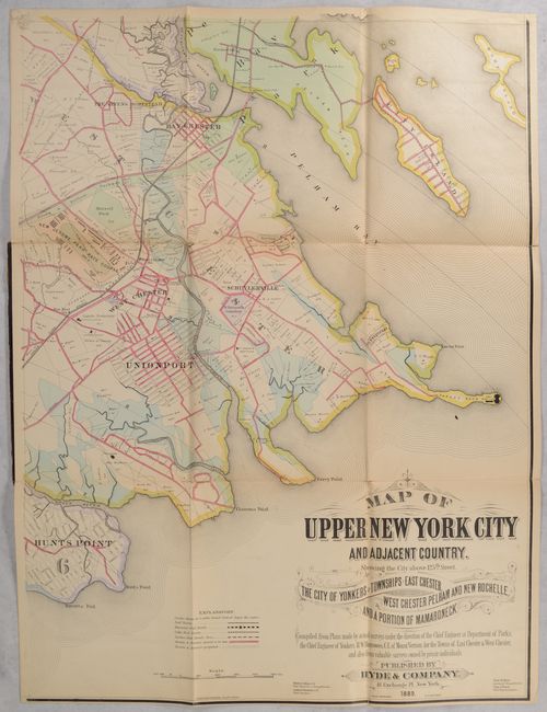
Auction 199, Lot 251
Subject: New York City, New York
[On 4 Sheets] Map of Upper New York City and Adjacent Country. Showing the City Above 125th Street. The City of Yonkers and Townships of East Chester..., 1889
Size: 23.3 x 31 inches (59.2 x 78.7 cm)
Estimate: $1,200 - $1,500
Elaborate 4-Sheet Map of Upper New York City and Westchester County
Unsold
Closed on 9/11/2024
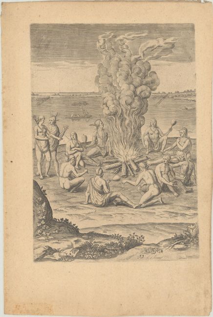
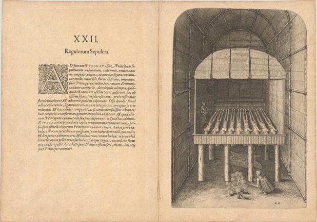
Auction 199, Lot 279
Subject: Virginia, Native Americans
Bry, Theodore de
[Grands Voyages, Part I] Admiranda Narratio Fida Tamen, de Commodis et Incolarum Ritibus Virginiae, Nuper Admodum ab Anglis..., 1608
Size: 9.5 x 13.3 inches (24.1 x 33.8 cm)
Estimate: $1,900 - $2,200
Set of De Bry's Native Virginians & Picts from Part I of Grands Voyages
Sold for: $3,000
Closed on 9/11/2024
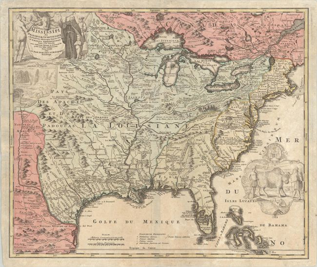
Auction 198, Lot 90
Subject: Colonial Eastern United States & Canada
Homann, Johann Baptist
Amplissimae Regionis Mississipi seu Provinciae Ludovicianae a R.P. Ludovico Hennepin Francisc Miss in America Septentrionali Anno 1687..., 1720
Size: 23 x 19.4 inches (58.4 x 49.3 cm)
Estimate: $2,000 - $2,300
Striking Map of Colonial America with Bison Vignette
Sold for: $1,500
Closed on 6/19/2024
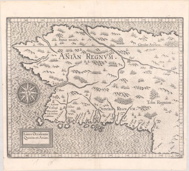
Auction 198, Lot 95
Subject: Alaska & Western Canada
Wytfliet, Cornelis
Limes Occidentis Quivira et Anian, 1607
Size: 11.6 x 9.3 inches (29.5 x 23.6 cm)
Estimate: $1,800 - $2,200
Early and Imaginary Map of Alaska and the Northwest Passage
Sold for: $1,000
Closed on 6/19/2024
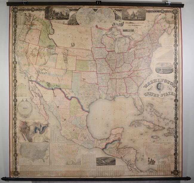
Auction 198, Lot 104
Subject: United States
Maury, M. F.
The Washington Map of the United States, 1861
Size: 68 x 67 inches (172.7 x 170.2 cm)
Estimate: $2,000 - $2,500
Taintor Edition of Maury's Spectacular Wall Map
Sold for: $2,100
Closed on 6/19/2024
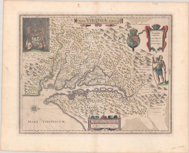
Auction 198, Lot 122
Subject: Colonial Mid-Atlantic United States
Hondius/Blaeu
Nova Virginiae Tabula, 1642
Size: 18.9 x 14.8 inches (48 x 37.6 cm)
Estimate: $1,900 - $2,200
One of the Most Important 17th Century Maps of the Chesapeake Bay in Full Contemporary Color
Sold for: $1,250
Closed on 6/19/2024
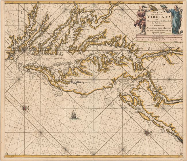
Auction 198, Lot 123
Subject: Colonial Chesapeake & Delaware Bays
Keulen, Johannes van
Pas Kaart van de Zee Kusten van Virginia Tusschen C Henry en t Hooge Land van Renselaars Hoek, 1695
Size: 23.1 x 20.3 inches (58.7 x 51.6 cm)
Estimate: $4,000 - $4,750
One of the Earliest Maps to Show Philadelphia
Sold for: $3,500
Closed on 6/19/2024
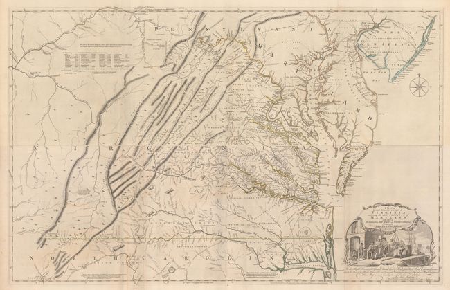
Auction 198, Lot 125
Subject: Colonial Mid-Atlantic United States, Virginia
Fry, Joshua & Jefferson, Peter
[On 4 Sheets] A Map of the Most Inhabited Part of Virginia Containing the Whole Province of Maryland with Part of Pensilvania, New Jersey and North Carolina, 1775
Size: 48.4 x 15.7 inches (122.9 x 39.9 cm)
Estimate: $15,000 - $18,000
1775 Edition of the Landmark Fry-Jefferson Map of Virginia and Maryland
Sold for: $11,000
Closed on 6/19/2024
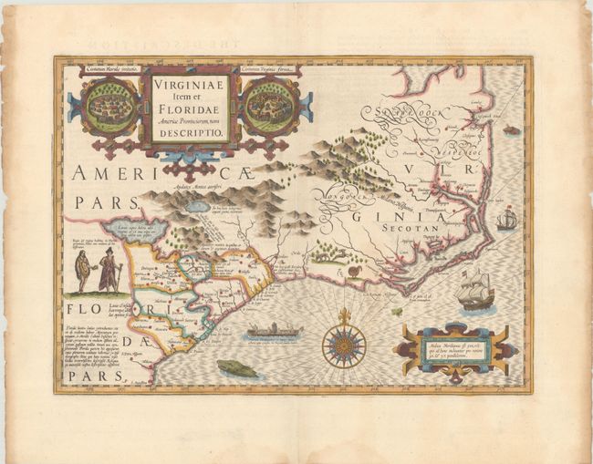
Auction 198, Lot 127
Subject: Colonial Southeastern United States
Mercator/Hondius
Virginiae Item et Floridae Americae Provinciarum, Nova Descriptio, 1636
Size: 19.1 x 13.6 inches (48.5 x 34.5 cm)
Estimate: $2,000 - $2,300
A Seminal Map of the Southeast and Early American Cartography with English Text
Sold for: $1,700
Closed on 6/19/2024
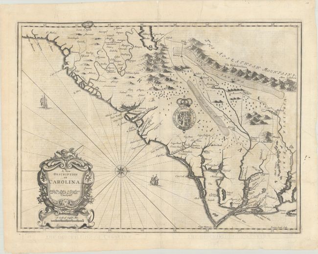
Auction 198, Lot 128
Subject: Colonial Southeastern United States
Speed/Lamb
A New Description of Carolina, 1676
Size: 19.8 x 14.8 inches (50.3 x 37.6 cm)
Estimate: $2,400 - $3,000
Speed's Map of the Carolinas Based Upon the Lords Proprietor's Map
Unsold
Closed on 6/19/2024
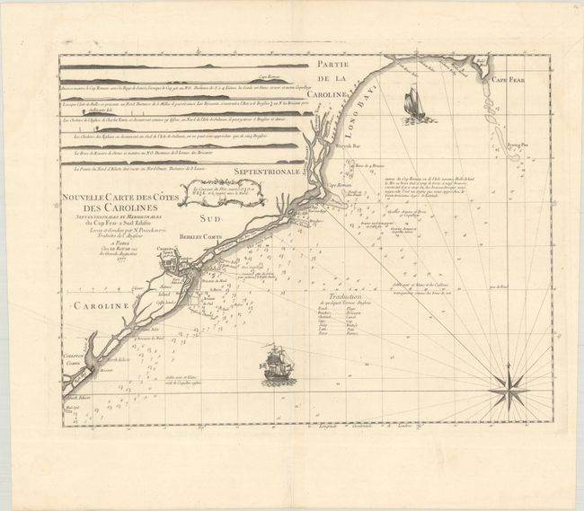
Auction 198, Lot 132
Subject: Colonial Southeastern United States
Le Rouge, George Louis
Nouvelle Carte des Cotes des Carolines Septentrionales et Meridionales du Cap Fear a Sud Edisto..., 1777
Size: 21.3 x 16.1 inches (54.1 x 40.9 cm)
Estimate: $1,400 - $1,700
Rare French Chart of the Carolina Coast
Unsold
Closed on 6/19/2024
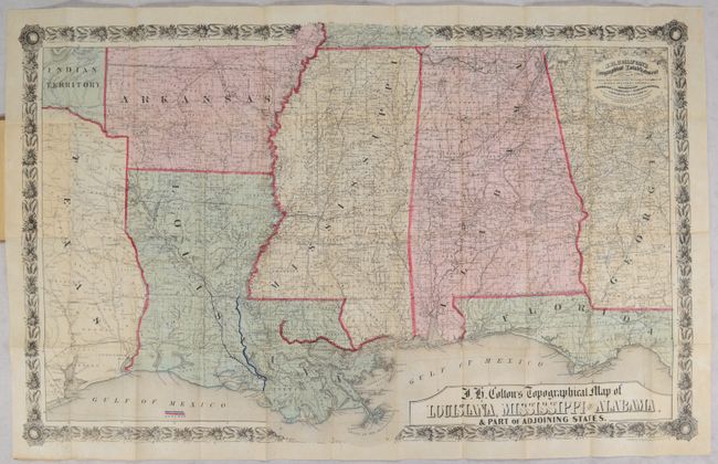
Auction 198, Lot 133
Subject: Southeastern United States, Civil War
Colton, Joseph Hutchins
J.H. Colton's Topographical Map of Louisiana, Mississippi and Alabama. & Part of Adjoining States, 1864
Size: 31.4 x 19.8 inches (79.8 x 50.3 cm)
Estimate: $1,000 - $1,500
Civil War Era Pocket Map with Manuscript Additions
Sold for: $575
Closed on 6/19/2024
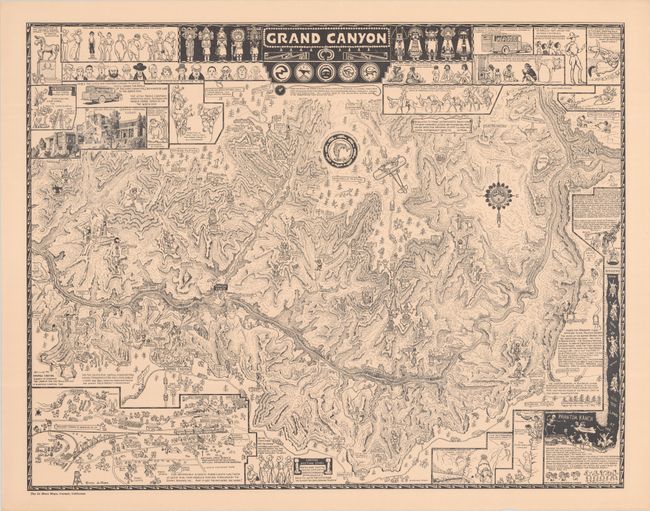
Auction 198, Lot 159
Subject: Grand Canyon, Arizona
Mora, Joseph Jacinto
Grand Canyon, 1931
Size: 25.9 x 20.3 inches (65.8 x 51.6 cm)
Estimate: $1,200 - $1,500
Original Printing of Jo Mora's Classic Pictorial Map of the Grand Canyon
Sold for: $850
Closed on 6/19/2024
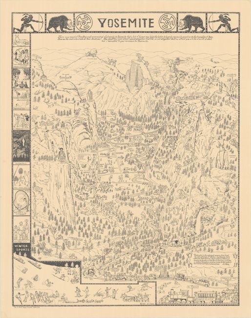
Auction 198, Lot 164
Subject: Yosemite, California
Mora, Joseph Jacinto
Yosemite, 1931
Size: 20.1 x 25.8 inches (51.1 x 65.5 cm)
Estimate: $1,200 - $1,500
Original Printing of Jo Mora's Classic Pictorial Map of Yosemite
Sold for: $1,200
Closed on 6/19/2024
Auction 198, Lot 190
Subject: Florida, Natives
Bry, Theodore de
[Grands Voyages, Part II] Der Ander Theil / der Newlich Erfundenen Landtschafft Americae, von Dreyen Schiffahrten / so die Frantzosen in Floridam..., 1603
Size: 9.1 x 13.4 inches (23.1 x 34 cm)
Estimate: $2,400 - $3,000
Text and Native Floridian Plates from Part II of Grands Voyages
Sold for: $2,750
Closed on 6/19/2024
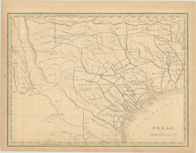
Auction 198, Lot 246
Subject: Republic of Texas
Bradford, Thomas Gamaliel
Texas, 1843
Size: 10.5 x 7.8 inches (26.7 x 19.8 cm)
Estimate: $1,500 - $1,800
Bradford's Map of Texas Showing Early Counties Instead of Land Grants
Sold for: $1,300
Closed on 6/19/2024
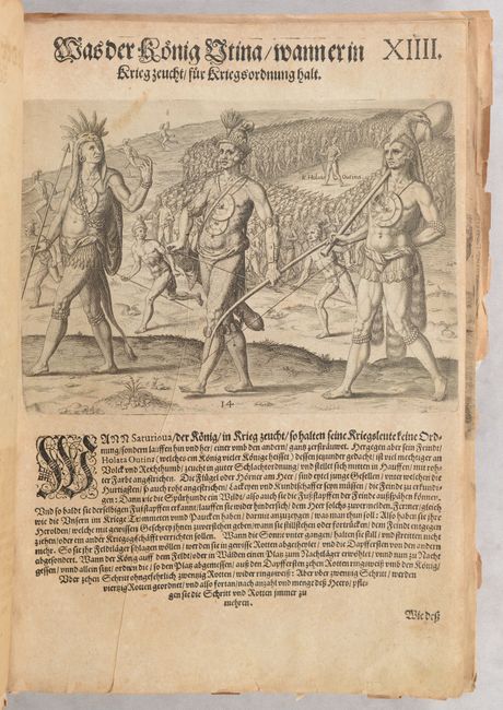
Auction 198, Lot 258
Subject: Virginia, Native Americans
Bry, Theodore de
[Grands Voyages, Part I - 27 Plates of Virginia Natives & Picts], 1608
Size: 9.4 x 12.9 inches (23.9 x 32.8 cm)
Estimate: $2,750 - $3,500
Complete Set of De Bry's Native Virginians & Picts from Part I of Grands Voyages
Sold for: $4,000
Closed on 6/19/2024
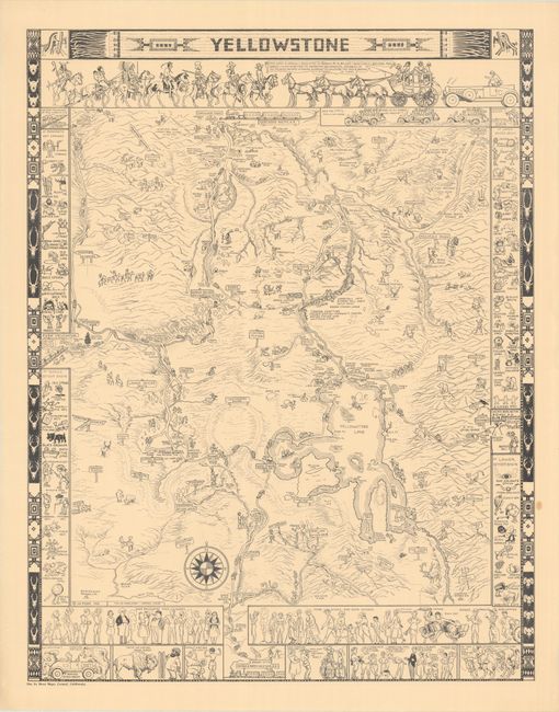
Auction 198, Lot 260
Subject: Yellowstone National Park, Wyoming
Mora, Joseph Jacinto
Yellowstone, 1931
Size: 20.1 x 25.8 inches (51.1 x 65.5 cm)
Estimate: $1,200 - $1,500
Original Printing of Jo Mora's Classic Pictorial Map of Yellowstone
Sold for: $850
Closed on 6/19/2024
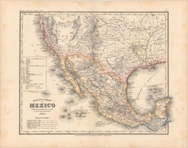
Auction 198, Lot 261
Subject: United States & Mexico
Radefeld, Carl Christian Franz
Neueste Karte von Mexico nach den Besten Quellen..., 1850
Size: 14.8 x 11.6 inches (37.6 x 29.5 cm)
Estimate: $750 - $900
Rare Map Showing The Proposed State of Deseret
Sold for: $500
Closed on 6/19/2024
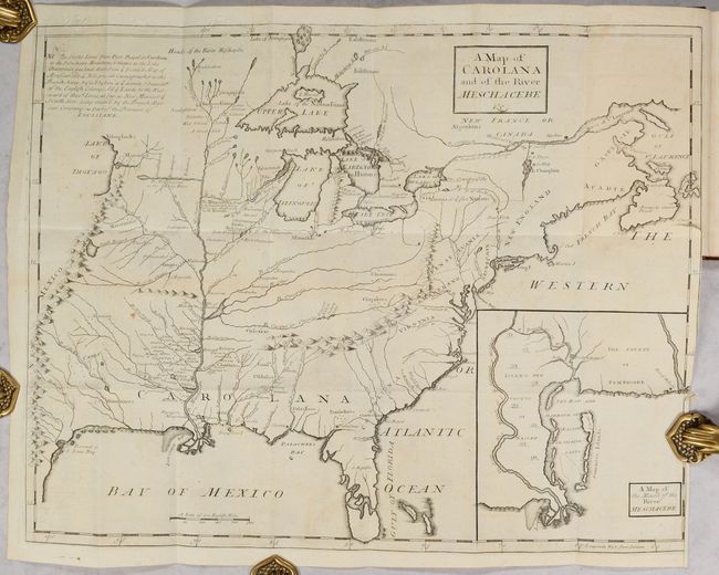
Auction 197, Lot 98
Subject: Colonial Eastern United States & Canada
Coxe, Daniel
[Map in Book] A Map of Carolana and of the River Meschacebe &c. [in] A Description of the English Province of Carolana. By the Spaniards Call'd Florida, and by the French, la Louisiane, 1741
Size: 21.5 x 16.8 inches (54.6 x 42.7 cm)
Estimate: $8,000 - $9,500
First English Depiction of the Mississippi Valley
Sold for: $7,500
Closed on 4/24/2024
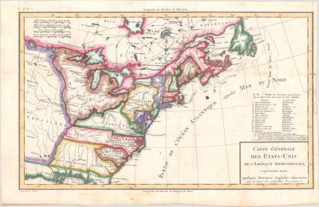
Auction 197, Lot 100
Subject: Eastern United States & Canada, Franklin
Crevecoeur, Michel Guillaume De
Carte Generale des Etats-Unis de l'Amerique Septentrionale, Renfermant Aussi Quelques Provinces Angloises Adjacentes, pour les Lettres d'un Cultivateur Ameriquain, 1787
Size: 16.9 x 10.2 inches (42.9 x 25.9 cm)
Estimate: $600 - $750
One of the Earliest Maps to Name Franklinia
Sold for: $450
Closed on 4/24/2024
Auction 197, Lot 117
Subject: United States
Phelps & Watson
Phelps' New National Map of the United States, 1859
Size: 36.5 x 37.8 inches (92.7 x 96 cm)
Estimate: $2,200 - $2,500
Attractive Wall Map Issued at the Onset of the Civil War
Sold for: $1,400
Closed on 4/24/2024
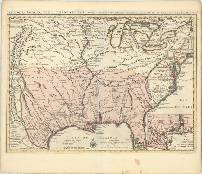
Auction 197, Lot 133
Subject: Colonial Eastern United States, Louisiana Territory
Delisle/Covens & Mortier
Carte de la Louisiane et du Cours du Mississipi Dressee sur un Grand Nombre de Memoires Entr' Autres sur ceux de Mr. le Maire, 1730
Size: 23.5 x 17.2 inches (59.7 x 43.7 cm)
Estimate: $2,200 - $2,500
Delisle's Influential Map of the Louisiana Territory
Sold for: $1,600
Closed on 4/24/2024
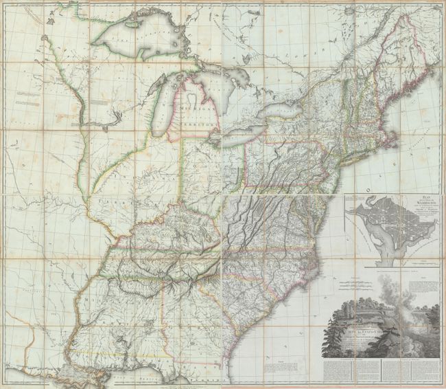
Auction 197, Lot 137
Subject: Eastern United States
Tardieu, Pierre Francois
[On 4 Sheets] United States of Nth America - Carte des Etats-Unis de l'Amerique Septentrionale Copiee et Gravee sur celle d'Arrowsmith..., 1812
Size: 27.9 x 23.9 inches (70.9 x 60.7 cm)
Estimate: $3,500 - $4,500
Rare French Edition of Arrowsmith's Influential Map of the United States
Sold for: $3,500
Closed on 4/24/2024
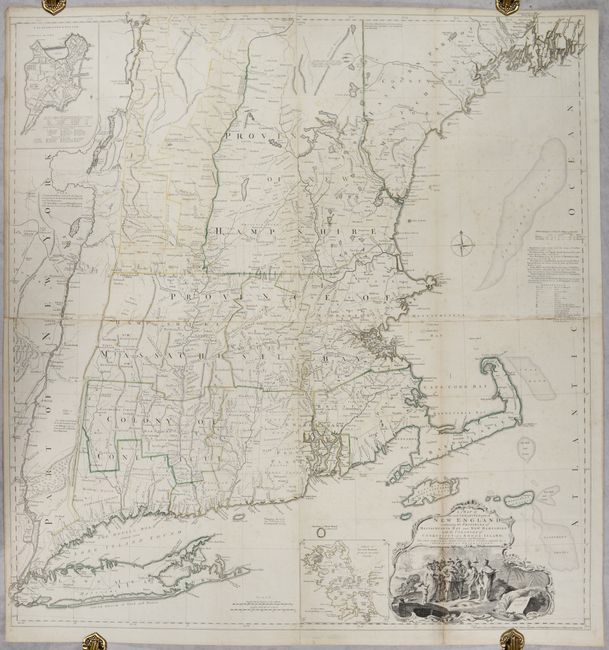
Auction 197, Lot 145
Subject: Colonial New England United States
Jefferys, Thomas
A Map of the Most Inhabited Part of New England, Containing the Provinces of Massachusets Bay and New Hampshire, with the Colonies of Conecticut and Rhode Island..., 1755
Size: 39.1 x 40.8 inches (99.3 x 103.6 cm)
Estimate: $4,750 - $6,000
Rare State of Jefferys' Influential Map of New England in Contemporary Color
Unsold
Closed on 4/24/2024
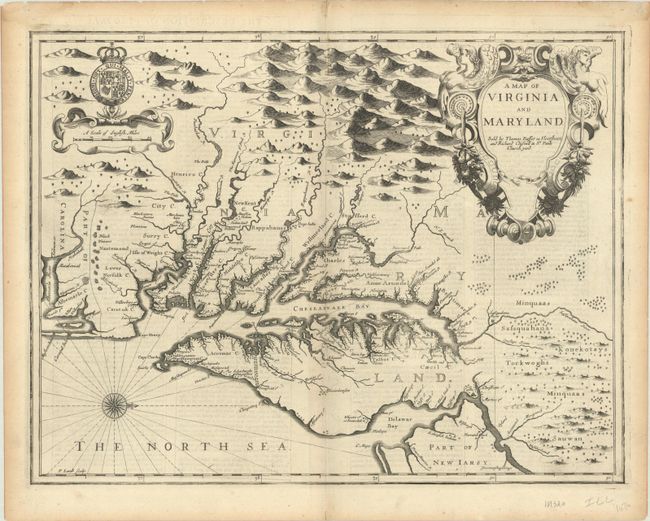
Auction 197, Lot 148
Subject: Colonial Mid-Atlantic United States
Speed/Lamb
A Map of Virginia and Maryland, 1676
Size: 19.6 x 14.9 inches (49.8 x 37.8 cm)
Estimate: $4,000 - $4,750
The First Printed Map to Draw Upon the Legendary Herrman Map of the Chesapeake Bay
Sold for: $2,600
Closed on 4/24/2024
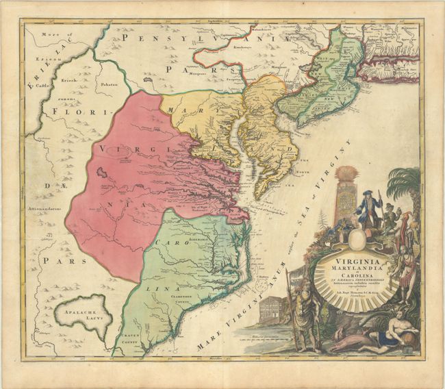
Auction 197, Lot 149
Subject: Colonial Mid-Atlantic United States
Homann, Johann Baptist
Virginia Marylandia et Carolina in America Septentrionali Britannorum Industria Excultae, 1720
Size: 22.8 x 19.3 inches (57.9 x 49 cm)
Estimate: $1,400 - $1,700
Map Created to Promote German Immigration to the New World
Sold for: $1,000
Closed on 4/24/2024
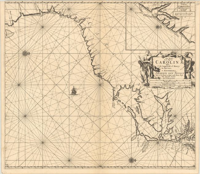
Auction 197, Lot 155
Subject: Colonial Southeastern United States
Keulen, Johannes van
Pas Kaart van de Kust van Carolina Tusschen C de Canaveral en C Henry, 1702
Size: 23 x 20.3 inches (58.4 x 51.6 cm)
Estimate: $2,400 - $3,000
Dutch Chart of the Carolinas
Unsold
Closed on 4/24/2024
Auction 197, Lot 156
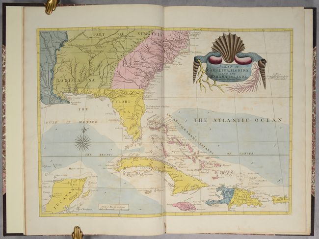
Subject: Colonial Southeastern United States & Bahamas
Catesby, Mark
[Map in Book] A Map of Carolina, Florida and the Bahama Islands with the Adjacent Parts [in] The Natural History of Carolina, Florida, and the Bahama Islands..., 1771
Size: 23.5 x 17.1 inches (59.7 x 43.4 cm)
Estimate: $9,500 - $12,000
Map and Text from Catesby's "Natural History of Carolina"
Sold for: $10,500
Closed on 4/24/2024
Auction 197, Lot 157
Subject: Southeastern United States
Bartram, William
Travels Through North & South Carolina, Georgia, East & West Florida, the Cherokee Country, the Extensive Territories of the Muscogulges, or Creek Confederacy, and the Country of the Chactaws..., 1791
Size: 5.9 x 9.8 inches (15 x 24.9 cm)
Estimate: $10,000 - $12,000
Complete First Edition of Bartram's Work on the American Southeast
Unsold
Closed on 4/24/2024
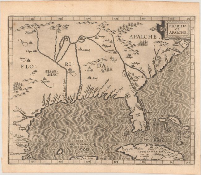
Auction 197, Lot 160
Subject: Southern United States
Wytfliet, Cornelis
Florida et Apalche, 1597
Size: 11.4 x 9.1 inches (29 x 23.1 cm)
Estimate: $3,250 - $4,000
One of the Earliest Obtainable Maps of Florida & the Southeast
Sold for: $3,250
Closed on 4/24/2024
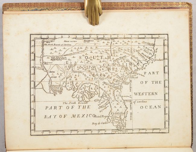
Auction 197, Lot 162
Subject: Colonial Southern United States
[Map in Book] [New Map of Georgia] [in] Reasons for Establishing the Colony of Georgia, with Regard to the Trade of Great Britain..., 1733
Size: 7.3 x 5.3 inches (18.5 x 13.5 cm)
Estimate: $5,500 - $6,500
First Printed Map to Name Georgia
Sold for: $4,000
Closed on 4/24/2024
Auction 197, Lot 166
Subject: Southern United States, Civil War
Colton, Joseph Hutchins
J.H. Colton's Map of the Southern States. Maryland, Delaware, Virginia, Kentucky, Tennessee, Missouri, North Carolina, South Carolina, Georgia, Alabama, Mississippi, Arkansas, Louisiana and Texas..., 1864
Size: 52.7 x 38 inches (133.9 x 96.5 cm)
Estimate: $2,500 - $3,250
Large-Scale Map of the South Issued During the Civil War
Unsold
Closed on 4/24/2024
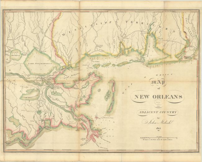
Auction 197, Lot 170
Subject: Louisiana & Mississippi
Melish, John
Map of New Orleans and Adjacent Country, 1815
Size: 21 x 15.4 inches (53.3 x 39.1 cm)
Estimate: $3,500 - $4,500
Scarce War of 1812 Map Highlighting the Gulf Theater of War
Sold for: $1,800
Closed on 4/24/2024
2174 lots
Page 1 of 44