Showing Featured Lots(remove filter)
Filtered by Category:United States(Show All Categories)
Showing results for:Auction 177
Catalog Archive
13 lots
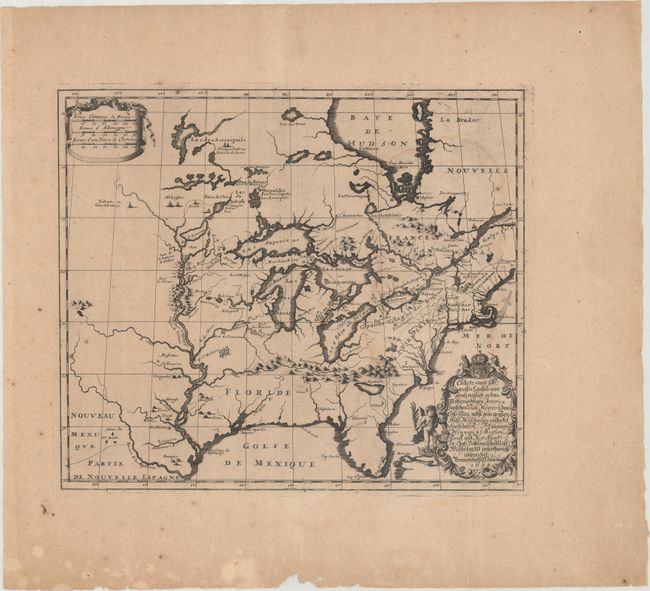
Auction 177, Lot 88
Subject: Colonial Eastern United States & Canada
Hennepin, Louis de (Fr.)
Charte Eines sehr Grossen Landes nur Gantz Neulich in dem Mitternachtigen America..., 1698
Size: 16.7 x 14.4 inches (42.4 x 36.6 cm)
Estimate: $2,200 - $2,500
Rare Separately-Issued German Edition of Hennepin's Map of Eastern North America
Sold for: $2,200
Closed on 4/29/2020
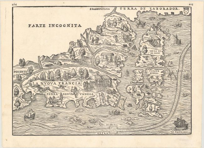
Auction 177, Lot 93
Subject: Northeastern United States & Canada
Gastaldi/Ramusio
La Nuova Francia, 1565
Size: 14.6 x 10.5 inches (37.1 x 26.7 cm)
Estimate: $3,000 - $3,750
The First Printed Map to Focus on New England and New France
Sold for: $3,250
Closed on 4/29/2020

Auction 177, Lot 94
Subject: Colonial Northeastern United States & Canada, Great Lakes
Champlain/Du Val
Le Canada Faict par le Sr de Champlain ou sont la Nouvelle France, la Nouvelle Angleterre, la Nouvelle Holande, la Nouvelle Suede, la Virginie &c..., 1670
Size: 21.4 x 13.8 inches (54.4 x 35.1 cm)
Estimate: $14,000 - $16,000
Very Rare Champlain/Duval Map of New France
Sold for: $10,500
Closed on 4/29/2020
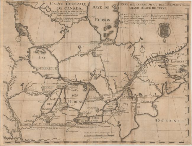
Auction 177, Lot 96
Subject: Colonial Northeastern United States & Canada, Great Lakes
Lahontan, Louis Armand, Baron de
Carte Generale de Canada. Dediee au Roy de Danemark par Son Tres Humble et Tres Obeissant et Tres Fidele Serviteur Lahontan, 1705
Size: 21.5 x 16.4 inches (54.6 x 41.7 cm)
Estimate: $2,200 - $2,500
Lahontan's Map of Canada and the Great Lakes
Sold for: $1,600
Closed on 4/29/2020
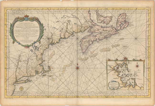
Auction 177, Lot 97
Subject: Colonial Northeastern United States & Canada
Bellin, Jacques Nicolas
Carte Reduite des Costes Orientales de l'Amerique Septentrionale 1re Feuille Contenant l'Isle Royale, l'Accadie, la Baye Francoise, la Nouvelle Angleterre et la Nouvelle Yorc..., 1757
Size: 34.9 x 21.5 inches (88.6 x 54.6 cm)
Estimate: $1,600 - $1,900
Scarce Large-Scale Chart of the Coast of New England
Sold for: $980
Closed on 4/29/2020
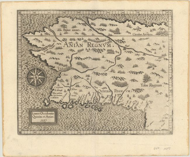
Auction 177, Lot 103
Subject: Alaska & Western Canada
Wytfliet, Cornelis
Limes Occidentis Quivira et Anian, 1597
Size: 11.4 x 9.1 inches (29 x 23.1 cm)
Estimate: $2,000 - $2,300
Early and Imaginary Map of Alaska and the Northwest Passage
Sold for: $1,400
Closed on 4/29/2020
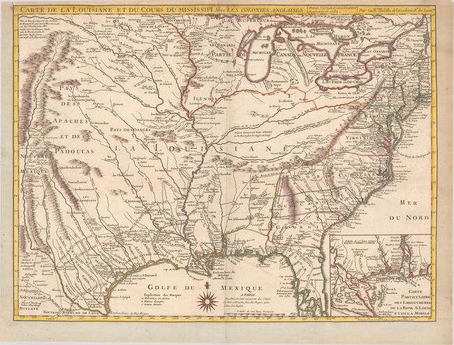
Auction 177, Lot 112
Subject: Colonial Eastern United States, Louisiana Territory
Delisle/Dezauche
Carte de la Louisiane et du Cours du Mississipi avec les Colonies Anglaises, 1782
Size: 25.6 x 19.2 inches (65 x 48.8 cm)
Estimate: $1,400 - $1,700
Delisle's Influential Map of the Louisiana Territory
Sold for: $1,000
Closed on 4/29/2020
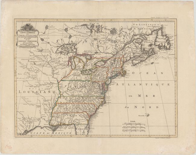
Auction 177, Lot 113
Subject: Eastern United States
Covens & Mortier
Carte Generale des Treize Etats Unis, de l'Amerique Septentrionale / Kaart van de Dertien Verenigde Staaten, in Noord Amerika, 1783
Size: 22.2 x 16.1 inches (56.4 x 40.9 cm)
Estimate: $2,200 - $2,500
Covens and Mortier's Map of the Young United States, with an Early Appearance of the Stars and Stripes
Sold for: $1,600
Closed on 4/29/2020
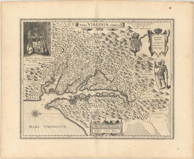
Auction 177, Lot 128
Subject: Colonial Mid-Atlantic United States
Hondius/Blaeu
Nova Virginiae Tabula, 1634
Size: 18.9 x 14.8 inches (48 x 37.6 cm)
Estimate: $1,900 - $2,200
One of the Most Important 17th Century Maps of the Chesapeake Bay
Sold for: $1,400
Closed on 4/29/2020
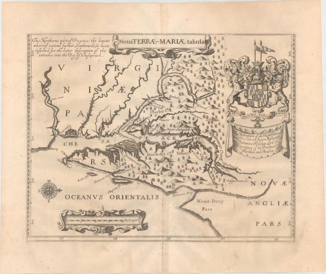
Auction 177, Lot 129
Subject: Colonial Mid-Atlantic United States, Maryland
Ogilby, John
Nova Terrae-Mariae Tabula, 1671
Size: 14.8 x 11.6 inches (37.6 x 29.5 cm)
Estimate: $5,500 - $7,000
Ogilby's Copy of the Extremely Rare "Lord Baltimore's Map," the Earliest Obtainable Printed Map of Maryland
Sold for: $4,000
Closed on 4/29/2020
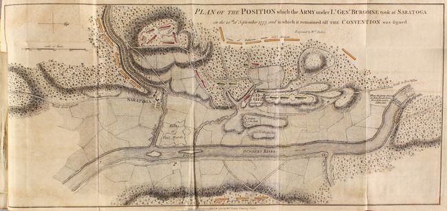
Auction 177, Lot 226
Subject: Colonial New York, Vermont, Revolutionary War
A State of the Expedition from Canada, as Laid Before the House of Commons, 1780
Size: 5.4 x 8.5 inches (13.7 x 21.6 cm)
Estimate: $2,750 - $3,500
General Burgoyne's Account with 6 Battle Maps
Sold for: $2,000
Closed on 4/29/2020
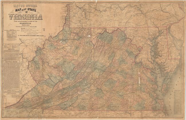
Auction 177, Lot 249
Subject: Virginia & West Virginia, Civil War
Lloyd, James T.
Lloyd's Official Map of the State of Virginia from Original Surveys by Order of the Executive 1828 & 1859..., 1861
Size: 47.3 x 30.3 inches (120.1 x 77 cm)
Estimate: $2,750 - $3,500
First Edition of Lloyd's Civil War Map of Virginia
Unsold
Closed on 4/29/2020
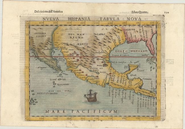
Auction 177, Lot 262
Subject: Southern United States & Mexico
Ruscelli, Girolamo
Nueva Hispania Tabula Nova, 1598
Size: 9.7 x 7.1 inches (24.6 x 18 cm)
Estimate: $1,200 - $1,500
A Foundation Map for the American Southwest
Sold for: $600
Closed on 4/29/2020
13 lots