Showing Featured Lots(remove filter)
Filtered by Category:United States(Show All Categories)
Showing results for:Auction 126
Catalog Archive
24 lots
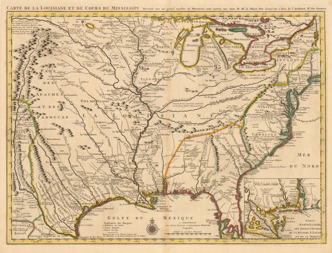
Auction 126, Lot 146
Subject: Colonial United States
Delisle/Covens & Mortier
Carte de la Louisiane et du Cours du Mississipi Dressee sur un Grand Nombre de Memoires entrautres sur ceux de Mr. le Maire, 1733
Size: 23.5 x 17.5 inches (59.7 x 44.5 cm)
Estimate: $2,750 - $3,500
Sold for: $2,500
Closed on 12/3/2008
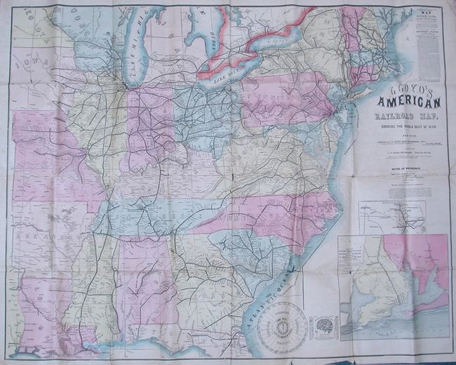
Auction 126, Lot 160
Subject: Eastern United States, Civil War
Lloyd, James T.
Lloyd's American Railroad Map, Showing the Whole Seat of War, 1861
Size: 47.5 x 37 inches (120.7 x 94 cm)
Estimate: $1,000 - $1,400
Sold for: $600
Closed on 12/3/2008
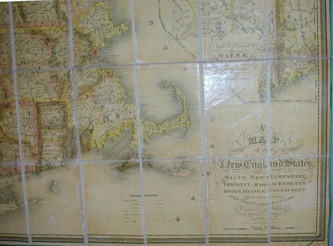
Auction 126, Lot 165
Subject: New England
Hale, Nathan
A Map of the New England States, Maine, New Hampshire, Vermont, Massachusetts, Rhode Island & Connecticut with the Adjacent Parts of New York & Lower Canada, 1826
Size: 40 x 44 inches (101.6 x 111.8 cm)
Estimate: $1,500 - $3,000
Sold for: $900
Closed on 12/3/2008
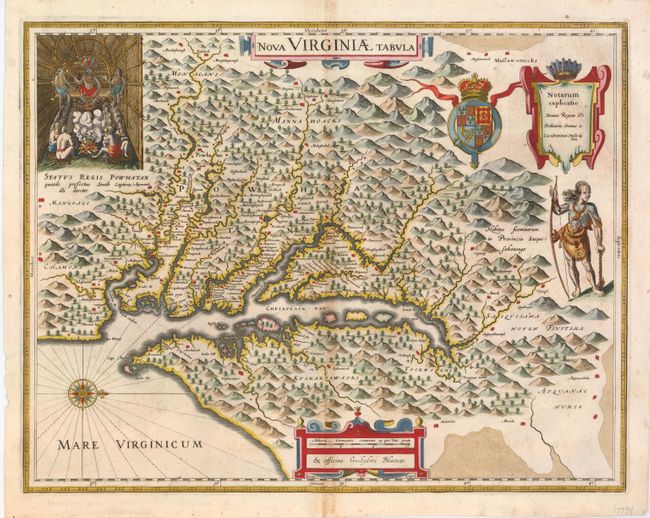
Auction 126, Lot 173
Subject: Colonial Mid-Atlantic
Hondius/Blaeu
Nova Virginiae Tabula, 1680
Size: 18.3 x 14.5 inches (46.5 x 36.8 cm)
Estimate: $2,000 - $2,500
Sold for: $1,600
Closed on 12/3/2008
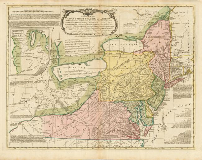
Auction 126, Lot 175
Subject: Colonial Mid-Atlantic
Bowles, Carrington
A General Map of the Middle British Colonies in America…, 1771
Size: 25.3 x 19.3 inches (64.3 x 49 cm)
Estimate: $2,300 - $2,750
Sold for: $1,600
Closed on 12/3/2008
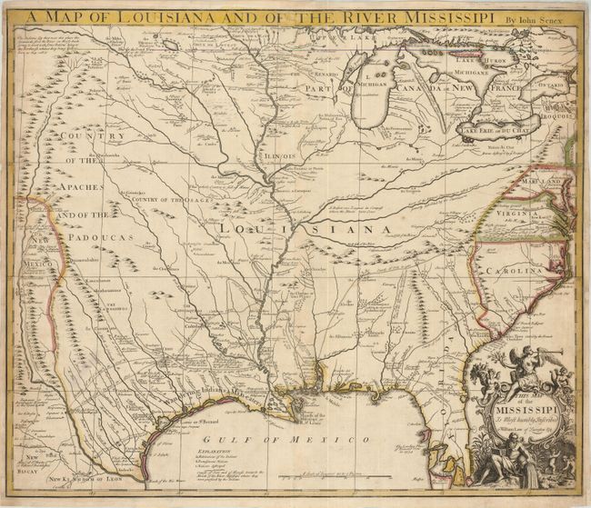
Auction 126, Lot 182
Subject: Colonial Louisiana, Mississippi River
Senex, John
A Map of Louisiana and of the River Mississipi…, 1721
Size: 22.5 x 19 inches (57.2 x 48.3 cm)
Estimate: $2,200 - $3,000
Sold for: $2,300
Closed on 12/3/2008
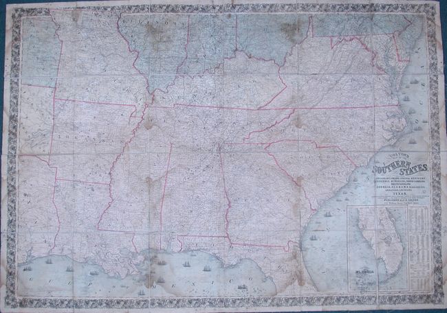
Auction 126, Lot 188
Subject: Southern United States
Colton, Joseph Hutchins
Colton's Map of the Southern States. Including Maryland, Delaware, Virginia, Kentucky, Tennessee, Missouri, North Carolina, South Carolina, Georgia, Alabama, Mississippi, Arkansas, Louisiana, Texa …, 1861
Size: 54.5 x 38 inches (138.4 x 96.5 cm)
Estimate: $800 - $1,000
Sold for: $500
Closed on 12/3/2008
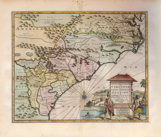
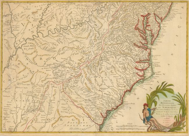
Auction 126, Lot 193
Subject: Colonial Southeast
Aa, Pieter van der
Partie Meridionale de la Virginie, et la Partie Orientale de la Floride dans l'Amerique Septentrionale, 1729
Size: 14 x 11.3 inches (35.6 x 28.7 cm)
Estimate: $1,600 - $2,000
Sold for: $1,100
Closed on 12/3/2008
Auction 126, Lot 196
Subject: Colonial Southeast
Verrier & Perrier
Partie Meridionale des Possessions Angloise en Amerique, pour Servire d'Intelligence a la Guerre Presente…, 1778
Size: 28.5 x 20 inches (72.4 x 50.8 cm)
Estimate: $2,750 - $3,500
Sold for: $1,800
Closed on 12/3/2008
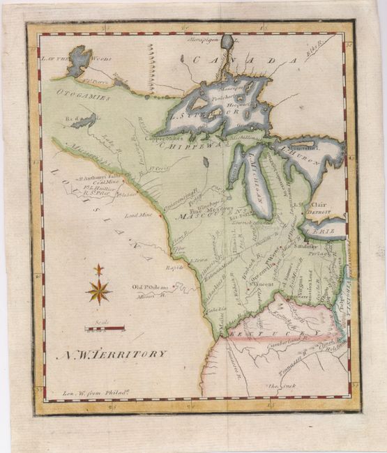
Auction 126, Lot 199
Subject: United States - Midwest
Scott, Joseph
N.W. Territory, 1800
Size: 6 x 7.5 inches (15.2 x 19.1 cm)
Estimate: $500 - $600
Sold for: $650
Closed on 12/3/2008
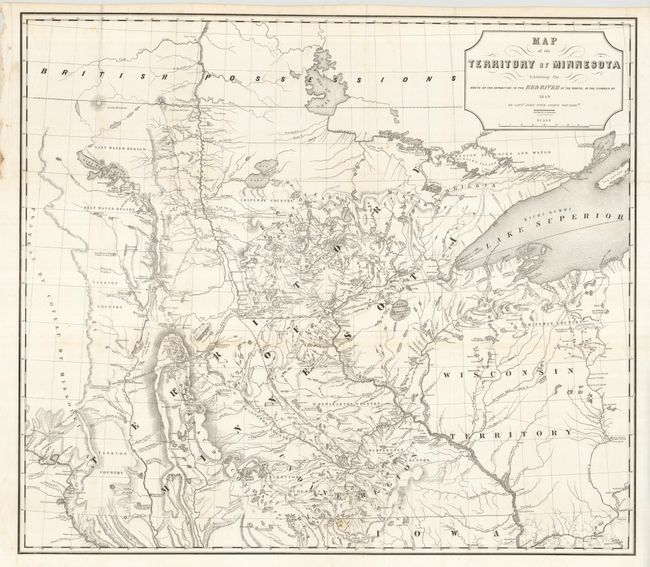
Auction 126, Lot 204
Subject: Minnesota
Pope, John
Map of the Territory of Minnesota Exhibiting the Route of the Expedition to the Red River of the North, in the Summer of 1849, 1849
Size: 28 x 24.7 inches (71.1 x 62.7 cm)
Estimate: $400 - $500
Sold for: $500
Closed on 12/3/2008
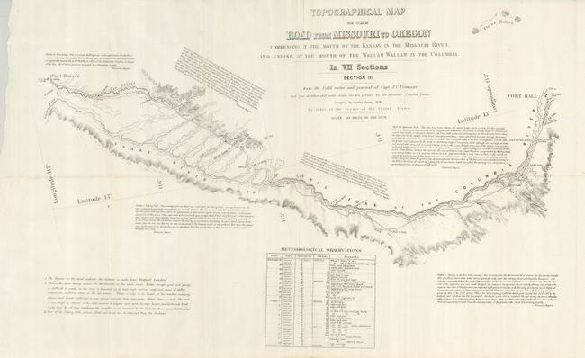
Auction 126, Lot 213
Subject: Western United States
Fremont, John Charles
[Lot of 5] Topographical Map of the Road from Missouri to Oregon… Section III - VII, 1846
Size: 23 x 15 inches (58.4 x 38.1 cm)
Estimate: $1,400 - $2,000
Sold for: $800
Closed on 12/3/2008
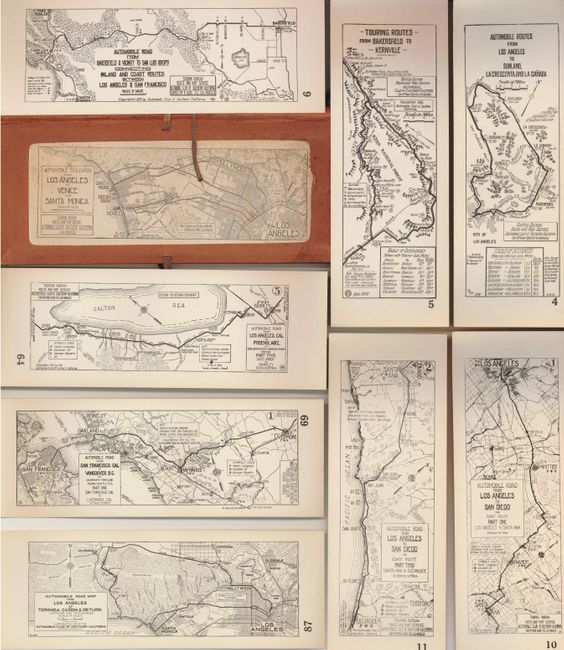
Auction 126, Lot 254
Subject: California
Automobile Club of Southern California
[Collection of 68 - California Road Maps], 1912-15
Size: See Description
Estimate: $300 - $400
Sold for: $350
Closed on 12/3/2008
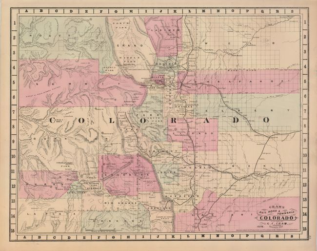
Auction 126, Lot 261
Subject: Colorado
Cram, George F. & Company
Cram's Railroad & Township Map of Colorado, 1879
Size: 20.6 x 16 inches (52.3 x 40.6 cm)
Estimate: $250 - $300
Sold for: $450
Closed on 12/3/2008
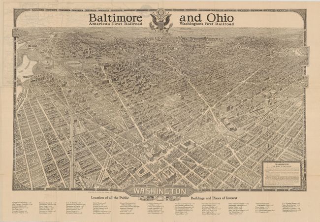
Auction 126, Lot 269
Subject: District of Columbia
Washington - The Beautiful Capital of the Nation, 1923
Size: 28.8 x 20.8 inches (73.2 x 52.8 cm)
Estimate: $400 - $600
Sold for: $425
Closed on 12/3/2008
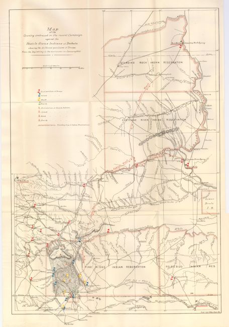
Auction 126, Lot 271
Subject: Dakota Territory
U.S. Army
[Lot of 4 Battle at Wounded Knee Maps], 1890-91
Size: See Description
Estimate: $600 - $800
Sold for: $650
Closed on 12/3/2008
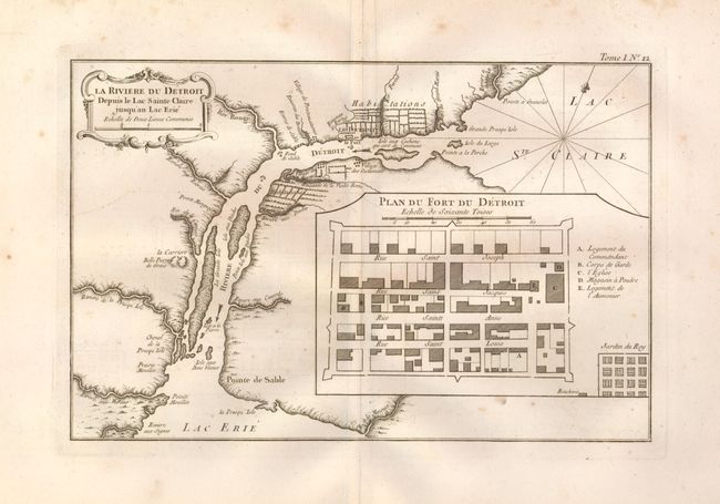
Auction 126, Lot 301
Subject: Michigan, Detroit
Bellin, Jacques Nicolas
La Riviere du Detroit Depuis le Lac Sainte Claire jusqu'an Lac Erie, 1764
Size: 12.5 x 8.2 inches (31.8 x 20.8 cm)
Estimate: $1,000 - $1,200
Sold for: $950
Closed on 12/3/2008
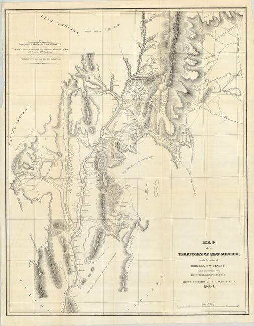
Auction 126, Lot 315
Subject: New Mexico
Abert & Peck
Map of the Territory of New Mexico, made by order of Brig. Gen. S. W. Kearney…, 1846-47
Size: 19.5 x 25 inches (49.5 x 63.5 cm)
Estimate: $800 - $1,200
Sold for: $600
Closed on 12/3/2008
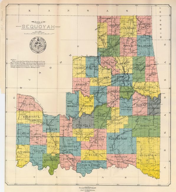
Auction 126, Lot 333
Subject: Oklahoma
U.S. Government
State of Sequoyah, 1905
Size: 14.9 x 16 inches (37.8 x 40.6 cm)
Estimate: $800 - $1,200
Sold for: $850
Closed on 12/3/2008
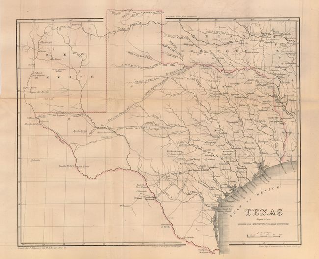
Auction 126, Lot 341
Subject: Texas
Lemercier
Texas d'apres la Carte Publiee par J.H. Colton, 1854
Size: 14 x 11.2 inches (35.6 x 28.4 cm)
Estimate: $400 - $600
Sold for: $210
Closed on 12/3/2008
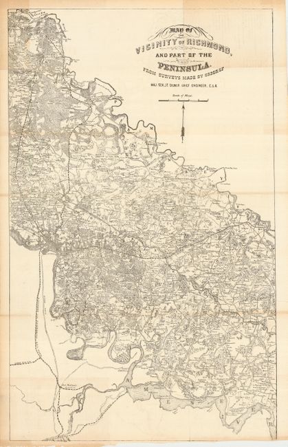
Auction 126, Lot 348
Subject: Virginia, Civil War
Gilmer, Jeremy Francis
Map of the Vicinity of Richmond, and Part of the Peninsula. From Surveys Made by the Order of Maj. Gen. J. F. Gilmer Chief Engineer, C.S.A., 1862-63
Size: 16.5 x 27 inches (41.9 x 68.6 cm)
Estimate: $700 - $800
Sold for: $850
Closed on 12/3/2008
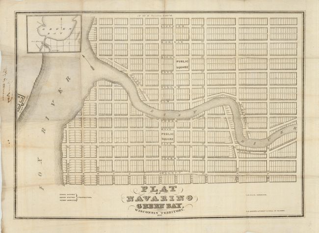
Auction 126, Lot 355
Subject: Wisconsin, Green Bay
Ellis, A.G.
Plat of Navarino Green Bay, Wisconsin Territory. 1836. Daniel Whitney, Joshua Whitney, Henry Hamilton - Proprietors, 1836
Size: 23.3 x 17 inches (59.2 x 43.2 cm)
Estimate: $2,000 - $4,000
Sold for: $1,300
Closed on 12/3/2008
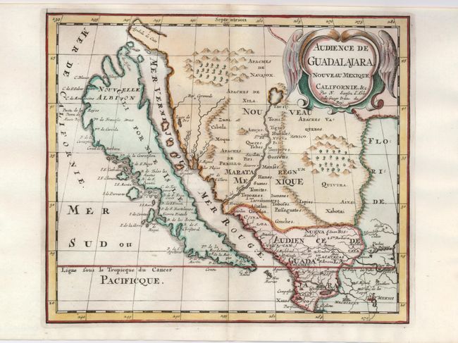
Auction 126, Lot 361
Subject: California & Mexico
Sanson, Nicolas
Audience de Guadalajara, Nouveau Mexique, Californie, &c., 1660
Size: 9.2 x 7.8 inches (23.4 x 19.8 cm)
Estimate: $1,200 - $1,500
Sold for: $1,400
Closed on 12/3/2008
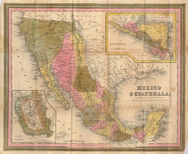
Auction 126, Lot 369
Subject: United States, Texas & Mexico
Mitchell, Samuel Augustus
Mexico & Guatemala, 1846
Size: 14.5 x 12 inches (36.8 x 30.5 cm)
Estimate: $400 - $600
Sold for: $1,100
Closed on 12/3/2008
24 lots