Subject: Eastern United States, Civil War
Period: 1861 (dated)
Publication:
Color: Hand Color
Size:
47.5 x 37 inches
120.7 x 94 cm
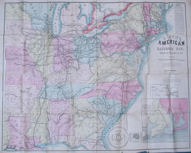
This rare map was issued only two months after the beginning of the American Civil War. This huge map is on the back of "Lloyd's American Railway Weekly," June 15, 1861, which is considered the definitive reference for the railway system east of the Mississippi. Drawn on a scale of 30 miles per inch it presents an amazing amount of detail including railroad stations, towns and villages, watershed, topography and more. The map extends westward to show a small portion of Texas, north to above Augusta, Maine and south to include the Florida panhandle in its entirety. The large fully colored inset "Escambia, Santa Rosa Cos. FL. Showing Pensacola Harbor" (12" x 11") details the vicinity of Pensacola showing Fort Pickens, Fort McRae, Bragg's Batteries and the U.S. Fleet in the harbor. The second inset the "Railroads in Texas" (7.2" x 3.5) focuses on the railway system from Houston and south; locates Austin. A large vignette "Lloyd's American Weekly Time Dial" explains the time in 28 cities across the U.S. The verso contains "Historical and Descriptive Sketch of All Places of Interest in the Southern States" which begins with a long article on the region. The extensive railroad schedule provides times for hundreds of trains, with advertisements filling the balance. Later issues did not provide information for Southern railroads as does this early example. A rare issue.
References: Modelski #43; Stephenson #14.
Condition: B+
The map's impression and color are fine, but the map has the typical few fold separations and one puncture along a fold.