Subject: Wisconsin, Green Bay
Period: 1836 (dated)
Publication:
Color: Black & White
Size:
23.3 x 17 inches
59.2 x 43.2 cm
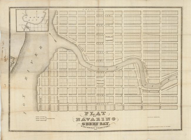
This very rare map is the original survey for Green Bay, Wisconsin. Surveyed and drawn by Albert Ellis for Daniel and Joshua Whitney and Henry Hamilton, listed as proprietors in the title. It is printed on tissue-like paper with the title repeated in ink in the left margin on the verso. The map shows the town as laid out by Daniel Whitney in 1836. Two public squares are surrounded by a fully planned town with named streets and all plots surveyed and numbered. The Fox River bounds the town on the west with the East River bisecting the town. Fort Howard, abandoned in 1853, is shown across the Fox River. At upper left is an inset showing the vicinity of Navarino with part of Green Bay. Today the southern town square is known as Whitney Park.
Daniel Whitney was a New England trader who brought goods to the area by boat as early as 1816. He envisioned a town across the river from Fort Howard as an idea trading village. In 1829 he purchased land from the family of Pierre Langevin, the original land holder who was in the area as early as 1763. Navarino was named in tribute to the Greek seaport, the site of an important battle for Greek independence fought in 1827 between Greek nationalists and the ruling Ottoman Empire.
The rival trading town of Astor was established just to the south by James Doty, an agent for John Jacob Astor. In 1839 the two villages were consolidated into Green Bay. Today, Green Bay's central district occupies the original site of Navarino with many of the original street names still in use.
Albert Ellis came to Wisconsin in 1822 as an advocate for the Oneida Indians. Traveling with the Oneida on their journey west, Ellis worked to negotiate land claims for the Oneida in Wisconsin, including a treaty with the Menominee Indians. Over his life he was a surveyor, journalist, and politician. He founded the Green Bay Intelligencer in 1833.
The map appears to be separately issued as there is no evidence of having been attached to covers as a pocket map. Printed in New York by A.E. Baker's, Lithogry. 8 Wall St. We find only one copy (Newberry Library) and another reportedly in a private collection. Very rare.
References:
Condition: B+
On thin paper, folding. Ink title in left margin bleeds to recto.