Subject: Colonial Louisiana, Mississippi River
Period: 1721 (circa)
Publication:
Color: Hand Color
Size:
22.5 x 19 inches
57.2 x 48.3 cm
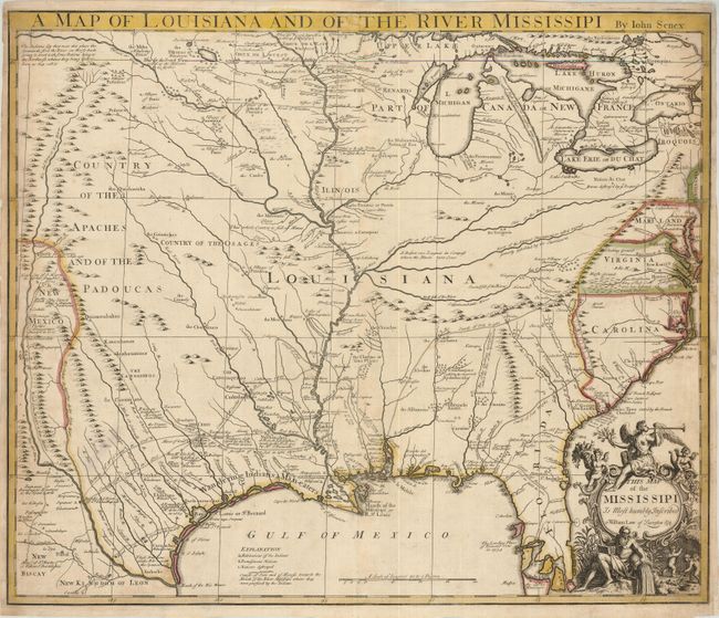
This fascinating map focuses on the French possession of Louisiana, which takes up the region between New Mexico and the Appalachian Mountains. The map is closely derived from Delisle's landmark map of 1718; notably discarding Delisle's notation regarding French claims to Carolina. The map is filled with information on mining and the Indians, including villages, hunting grounds, promiscuous nations and nations destroyed. Early roads and explorers' tracks are meticulously delineated with extensive notations. The map warns of Wandering Indians & Man-eaters along the Texas coast. The allegorical title cartouche celebrates the wealth of the region with a mighty river god, Fame blowing her trumpet atop the cartouche and putti holding richly laden cornucopias and mining.
John Senex was one of the leading English cartographers of the 18th century. He published this map in response to English interest in Louisiana and the Mississippi River valley where Carolina traders were determined to compete with the French in the region. It is interesting to note that Senex dedicated his map to William Law, the father of financier John Law, whose scheme to develop French Louisiana resulted in one the most famous periods of financial turmoil in history - the infamous Mississippi Scheme or Mississippi Bubble.
References: Cumming (SE) #182; Lemmon, Magill & Wiese plt. 21; Wheat (TMW) #100.
Condition: B+
Original color and a good impression. The margins are narrow, but still adequate for framing with toning and some paper restoration at right.