Showing Featured Lots(remove filter)
Filtered by Category:Latin America, Caribbean(Show All Categories)
Catalog Archive
794 lots
Page 1 of 16
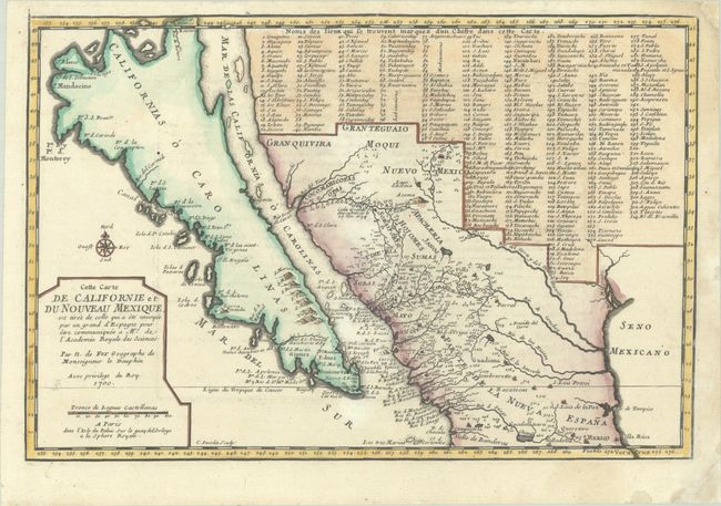
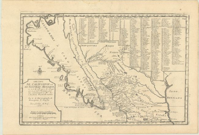
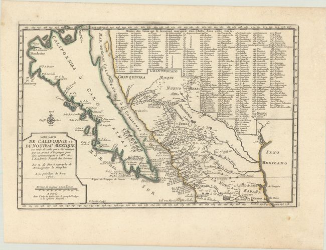
Auction 204, Lot 255
Subject: Southwestern United States & Mexico, California
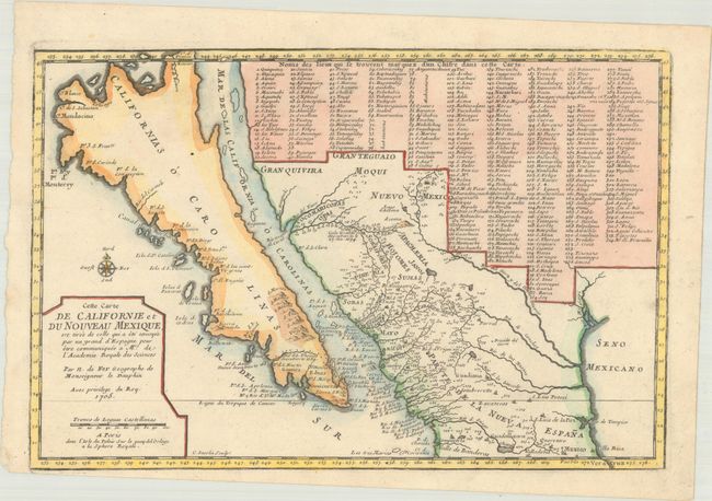
Fer, Nicolas de
Cette Carte de Californie et du Nouveau Mexique, est Tiree de Celle qui a ete Envoyee par un Grand d'Espagne pour etre Communiquee a Mrs. de l'Academie Royale des Sciences, 1700
Size: 13.4 x 9 inches (34 x 22.9 cm)
Estimate: $1,100 - $1,400
De Fer's Important Map of the Island of California - First State
Sold for: $800
Closed on 6/18/2025
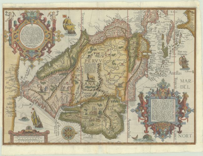
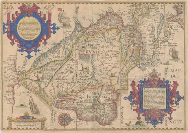
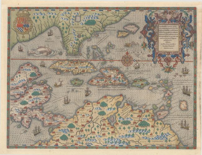
Auction 204, Lot 290
Subject: South America & Caribbean
Linschoten/Langren
Delineatio Omnium Orarum Totius Australis Partis Americae, Dictae Peruvianae, a R. de la Plata, Brasiliam, Pariam, & Castellam Auream..., 1596
Size: 21.3 x 15.1 inches (54.1 x 38.4 cm)
Estimate: $7,000 - $8,500
One of the Most Decorative Early Maps of South America
Sold for: $4,000
Closed on 6/18/2025
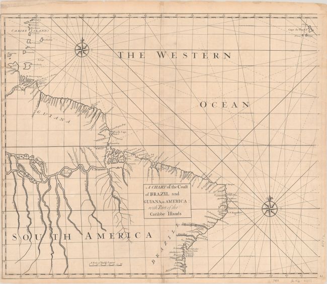
Auction 203, Lot 350
Subject: Eastern South America
Senex, John
[Lot of 2] A Chart of the Coast of Brazil and Guiana, in America: with Part of the Caribbe Islands [and] The East Coast of South America from Todos Sanctos to Sinifundi, 1728
Size: 23.5 x 19.6 inches (59.7 x 49.8 cm)
Estimate: $800 - $950
Rare Charts with Excellent Detail of Amazon River and Rio de la Plata
Unsold
Closed on 4/23/2025
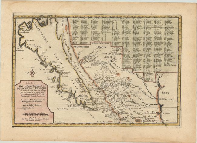
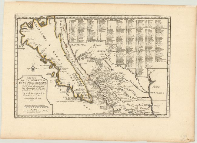
Auction 202, Lot 269
Subject: Southwestern United States & Mexico, California
Fer, Nicolas de
Cette Carte de Californie et du Nouveau Mexique, est Tiree de Celle qui a ete Envoyee par un Grand d'Espagne pour etre Communiquee a Mrs. de l'Academie Royale des Sciences, 1705
Size: 13.3 x 8.8 inches (33.8 x 22.4 cm)
Estimate: $1,000 - $1,300
De Fer's Important Map of the Island of California
Sold for: $750
Closed on 2/12/2025
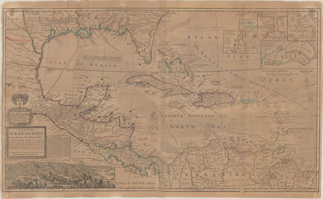
Auction 202, Lot 289
Subject: Gulf of Mexico & Caribbean
Moll, Herman
A Map of the West-Indies or the Islands of America in the North Sea; with ye Adjacent Countries; Explaning What Belongs to Spain, England, France, Holland &c..., 1730
Size: 39.8 x 23.1 inches (101.1 x 58.7 cm)
Estimate: $1,400 - $1,700
Moll's Two-Sheet Map Showing Colonial Possessions with Large View of Mexico City
Sold for: $1,400
Closed on 2/12/2025
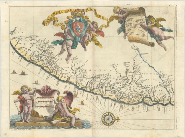
Auction 202, Lot 330
Subject: Eastern Brazil
Horatius, Andreas Antonius
Provincia di Pernambuco, 1698
Size: 19.9 x 14.8 inches (50.5 x 37.6 cm)
Estimate: $700 - $900
A Rare Map of Pernambuco from the "Santa Teresa"
Sold for: $700
Closed on 2/12/2025
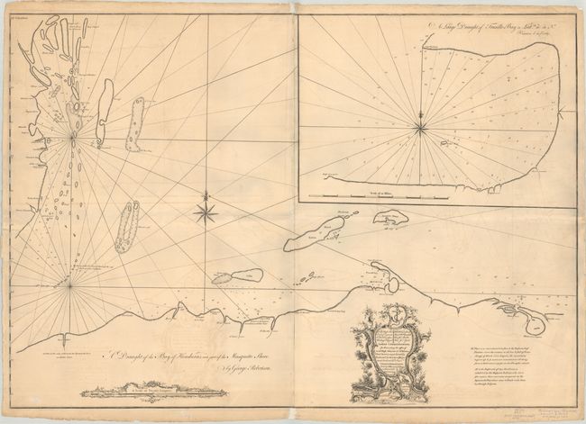
Auction 201, Lot 341
Subject: Belize & Honduras
Mount & Page
A Draught of the Bay of Honduras, and Part of the Musquetto Shore, 1766
Size: 41.2 x 28.6 inches (104.6 x 72.6 cm)
Estimate: $800 - $1,000
Rare Chart of the Coast from Belize to Honduras
Sold for: $2,300
Closed on 11/20/2024
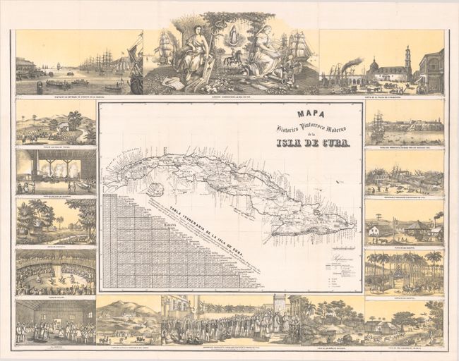
Auction 201, Lot 349
Subject: Cuba
May, Bernardo
Mapa Historico Pintoresco Moderno de la Isla de Cuba, 1853
Size: 22.3 x 17.4 inches (56.6 x 44.2 cm)
Estimate: $1,300 - $1,600
Rare Map of Cuba Surrounded by Vignettes
Sold for: $950
Closed on 11/20/2024
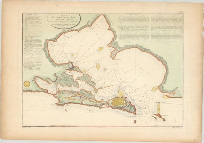
Auction 201, Lot 356
Subject: San Juan, Puerto Rico
Depot de la Marine
Plan du Principal Port de l'Ile de Porto Rico Leve en 1794..., 1801
Size: 22.1 x 15.8 inches (56.1 x 40.1 cm)
Estimate: $1,000 - $1,300
Rare Chart of San Juan
Sold for: $850
Closed on 11/20/2024
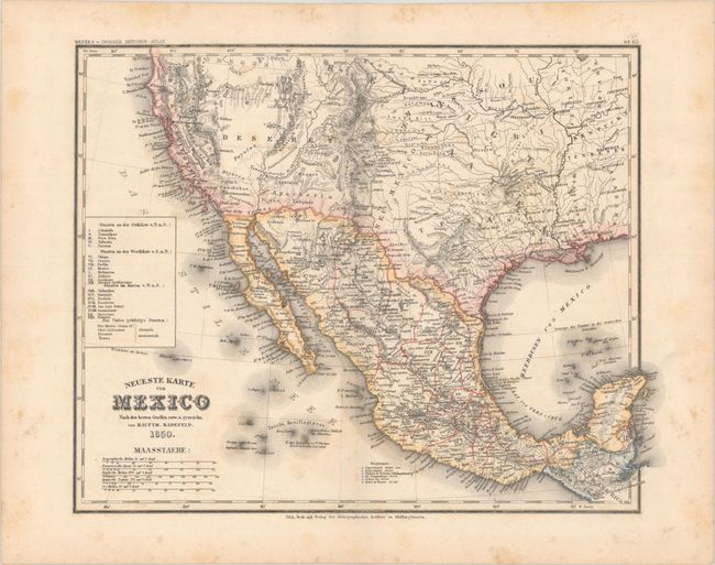
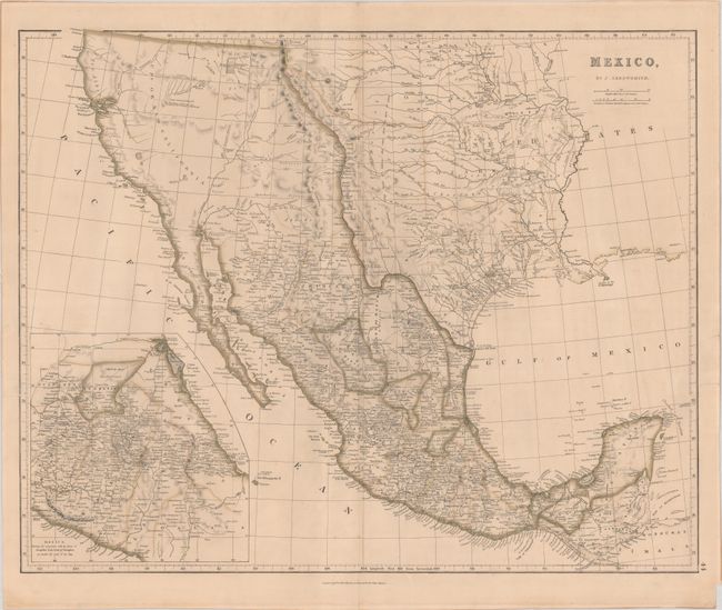
Auction 198, Lot 261
Subject: United States & Mexico
Radefeld, Carl Christian Franz
Neueste Karte von Mexico nach den Besten Quellen..., 1850
Size: 14.8 x 11.6 inches (37.6 x 29.5 cm)
Estimate: $750 - $900
Rare Map Showing The Proposed State of Deseret
Sold for: $500
Closed on 6/19/2024
Auction 197, Lot 313
Subject: Southwestern United States & Mexico, California
Fer, Nicolas de
Cette Carte de Californie et du Nouveau Mexique, est Tiree de Celle qui a ete Envoyee par un Grand d'Espagne pour Etre Communiquee a Mrs. de l'Academie Royale des Sciences, 1705
Size: 13.4 x 8.9 inches (34 x 22.6 cm)
Estimate: $1,100 - $1,400
De Fer's Important Map of the Island of California
Sold for: $900
Closed on 4/24/2024
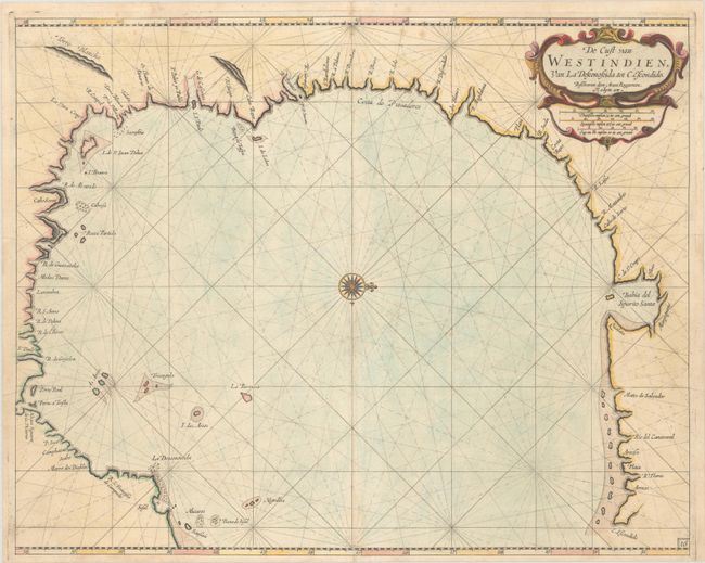
Auction 197, Lot 327
Subject: Western Gulf of Mexico, Texas
Roggeveen, Arent
De Cust van Westindien, van la Desconoscida, tot C. Escondido, 1680
Size: 20.3 x 16.2 inches (51.6 x 41.1 cm)
Estimate: $11,000 - $14,000
"The Most Detailed Chart of the Present-Day Texan Coastline" - Burden
Sold for: $8,000
Closed on 4/24/2024
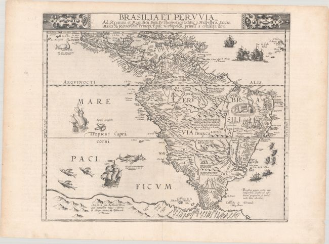
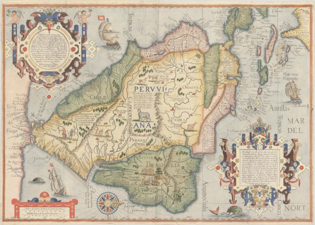
Auction 197, Lot 357
Subject: South America
Jode, Cornelis de
Brasilia et Peruvia ad Strenuu et Magnificu Dnm. D. Theodoricu Echter..., 1593
Size: 16.6 x 14.1 inches (42.2 x 35.8 cm)
Estimate: $9,500 - $12,000
One of the Earliest Maps of the South American Continent
Unsold
Closed on 4/24/2024
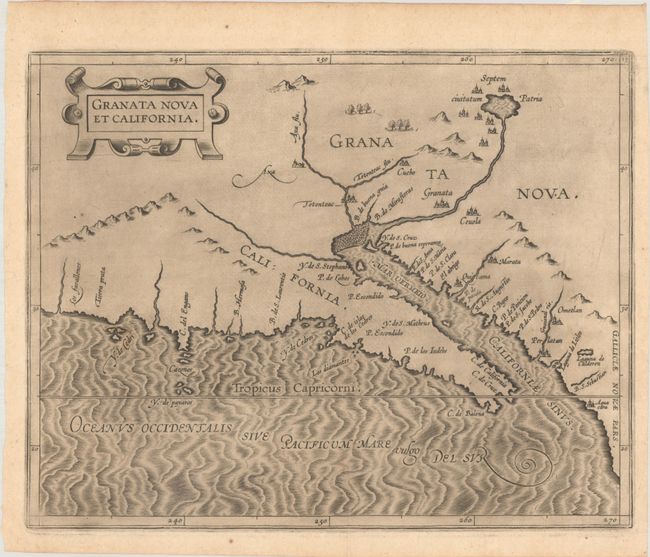
Auction 196, Lot 283
Subject: Southwestern United States & Mexico
Wytfliet, Cornelis
Granata Nova et California, 1597
Size: 11.4 x 9.1 inches (29 x 23.1 cm)
Estimate: $2,750 - $3,500
First Printed Map to Focus on California and the Southwest
Sold for: $2,000
Closed on 2/7/2024
Auction 196, Lot 285
Subject: Southwestern United States & Mexico, California
Fer, Nicolas de
Cette Carte de Californie et du Nouveau Mexique, est Tiree de Celle qui a ete Envoyee par un Grand d'Espagne pour etre Communiquee a Mrs de l'Academie Royale des Sciences, 1705
Size: 13.5 x 8.9 inches (34.3 x 22.6 cm)
Estimate: $1,100 - $1,400
De Fer's Important Map of the Island of California
Sold for: $800
Closed on 2/7/2024
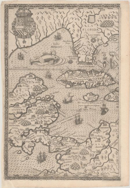
Auction 196, Lot 302
Subject: Gulf of Mexico & Caribbean, Florida
Bry, Theodore de
[Western Half - Occidentalis Americae Partis, vel, Earum Regionum quas Christophorus Columbus Primu Detexit Tabula Chorographicae Multorum Auctorum Scriptis...], 1594
Size: 8.6 x 13.1 inches (21.8 x 33.3 cm)
Estimate: $2,000 - $2,300
Western Portion of De Bry's Superb Map of the Southeastern US, Caribbean & Northern South America
Sold for: $1,900
Closed on 2/7/2024

Auction 195, Lot 358
Subject: Southwestern United States & Mexico, California
Fer, Nicolas de
Cette Carte de Californie et du Nouveau Mexique, est Tiree de Celle qui a ete Envoyee par un Grand d'Espagne pour Etre Communiquee a Mrs. de l'Academie Royale des Sciences, 1705
Size: 13.4 x 8.9 inches (34 x 22.6 cm)
Estimate: $1,200 - $1,500
De Fer's Important Map of the Island of California
Unsold
Closed on 11/15/2023
Auction 195, Lot 422
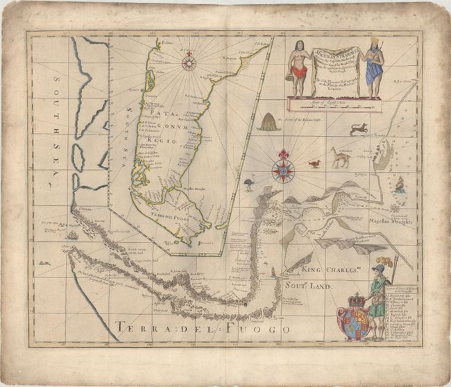
Subject: Strait of Magellan
Thornton, John
A New Mapp of Magellan Straights Discovered by Capp: John Narbrough (Comander Then of His Majesties Ship the Sweepstakes) as He Sayled Through the Sade Straights, 1700
Size: 20.4 x 16.4 inches (51.8 x 41.7 cm)
Estimate: $2,000 - $2,300
Scarce Map of Strait of Magellan Based on Narborough's Expedition
Sold for: $2,750
Closed on 11/15/2023

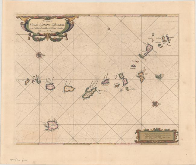
Auction 194, Lot 336
Subject: Lesser Antilles
Roggeveen, Arent
Pascaerte vande Caribes Eylanden, van 't Eylant Granadillos, tot 't Eylant Anguilla, 1675
Size: 20.1 x 16.2 inches (51.1 x 41.1 cm)
Estimate: $3,000 - $3,750
Rare First Edition of Dutch Sea Chart in Full Contemporary Color
Sold for: $2,200
Closed on 9/13/2023
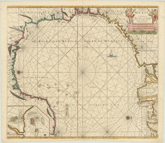
Auction 193, Lot 328
Subject: Gulf of Mexico
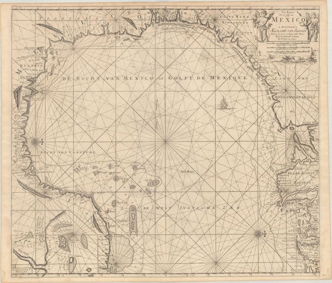
Keulen, Gerard van
Pas Kaart van de Golff van Mexico, 1734
Size: 23 x 20.3 inches (58.4 x 51.6 cm)
Estimate: $1,400 - $1,700
The First Sea Chart of the Western Portion of the Gulf of Mexico
Sold for: $1,000
Closed on 6/21/2023
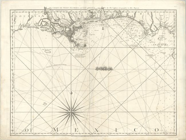
Auction 193, Lot 329
Subject: Gulf of Mexico
Jefferys/Laurie & Whittle
The Coast of West Florida and Louisiana, 1794
Size: 24.8 x 19.3 inches (63 x 49 cm)
Estimate: $1,100 - $1,400
Important 18th Century Map of Gulf Coast
Sold for: $550
Closed on 6/21/2023
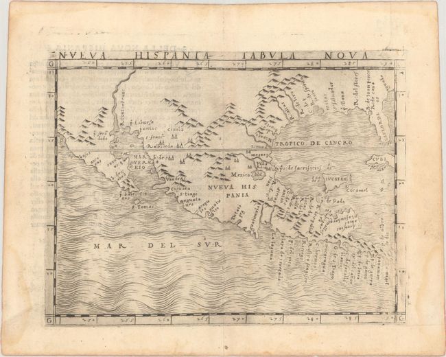
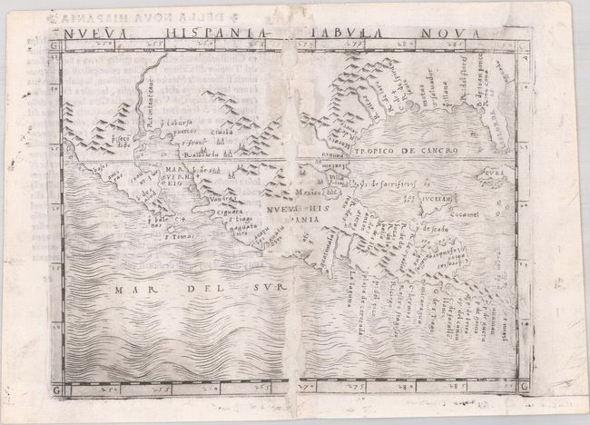
Auction 192, Lot 313
Subject: Southern United States, Mexico & Central America
Gastaldi, Giacomo
Nueva Hispania Tabula Nova, 1548
Size: 6.8 x 5 inches (17.3 x 12.7 cm)
Estimate: $3,250 - $4,000
The First Copperplate Map Devoted to North America
Sold for: $2,400
Closed on 4/26/2023
Auction 192, Lot 345
Subject: Lesser Antilles
Roggeveen, Arent
Pascaerte vande Caribes Eylanden, van 't Eylant Granadillos, tot 't Eylant Anguilla, 1675
Size: 20.1 x 16.2 inches (51.1 x 41.1 cm)
Estimate: $3,500 - $4,250
Rare First Edition of Dutch Sea Chart in Full Contemporary Color
Unsold
Closed on 4/26/2023
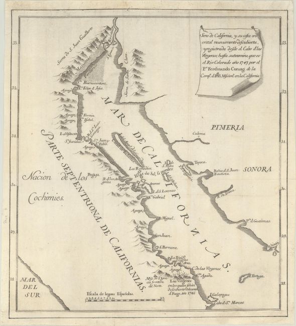
Auction 191, Lot 362
Subject: Gulf of California
Venegas, Miguel (Padre)
Seno de California, y su Costa Oriental Nuevamente Descubierta, y Registrada Desde el Cabo et las Virgenes..., 1747
Size: 11.4 x 12.5 inches (29 x 31.8 cm)
Estimate: $1,200 - $1,500
The Map That Put an End to the Island of California Myth
Sold for: $650
Closed on 2/8/2023
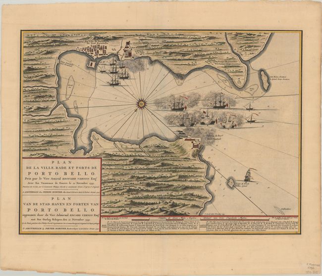
Auction 191, Lot 368
Subject: Portobelo, Panama
Mortier, Pierre
Plan de la Ville Rade et Forts de Porto Bello... / Plan van de Stad Haven en Forten van Porto Bello..., 1740
Size: 22.4 x 16.3 inches (56.9 x 41.4 cm)
Estimate: $1,600 - $1,900
Rare Chart of the Battle of Portobello
Sold for: $900
Closed on 2/8/2023

Auction 191, Lot 375
Subject: Gulf of Mexico
Jefferys/Laurie & Whittle
The Coast of West Florida and Louisiana, 1794
Size: 24.8 x 19.3 inches (63 x 49 cm)
Estimate: $1,400 - $1,700
Important 18th Century Map of Gulf Coast
Unsold
Closed on 2/8/2023
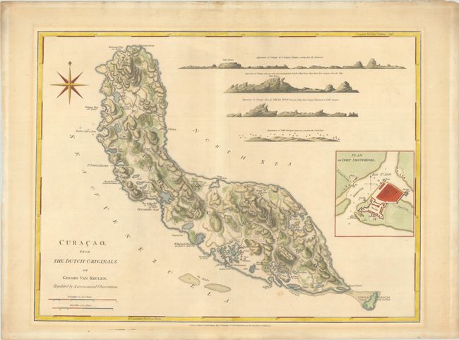
Auction 191, Lot 401
Subject: Curacao
Jefferys/Sayer
Curacao, from the Dutch Originals, of Gerald Van Keulen, Regulated by Astronomical Observations, 1775
Size: 24.3 x 18.4 inches (61.7 x 46.7 cm)
Estimate: $1,900 - $2,200
Sold for: $1,400
Closed on 2/8/2023
Auction 191, Lot 403
Subject: South America & Caribbean
Linschoten/Langren
Delineatio Omnium Orarum Totius Australis Partis Americae, Dictae Peruvianae, a R. de la Plata, Brasiliam, Pariam, & Castellam Auream..., 1596
Size: 22 x 15.4 inches (55.9 x 39.1 cm)
Estimate: $5,500 - $7,000
One of the Most Decorative Early Maps of South America
Sold for: $4,000
Closed on 2/8/2023
Auction 189, Lot 274
Subject: Southern United States & Mexico
Gastaldi, Giacomo
Nueva Hispania Tabula Nova, 1548
Size: 6.8 x 5 inches (17.3 x 12.7 cm)
Estimate: $2,750 - $3,500
The First Copperplate Map Devoted to North America
Sold for: $1,400
Closed on 9/14/2022

Auction 189, Lot 284
Subject: Portobelo, Panama
Mortier, Pierre
Plan de la Ville Rade et Forts de Porto Bello... / Plan van de Stad Haven en Forten van Porto Bello..., 1740
Size: 22.4 x 16.3 inches (56.9 x 41.4 cm)
Estimate: $1,900 - $2,200
Rare Chart of the Battle of Portobello
Unsold
Closed on 9/14/2022
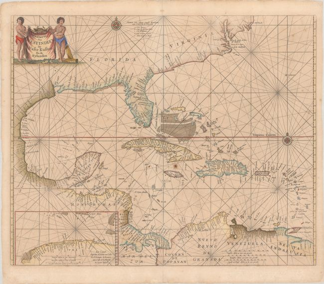
Auction 189, Lot 287
Subject: Gulf of Mexico & Caribbean
Goos, Pieter
Pascaerte van Westindien de Vaste Kusten en de Eylanden, 1666
Size: 21.5 x 17.6 inches (54.6 x 44.7 cm)
Estimate: $2,000 - $2,300
Scarce Sea Chart with Interesting Depiction of the Coastline of the US
Sold for: $1,500
Closed on 9/14/2022
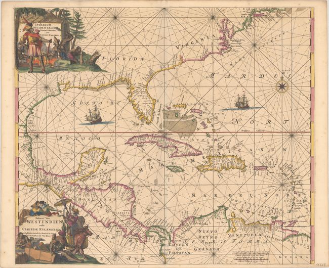
Auction 189, Lot 288
Subject: Gulf of Mexico & Caribbean
Wit, Frederick de
Indiarum Occidentalium Tractus Littorales cum Insulis Caribicis / Pascaert van Westindien ende Caribise Eylanden, 1675
Size: 22.1 x 19.1 inches (56.1 x 48.5 cm)
Estimate: $2,300 - $2,500
A Magnificent Sea Chart of the West Indies in Full Contemporary Color
Sold for: $1,900
Closed on 9/14/2022
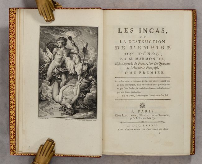
Auction 188, Lot 326
Subject: Peru, Natives
[2 Volumes] Les Incas, ou la Destruction de l'Empire du Perou..., 1777
Size: 5.4 x 8.5 inches (13.7 x 21.6 cm)
Estimate: $1,100 - $1,400
Includes Manuscript Letter by Author and Proof Plates
Sold for: $950
Closed on 6/22/2022
Auction 187, Lot 298
Subject: Southwestern United States & Mexico, California
Fer, Nicolas de
Cette Carte de Californie et du Nouveau Mexique, est Tiree de Celle qui a ete Envoyee par un Grand d'Espagne..., 1700
Size: 13.4 x 8.8 inches (34 x 22.4 cm)
Estimate: $1,200 - $1,500
De Fer's Important Map of the Island of California
Sold for: $900
Closed on 4/27/2022
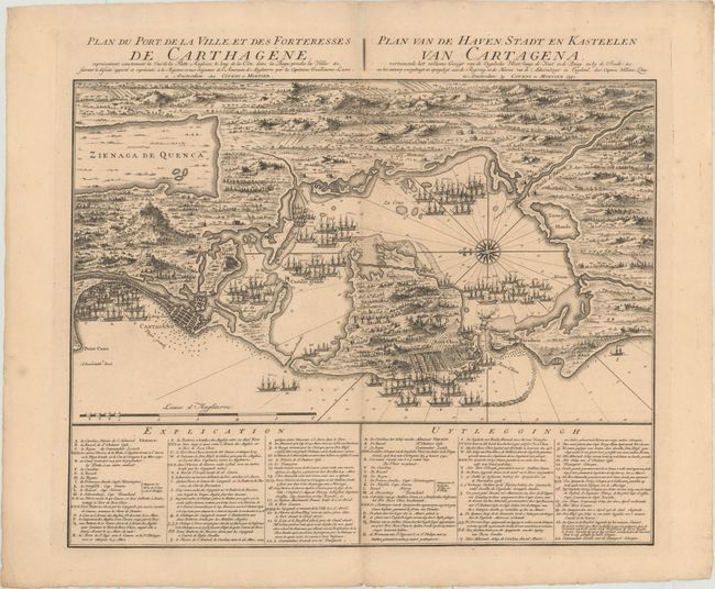
Auction 187, Lot 335
Subject: Cartagena, Colombia
Covens & Mortier
Plan du Port de la Ville, et des Forteresses de Carthagene... / Plan van de Haven, Stadt en Kasteelen van Cartagena..., 1741
Size: 22.4 x 17.8 inches (56.9 x 45.2 cm)
Estimate: $800 - $1,000
Scarce Plan of English Siege of Cartagena During War of Jenkins' Ear
Sold for: $650
Closed on 4/27/2022
Auction 186, Lot 341
Subject: Southwestern United States & Mexico, California
Fer, Nicolas de
Cette Carte de Californie et du Nouveau Mexique, 1700
Size: 13.4 x 8.9 inches (34 x 22.6 cm)
Estimate: $1,200 - $1,500
De Fer's Important Map of the Island of California
Sold for: $1,100
Closed on 2/9/2022
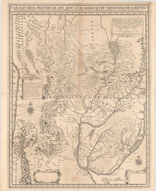
Auction 186, Lot 385
Subject: Central South America, Paraguay
Paraquariae Provinciae Soc. Jesu cum Adjacentib. Novissima Descriptio..., 1722
Size: 21.9 x 28.4 inches (55.6 x 72.1 cm)
Estimate: $4,000 - $4,750
Pre-Publication Proof of Extremely Rare Jesuit Map of Paraguay
Unsold
Closed on 2/9/2022
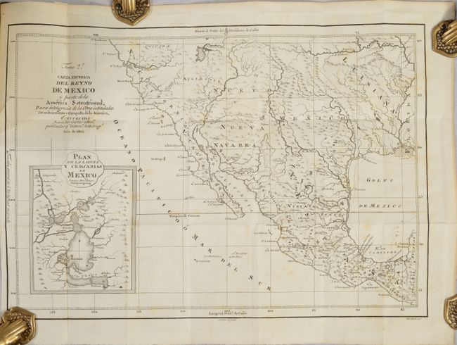
Auction 185, Lot 358
Subject: Southwestern United States & Mexico
[Map in Book] Carta Esferica del Reyno de Mexico y Parte de la America Setentrional... [in] Descubrimiento y Conquista de la America, o Compendio de la Historia General del Nuevo Mundo ... Tomo II, 1803
Size: 18.1 x 12.5 inches (46 x 31.8 cm)
Estimate: $1,800 - $2,200
A Scarce Spanish Map of the Southwest
Sold for: $3,250
Closed on 11/17/2021
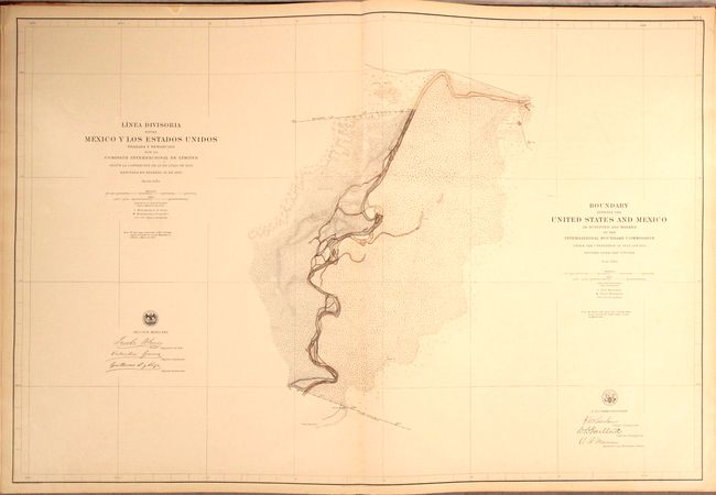
Auction 184, Lot 370
Subject: Southwestern United States & Mexico, Atlas
[2 Volumes] Boundary Between the United States and Mexico, as Surveyed and Marked by the International Boundary Commission... [and] Linea Divisoria Entre Mexico y los Estados Unidos..., 1898
Size: 22 x 29 inches (55.9 x 73.7 cm)
Estimate: $2,400 - $3,000
Mammoth Atlas Volumes from the Mexican Boundary Resurvey
Sold for: $1,600
Closed on 9/15/2021
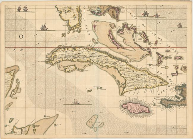
Auction 184, Lot 385
Subject: Greater Antilles
Popple, Henry
[A Map of the British Empire in America (Sheet 14) - Cuba, Bahamas, Jamaica], 1733
Size: 26.9 x 19.3 inches (68.3 x 49 cm)
Estimate: $2,000 - $2,300
Popple Sheet in Full Contemporary Color
Sold for: $1,700
Closed on 9/15/2021
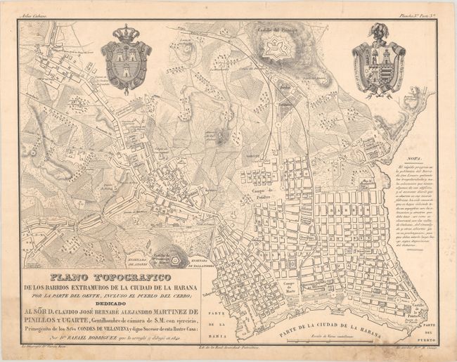
Auction 184, Lot 389
Subject: Havana & Batabano, Cuba
[Lot of 3] Plano Topografico de los Barrios Extramuros de la Ciudad de la Habana... [and] Plano Topografico del Puerto y Bahia de la Habana... [and] Plano Topografico Historico Estadistico del Pueblo del Batabano..., 1841
Size: 20 x 15.6 inches (50.8 x 39.6 cm)
Estimate: $4,000 - $4,750
Three Rare Maps from the First Cuban Atlas Published in Cuba
Sold for: $3,000
Closed on 9/15/2021
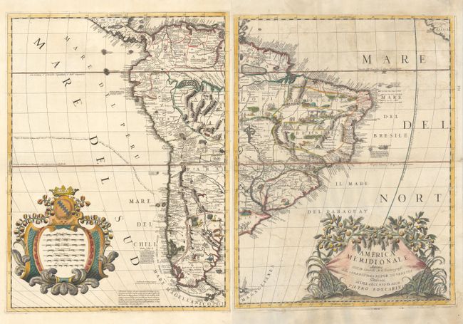
Auction 184, Lot 397
Subject: South America
Coronelli, Vincenzo Maria
[On 2 Sheets] America Meridionale, 1691
Size: 17.8 x 23.4 inches (45.2 x 59.4 cm)
Estimate: $1,500 - $1,800
Coronelli's Influential and Decorative Map of South America
Sold for: $900
Closed on 9/15/2021
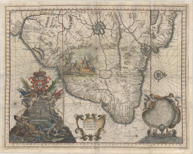
Auction 184, Lot 409
Subject: Brazil
Santa Teresa, J. J. de
Il Regno del Brasile Parte Nobilissima del Mondo Nuovo..., 1698
Size: 22.8 x 17.7 inches (57.9 x 45 cm)
Estimate: $1,500 - $1,800
A Rare Map of Brazil from the Santa Teresa
Sold for: $1,050
Closed on 9/15/2021
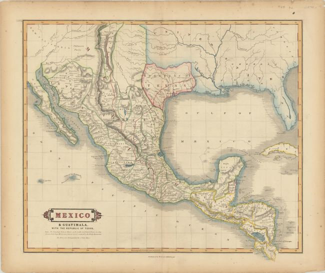
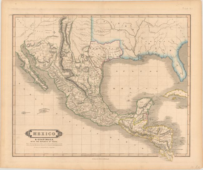
Auction 183, Lot 248
Subject: Southern United States, Mexico & Central America, Texas
Lizars, William Home
Mexico & Guatimala, with the Republic of Texas, 1838
Size: 19.2 x 16.6 inches (48.8 x 42.2 cm)
Estimate: $1,100 - $1,400
One of the Few Maps to Include "Republic" in the Title
Sold for: $850
Closed on 6/9/2021
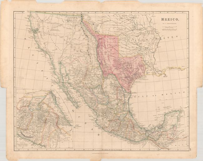
Auction 183, Lot 253
Subject: Southwestern United States & Mexico, Texas
Arrowsmith, John
Mexico, 1842
Size: 23.6 x 18.9 inches (59.9 x 48 cm)
Estimate: $1,600 - $1,900
Features the Republic of Texas in its Largest Configuration
Sold for: $1,200
Closed on 6/9/2021
Auction 183, Lot 260
Subject: Gulf of Mexico & Caribbean
Bry, Theodore de
Occidentalis Americae Partis, vel, Earum Regionum quas Christophorus Columbus Primu Detexit Tabula Chorographicae Multorum Auctorum Scriptis..., 1594
Size: 17.1 x 12.9 inches (43.4 x 32.8 cm)
Estimate: $7,500 - $9,000
De Bry's Superb Map of the Southeastern US, Caribbean & Northern South America
Sold for: $5,500
Closed on 6/9/2021
Auction 183, Lot 268
Subject: South America & Caribbean
Linschoten/Langren
Delineatio Omnium Orarum Totius Australis Partis Americae, Dictae Peruvianae, a R. de la Plata, Brasiliam, Pariam, & Castellam Auream..., 1596
Size: 21.8 x 15.3 inches (55.4 x 38.9 cm)
Estimate: $7,000 - $8,500
One of the Most Decorative Early Maps of South America
Sold for: $5,500
Closed on 6/9/2021
Auction 182, Lot 351
Subject: Southern United States, Mexico & Central America, Texas
Lizars, William Home
Mexico & Guatimala, with the Republic of Texas, 1838
Size: 19.7 x 16.4 inches (50 x 41.7 cm)
Estimate: $1,000 - $1,300
One of the Few Maps to Include "Republic" in the Title
Sold for: $950
Closed on 4/28/2021
Auction 182, Lot 385
Subject: Gulf of Mexico
Keulen, Gerard van
Pas Kaart van de Golff van Mexico, 1734
Size: 23.1 x 20.3 inches (58.7 x 51.6 cm)
Estimate: $1,400 - $1,700
The First Sea Chart of the Western Portion of the Gulf of Mexico
Sold for: $900
Closed on 4/28/2021
Auction 181, Lot 306
Subject: Southwestern United States & Mexico, Texas
Arrowsmith, John
Mexico, 1842
Size: 23.6 x 18.9 inches (59.9 x 48 cm)
Estimate: $1,600 - $1,900
Features the Republic of Texas in its Largest Configuration
Sold for: $1,400
Closed on 2/10/2021
794 lots
Page 1 of 16