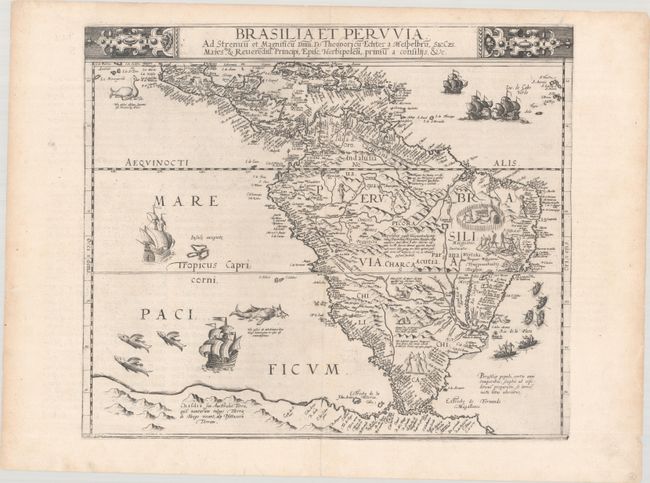
Subject: South America
Period: 1593 (published)
Publication: Speculum Orbis Terrae
Color: Black & White
Size:
16.6 x 14.1 inches
42.2 x 35.8 cm
This is an exquisite example of Cornelis de Jode's map of South America, which is one of the earliest to depict the continent on a separate map. It presents excellent detail of the known regions, particularly along the coastlines, based upon both Spanish and Portuguese explorations in the region. The cartography is based primarily upon Petrus Plancius' eighteen-sheet map of the world that was published in Amsterdam the year before. Of particular interest is the depiction of the Strait of Magellan, here named Estrecho de la Victoria and Canal de todo los Santos, which were names used by Antonio Pigafetta in his description of Magellan's voyage through the strait. The interior regions are boldly filled with speculative mountain ranges, complex river systems, copious notations, and fascinating illustrations of natives, exotic wildlife, and a battle scene in Brazil. The map extends as far north as Central America and the Caribbean and south to a vast southern landmass that incorporates Tierra del Fuego. De Jode completes his composition with decorative elements not seen on Plancuis' map, including what appear to be flying fish, a penguin, and a furry sea monster in the Pacific Ocean. Dedicated to Julius Echter von Mespelbrunn, Prince-Bishop of Wurzburg.
This is the de Jode family's second map of South America, the first being published in 1578 by his father Gerard. It was published in the revised and updated edition of the Speculum, which featured 10 new plates engraved by Cornelis including this map. While neither edition of the Speculum had much commercial success, de Jode maps are often regarded as superior in both design and cartographic detail to his more successful competitor, Abraham Ortelius.
References: Shirley (BL Atlases) T.JOD-1c.; Van der Krogt (Vol. III) #9800:32B
Condition: A
A crisp impression on a clean bright sheet with archival reinforcement along the centerfold to repair a few tiny separations. There are a few tiny edge tears confined to the far blank margins and remnants of hinge tape along the top sheet edge on verso.