Subject: Southwestern United States & Mexico, California
Period: 1705 (dated)
Publication: Atlas Curieux
Color: Hand Color
Size:
13.4 x 8.9 inches
34 x 22.6 cm
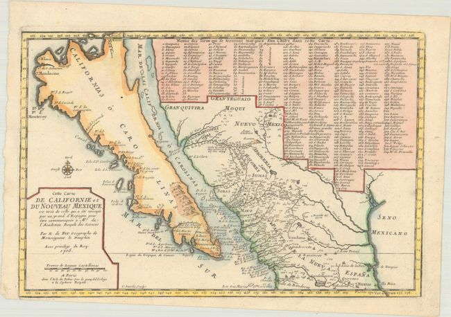
This small map is very important in the cartographic history of California and the Southwest. Ironically it is one of the only maps of the period to focus on the island of California, and the first map to show the discoveries of Father Eusebio Kino, the man who disproved that California island theory. According to Wagner, the map is purportedly based on a manuscript drawn by Father Kino in 1696. The island is named Californias o Carolinas and a number of new place names are introduced here for the first time, including the interestingly titled Ba. d. las 11000 Virgenes (Bay of 11,000 Virgins). Numerous place names are shown in what is now the southwestern part of the United States, including Santa Fe, Acoma, and Casa Grande. Additionally, 314 different places are located and keyed to a table that fills a large portion of the map; thus presenting remarkable documentation of the native settlements in the region. Engraved by Inselin, who also engraved Kino's famous map.
References: McLaughlin #134; Tooley (America) p.126, #62; Wagner (NW) #462; Wheat (TMW) #78.
Condition: A
On a clean sheet of watermarked paper. There is a somewhat narrow margin at lower left from the paper having been slightly misaligned with the engraved plate at the time of pressing.