Subject: Strait of Magellan
Period: 1700 (circa)
Publication: Atlas Maritimus
Color: Hand Color
Size:
20.4 x 16.4 inches
51.8 x 41.7 cm
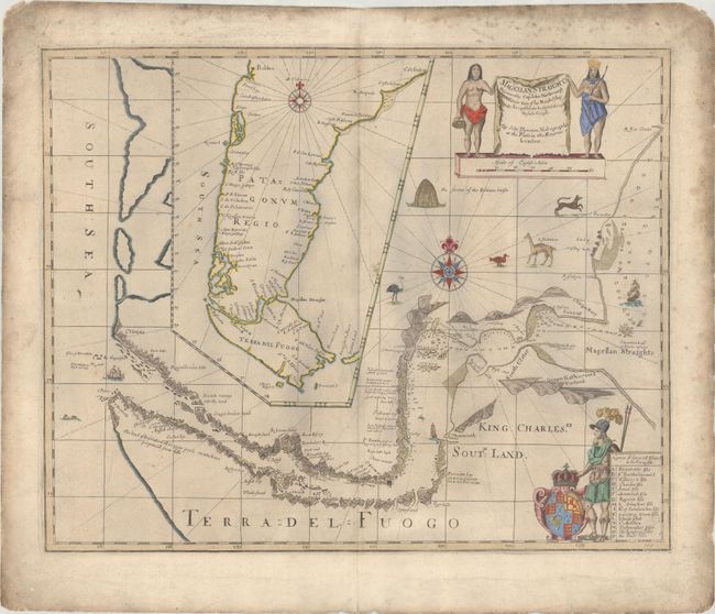
In 1670, John Narborough was the first Englishman to sail through the Strait of Magellan in both directions; thus demonstrating the falsity of the accepted wisdom that the wind and currents would prevent any eastward passage of the strait. He had been commissioned by James, Duke of York (later James II), to sail to South America to investigate potential trade possibilities. Narborough's expedition proved that a profitable trade with South America was possible, and this set the course of Britain's foreign policy for the next half century. Narborough published his journal of the voyage in An Account of Several Late Voyages… in 1694. His description of the Strait of Magellan provided the basis for British charts of the strait until the time of Captain Cook. This map is closely based on the map from Narborough's book, and provides a detailed view of the tortuous course of the strait with soundings and safe anchorages carefully noted. There are several notations along the coasts describing the countryside. A large inset map shows Patagonia and Tierra del Fuego. There are a number of embellishments, including the English royal coat of arms of Charles II, a European soldier, Native Americans, ships, animals such as a rhea and guanaco, and a native American dwelling. A later edition was published by Samuel Thornton, John Thornton's brother, who took over John's business in 1706, and then re-published the map with his own imprint.
Both the original Narborough map and the Thornton re-issues are extremely scarce. We have only found one record of either states of the Thornton map being on the market in the past 25 years.
References: cf. Shirley (BL Atlases) M.THOR-1b #28.
Condition: B+
A crisp impression on a lightly toned, double-thick sheet with soiling that is more prominent along the edges of the sheet, and small chips and tears along the edges as well. There are some grayish shadows on the map image that are caused by our scanner and do not appear on the map itself.