Filtered by Category:Canada(Show All Categories)
Showing results for:Auction 176
Catalog Archive
25 lots
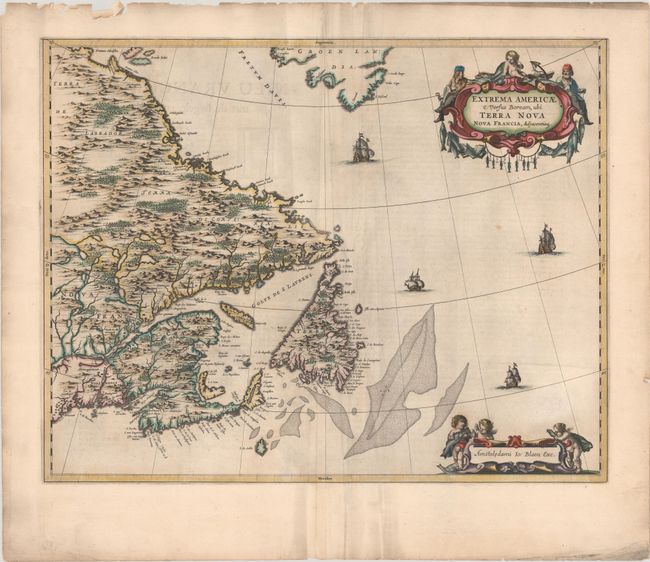
Auction 176, Lot 79
Subject: Eastern Canada
Blaeu, Johannes
Extrema Americae Versus Boream, ubi Terra Nova Nova Francia, Adjacentiaqs, 1664
Size: 22.3 x 17.5 inches (56.6 x 44.5 cm)
Estimate: $1,900 - $2,200
Blaeu's Only Map of Canada, Showing the Canadian Maritimes
Unsold
Closed on 2/12/2020
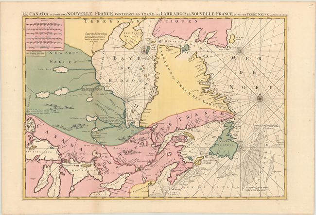
Auction 176, Lot 80
Subject: Eastern Canada, Great Lakes
Mortier, Pierre
Le Canada ou Partie de la Nouvelle France, Contenant la Terre de Labrador la Nouvelle France, les Isles de Terre Neuve. De Nostre Dame &c:, 1693
Size: 30.8 x 21.5 inches (78.2 x 54.6 cm)
Estimate: $1,600 - $1,900
Sold for: $1,300
Closed on 2/12/2020
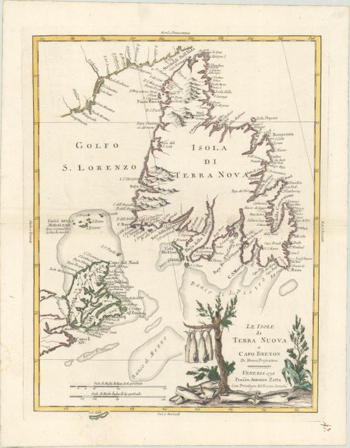
Auction 176, Lot 81
Subject: Eastern Canada
Zatta, Antonio
Le Isole di Terra Nuova e Capo Breton di Nuova Projezione, 1778
Size: 12.5 x 16.5 inches (31.8 x 41.9 cm)
Estimate: $275 - $350
Sold for: $210
Closed on 2/12/2020
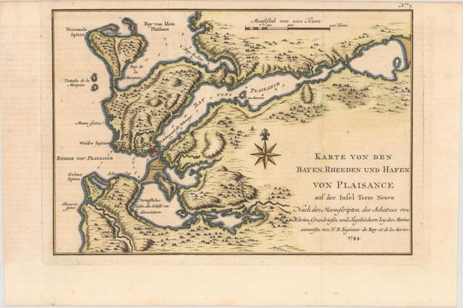
Auction 176, Lot 82
Subject: Newfoundland, Canada
Bellin, Jacques Nicolas
Karte von den Bayen, Rheeden und Hafen von Plaisance auf der Insel Terre Neuve..., 1744
Size: 11.3 x 7.7 inches (28.7 x 19.6 cm)
Estimate: $100 - $130
Sold for: $75
Closed on 2/12/2020
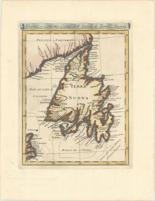
Auction 176, Lot 83
Subject: Newfoundland, Canada
Rossi, Veremondo
Nuova, e Corretta Carta dell' Isola di Terra Nuova, 1763
Size: 6.4 x 8.2 inches (16.3 x 20.8 cm)
Estimate: $160 - $190
Sold for: $120
Closed on 2/12/2020
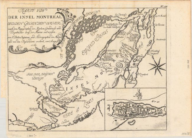
Auction 176, Lot 84
Subject: Montreal, Canada
Bellin, Jacques Nicolas
Karte von der Insel Montreal und den Gegen den Umher nach den Manuscripten der Karten..., 1760
Size: 11.3 x 8.8 inches (28.7 x 22.4 cm)
Estimate: $160 - $190
Sold for: $160
Closed on 2/12/2020
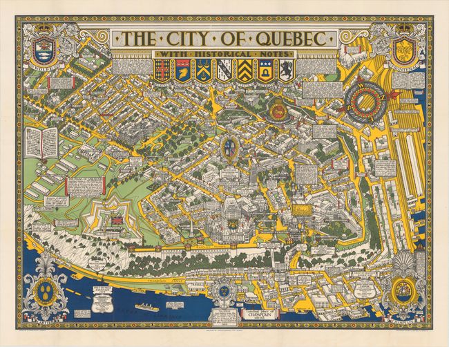
Auction 176, Lot 85
Subject: Quebec City, Canada
The City of Quebec with Historical Notes, 1932
Size: 33.3 x 25.1 inches (84.6 x 63.8 cm)
Estimate: $200 - $250
Sold for: $180
Closed on 2/12/2020
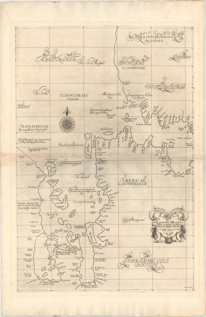
Auction 176, Lot 86
Subject: Hudson Bay, Canada
Dudley, Robert (Sir)
Carta Particolare dello Istreto e Mare Iscoperto da Heno. Hudson Ingilese nel 1611..., 1661
Size: 18.7 x 27.9 inches (47.5 x 70.9 cm)
Estimate: $4,750 - $5,500
The First Printed Chart of Hudson Bay and Hudson Strait
Sold for: $3,000
Closed on 2/12/2020
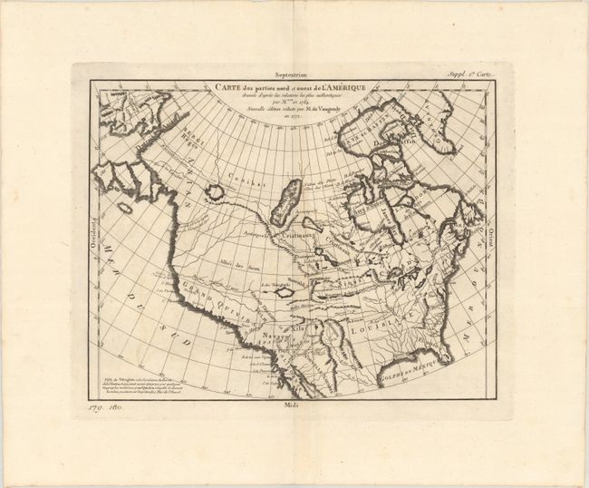
Auction 176, Lot 87
Subject: Colonial United States & Canada
Robert de Vaugondy, Didier
Carte des Parties Nord et Ouest de l'Amerique Dressee d'Apres les Relations les Plus Authentiques..., 1772
Size: 14.4 x 11.3 inches (36.6 x 28.7 cm)
Estimate: $180 - $220
Sold for: $220
Closed on 2/12/2020
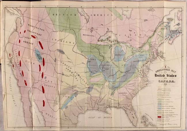
Auction 176, Lot 88
Subject: United States & Canada, World
Hitchcock, Edward
[Maps with Report] A Geological Map of the United States and Canada [and] Outline of the Geology of the Globe, 1853
Size: 5.5 x 8.8 inches (14 x 22.4 cm)
Estimate: $1,200 - $1,500
Includes Hitchcock's First Geological Map of the United States
Sold for: $850
Closed on 2/12/2020
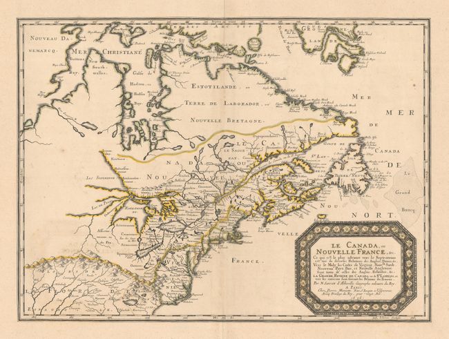
Auction 176, Lot 89
Subject: Colonial Eastern United States & Canada
Sanson/Mariette
Le Canada, ou Nouvelle France, &c. ce qui est le Plus Advance vers le Septentrion est Tire de Diverses Relations des Anglois, Danois, &c..., 1656
Size: 21.3 x 15.6 inches (54.1 x 39.6 cm)
Estimate: $4,000 - $5,000
Keystone Map for Great Lakes Collections
Sold for: $2,000
Closed on 2/12/2020
Auction 176, Lot 90
Subject: Colonial Eastern United States & Canada
Moll, Herman
A New and Exact Map of the Dominions of the King of Great Britain on ye Continent of North America..., 1715
Size: 24.1 x 39.9 inches (61.2 x 101.3 cm)
Estimate: $17,000 - $20,000
Moll's Rare and Highly Desirable "Beaver Map" in Contemporary Color
Sold for: $12,000
Closed on 2/12/2020
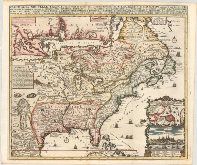
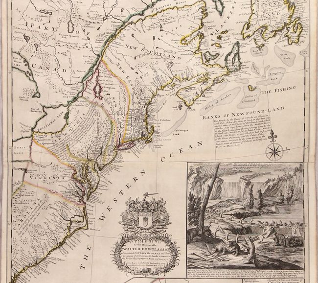
Auction 176, Lot 91
Subject: Colonial Eastern United States & Canada
Chatelain, Henry Abraham
Carte de la Nouvelle France, ou se voit le Cours des Grandes Rivieres de S. Laurens & de Mississipi Aujour d'hui S. Louis, aux Environs des-quelles se Trouvent les Etats, Pais, Nations, Peuples &c..., 1719
Size: 19.3 x 16.6 inches (49 x 42.2 cm)
Estimate: $3,000 - $3,750
One of the Most Informative 18th Century Maps of the French Possessions in North America
Sold for: $2,750
Closed on 2/12/2020
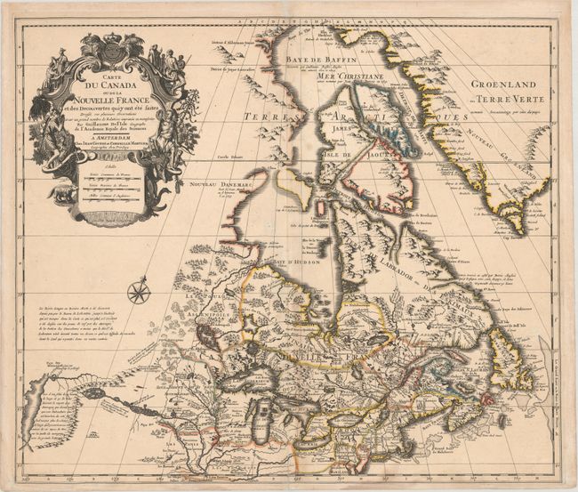
Auction 176, Lot 92
Subject: Colonial Eastern United States & Canada
Delisle/Covens & Mortier
Carte du Canada ou de la Nouvelle France et des Decouvertes qui y ont ete Faites..., 1730
Size: 22.6 x 19.3 inches (57.4 x 49 cm)
Estimate: $1,200 - $1,500
One of the Most Influential Maps of Canada, Great Lakes & Upper Midwest
Sold for: $900
Closed on 2/12/2020
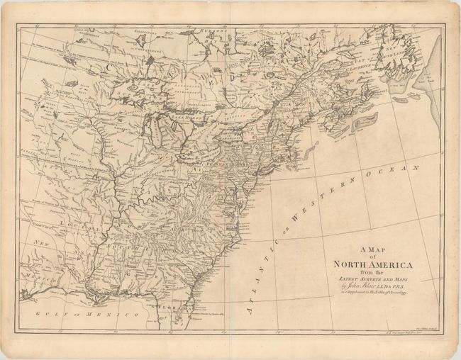
Auction 176, Lot 93
Subject: Colonial Eastern United States & Canada
Blair, Rev. John
A Map of North America from the Latest Surveys and Maps, 1768
Size: 22.6 x 16.5 inches (57.4 x 41.9 cm)
Estimate: $550 - $650
Sold for: $400
Closed on 2/12/2020
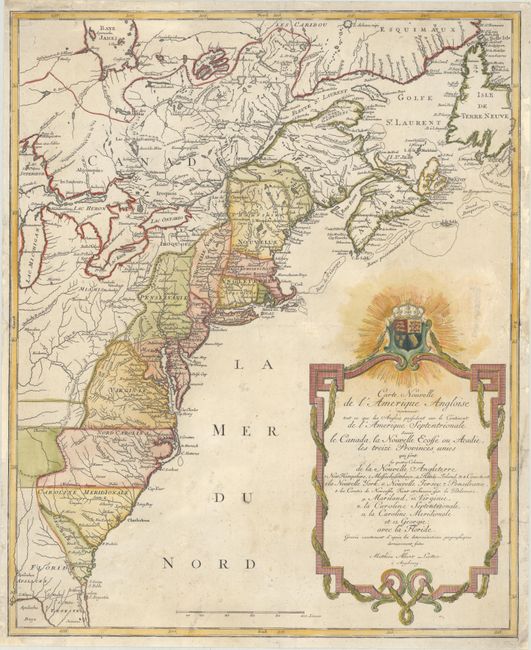
Auction 176, Lot 94
Subject: Colonial Eastern United States & Canada
Lotter, Mathias Albrecht
Carte Nouvelle de l'Amerique Angloise Contenant Tout ce que les Anglois Possedent sur le Continent de l'Amerique Septentrionale Savoir le Canada, la Nouvelle Ecosse ou Acadie, les Treize Provinces Unies..., 1776
Size: 19.5 x 23.8 inches (49.5 x 60.5 cm)
Estimate: $900 - $1,100
Sold for: $650
Closed on 2/12/2020
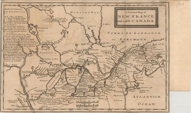
Auction 176, Lot 95
Subject: Colonial Eastern United States & Canada, Great Lakes
Lahontan, Louis Armand, Baron de
A General Map of New France Com. Call'd Canada, 1703
Size: 13.4 x 8.8 inches (34 x 22.4 cm)
Estimate: $1,200 - $1,500
Sold for: $600
Closed on 2/12/2020
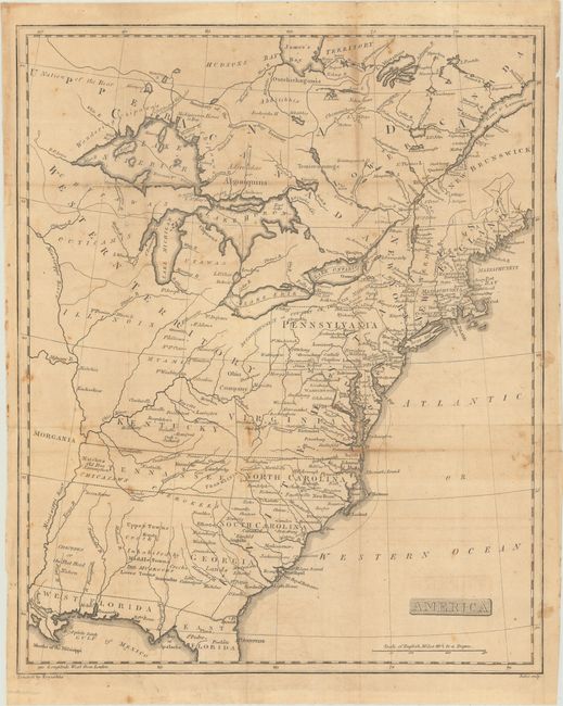
Auction 176, Lot 96
Subject: Eastern United States & Canada, Franklin
America, 1805
Size: 12.9 x 15.9 inches (32.8 x 40.4 cm)
Estimate: $750 - $900
Unique Map Depicting Both Franklinia and Morgania
Sold for: $550
Closed on 2/12/2020
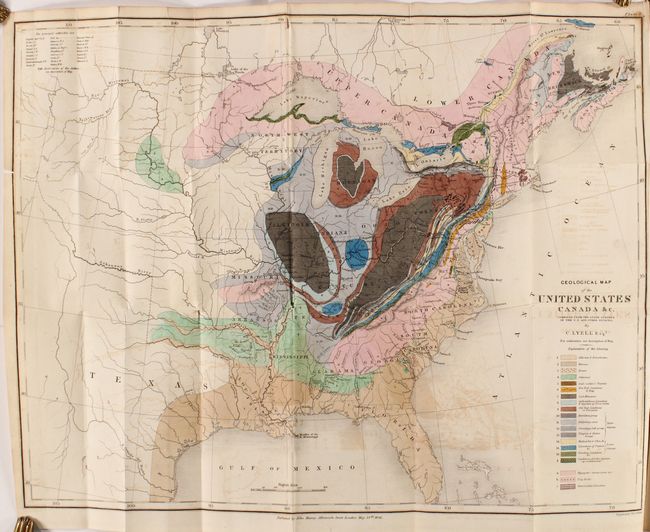
Auction 176, Lot 97
Subject: Eastern United States & Canada, Geology
Lyell, Charles
Geological Map of the United States Canada &c. [with] [2 Volumes] Travels in North America, in the Years 1841-2; with Geological Observations on the United States, Canada, and Nova Scotia, 1845
Size: 19.8 x 15.1 inches (50.3 x 38.4 cm)
Estimate: $600 - $750
First American Edition of Lyell's Important Account & Geological Map
Sold for: $600
Closed on 2/12/2020
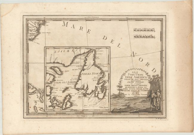
Auction 176, Lot 98
Subject: Eastern Canada & Southeast United States
Cassini, Giovanni Maria
Gli Stati Uniti dell'America Delineati Sulle Ultime Osservazioni - Sesto Foglio che Comprende Parte Della Carolina ed Inoltre l'Isola di Terra Nuova Colle Altre Isole del Golfo di S. Lorenzo, 1797
Size: 18.7 x 13.5 inches (47.5 x 34.3 cm)
Estimate: $375 - $450
Sold for: $150
Closed on 2/12/2020
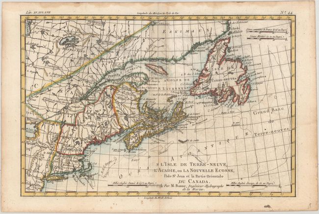
Auction 176, Lot 99
Subject: Colonial Northeastern United States & Canada
Bonne, Rigobert
L'Isle de Terre-Neuve, l'Acadie, ou la Nouvelle Ecosse, l'Isle St Jean et la Partie Orientale du Canada, 1775
Size: 12.6 x 8.3 inches (32 x 21.1 cm)
Estimate: $150 - $180
NO RESERVE
Sold for: $90
Closed on 2/12/2020
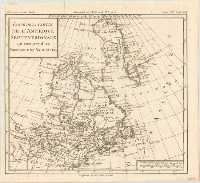
Auction 176, Lot 100
Subject: Colonial Northeastern United States & Canada
Brion de la Tour, Louis
Carte de la Partie de l'Amerique Septentrionale qui Comprend les Possessions Anglaises, 1782
Size: 10 x 8.8 inches (25.4 x 22.4 cm)
Estimate: $110 - $140
Sold for: $80
Closed on 2/12/2020
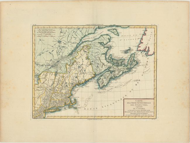
Auction 176, Lot 101
Subject: Northeastern United States & Canada
Tardieu, Pierre Francois
Carte de la Partie Septentrionale des Etats Unis, Comprenant le Canada, la Nouvelle Ecosse, New Hampshire, Massachuset's Bay, Rhode-Island, Connecticut, New-Yorck, Etat de Vermont..., 1797
Size: 16.7 x 12.8 inches (42.4 x 32.5 cm)
Estimate: $190 - $220
Sold for: $120
Closed on 2/12/2020
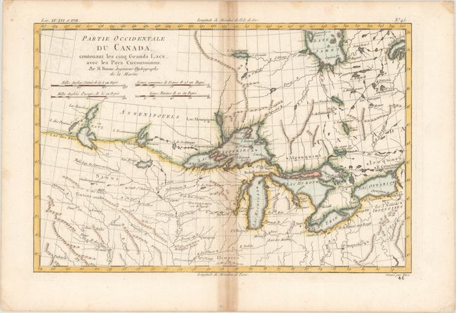
Auction 176, Lot 102
Subject: Colonial Great Lakes
Bonne, Rigobert
Partie Occidentale du Canada, Contenant les Cinq Grands Lacs, avec les Pays Circonvoisins, 1780
Size: 12.4 x 8.1 inches (31.5 x 20.6 cm)
Estimate: $160 - $190
Sold for: $120
Closed on 2/12/2020
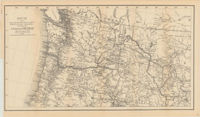
Auction 176, Lot 103
Subject: Northwestern United States, British Columbia
U.S. Government
Route from Fort Ellis Montana to Fort Hope, British Columbia, Travelled by General Sherman July and August 1883, as Shown by Heavy Black Line, 1883
Size: 27.4 x 15.2 inches (69.6 x 38.6 cm)
Estimate: $200 - $250
Sold for: $275
Closed on 2/12/2020
25 lots