Subject: Colonial Eastern United States & Canada, Great Lakes
Period: 1703 (published)
Publication: New Voyages to North America
Color: Black & White
Size:
13.4 x 8.8 inches
34 x 22.4 cm
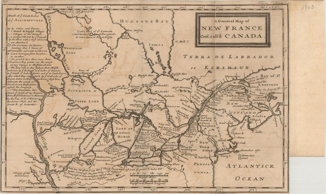
Baron Louis de Lahontan's map of Canada and the Great Lakes became the most widely known general map of New France in the early 18th century. This is the scarce first English edition, engraved by Herman Moll and published in the same year as the French edition. Moll updated the map slightly with the inclusion of Long Island and extended the map further west, thus emphasizing the Longue River. Although the geography is inferior to many contemporary maps and much of it is fanciful, it offers a unique depiction of the region based on the extensive exploration of French fur traders. The canoe routes and outposts are all shown in striking detail, including the important portages connecting Lake Michigan with the Mississippi and the forts built by La Salle. The map is filled with English text notations.
References: McCorkle #703.6; Kershaw #296.
Condition: B
Map has been backed with very fine 18th century linen to repair a long binding tear and was folded and rebound at that time. Narrow margins as issued, with light toning and offsetting. There is a short fold separation at top left that just passes the map border.