Filtered by Category:Canada(Show All Categories)
Showing results for:Auction 170
Catalog Archive
28 lots
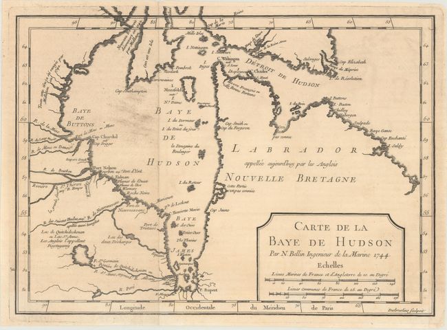
Auction 170, Lot 117
Subject: Eastern Canada, Hudson Bay
Bellin, Jacques Nicolas
Carte de la Baye de Hudson, 1744
Size: 11.5 x 8.4 inches (29.2 x 21.3 cm)
Estimate: $100 - $130
Sold for: $65
Closed on 11/14/2018
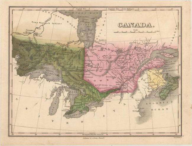
Auction 170, Lot 118
Subject: Eastern Canada
[Lot of 3] Canada [and] Newfoundland Nova Scotia and New Brunswick [and] Nova-Scotia New Brunswick &c., 1824-43
Size: See Description
Estimate: $100 - $130
Sold for: $50
Closed on 11/14/2018
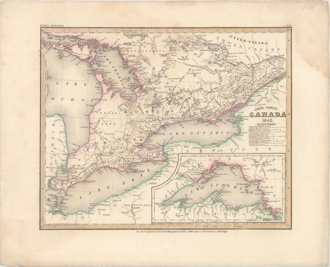
Auction 170, Lot 119
Subject: Eastern Canada, Great Lakes
Hildburghausen Biblio Institut
[Lot of 2] Ober- (Upper-) Canada [and] Neueste Karte von Lower Canada. (Unter-Canada)..., 1844-45
Size: 14.6 x 11.8 inches (37.1 x 30 cm)
Estimate: $100 - $130
Unsold
Closed on 11/14/2018
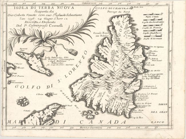
Auction 170, Lot 120
Subject: Newfoundland, Canada
Coronelli, Vincenzo Maria
Isola di Terra Nuova Scoperta da Gio: Cabota Veneto con suo Figliuolo Sebastiano…, 1691
Size: 12.1 x 9.1 inches (30.7 x 23.1 cm)
Estimate: $375 - $450
Sold for: $250
Closed on 11/14/2018
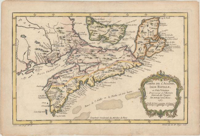
Auction 170, Lot 121
Subject: Nova Scotia, Canada
Bellin, Jacques Nicolas
Carte de l'Acadie, Isle Royale, et Pais Voisins. Pour Servir a l'Histoire Generale des Voyages, 1757
Size: 12.9 x 8.2 inches (32.8 x 20.8 cm)
Estimate: $140 - $170
Sold for: $120
Closed on 11/14/2018
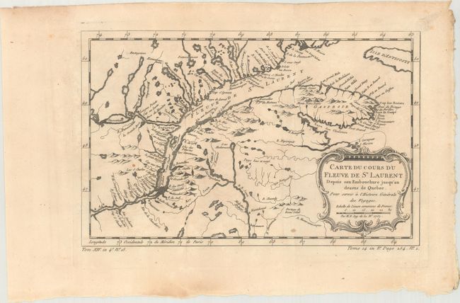
Auction 170, Lot 122
Subject: St. Lawrence River, Canada
Bellin, Jacques Nicolas
[Lot of 2] Carte du Cours du Fleuve de St Laurent... [and] Suite du Cours du Fleuve de St. Laurent Depuis Quebec..., 1757
Size: See Description
Estimate: $140 - $170
Sold for: $75
Closed on 11/14/2018
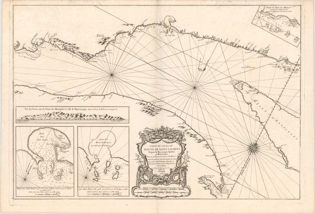
Auction 170, Lot 123
Subject: St. Lawrence River, Canada
Bellin, Jacques Nicolas
Carte du Cours du Fleuve de Saint Laurent Depuis la Mer Jusqu'a Quebec, en Deux Feuilles ... IIe. Feuille, 1761
Size: 33.2 x 22.4 inches (84.3 x 56.9 cm)
Estimate: $400 - $475
Sold for: $275
Closed on 11/14/2018
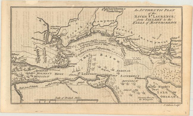
Auction 170, Lot 124
Subject: Quebec City, Canada
Gibson, John
An Authentic Plan of the River St. Laurence, from Sillery to the Falls of Montmorency, 1759
Size: 7.3 x 4.1 inches (18.5 x 10.4 cm)
Estimate: $120 - $150
Sold for: $65
Closed on 11/14/2018
Auction 170, Lot 125
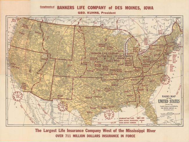
Subject: United States & Canada
Cram, George F. & Company
[Lot of 3] Radio Map of the United States [and] Cram's Detailed Radio Map of the United States & Canada [and] Cram's Detailed Radio Map of the United States & Canada, 1924
Size: See Description
Estimate: $220 - $250
Sold for: $150
Closed on 11/14/2018
Auction 170, Lot 126
Subject: Colonial Eastern United States & Canada
Mortier, Pierre
Carte Nouvelle de l'Amerique Angloise Contenant la Virginie, Mary-Land, Caroline, Pensylvania Nouvelle Iorck. N: Iarsey N: France, et les Terres Nouvellement Decouerte..., 1700
Size: 35.4 x 23.4 inches (89.9 x 59.4 cm)
Estimate: $1,900 - $2,200
A Map Showing Fascinating Geographic Misconceptions
Unsold
Closed on 11/14/2018
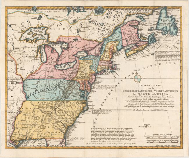
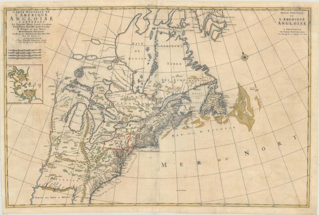
Auction 170, Lot 127
Subject: Colonial Eastern United States & Canada
Tirion, Isaac
Nieuwe Kaart van de Grootbrittannische Volkplantingen in Noord America..., 1755
Size: 17.9 x 14.4 inches (45.5 x 36.6 cm)
Estimate: $600 - $750
Sold for: $550
Closed on 11/14/2018
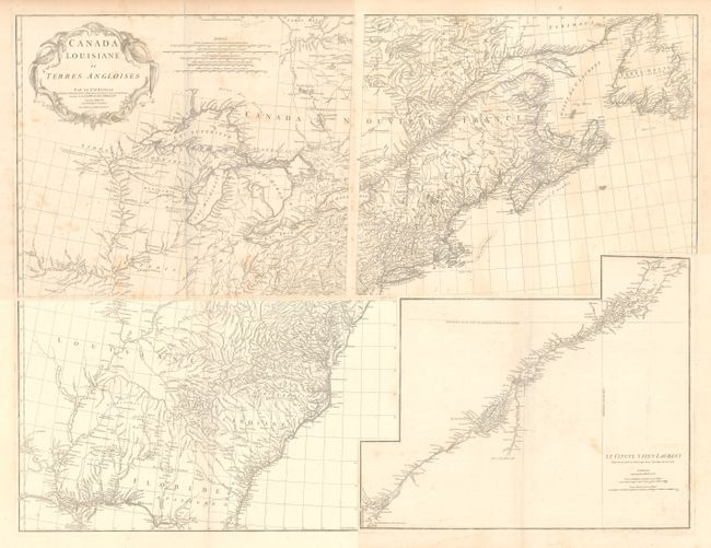
Auction 170, Lot 128
Subject: Colonial Eastern United States & Canada
Anville, Jean Baptiste Bourguignon d'
[On 4 Sheets] Canada Louisiane et Terres Angloises, 1755
Size: 22 x 18.8 inches (55.9 x 47.8 cm)
Estimate: $1,400 - $1,700
D'Anville's Spectacular Map of Eastern Seaboard
Unsold
Closed on 11/14/2018
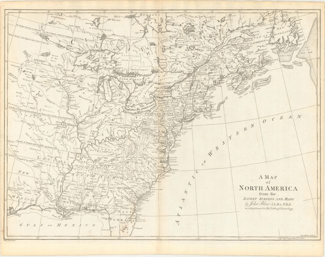
Auction 170, Lot 129
Subject: Colonial Eastern United States & Canada
Blair, Rev. John
A Map of North America from the Latest Surveys and Maps, 1768
Size: 22.8 x 16.6 inches (57.9 x 42.2 cm)
Estimate: $550 - $700
Sold for: $400
Closed on 11/14/2018
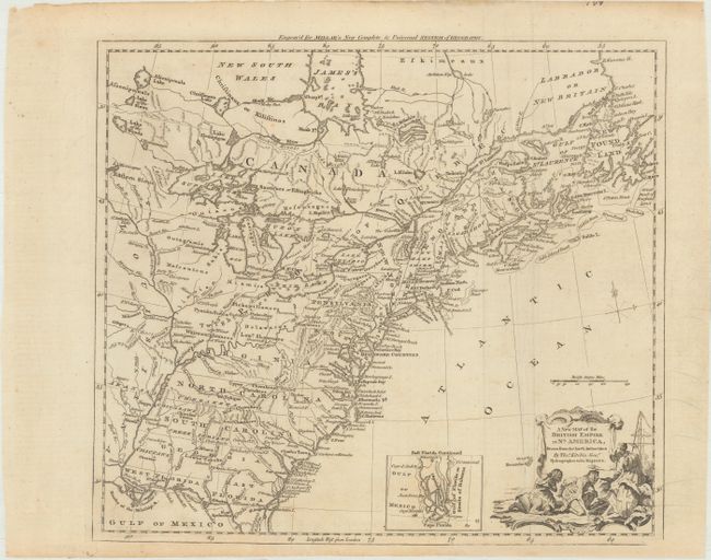
Auction 170, Lot 130
Subject: Colonial Eastern United States & Canada
Kitchin, Thomas
A New Map of the British Empire in Nth. America, Drawn from the Latest Authorities, 1782
Size: 15 x 13.3 inches (38.1 x 33.8 cm)
Estimate: $400 - $475
Sold for: $250
Closed on 11/14/2018
Auction 170, Lot 131
Subject: Colonial Eastern United States & Canada
Sotzmann, Daniel Friedrich
Die Vereinigten Staaten von Nord-America. Nach der von Wm. Faden 1783 herausgegebenen Charte / Les Etats Unis de l'Amerique Septentrionale d'Apres la Carte de Wm. Faden Publiee a Londres en 1783..., 1785
Size: 10 x 7.6 inches (25.4 x 19.3 cm)
Estimate: $600 - $800
Rare, Multi-Lingual Reduced Version of Faden's Map of 1783
Sold for: $550
Closed on 11/14/2018
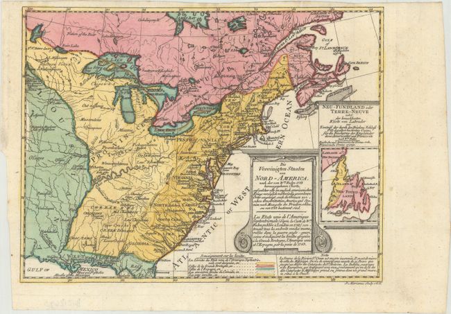
Auction 170, Lot 132
Subject: Eastern United States & Canada
Tardieu, Pierre Francois
Carte Generale des Etats Unis de l'Amerique Septentrionale, Renfermantaussi Quelques Provinces Angloises Adjacentes, 1797
Size: 16.8 x 12.7 inches (42.7 x 32.3 cm)
Estimate: $240 - $300
Sold for: $180
Closed on 11/14/2018
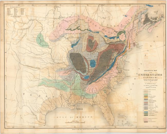
Auction 170, Lot 133
Subject: Eastern United States & Canada, Geology
Lyell, Charles
Geological Map of the United States Canada &c. [with] [2 Volumes] Travels in North America, in the Years 1841-2; with Geological Observations on the United States, Canada, and Nova Scotia, 1845
Size: 19.8 x 15.3 inches (50.3 x 38.9 cm)
Estimate: $600 - $750
First American Edition of Lyell's Important Account & Geological Map
Sold for: $450
Closed on 11/14/2018
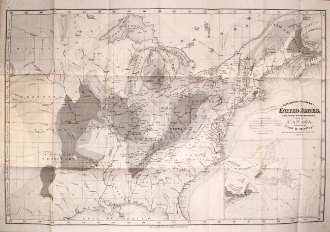
Auction 170, Lot 134
Subject: Eastern United States & Canada, Geology
Geological Chart of the United States, East of the Rocky Mountains. And of Canada, 1876
Size: 23.7 x 15.6 inches (60.2 x 39.6 cm)
Estimate: $250 - $325
Sold for: $180
Closed on 11/14/2018
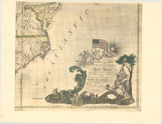
Auction 170, Lot 135
Subject: Eastern United States & Canada
[Facsimile - On 4 Sheets] A New and Correct Map of the United States of North America Layd Down from the Latest Observations and Best Authorities Agreeable to the Peace of 1783..., 1963
Size: 25.4 x 21.7 inches (64.5 x 55.1 cm)
Estimate: $550 - $700
Facsimile of the First Large-Scale Map Printed in North America
Sold for: $275
Closed on 11/14/2018
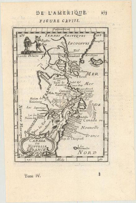
Auction 170, Lot 136
Subject: Colonial Northeastern United States & Canada
Mallet, Alain Manesson
Canada ou Nouvelle France, 1683
Size: 3.9 x 5.6 inches (9.9 x 14.2 cm)
Estimate: $220 - $250
Sold for: $100
Closed on 11/14/2018
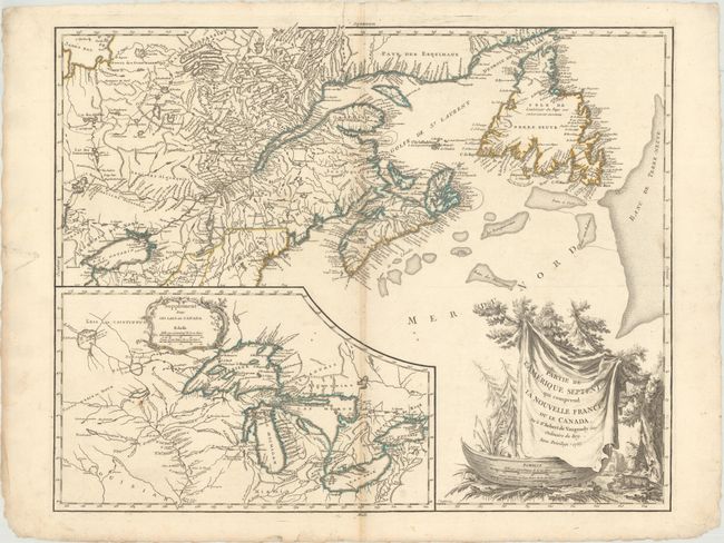
Auction 170, Lot 137
Subject: Colonial Northeastern United States & Canada, Great Lakes
Robert de Vaugondy, Didier
Partie de l'Amerique Septent? qui Comprend la Nouvelle France ou le Canada, 1755
Size: 23.9 x 19 inches (60.7 x 48.3 cm)
Estimate: $550 - $700
Unsold
Closed on 11/14/2018
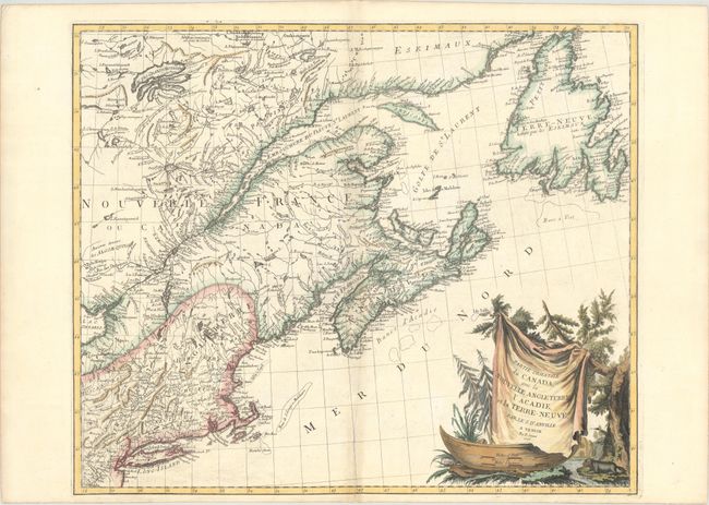
Auction 170, Lot 138
Subject: Colonial Northeastern United States & Canada
D'Anville/Santini
Partie Orientale du Canada, avec la Nouvelle Angleterre, l'Acadie, et la Terre-Neuve, 1776
Size: 22.9 x 19.1 inches (58.2 x 48.5 cm)
Estimate: $600 - $750
Unsold
Closed on 11/14/2018
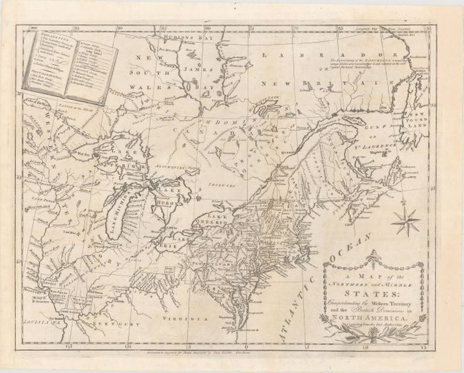
Auction 170, Lot 139
Subject: Northeastern United States & Canada
Doolittle, Amos
A Map of the Northern and Middle States; Comprehending the Western Territory and the British Dominions in North America. Compiled from the Best Authorities, 1789
Size: 16.1 x 12.5 inches (40.9 x 31.8 cm)
Estimate: $450 - $550
Sold for: $325
Closed on 11/14/2018
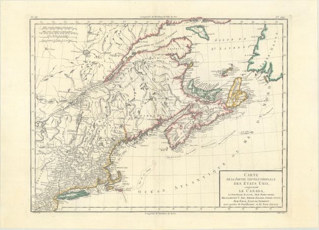
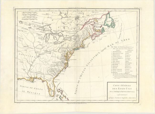
Auction 170, Lot 140
Subject: Northeastern United States & Canada
Tardieu, Pierre Francois
Carte de la Partie Septentrionale des Etats Unis, Comprenant le Canada, la Nouvelle Ecosse, New Hampshire, Massachuset's Bay, Rhode-Island, Connecticut, New-Yorck, Etat de Vermont..., 1797
Size: 16.6 x 12.7 inches (42.2 x 32.3 cm)
Estimate: $240 - $300
Unsold
Closed on 11/14/2018
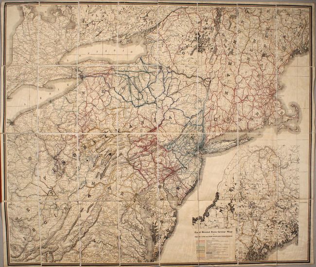
Auction 170, Lot 141
Subject: Northeastern United States & Canada
East Bound Rate Group Map of Trunk Line and New England Territories, 1912
Size: 40.9 x 34.9 inches (103.9 x 88.6 cm)
Estimate: $160 - $200
Sold for: $220
Closed on 11/14/2018
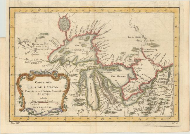
Auction 170, Lot 142
Subject: Colonial Central United States & Canada, Great Lakes
Bellin, Jacques Nicolas
Carte des Lacs du Canada pour Servir a l'Histoire Generale des Voyages, 1757
Size: 11.6 x 7.8 inches (29.5 x 19.8 cm)
Estimate: $400 - $475
Sold for: $325
Closed on 11/14/2018
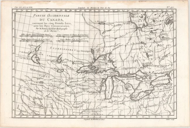
Auction 170, Lot 143
Subject: Colonial Great Lakes
Bonne, Rigobert
Partie Occidentale du Canada, Contenant les Cinq Grands Lacs, avec les Pays Circonvoisins, 1775
Size: 12.6 x 8.4 inches (32 x 21.3 cm)
Estimate: $200 - $230
Sold for: $100
Closed on 11/14/2018
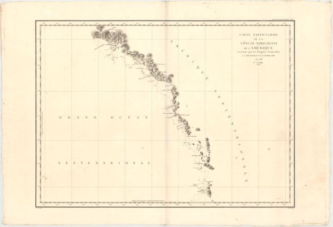
Auction 170, Lot 144
Subject: Western United States & Canada, Alaska
La Perouse, Comte Jean F. Galoup, de
[Lot of 3] Carte Particuliere de la Cote du Nord-Ouest de l'Amerique Reconnue par les Fregates Francaises la Boussole et l'Astrolabe en 1786. 1e. Feuille [and] 2e Feuille [and] 3e Feuille, 1797
Size: 26.8 x 19.4 inches (68.1 x 49.3 cm)
Estimate: $400 - $475
Sold for: $230
Closed on 11/14/2018
28 lots