Filtered by Category:Canada(Show All Categories)
Showing results for:Auction 162
Catalog Archive
29 lots
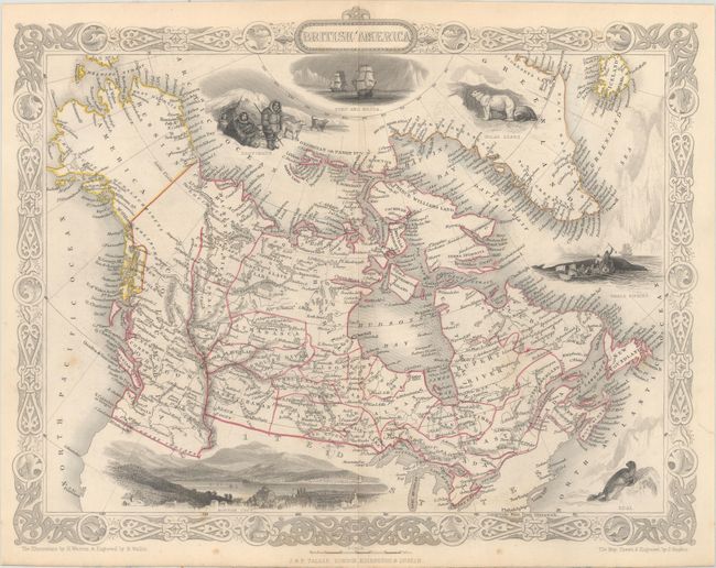
Auction 162, Lot 103
Subject: Canada
Tallis, John
[Lot of 3] British America [and] West Canada [and] East Canada, and New Brunswick, 1850
Size: 12.9 x 10.2 inches (32.8 x 25.9 cm)
Estimate: $240 - $300
Sold for: $150
Closed on 4/26/2017
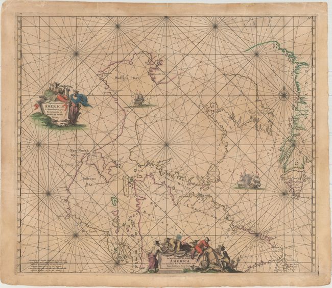
Auction 162, Lot 104
Subject: Northern Canada & Greenland
Wit, Frederick de
Septemtrionaliora Americae a Groenlandia, per Freta Davidis et Hudson, ad Terram Novam / De Noordelyckste Zee Kusten van America van Groenland door de Straet Davis ende Straet Hudson tot Terra Neuf, 1680
Size: 22.1 x 19 inches (56.1 x 48.3 cm)
Estimate: $700 - $850
Unsold
Closed on 4/26/2017
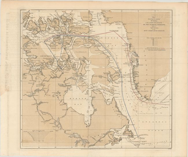
Auction 162, Lot 105
Subject: Northern Canada & Greenland
Findlay, Alexander
Chart Illustrating the Remarks of Mr. Findlay, on the Probable Course Pursued by Sir John Franklin's Expedition; and of Captn. Irminger, on the Arctic Current Around Greenland, 1856
Size: 13.1 x 12.1 inches (33.3 x 30.7 cm)
Estimate: $200 - $250
Sold for: $150
Closed on 4/26/2017
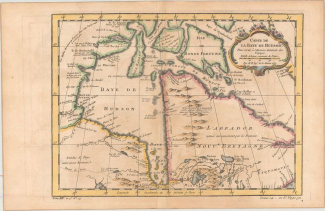
Auction 162, Lot 106
Subject: Eastern Canada
Bellin, Jacques Nicolas
[Lot of 2] Carte de la Baye de Hudson, pour Servir a l'Histoire Generale des Voyages [and] Carte de l'Acadie, Isle Royale, et Pais Voisins. Pour Servir a l'Histoire Generale des Voyages, 1757
Size: See Description
Estimate: $180 - $210
NO RESERVE
Sold for: $85
Closed on 4/26/2017
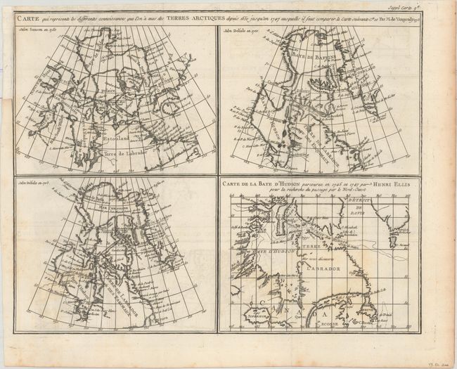
Auction 162, Lot 107
Subject: Eastern Canada
Robert de Vaugondy, Didier
Carte qui Represente les Differentes Connoissances que l'on a eues des Terres Arctiques Depuis 1650 Jusqu'en 1747..., 1773
Size: 15.1 x 12 inches (38.4 x 30.5 cm)
Estimate: $70 - $90
NO RESERVE
Sold for: $41
Closed on 4/26/2017
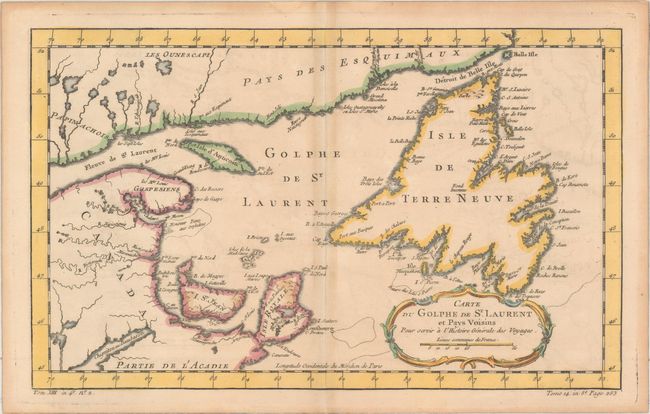
Auction 162, Lot 108
Subject: Eastern Canada, St. Lawrence River
Bellin, Jacques Nicolas
[Lot of 3] Carte du Golphe de St. Laurent et Pays Voisins... [and] Carte du Cours de Fleuve de St. Laurent Depuis son Embouchure Jusqu'au Dessus de Quebec... [and] Suite du Cours du Fleuve de St. Laurent, Depuis Quebec Jusqu au Lac Ontario..., 1780
Size: See Description
Estimate: $240 - $300
Sold for: $120
Closed on 4/26/2017
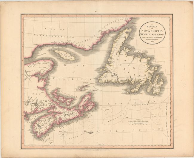
Auction 162, Lot 109
Subject: Eastern Canada
Cary, John
A New Map of Nova Scotia, Newfoundland &c. from the Latest Authorities, 1807
Size: 20.3 x 18 inches (51.6 x 45.7 cm)
Estimate: $160 - $190
NO RESERVE
Sold for: $75
Closed on 4/26/2017
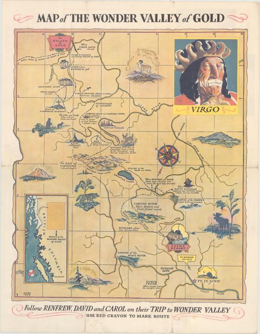
Auction 162, Lot 110
Subject: British Columbia, Canada
Map of the Wonder Valley of Gold, 1936
Size: 15.8 x 18.4 inches (40.1 x 46.7 cm)
Estimate: $140 - $170
Sold for: $75
Closed on 4/26/2017
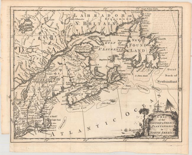
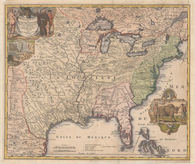
Auction 162, Lot 111
Subject: Colonial United States & Canada
Anon.
A Map of the British & French Plantations in North America, 1755
Size: 10.4 x 8.3 inches (26.4 x 21.1 cm)
Estimate: $220 - $250
Sold for: $130
Closed on 4/26/2017
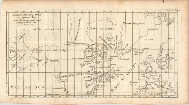
Auction 162, Lot 112
Subject: Colonial United States, Canada & Arctic
Robert de Vaugondy, Didier
Partie de la Carte du Capitaine Cluny Auteur d'un Ouvrage Anglois Intitule American Traveller Publie a Londres en 1769, 1769
Size: 16.2 x 8.5 inches (41.1 x 21.6 cm)
Estimate: $120 - $150
Sold for: $45
Closed on 4/26/2017
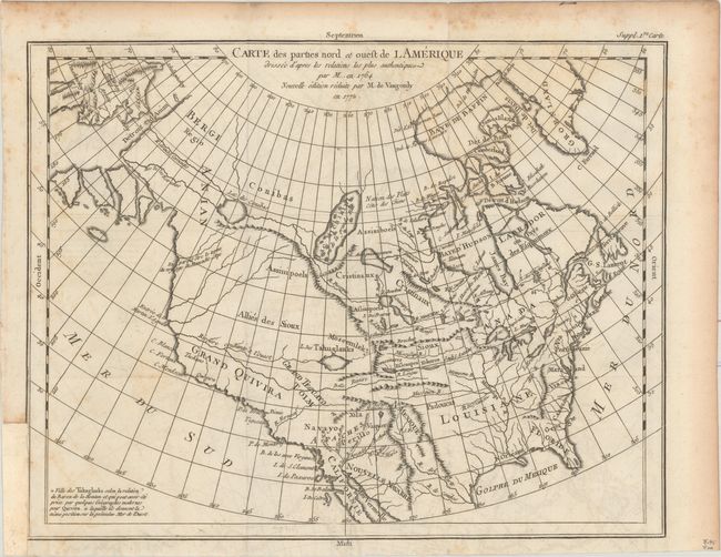
Auction 162, Lot 113
Subject: Colonial United States & Canada
Robert de Vaugondy, Didier
Carte des Parties Nord et Ouest de l Amerique Dressee d'Apres les Relations les Plus Authentiques par M... en 1764..., 1772
Size: 15.2 x 11.8 inches (38.6 x 30 cm)
Estimate: $160 - $200
Sold for: $80
Closed on 4/26/2017
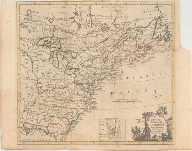
Auction 162, Lot 114
Subject: Colonial Eastern United States & Canada
Kitchin, Thomas
British Dominions in America, Drawn from the Latest and Best Authorities [with related text], 1782
Size: 14.8 x 13.4 inches (37.6 x 34 cm)
Estimate: $600 - $750
Unsold
Closed on 4/26/2017
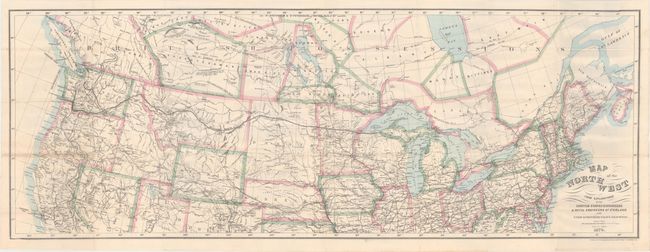
Auction 162, Lot 115
Subject: United States & Canada
Bien, Julius
Map of the Northwest from Explorations by the United States Engineers & Royal Engineers of England and Union & Northern Pacific R.R. Surveys [in] The Seat of Empire, 1870
Size: 41.1 x 15.1 inches (104.4 x 38.4 cm)
Estimate: $200 - $250
Sold for: $160
Closed on 4/26/2017
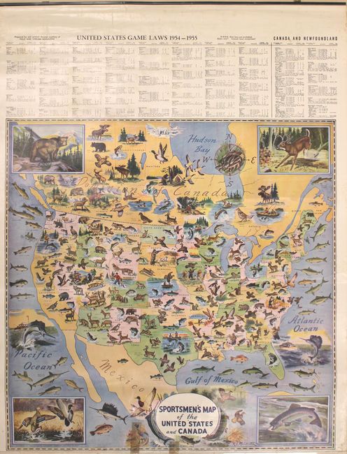
Auction 162, Lot 116
Subject: United States & Canada
Geographical Publishing Co.
[4 Sheet Wall Map] Sportsmen's Map of the United States and Canada, 1954
Size: 26 x 26.1 inches (66 x 66.3 cm)
Estimate: $150 - $180
Sold for: $250
Closed on 4/26/2017
Auction 162, Lot 117
Subject: Colonial Eastern United States & Canada
Mortier, Pierre
Carte Nouvelle de l'Amerique Angloise Contenant la Virginie, Mary-Land, Caroline, Pensylvania Nouvelle Iorck, N: Iarsey N: France, et les Terres Nouvellement Decouerte..., 1700
Size: 35.9 x 23.4 inches (91.2 x 59.4 cm)
Estimate: $2,000 - $2,300
A Map Showing Fascinating Geographic Misconceptions
Sold for: $1,500
Closed on 4/26/2017
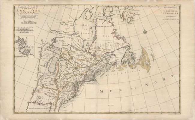
Auction 162, Lot 118
Subject: Colonial Eastern United States & Canada
Homann, Johann Baptist
Amplissimae Regionis Mississipi seu Provinciae Ludovicianae..., 1720
Size: 22.8 x 19.1 inches (57.9 x 48.5 cm)
Estimate: $2,000 - $2,300
Striking Map of Colonial America with Buffalo Vignette
Sold for: $1,300
Closed on 4/26/2017
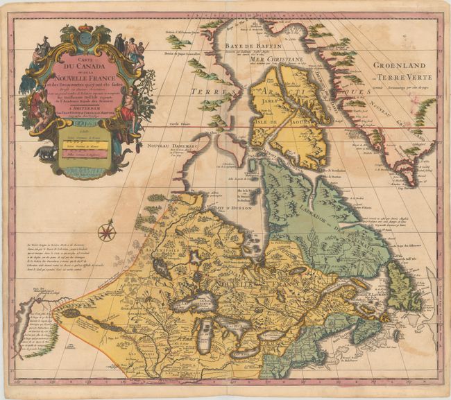
Auction 162, Lot 119
Subject: Colonial Eastern United States & Canada, Great Lakes
Delisle/Covens & Mortier
Carte du Canada ou de la Nouvelle France et des Decouvertes qui y ont ete Faites Dressee sur Plusieurs Observations et sur un Grand Nombre de Relations Imprimees ou Manuscrites, 1730
Size: 22.3 x 19.3 inches (56.6 x 49 cm)
Estimate: $900 - $1,100
One of the Most Influential Maps of Canada, the Great Lakes and Upper Midwest
Sold for: $650
Closed on 4/26/2017
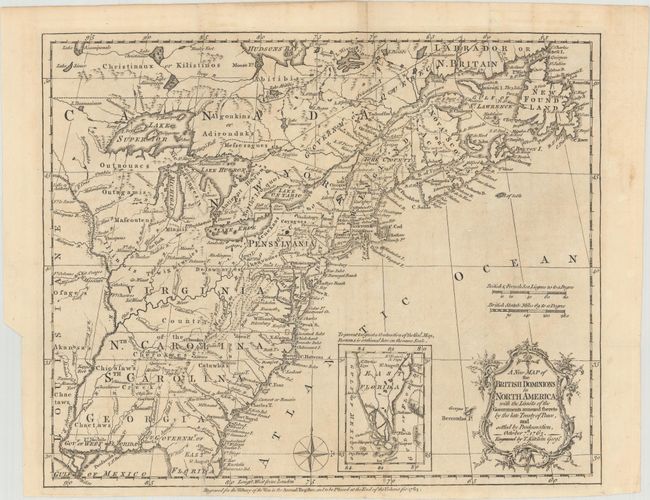
Auction 162, Lot 120
Subject: Colonial Eastern United States & Canada
Kitchin, Thomas
A New Map of the British Dominions in North America; with the Limits of the Governments Annexed Thereto by the Late Treaty of Peace, and Settled by Proclamation, October 7th, 1763, 1763
Size: 11.8 x 9.5 inches (30 x 24.1 cm)
Estimate: $350 - $425
Sold for: $250
Closed on 4/26/2017
Auction 162, Lot 121
Subject: Colonial Eastern United States & Canada
Bonne/Lattre
[On 2 Sheets] Partie de l'Amerique Septentrionale, qui Comprend le Canada, la Louisiane, le Labrador, le Groenland, la Nouvelle Angleterre, la Floride &c. Projettee et Assujettie aux Observations, 1771
Size: 17.1 x 11.8 inches (43.4 x 30 cm)
Estimate: $550 - $700
Sold for: $265
Closed on 4/26/2017
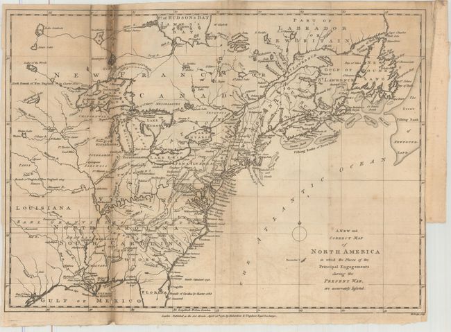
Auction 162, Lot 122
Subject: Colonial Eastern United States & Canada
Lodge, John
A New and Correct Map of North America in Which the Places of the Principal Engagements During the Present War, Are Accurately Inserted, 1780
Size: 15.1 x 10.9 inches (38.4 x 27.7 cm)
Estimate: $500 - $650
Unsold
Closed on 4/26/2017
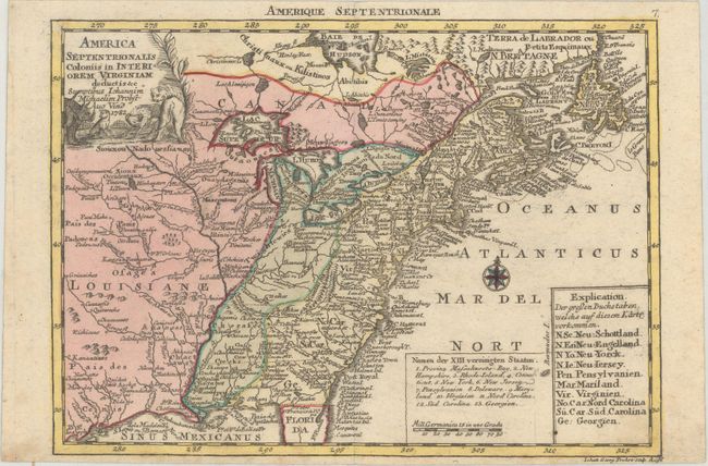
Auction 162, Lot 123
Subject: Colonial Eastern United States & Canada
Probst, Johann Michael
America Septentrionalis Coloniis in Interiorem Virginiam Deductis &c., 1782
Size: 9.4 x 6.8 inches (23.9 x 17.3 cm)
Estimate: $500 - $650
Sold for: $275
Closed on 4/26/2017
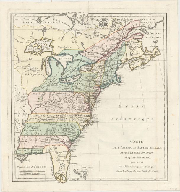
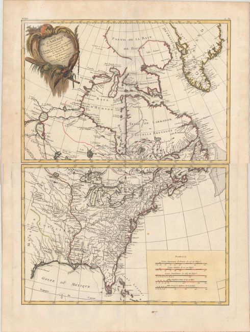
Auction 162, Lot 124
Subject: Colonial Eastern United States & Canada
Carte de l'Amerique Septentrionale, Depuis la Baye d'Hudson Jusqu'au Mississipi: pour Servir aux Essais Historiques et Politiques..., 1782
Size: 14.9 x 16.4 inches (37.8 x 41.7 cm)
Estimate: $500 - $650
Unsold
Closed on 4/26/2017
Auction 162, Lot 125
Subject: Eastern United States & Canada
SDUK Society for the Diffusion of Useful Knowledge
[Lot of 15 - United States & Canada], 1832-34
Size: See Description
Estimate: $800 - $950
Sold for: $400
Closed on 4/26/2017
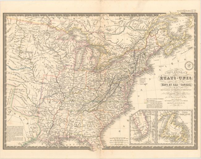
Auction 162, Lot 126
Subject: Eastern United States & Canada
Brue, Adrien Hubert
Carte Generale des Etats-Unis, des Haut et Bas-Canada, de la Nouvle. Ecosse, du Nouvau. Brunswick, de Terre-Neuve, &a. Seconde Edition, 1838
Size: 20.3 x 14.8 inches (51.6 x 37.6 cm)
Estimate: $180 - $220
Sold for: $120
Closed on 4/26/2017
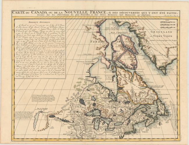
Auction 162, Lot 127
Subject: Colonial Northeastern United States & Canada
Chatelain, Henry Abraham
Carte du Canada ou de la Nouvelle France, & des Decouvertes qui y ont ete Faites, Dressee sur les Observations les Plus Nouvelles, & sur Divers Memoires tant Manuscrits qu' Imprimez, 1719
Size: 20.4 x 15.9 inches (51.8 x 40.4 cm)
Estimate: $600 - $750
Unsold
Closed on 4/26/2017
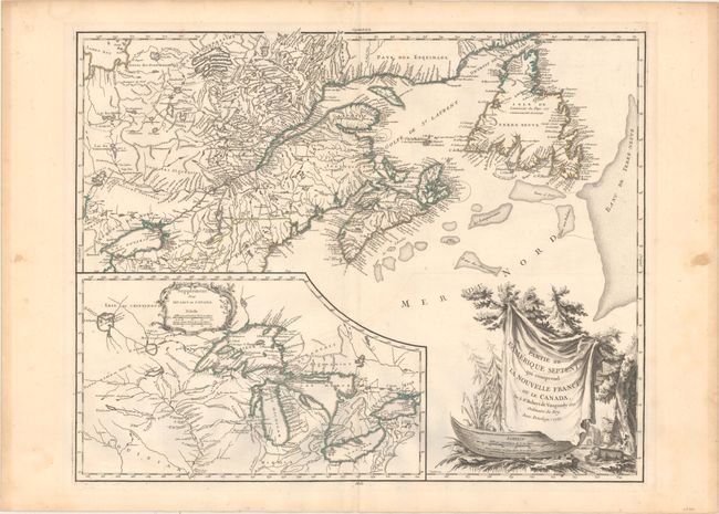
Auction 162, Lot 128
Subject: Colonial Northeastern United States & Canada, Great Lakes
Robert de Vaugondy, Didier
Partie de l'Amerique Septent? qui Comprend la Nouvelle France ou le Canada, 1755
Size: 23.8 x 19 inches (60.5 x 48.3 cm)
Estimate: $650 - $800
Uncommon First State
Unsold
Closed on 4/26/2017
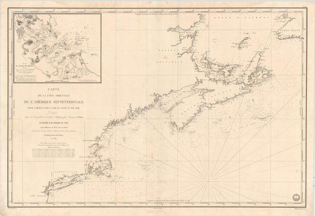
Auction 162, Lot 129
Subject: Northeastern United States & Canada
Depot de la Marine
Carte de la Cote Orientale de l'Amerique Septentrionale Partie Comprise Entre la Baie de Gaspee et New York..., 1834
Size: 34.3 x 23 inches (87.1 x 58.4 cm)
Estimate: $475 - $600
Unsold
Closed on 4/26/2017
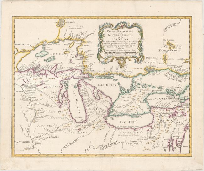
Auction 162, Lot 130
Subject: Colonial Great Lakes
Bellin/Homann Heirs
Partie Occidentale de la Nouvelle France ou du Canada par Mr. Bellin..., 1755
Size: 21.5 x 17 inches (54.6 x 43.2 cm)
Estimate: $1,800 - $2,100
Influential Map of the Great Lakes
Sold for: $975
Closed on 4/26/2017
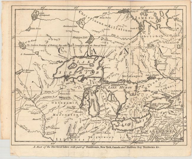
Auction 162, Lot 131
Subject: Colonial Great Lakes
A Map of the Five Great Lakes with Part of Pensilvania, New York, Canada and Hudsons Bay Territories &c., 1755
Size: 10.4 x 8.3 inches (26.4 x 21.1 cm)
Estimate: $275 - $350
Sold for: $240
Closed on 4/26/2017
29 lots