Filtered by Category:Canada(Show All Categories)
Showing results for:Auction 142
Catalog Archive
27 lots
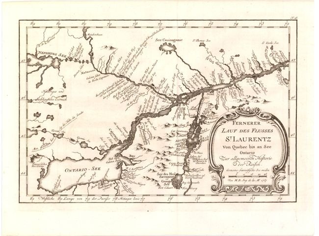
Auction 142, Lot 119
Subject: Eastern Canada
Bellin, Jacques Nicolas
[Lot of 2] Karte von dem Laufe des Flusses St. Laurenz von Seiner Mundung an bis uber Quebec... [and] Fernerer Lauf des Flusses St. Laurentz von Quebec bis an See Ontario..., 1757
Size: 11.3 x 7.4 inches (28.7 x 18.8 cm)
Estimate: $250 - $325
Sold for: $150
Closed on 11/28/2012
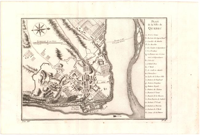
Auction 142, Lot 120
Subject: Quebec, Canada
Bellin, Jacques Nicolas
Plan de la Ville de Quebec, 1757
Size: 11.2 x 7.8 inches (28.4 x 19.8 cm)
Estimate: $160 - $200
Sold for: $100
Closed on 11/28/2012
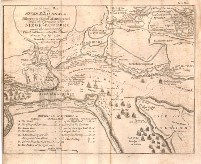
Auction 142, Lot 121
Subject: Quebec, Canada
Royal Magazine
An Authentic Plan of the River St. Laurence, Sillery to the Fall of Montmerenci. With the Operations of the Siege of Quebec, under the Command of Vice-Adml. Saunders & Majr. Genl. Wolfe..., 1759
Size: 9.4 x 7.3 inches (23.9 x 18.5 cm)
Estimate: $400 - $600
Sold for: $150
Closed on 11/28/2012
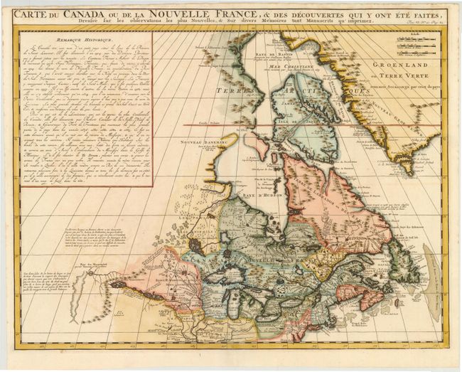
Auction 142, Lot 122
Subject: Colonial United States and Canada, Great Lakes
Chatelain, Henry Abraham
Carte du Canada ou de la Nouvelle France, & des Decouvertes qui y Ont Ete Faites, Dressee sur les Observations les Plus Nouvelles, & sur Divers Memoires tant Manuscrits qu'Imprimez, 1719
Size: 20.5 x 16 inches (52.1 x 40.6 cm)
Estimate: $800 - $1,000
Sold for: $550
Closed on 11/28/2012
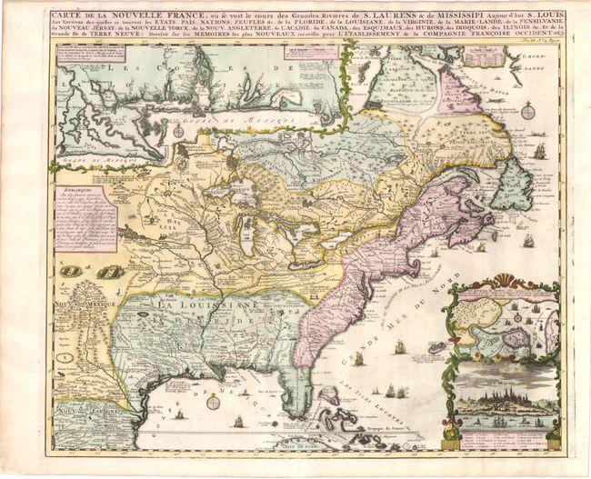
Auction 142, Lot 123
Subject: Colonial United States and Canada
Chatelain, Henry Abraham
Carte de la Nouvelle France, ou se voit le cours des Grandes Rivieres de S. Laurens & de Mississipi Aujour d'hui S. Louis, aux Environs des-quelles se trouvent les Etats, Pais, Nations, Peuples &c., 1719
Size: 19.3 x 16.5 inches (49 x 41.9 cm)
Estimate: $2,000 - $2,400
Sold for: $1,500
Closed on 11/28/2012
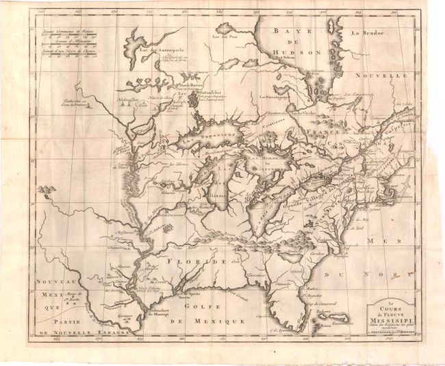
Auction 142, Lot 124
Subject: Colonial United States and Canada, Great Lakes
Bernard, Jean Frederic
Le Cours du Fleuve Missisipi Selon les Relations les Plus Modernes, 1737
Size: 17.2 x 14.6 inches (43.7 x 37.1 cm)
Estimate: $2,000 - $2,300
Sold for: $1,500
Closed on 11/28/2012
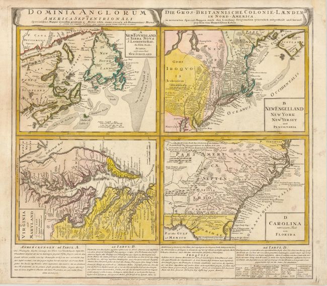
Auction 142, Lot 125
Subject: Colonial United States and Canada
Homann Heirs
Dominia Anglorum in America Septentrionali, 1740
Size: 21.5 x 19.8 inches (54.6 x 50.3 cm)
Estimate: $550 - $700
Sold for: $200
Closed on 11/28/2012
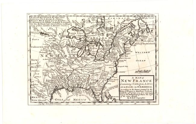
Auction 142, Lot 126
Subject: Colonial United States and Canada
Moll, Herman
A Map of New France Containing Canada, Louisiana &c. in Nth. America..., 1745
Size: 10.2 x 7.2 inches (25.9 x 18.3 cm)
Estimate: $550 - $650
Sold for: $400
Closed on 11/28/2012
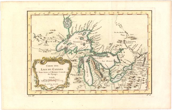
Auction 142, Lot 127
Subject: Colonial United States and Canada, Great Lakes
Bellin, Jacques Nicolas
Carte des Lacs du Canada pour Servir a l'Histoire Generale des Voyages, 1757
Size: 11.5 x 7.7 inches (29.2 x 19.6 cm)
Estimate: $450 - $550
Sold for: $450
Closed on 11/28/2012
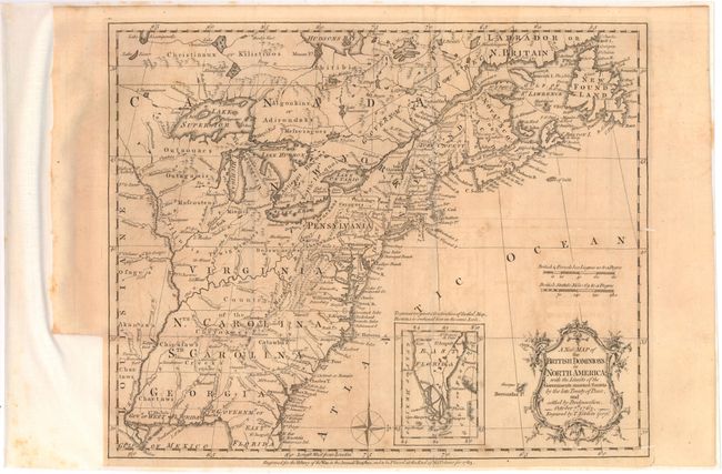
Auction 142, Lot 128
Subject: Colonial United States and Canada
Kitchin, Thomas
A New Map of the British Dominions in North America; with the Limits of the Governments Annexed thereto by the Late Treaty of Peace, and Settled by Proclamation, October 7th, 1763, 1763
Size: 12 x 9.5 inches (30.5 x 24.1 cm)
Estimate: $450 - $550
Sold for: $150
Closed on 11/28/2012
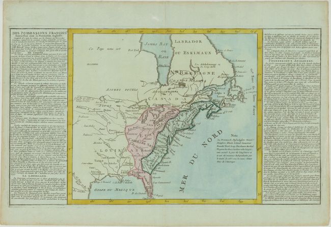
Auction 142, Lot 129
Subject: Colonial United States & Canada
Clouet, Jean Baptiste Louis
[Des Possessions Francoises Aujourd'hui sous la Domination Angloises...], 1767
Size: 21.8 x 12.4 inches (55.4 x 31.5 cm)
Estimate: $275 - $350
Sold for: $220
Closed on 11/28/2012
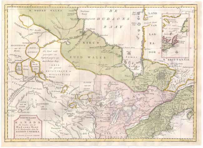
Auction 142, Lot 130
Subject: Colonial United States & Canada
Tirion, Isaac
Nieuwe Kaart van Kanada, de Landen aan de Hudsons-Baay en de Noordwestelyke deelen van Noord-Amerika, 1769
Size: 16.8 x 12 inches (42.7 x 30.5 cm)
Estimate: $300 - $375
Sold for: $220
Closed on 11/28/2012
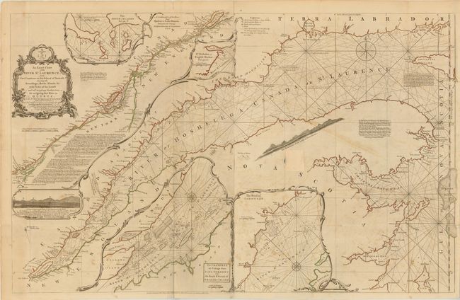
Auction 142, Lot 131
Subject: Colonial United States & Canada, St. Lawrence River
Jefferys/Sayer & Bennett
An Exact Chart of the River St. Laurence, from Fort Frontenac to the Island of Anticosti Shewing the Soundings, Rocks, Shoals, &c. with Views of the Lands and All Necessary Instructions for Navigating that River to Quebec, 1775
Size: 37.5 x 23.5 inches (95.3 x 59.7 cm)
Estimate: $700 - $850
Sold for: $375
Closed on 11/28/2012
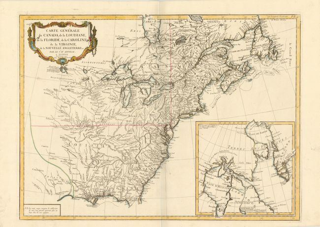
Auction 142, Lot 132
Subject: Colonial United States and Canada
D'Anville/Santini
Carte Generale du Canada, de la Louisiane, de la Floride, de la Caroline, de la Virginie, de la Nouvelle Angleterre etc. par le Sr. d'Anville, 1776
Size: 25.8 x 18.8 inches (65.5 x 47.8 cm)
Estimate: $800 - $950
Sold for: $400
Closed on 11/28/2012
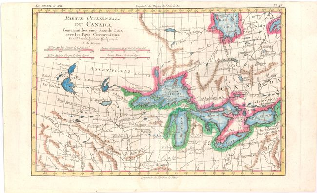
Auction 142, Lot 133
Subject: Colonial United States & Canada
Bonne, Rigobert
Partie Occidentale du Canada, Contenant les Cinq Grands Lacs, avec les Pays Circonvoisins, 1780
Size: 12.5 x 8.3 inches (31.8 x 21.1 cm)
Estimate: $240 - $275
Sold for: $180
Closed on 11/28/2012
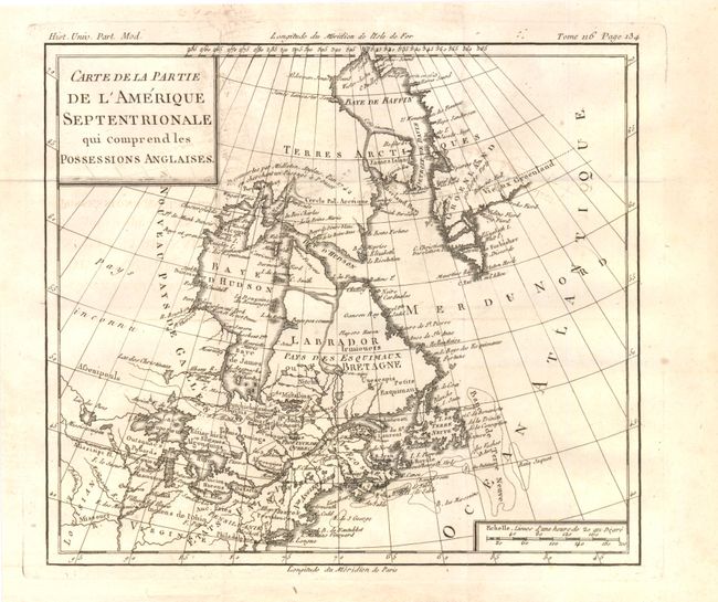
Auction 142, Lot 134
Subject: Colonial United States & Canada
Brion de la Tour, Louis
Carte de la Partie de l'Amerique Septentrionale qui Comprend les Possessions Anglaises, 1782
Size: 10 x 8.8 inches (25.4 x 22.4 cm)
Estimate: $150 - $200
Sold for: $75
Closed on 11/28/2012
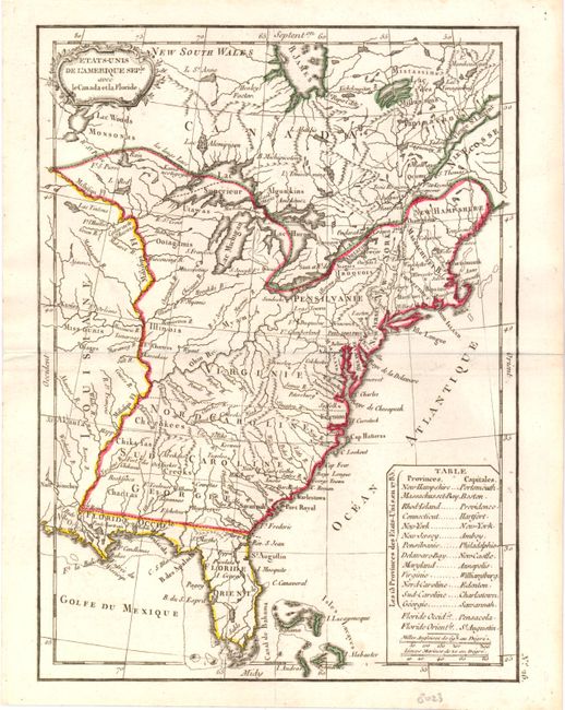
Auction 142, Lot 135
Subject: United States and Canada
Delamarche, Charles Francois
Etats-Unis de l'Amerique Seple. avec le Canada et la Floride, 1793
Size: 7.3 x 9.8 inches (18.5 x 24.9 cm)
Estimate: $200 - $240
Sold for: $150
Closed on 11/28/2012
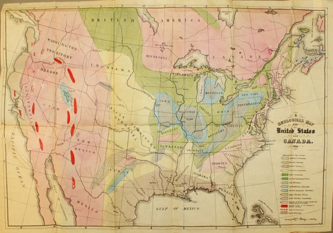
Auction 142, Lot 136
Subject: United States and Canada
Hitchcock, Edward
[Maps with Report] A Geological Map of the United States and Canada [and] Outline of the Geology of the Globe, 1853
Size: See Description
Estimate: $1,000 - $1,300
First Edition of Hitchcock's Important Maps and Report
Sold for: $1,300
Closed on 11/28/2012
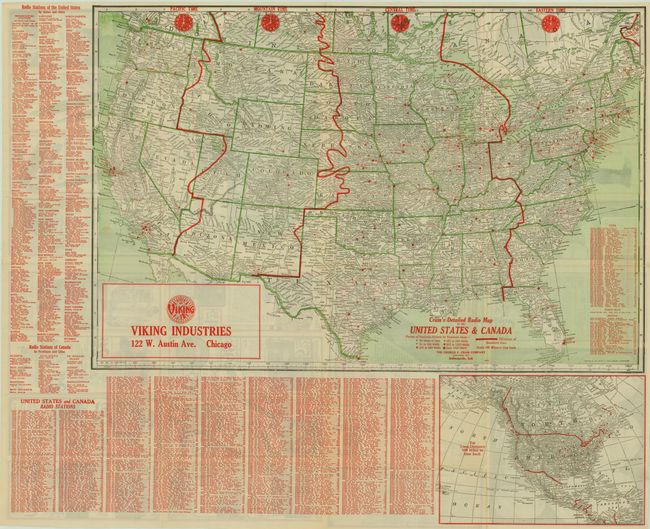
Auction 142, Lot 137
Subject: United States and Canada
Cram, George F. & Company
Cram's Detailed Radio Map of the United States and Canada, 1926
Size: 29 x 19.3 inches (73.7 x 49 cm)
Estimate: $200 - $300
Sold for: $150
Closed on 11/28/2012
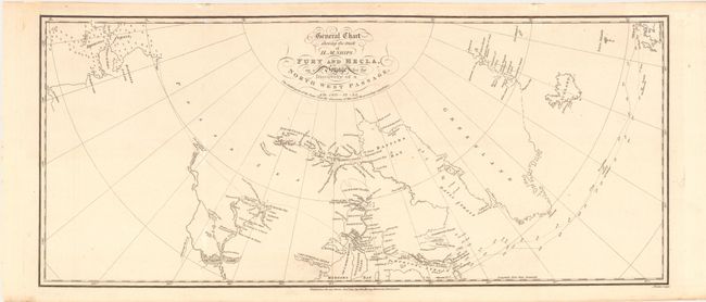
Auction 142, Lot 138
Subject: Northern Canada & United States
Parry, William Edward (Adm. Sir)
General Chart Shewing the Track of H. M. Ships Fury and Hecla, on a Voyage for the Discovery of a North West Passage, AD. 1821-22-23, 1824
Size: 23.5 x 10 inches (59.7 x 25.4 cm)
Estimate: $375 - $450
Sold for: $190
Closed on 11/28/2012
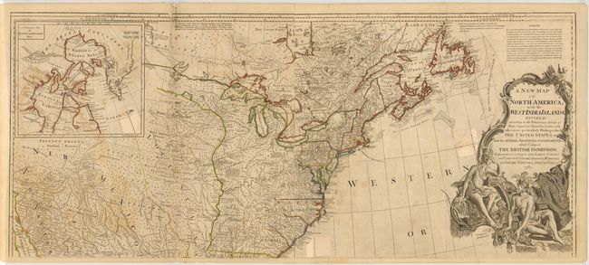
Auction 142, Lot 139
Subject: Eastern Canada & United States
Sayer, Robert
A New Map of North America; with the West India Islands..., 1783
Size: 46.3 x 20.1 inches (117.6 x 51.1 cm)
Estimate: $1,100 - $1,300
Unsold
Closed on 11/28/2012
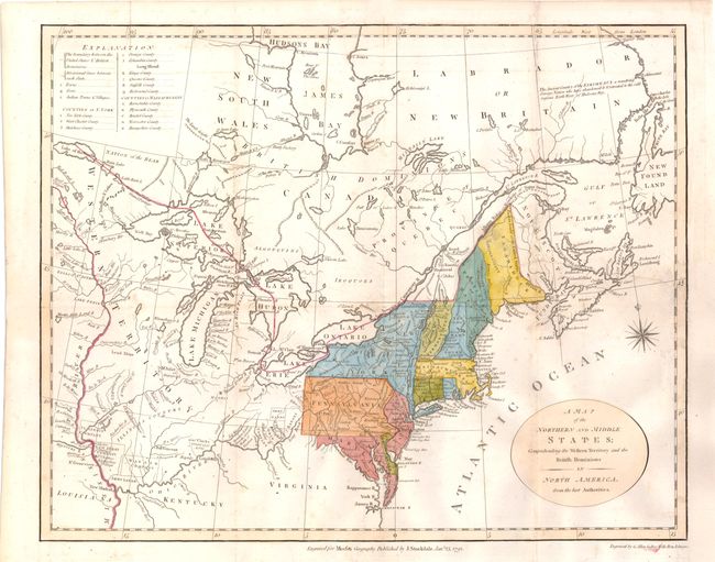
Auction 142, Lot 140
Subject: Eastern Canada & United States
Stockdale, John
A Map of the Northern and Middle States; Comprehending the Western Territory and the British Dominions in North America. From the Best Authorities, 1792
Size: 15.7 x 12.5 inches (39.9 x 31.8 cm)
Estimate: $700 - $850
Sold for: $500
Closed on 11/28/2012
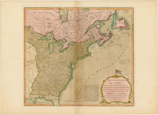
Auction 142, Lot 141
Subject: Eastern Canada & United States
Laurie & Whittle
The United States of America with the British Possessions of Canada, Nova Scotia, New Brunswick and Newfoundland Divided with the French, also the Spanish Territories of Louisiana and Florida According to the Preliminary Articles of Peace…, 1794
Size: 19.8 x 18 inches (50.3 x 45.7 cm)
Estimate: $1,100 - $1,300
Unsold
Closed on 11/28/2012
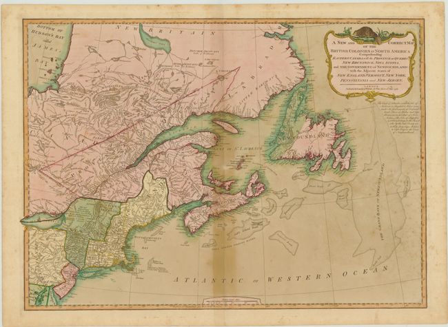
Auction 142, Lot 142
Subject: Eastern Canada & United States
Laurie & Whittle
A New and Correct Map of the British Colonies in North America Comprehending Eastern Canada with the Province of Quebec, New Brunswick, Nova Scotia, ... Newfoundland: with the Adjacent States of New England, Vermont, New York, Pennsylvania and New Jersey, 1794
Size: 25.8 x 18.5 inches (65.5 x 47 cm)
Estimate: $600 - $750
Sold for: $300
Closed on 11/28/2012
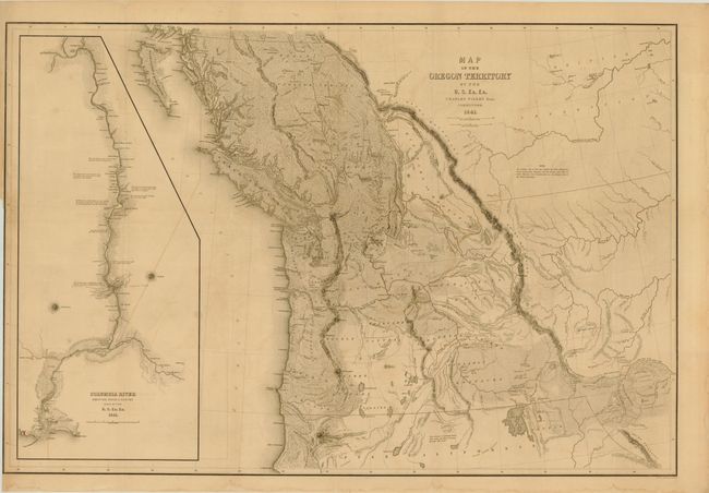
Auction 142, Lot 143
Subject: Western Canada & United States
Wilkes, Charles
Map of the Oregon Territory by the U.S. Ex. Ex., 1841
Size: 33.8 x 22.8 inches (85.9 x 57.9 cm)
Estimate: $1,500 - $2,000
Sold for: $1,100
Closed on 11/28/2012
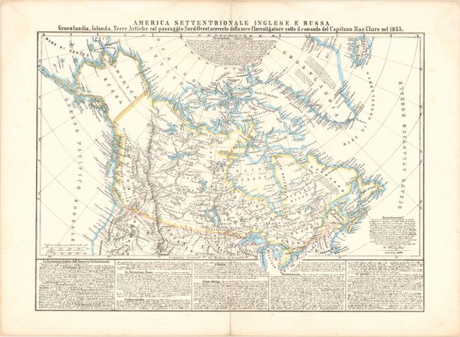
Auction 142, Lot 144
Subject: Canada & Northern United States
Marzolla, Benedetto
America Settentrionale Inglese E Russa…, 1854
Size: 23.5 x 18 inches (59.7 x 45.7 cm)
Estimate: $275 - $350
Unsold
Closed on 11/28/2012
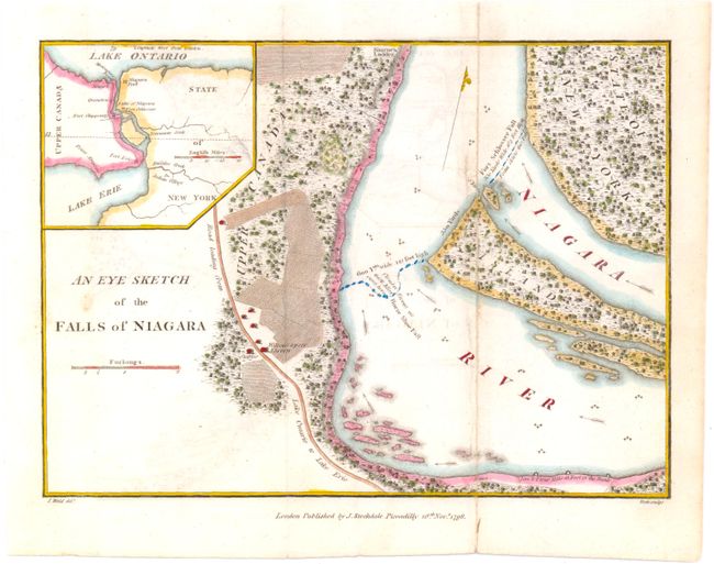
Auction 142, Lot 145
Subject: United States & Canada - Niagara Falls
Stockdale, John
An Eye Sketch of the Falls of Niagara, 1798
Size: 9 x 6.5 inches (22.9 x 16.5 cm)
Estimate: $80 - $100
Sold for: $40
Closed on 11/28/2012
27 lots