Subject: Colonial United States & Canada, St. Lawrence River
Period: 1775 (dated)
Publication: The American Atlas
Color: Hand Color
Size:
37.5 x 23.5 inches
95.3 x 59.7 cm
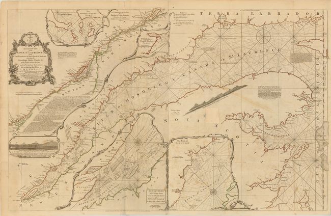
This large-scale map of the St. Lawrence River was first issued in 1757. It is based on the surveys of Jean Desayes with an updated depiction of the river from Lake Ontario to Quebec based on D'Anville. This great navigational chart is complete with soundings, rhumb lines, sailing directions, and coastal profiles. The central part of the map shows the river from Anticosti Island to Quebec, and it includes a number of insets depicting important sections of the river with greater detail. First issued in 1757, it was reissued in 1775 by Sayer and Bennet prompted by the growing tensions between the British government and its colonies, that generated an increasing demand for maps of North America. Printed on two sheets, joined as issued.
References: Kershaw #669; Stevens & Tree 76-d.
Condition: B
Issued folding on heavy, watermarked paper with original outline color. There is offsetting, light scattered foxing, and several fold separations that have been closed on verso with archival tape. A previous owner stamped the recto in an unengraved area (just to the right of center), which has since been covered with old paper. There are a couple of tiny unrepaired tears in the inset of the "Passage from Cape Torment…"