Filtered by Category:Canada(Show All Categories)
Showing results for:Auction 132
Catalog Archive
21 lots
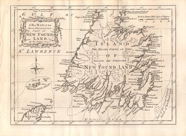
Auction 132, Lot 106
Subject: Newfoundland, Canada
Kitchin, Thomas
A New Map, of the Most Frequented Part of New Foundland, 1762
Size: 9.5 x 7 inches (24.1 x 17.8 cm)
Estimate: $180 - $220
Sold for: $130
Closed on 6/2/2010
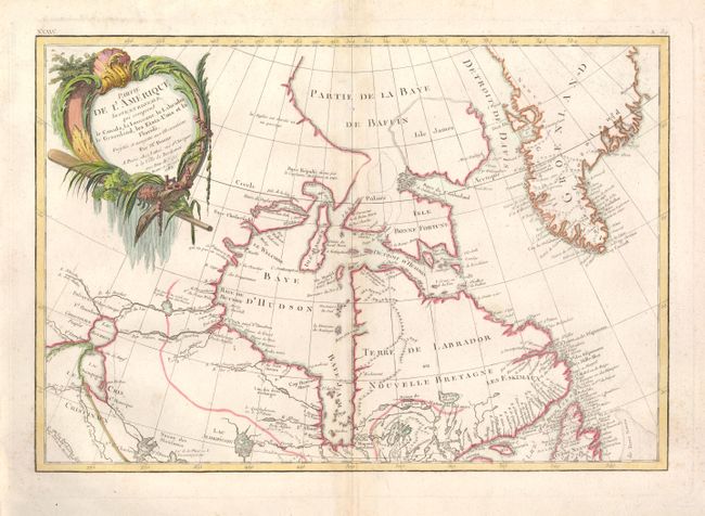
Auction 132, Lot 107
Subject: Canada
Bonne/Lattre
Partie de l'Amerique Septentrionale, qui comprend le Canada, la Louisiane, le Labrador, le Groenland, les Etats-Unis et la Floride, 1783
Size: 17.3 x 11.8 inches (43.9 x 30 cm)
Estimate: $200 - $250
Unsold
Closed on 6/2/2010
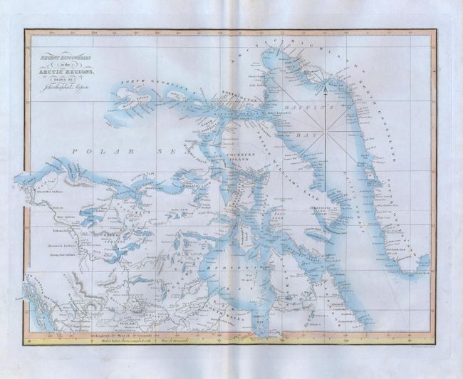
Auction 132, Lot 108
Subject: Canada
Aspin, Jehoshaphat
Recent Discoveries in the Arctic Regions, 1826
Size: 17 x 13 inches (43.2 x 33 cm)
Estimate: $200 - $250
Sold for: $150
Closed on 6/2/2010
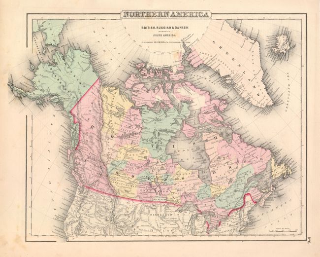
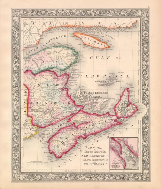
Auction 132, Lot 109
Subject: Canada
Colton, Joseph Hutchins
[Lot of 4 - Canada], 1855
Size: See Description
Estimate: $140 - $180
Sold for: $100
Closed on 6/2/2010
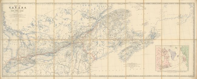
Auction 132, Lot 110
Subject: Canada
Johnston, W. & A.K.
Map of Canada with Part of New Brunswick & Nova Scotia. Shewing the Line of Grand Trunk Railway and its Connections, 1860
Size: 45.3 x 17.7 inches (115.1 x 45 cm)
Estimate: $220 - $275
Sold for: $150
Closed on 6/2/2010
Auction 132, Lot 111
Subject: Canada
Mitchell, Samuel Augustus
[Lot of 3 - Canada], 1860
Size: See Description
Estimate: $120 - $160
Sold for: $120
Closed on 6/2/2010
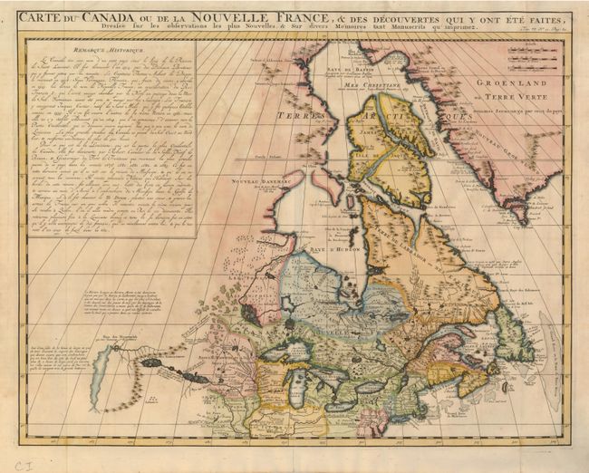
Auction 132, Lot 112
Subject: Colonial United States & Canada
Chatelain, Henry Abraham
Carte du Canada ou de la Nouvelle France, & des Decouvertes qui y ont ete Faites, Dressee sur les observations les plus Nouvelles, & sur divers Memoires tant Manuscrits qu' imprimez, 1719
Size: 20.4 x 15.8 inches (51.8 x 40.1 cm)
Estimate: $900 - $1,100
Sold for: $850
Closed on 6/2/2010
Auction 132, Lot 113
Subject: Canada and Great Lakes
Robert de Vaugondy, Didier
Partie de l'Amerique Septent? qui comprend la Nouvelle France ou le Canada, 1755
Size: 23.8 x 17.8 inches (60.5 x 45.2 cm)
Estimate: $800 - $950
Unsold
Closed on 6/2/2010
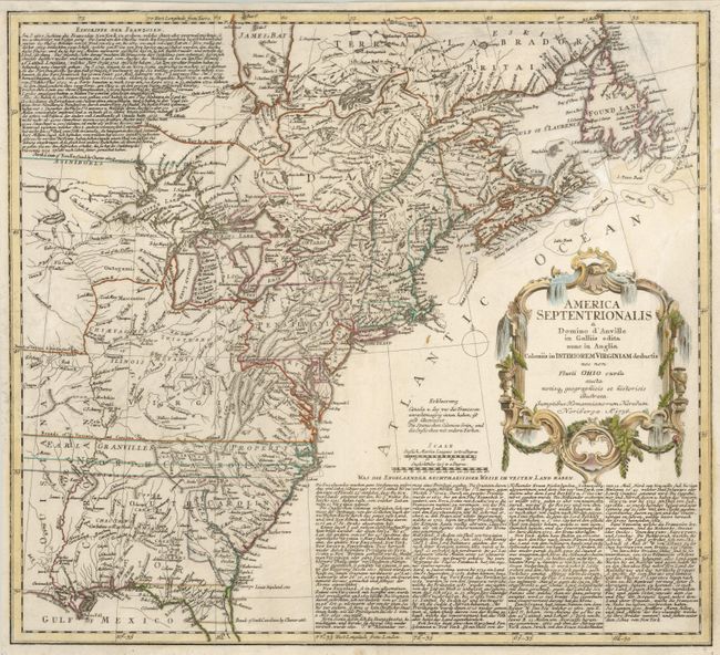
Auction 132, Lot 114
Subject: Colonial United States and Canada
Homann Heirs
America Septentrionalis a Domino d'Anville in Galliis edita nunc in Anglia Coloniis in Interiorem Virginiam deductis nec non Fluvii Ohio cursu…, 1756
Size: 20 x 18 inches (50.8 x 45.7 cm)
Estimate: $500 - $600
Sold for: $475
Closed on 6/2/2010
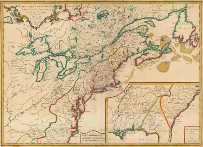
Auction 132, Lot 115
Subject: Colonial United States and Canada
Longchamp, S. G. (Sieur)
Carte des Possessions Francoises et Angloises dans le Canada, et Partie de la Louisiane, 1756
Size: 30 x 22 inches (76.2 x 55.9 cm)
Estimate: $950 - $1,200
Sold for: $650
Closed on 6/2/2010
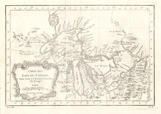
Auction 132, Lot 116
Subject: Colonial Great Lakes
Bellin, Jacques Nicolas
Carte des Lacs du Canada…, 1757
Size: 11.4 x 7.6 inches (29 x 19.3 cm)
Estimate: $500 - $600
Sold for: $375
Closed on 6/2/2010
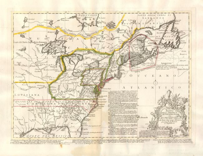
Auction 132, Lot 117
Subject: Colonial United States and Canada
Bellin, Jacques Nicolas
Mappa dell'America Settentrionale ove sono rappresentati esattam, i Paesi e loro limiti controversi che hanno dato motiva…, 1758
Size: 15 x 10.6 inches (38.1 x 26.9 cm)
Estimate: $600 - $700
Sold for: $350
Closed on 6/2/2010
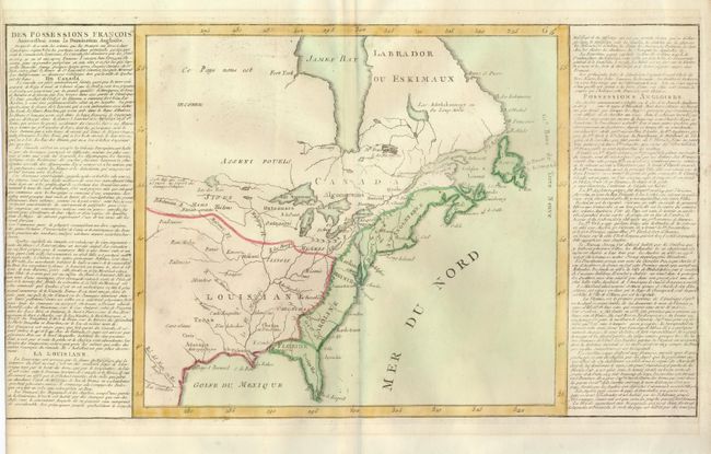
Auction 132, Lot 118
Subject: Colonial United States and Canada
Clouet, Jean Baptiste Louis
[Des Possessions Francoises Aujourd'hui sous la Domination Angloises ...], 1767
Size: 13.7 x 12.3 inches (34.8 x 31.2 cm)
Estimate: $300 - $375
Sold for: $220
Closed on 6/2/2010
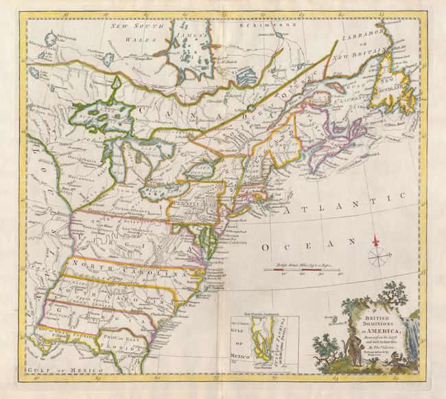
Auction 132, Lot 119
Subject: Colonial United States and Canada
Kitchin, Thomas
British Dominions in America, Drawn from the latest and best Authorities, 1771
Size: 14.7 x 13.3 inches (37.3 x 33.8 cm)
Estimate: $475 - $550
Sold for: $650
Closed on 6/2/2010
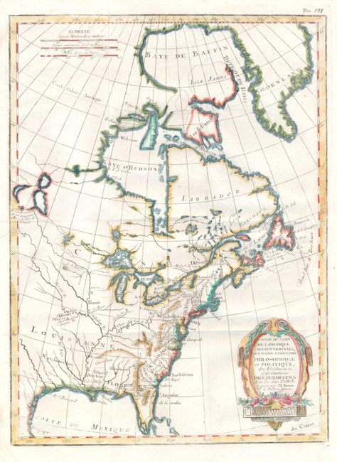
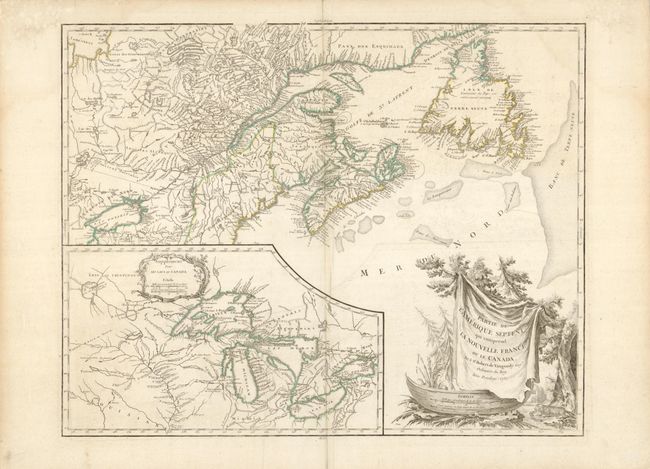
Auction 132, Lot 120
Subject: Colonial United States and Canada
Bonne, Rigobert
Partie du Nord de l'Amerique Septentrionale pour Servir a l'Histoire Philosophique et Politique…, 1774
Size: 9.3 x 12.6 inches (23.6 x 32 cm)
Estimate: $200 - $240
Sold for: $160
Closed on 6/2/2010
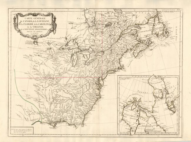
Auction 132, Lot 121
Subject: Colonial United States and Canada
D'Anville/Santini
Carte Generale du Canada, de la Louisiane, de la Floride, de la Caroline, de la Virginie, de la Nouvelle Angleterre etc. par le Sr. d'Anville, 1776
Size: 25.8 x 18.8 inches (65.5 x 47.8 cm)
Estimate: $950 - $1,100
Unsold
Closed on 6/2/2010
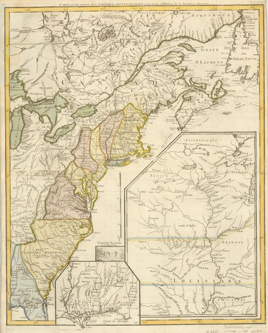
Auction 132, Lot 122
Subject: Canada & United States
Le Rouge, George Louis
Carte d'une Partie de l'Amerique Septentrionale, pour servir a l'Histoire de la derniere Guerre, 1787
Size: 19.5 x 24.2 inches (49.5 x 61.5 cm)
Estimate: $1,600 - $2,000
Unsold
Closed on 6/2/2010
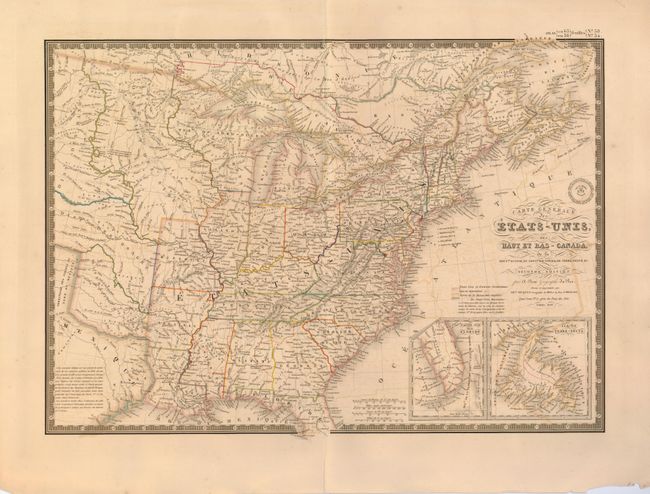
Auction 132, Lot 123
Subject: Canada & United States
Brue, Adrien Hubert
Carte Generale des Etats-Unis, Des Haut et Bas-Canada…, 1838
Size: 20.3 x 14.3 inches (51.6 x 36.3 cm)
Estimate: $180 - $240
Sold for: $130
Closed on 6/2/2010
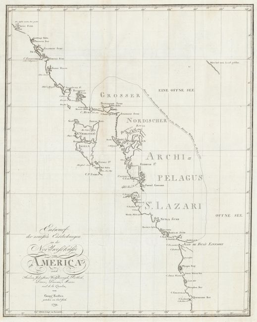
Auction 132, Lot 124
Subject: Western Canada & United States
Forster, Georg
Entwurf der neuesten Entdeckungen an der Nordwestkuste von America, 1791
Size: 18.5 x 23.5 inches (47 x 59.7 cm)
Estimate: $500 - $600
Sold for: $350
Closed on 6/2/2010
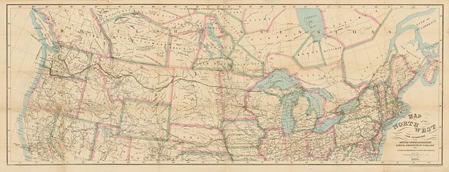
Auction 132, Lot 125
Subject: Western Canada & United States
Bien, Julius
Map of the North West from Explorations by the United States Engineers & Royal Engineers of England and Union & Northern Pacific R.R. Surveys, 1870
Size: 41 x 15.3 inches (104.1 x 38.9 cm)
Estimate: $180 - $220
Sold for: $140
Closed on 6/2/2010
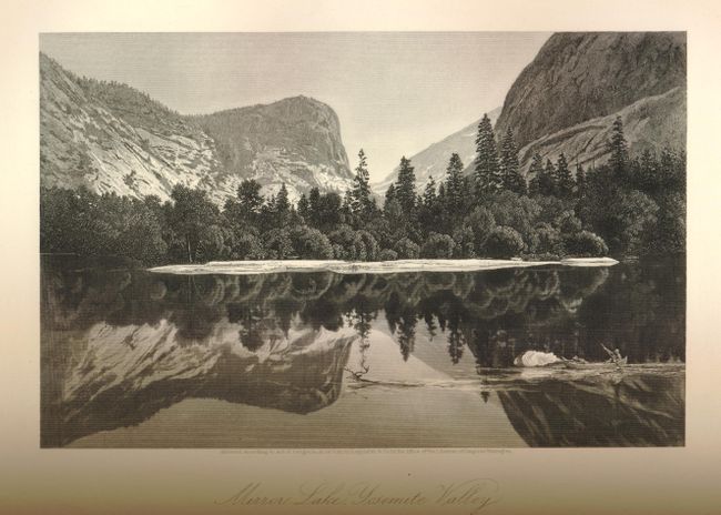
Auction 132, Lot 748
Subject: Miscellaneous Books
Bryant, William C.
Picturesque America; or, the Land we Live in… Volume I, 1872
Size: 11 x 13 inches (27.9 x 33 cm)
Estimate: $200 - $250
Sold for: $150
Closed on 6/2/2010
21 lots