Subject: Canada
Period: 1826 (circa)
Publication:
Color: Hand Color
Size:
17 x 13 inches
43.2 x 33 cm
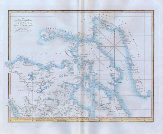
The region shown is from the Queen Charlotte Islands and Mackenzie Bay in the West to the western edge of Greenland. The Mackenzie Mountains are here called the Rocky Mountains, and Baffin Island is named as Prince William's Land. Names many Indian lands including Nausend, Nagiler, Amah, Blackfoot, Knisteneaux, Cree, Copper, Hare, Nathana, Mountain, Strong Bow, and Nena Wewhok plus the land of the Eskimo in the far north. The map names the regions of New Norfolk, New Cornwall, North Wales, New South Wales, Eastmain, Labrador, Prince Williams' Land and more including good detail on the watershed and mountains. Locates the forts of Hope, Norman, Simpson, Resolution, Enterprise, Peace River, Moose, George, Augustus, and several more. The overland travels of Alexander Mackenzie in 1793 seem to have provided most of the information for the inland region west of Hudson Bay. The map was published in the same atlas as the geographical game maps created by Gautltier. A handsome map with blue wash along the coastlines and a horological addition at the bottom, Hours before Noon, compared with Time at Greenwich below the Longitude scale.
References:
Condition: A+
Beautiful, flawless example with bright original color and dark impression.