Catalog Archive
Auction 132, Lot 110

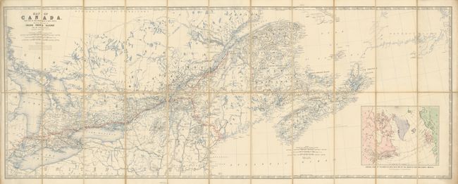
"Map of Canada with Part of New Brunswick & Nova Scotia. Shewing the Line of Grand Trunk Railway and its Connections", Johnston, W. & A.K.

Subject: Canada

Period: 1860 (dated)

Publication:

Color: Printed Color

Size:
45.3 x 17.7 inches
115.1 x 45 cm
Download High Resolution Image
(or just click on image to launch the Zoom viewer)

This rarely seen railroad map uses red overprinting to delineate the rail route which extends in the west from Detroit across the region to Rinege du Loup with another branch reaching south to Portland Maine. Many other rail lines are named and drawn in black. Large inset "General View of the North Atlantic with Part of the Coasts of Europe & North America" which includes the route of HMS Hero. The linen-backed segmented map folds into red cloth covers with embossed gilt titling and image of an Indian headdress.

References:

Condition: A

Map is near fine with a few splits on fold intersections of linen.

Estimate: $220 - $275

Sold for: $150

Closed on 6/2/2010

Archived