Filtered by Category:Canada(Show All Categories)
Showing results for:Auction 115
Catalog Archive
24 lots
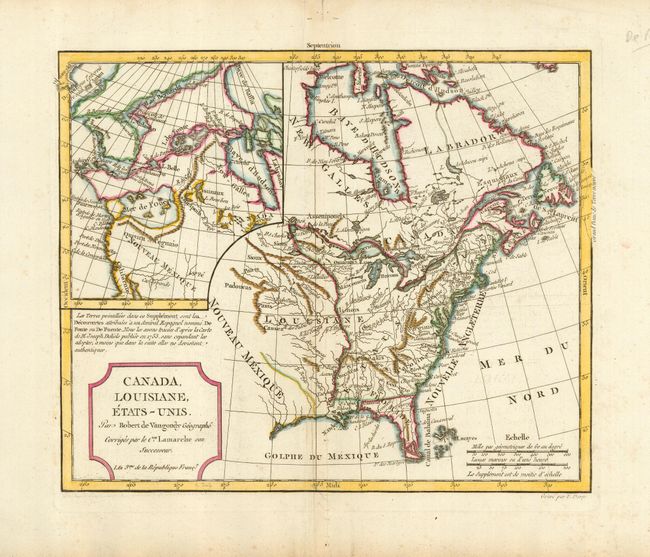
Auction 115, Lot 102
Subject: Canada & United States
Robert de Vaugondy/Delamarche
Canada, Louisiane, Etats-Unis, 1795
Size: 11.3 x 9.4 inches (28.7 x 23.9 cm)
Estimate: $230 - $300
Sold for: $210
Closed on 6/21/2006
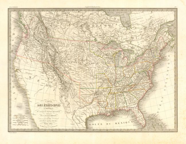
Auction 115, Lot 104
Subject: United States & Canada
Lapie, Alexander Emile & Pierre
Carte des Etats-Unis d'Amerique, du Canada, du Nouveau Brunswick et d'une partie de la Nouvelle Bretagne, 1832
Size: 21 x 15 inches (53.3 x 38.1 cm)
Estimate: $300 - $400
Unsold
Closed on 6/21/2006
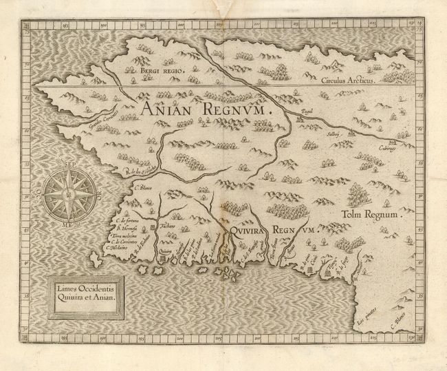
Auction 115, Lot 111
Subject: Western Canada & Alaska
Wytfliet, Cornelis
Limes Occidentis Quivira et Anian, 1607
Size: 11.5 x 9.2 inches (29.2 x 23.4 cm)
Estimate: $1,900 - $2,100
Unsold
Closed on 6/21/2006
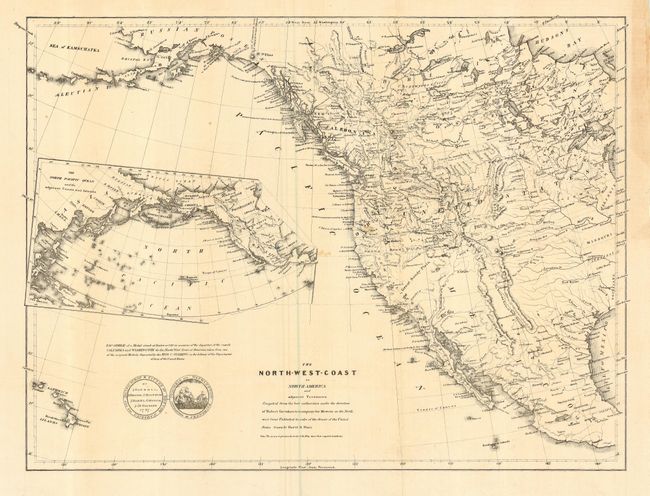
Auction 115, Lot 114
Subject: Western North America
Greenhow, Robert
The North-West Coast of North America and adjacent Territories…, 1840
Size: 21.3 x 16 inches (54.1 x 40.6 cm)
Estimate: $350 - $450
Sold for: $250
Closed on 6/21/2006
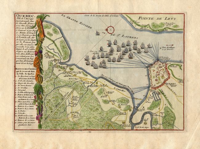
Auction 115, Lot 115
Subject: Canada, Quebec
Fer, Nicolas de
Quebec Ville de l'Amerique Septentrionale, dans la Nouvelle France…, 1696
Size: 11.6 x 8 inches (29.5 x 20.3 cm)
Estimate: $230 - $275
Sold for: $275
Closed on 6/21/2006
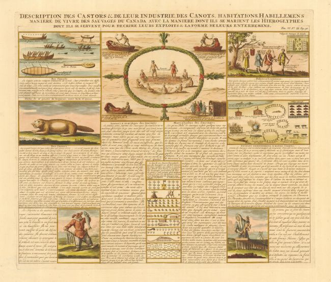
Auction 115, Lot 116
Subject: Canada
Chatelain, Henry Abraham
Description des Castors & de leur Industrie des Canots…des Sauvages du Canada, 1719
Size: 17.3 x 14.8 inches (43.9 x 37.6 cm)
Estimate: $240 - $300
Sold for: $180
Closed on 6/21/2006
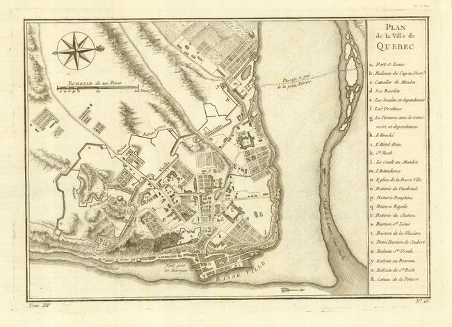
Auction 115, Lot 117
Subject: Canada, Quebec
Bellin, Jacques Nicolas
Plan de la Ville de Quebec, 1757
Size: 11 x 7.8 inches (27.9 x 19.8 cm)
Estimate: $230 - $275
Sold for: $170
Closed on 6/21/2006
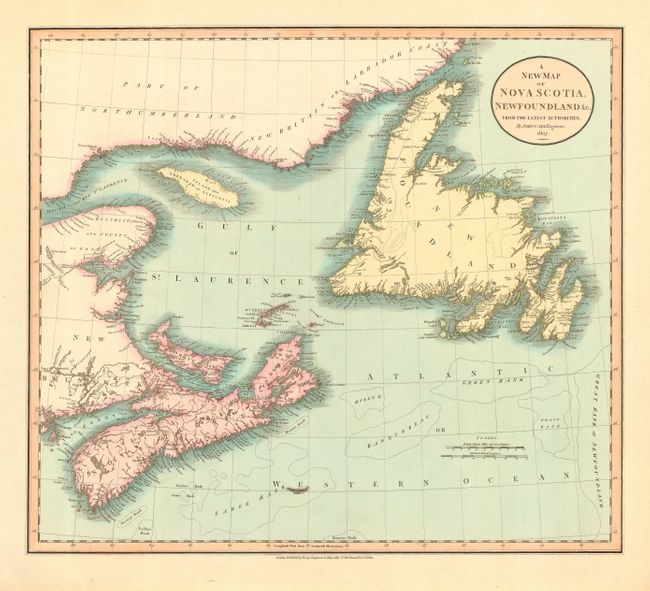
Auction 115, Lot 118
Subject: Canada
Cary, John
A New Map of Nova Scotia, Newfoundland &c. from the Latest Authorities, 1807
Size: 20.4 x 18 inches (51.8 x 45.7 cm)
Estimate: $200 - $250
Sold for: $200
Closed on 6/21/2006
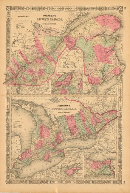
Auction 115, Lot 119
Subject: Canada
[Lot of 4 - Canada], 1855-73
Size: See Description
Estimate: $120 - $160
Sold for: $80
Closed on 6/21/2006
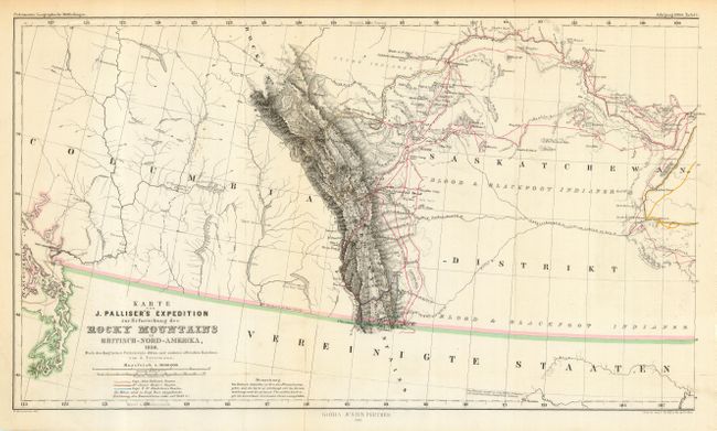
Auction 115, Lot 120
Subject: Canada
Perthes, Justus
[Lot of 2] Karte von J. Palliser's Expedition zur Erforschung der Rocky Mountains Britisch-Nord-Amerika, 1858. [and] Karte der Red River Expedition in Britisch Nord-Amerika unter Gladman, Hind, Napier, Dawson, &c. 1857 und 1858., 1860
Size: 17.5 x 9.5 inches (44.5 x 24.1 cm)
Estimate: $200 - $300
Sold for: $250
Closed on 6/21/2006
Auction 115, Lot 121
Subject: Colonial United States and Canada
Homann, Johann Baptist
Amplissimae Regionis Mississipi Seu Provinciae Ludovicianae…, 1730
Size: 23 x 19.3 inches (58.4 x 49 cm)
Estimate: $2,100 - $2,400
Sold for: $1,800
Closed on 6/21/2006
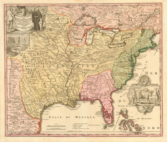
Auction 115, Lot 122
Subject: Colonial United States and Canada
Homann Heirs
Dominia Anglorum in America Septentrionali, 1740
Size: 21.8 x 19.8 inches (55.4 x 50.3 cm)
Estimate: $900 - $1,100
Sold for: $450
Closed on 6/21/2006
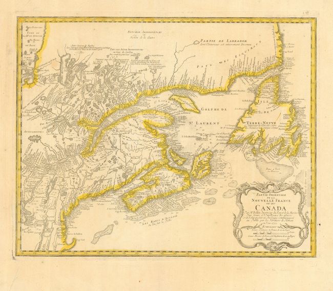
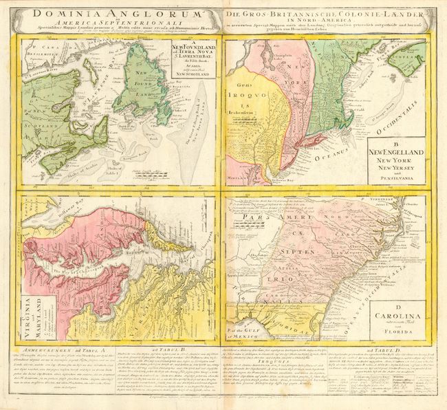
Auction 115, Lot 123
Subject: Colonial United States and Canada
Homann Heirs
Partie Orientale de la Nouvelle France ou du Canada, 1755
Size: 21.2 x 16.8 inches (53.8 x 42.7 cm)
Estimate: $550 - $650
Unsold
Closed on 6/21/2006
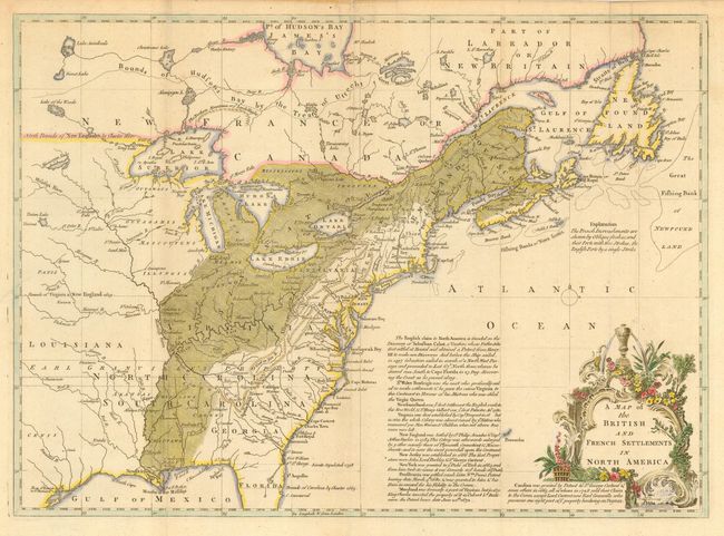
Auction 115, Lot 124
Subject: Colonial United States and Canada
Lodge, John
A Map of the British and French Settlements in North America, 1755
Size: 15.3 x 11 inches (38.9 x 27.9 cm)
Estimate: $550 - $650
Sold for: $750
Closed on 6/21/2006
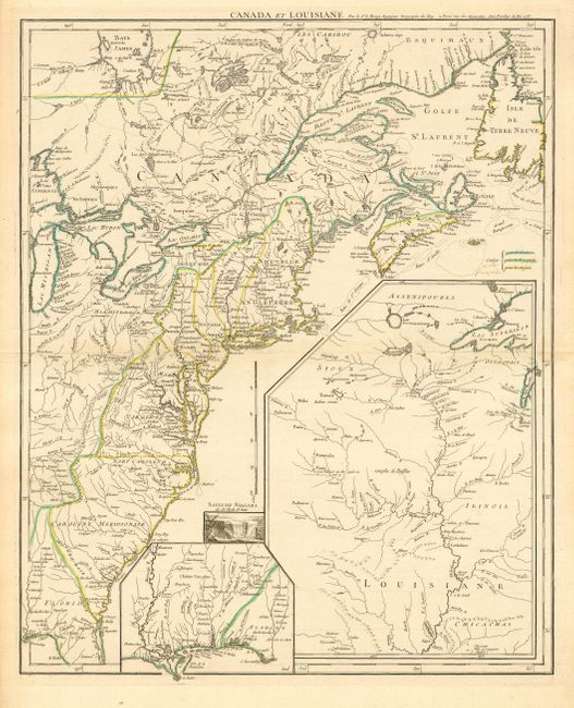
Auction 115, Lot 125
Subject: Colonial United States and Canada
Le Rouge, George Louis
Canada et Louisiane…, 1755
Size: 19.6 x 24 inches (49.8 x 61 cm)
Estimate: $1,700 - $2,000
Sold for: $1,700
Closed on 6/21/2006
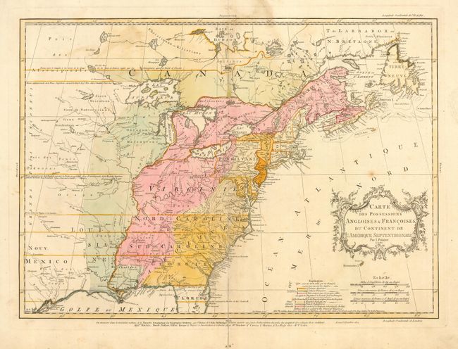
Auction 115, Lot 126
Subject: Colonial United States and Canada
Palairet, Jean
Carte des Possessions Angloises & Francoises du Continent de l'Amerique Septentrionale, 1756
Size: 22.5 x 16.7 inches (57.2 x 42.4 cm)
Estimate: $2,200 - $2,400
Unsold
Closed on 6/21/2006
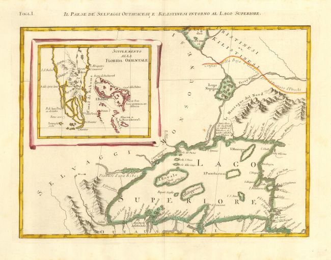
Auction 115, Lot 127
Subject: Colonial Great Lakes and Florida and Bahamas
Zatta, Antonio
Il Paese de Selvaggi Outauacesi e Kilistinesi Intorno al Lago Superiore, 1778
Size: 16.5 x 12 inches (41.9 x 30.5 cm)
Estimate: $350 - $400
Sold for: $250
Closed on 6/21/2006
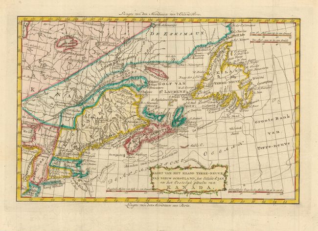
Auction 115, Lot 129
Subject: Eastern Canada & United States
Bachiene, Willem Albert
Kaart van het Eiland Terre-Neuve, van Nieuw Schotland, het Eiland St. Jan en het Oostelyk gedeelte van Kanada, 1785
Size: 12.5 x 8.5 inches (31.8 x 21.6 cm)
Estimate: $275 - $325
Sold for: $275
Closed on 6/21/2006
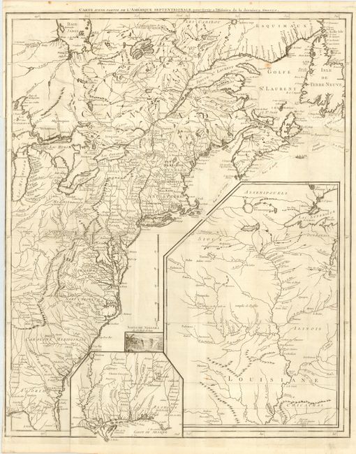
Auction 115, Lot 130
Subject: United States & Canada
Le Rouge, George Louis
Carte d'une Partie de l'Amerique Septentrionale, pour servir a l'Histoire de la derniere Guerre, 1787
Size: 19.5 x 24.2 inches (49.5 x 61.5 cm)
Estimate: $1,500 - $1,700
Unsold
Closed on 6/21/2006
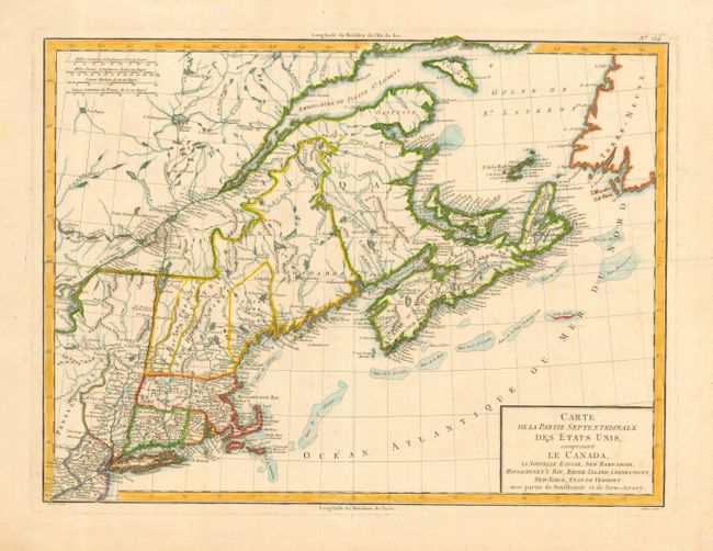
Auction 115, Lot 131
Subject: Eastern Canada & United States
Tardieu
Carte de la Partie Septentrionale des Etats Unis, comprenant le Canada, La Nouvelle Ecosse, New Hampshire, Massachuset's Bay, Rhode-Island, Connecticut, New-Yorck, Etat de Vermont avec partie de Pensilvanie et de New-Jersey, 1797
Size: 17 x 13 inches (43.2 x 33 cm)
Estimate: $350 - $400
Unsold
Closed on 6/21/2006
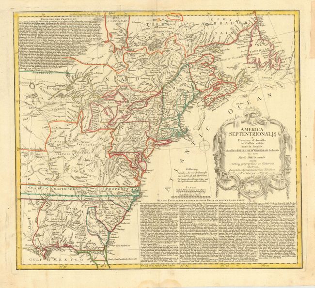
Auction 115, Lot 154
Subject: Colonial United States and Canada
Homann Heirs
America Septentrionalis a Domino d'Anville in Galliis edita nunc in Anglia Coloniis in Interiorem Virginiam deductis nec non Fluvii Ohio cursu…, 1756
Size: 19.8 x 17.8 inches (50.3 x 45.2 cm)
Estimate: $800 - $900
Unsold
Closed on 6/21/2006
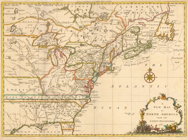
Auction 115, Lot 156
Subject: Colonial United States and Canada
Spilsbury, J.
A New Map of North America from the Latest Discoveries, 1761
Size: 15 x 11 inches (38.1 x 27.9 cm)
Estimate: $375 - $450
Sold for: $550
Closed on 6/21/2006
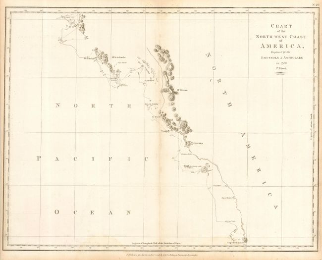
Auction 115, Lot 208
Subject: Western Canada & United States
La Perouse, Comte Jean F. Galoup, de
Chart of the North west Coast of America, Explored by the Boussole & Astrolabe in 1786. 2d. Sheet, 1798
Size: 19.5 x 15 inches (49.5 x 38.1 cm)
Estimate: $200 - $300
Sold for: $130
Closed on 6/21/2006
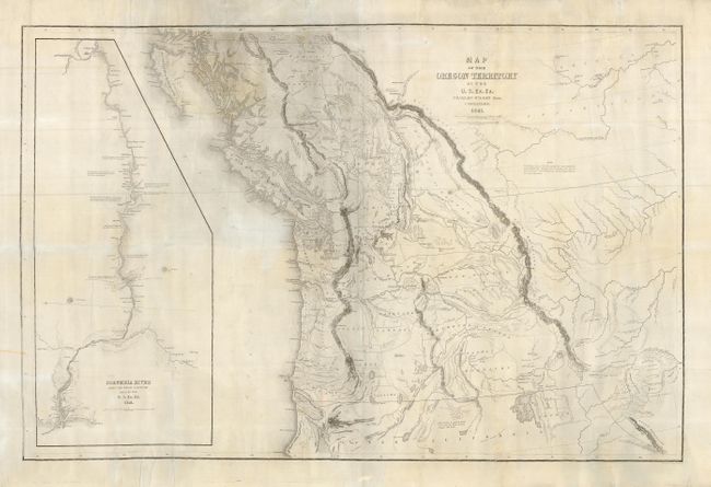
Auction 115, Lot 209
Subject: United States - Northwestern
Wilkes, Charles
Map of the Oregon Territory by the U.S. Ex. Ex, 1841
Size: 34.5 x 22.8 inches (87.6 x 57.9 cm)
Estimate: $1,600 - $2,000
Sold for: $1,200
Closed on 6/21/2006
24 lots