Showing Featured Lots(remove filter)
Showing results for:Auction 192
Catalog Archive
45 lots
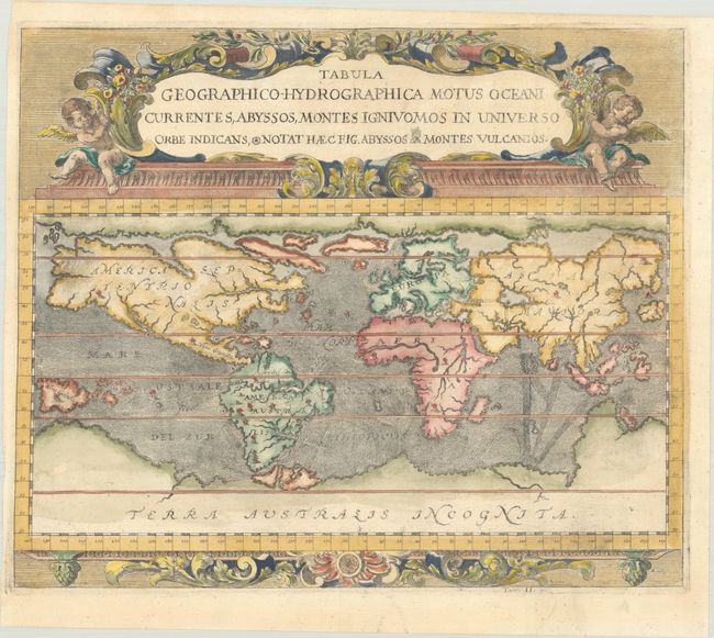
Auction 192, Lot 8
Subject: World
Zahn, Johannes
Tabula Geographico-Hydrographica Motus Oceani Currentes, Abyssos, Montes Igniuomos in Universo Orbe Indicans..., 1696
Size: 16.7 x 14 inches (42.4 x 35.6 cm)
Estimate: $1,600 - $1,900
Early Example of Thematic Cartography
Sold for: $1,200
Closed on 4/26/2023
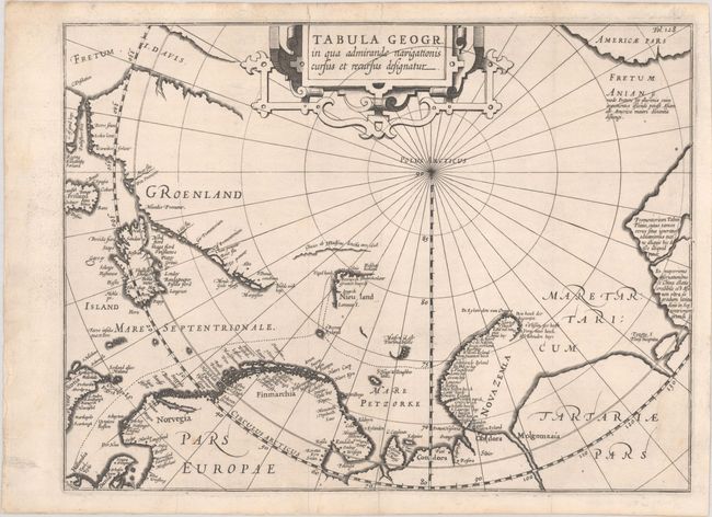
Auction 192, Lot 48
Subject: North Pole
Pontanus, Johannes Isaksen
Tabula Geogr. in qua admirandae navigationis cursus et recursus designatur, 1611
Size: 14 x 10.5 inches (35.6 x 26.7 cm)
Estimate: $1,800 - $2,100
Scarce Map Showing Barentsz' Voyage to Find a Northeast Passage
Sold for: $900
Closed on 4/26/2023
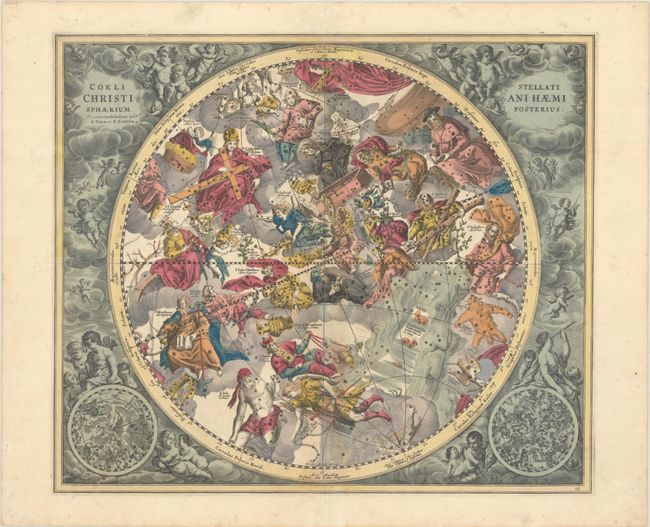
Auction 192, Lot 55
Subject: Celestial
Cellarius/Schenk & Valck
Coeli Stellati Christiani Haemisphaerium Posterius, 1708
Size: 20.2 x 17.3 inches (51.3 x 43.9 cm)
Estimate: $2,750 - $3,500
Superb Celestial Chart with Christian Symbolism in Full Contemporary Color
Sold for: $1,900
Closed on 4/26/2023
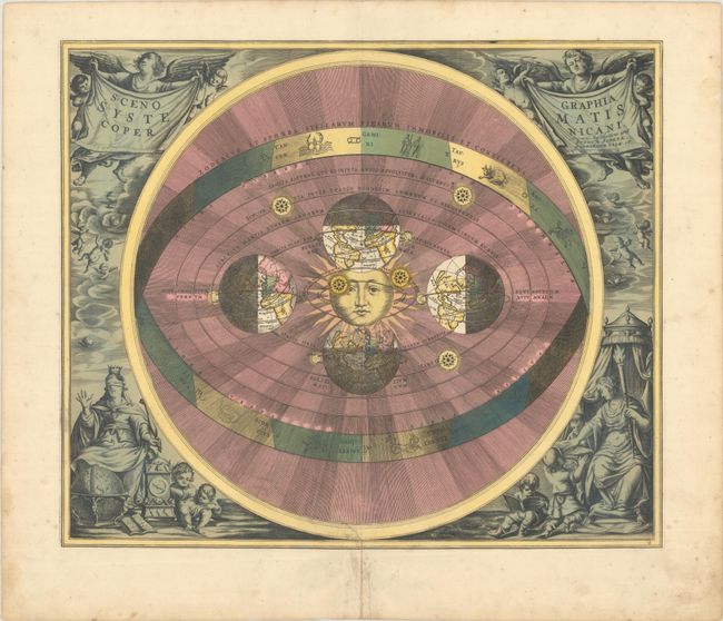
Auction 192, Lot 59
Subject: Solar System
Cellarius/Schenk & Valck
Scenographia Systematis Copernicani, 1708
Size: 19.9 x 16.8 inches (50.5 x 42.7 cm)
Estimate: $3,500 - $4,500
Cellarius' Striking Chart of the Copernican Cosmography
Sold for: $2,000
Closed on 4/26/2023
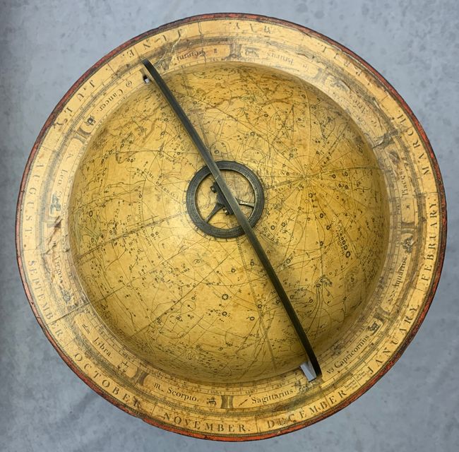
Auction 192, Lot 65
Subject: Celestial Globe
Bardin, William & T. M.
The New Twelve Inch British Celestial Globe, Containing the Exact Positions of More Than 3,800 Fix'd Stars, Nebulae, Planetary Nebulae, &c..., 1800
Size: 42 x 20 inches (106.7 x 50.8 cm)
Estimate: $6,000 - $7,500
A Gorgeous Celestial Globe with Floor Stand
Sold for: $4,250
Closed on 4/26/2023
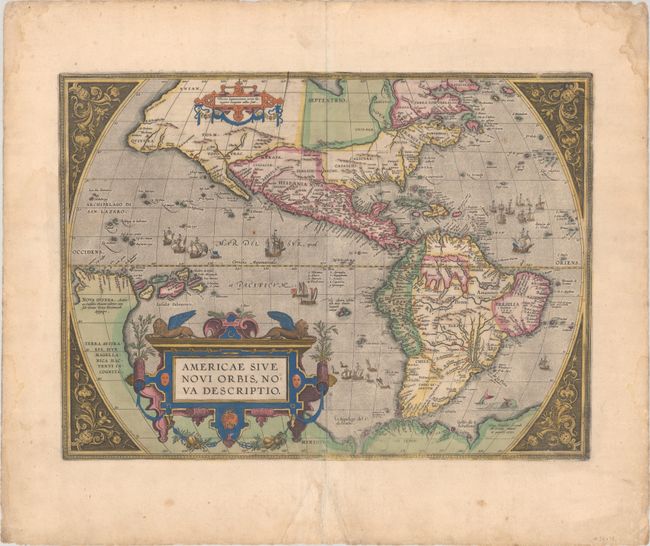
Auction 192, Lot 73
Subject: Western Hemisphere - America
Ortelius, Abraham
Americae sive Novi Orbis, Nova Descriptio, 1587
Size: 19 x 13.9 inches (48.3 x 35.3 cm)
Estimate: $5,500 - $6,500
Ortelius' Influential Map of the New World in Full Contemporary Color
Sold for: $4,000
Closed on 4/26/2023
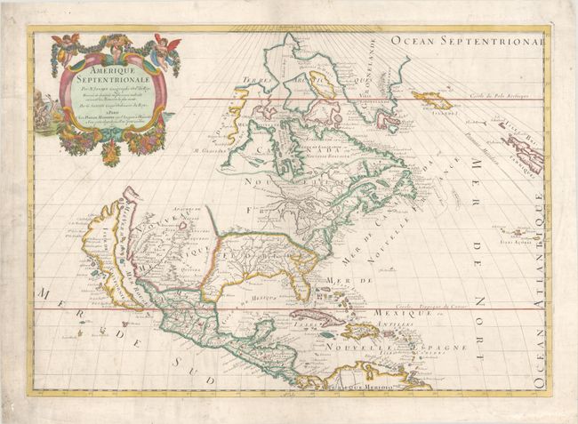
Auction 192, Lot 88
Subject: Colonial North America
Sanson/Mariette
Amerique Septentrionale par N. Sanson..., 1669
Size: 21.9 x 15.6 inches (55.6 x 39.6 cm)
Estimate: $1,900 - $2,200
Important Map for Great Lakes Collectors
Sold for: $1,500
Closed on 4/26/2023
Auction 192, Lot 90
Subject: Colonial North America
Charlevoix, P. F. Xavier de
[3 Volumes] Histoire et Description Generale de la Nouvelle France, avec le Journal Historique d'un Voyage fait par Ordre du Roi dan l'Amerique Septentrionale..., 1744
Size: 7.8 x 10.3 inches (19.8 x 26.2 cm)
Estimate: $5,500 - $7,000
Important Account of French Possessions in Colonial North America with 28 Maps
Sold for: $4,750
Closed on 4/26/2023
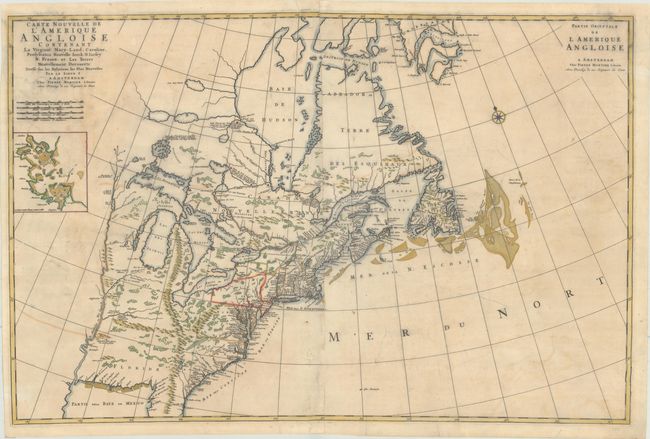
Auction 192, Lot 124
Subject: Colonial Eastern United States & Canada
Mortier, Pierre
Carte Nouvelle de l'Amerique Angloise Contenant la Virginie, Mary-Land, Caroline, Pensylvania Nouvelle Iorck. N: Iarsey N: France, et les Terres Nouvellement Decouerte..., 1700
Size: 35.4 x 23.4 inches (89.9 x 59.4 cm)
Estimate: $1,800 - $2,200
A Map Showing Fascinating Geographic Misconceptions
Sold for: $1,300
Closed on 4/26/2023
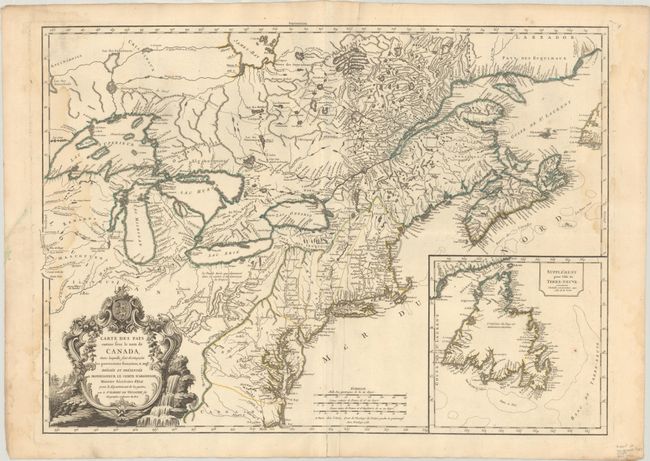
Auction 192, Lot 126
Subject: Colonial Eastern United States & Canada
Le Rouge, George Louis
[Canada et Louisiane], 1755
Size: 19.6 x 24.3 inches (49.8 x 61.7 cm)
Estimate: $1,200 - $1,500
Rare First State of Uncommon French & Indian War Map
Sold for: $750
Closed on 4/26/2023
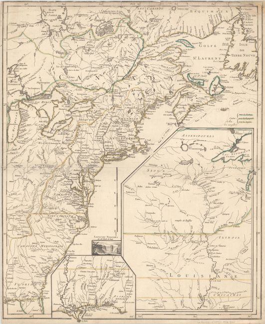
Auction 192, Lot 129
Subject: Colonial Northeastern United States & Canada
Robert de Vaugondy, Didier
Carte des Pays Connus sous le Nom de Canada, dans Laquelle sont Distinguees les Possessions Francoises, & Angl?..., 1755
Size: 26.4 x 18.9 inches (67.1 x 48 cm)
Estimate: $2,300 - $2,750
A Separately Issued, French Political Propaganda Map at the Outset of the French & Indian War
Unsold
Closed on 4/26/2023
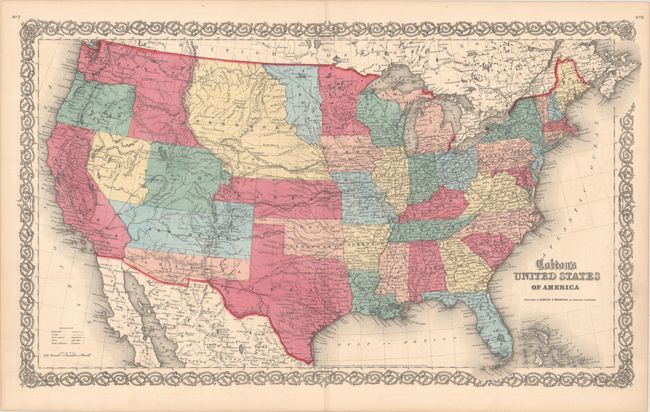
Auction 192, Lot 147
Subject: United States
Johnson & Browning
Colton's United States of America, 1859
Size: 26.4 x 15.7 inches (67.1 x 39.9 cm)
Estimate: $750 - $900
Scarce Map Featuring Colona
Sold for: $850
Closed on 4/26/2023
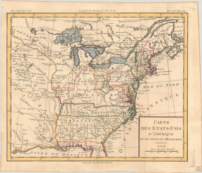
Auction 192, Lot 164
Subject: Eastern United States, Franklin
Brion de la Tour, Louis
Carte des Etats-Unis d'Amerique et du Cours du Mississipi, 1788
Size: 10.7 x 8.8 inches (27.2 x 22.4 cm)
Estimate: $950 - $1,200
One of the Earliest Maps to Feature the State of Franklin
Sold for: $1,100
Closed on 4/26/2023
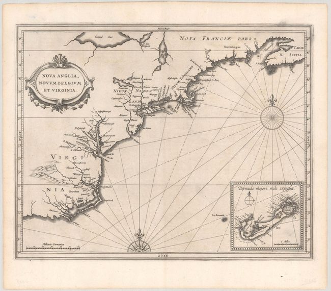
Auction 192, Lot 169
Subject: Colonial New England & Mid-Atlantic United States
Gerritsz/De Laet
Nova Anglia, Novum Belgium et Virginia, 1630
Size: 14 x 11 inches (35.6 x 27.9 cm)
Estimate: $6,000 - $7,500
A Critically Important Map in the Cartographic Evolution of North America
Sold for: $4,500
Closed on 4/26/2023
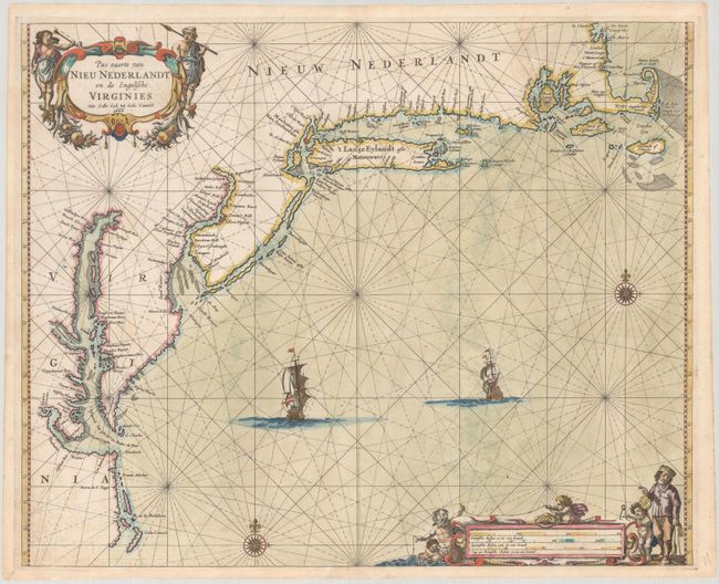
Auction 192, Lot 170
Subject: Colonial New England & Mid-Atlantic United States
Goos, Pieter
Pas Caerte van Nieu Nederlandt en de Engelsche Virginies Van Cabo Cod tot Cabo Canrick, 1666
Size: 20.9 x 16.9 inches (53.1 x 42.9 cm)
Estimate: $7,000 - $8,500
Goos' Gorgeous Chart of the Mid-Atlantic & New England
Unsold
Closed on 4/26/2023
Auction 192, Lot 177
Subject: Colonial Mid-Atlantic United States
Jansson, Jan
Virginia, 1648
Size: 7.6 x 5.8 inches (19.3 x 14.7 cm)
Estimate: $750 - $900
Rare Edition of Atlas Minor Map of Virginia
Sold for: $1,100
Closed on 4/26/2023
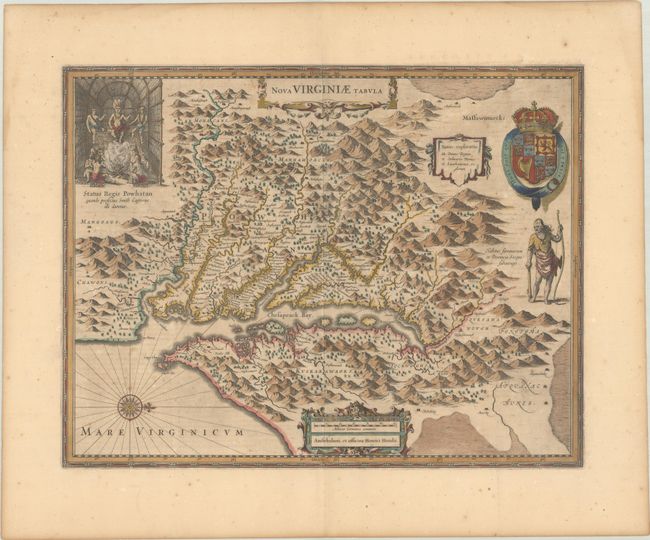
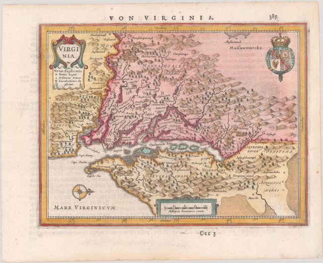
Auction 192, Lot 178
Subject: Colonial Mid-Atlantic United States
Hondius, Henricus
Nova Virginiae Tabula, 1652
Size: 19.4 x 15 inches (49.3 x 38.1 cm)
Estimate: $1,600 - $1,900
One of the Most Important 17th Century Maps of the Chesapeake Bay
Sold for: $1,200
Closed on 4/26/2023
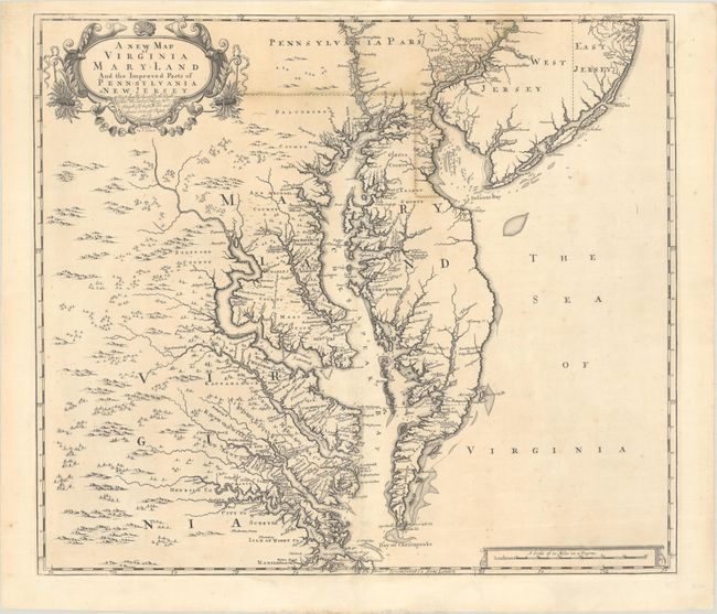
Auction 192, Lot 180
Subject: Colonial Mid-Atlantic United States
Browne/Senex
A New Map of Virginia Mary-Land and the Improved Parts of Pennsylvania & New Jersey..., 1719
Size: 21.8 x 19.1 inches (55.4 x 48.5 cm)
Estimate: $3,500 - $4,250
Map of Chesapeake Bay Based on Landmark Herrman Map
Unsold
Closed on 4/26/2023
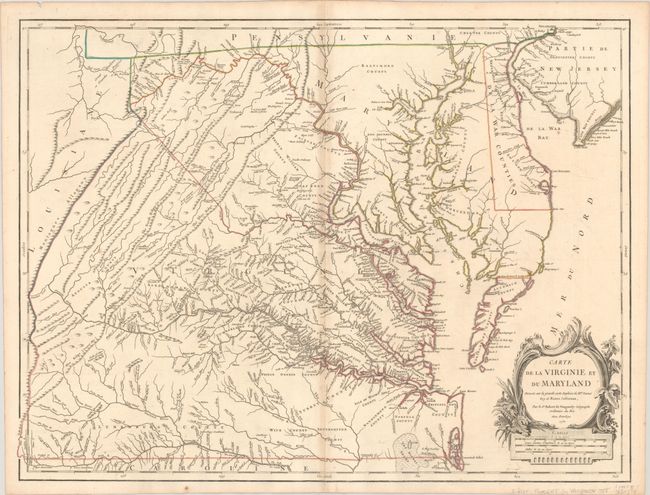
Auction 192, Lot 181
Subject: Colonial Mid-Atlantic United States
Robert de Vaugondy, Didier
Carte de la Virginie et du Maryland Dressee sur la Grande Carte Angloise de Mrs. Josue Fry et Pierre Jefferson, 1755
Size: 25.5 x 19.2 inches (64.8 x 48.8 cm)
Estimate: $2,300 - $2,750
First State of Robert de Vaugondy's Essential Map of Virginia and Maryland
Sold for: $1,700
Closed on 4/26/2023
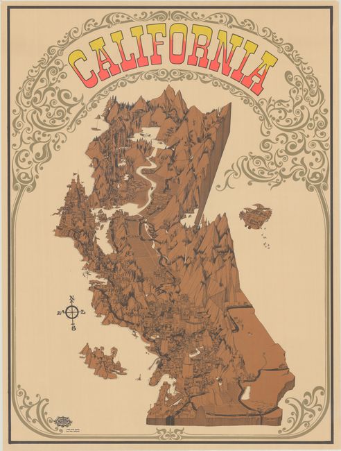
Auction 192, Lot 225
Subject: California
California, 1968
Size: 27.9 x 37.5 inches (70.9 x 95.3 cm)
Estimate: $1,100 - $1,400
A Celebration of the California Music Scene
Sold for: $800
Closed on 4/26/2023
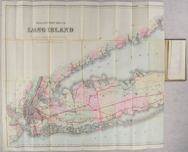
Auction 192, Lot 284
Subject: Long Island, New York
Colton, G.W. & C.B.
Colton's New Map of Long Island, 1886
Size: 64 x 30 inches (162.6 x 76.2 cm)
Estimate: $2,750 - $3,500
Monumental Map of Long Island in Mint Condition
Sold for: $1,400
Closed on 4/26/2023
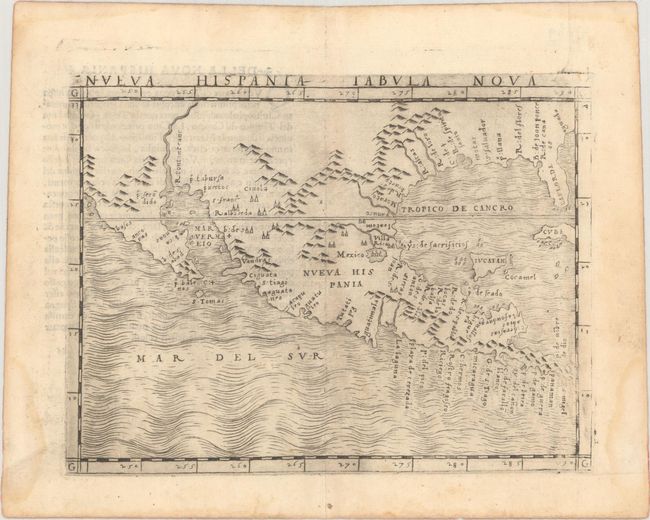
Auction 192, Lot 313
Subject: Southern United States, Mexico & Central America
Gastaldi, Giacomo
Nueva Hispania Tabula Nova, 1548
Size: 6.8 x 5 inches (17.3 x 12.7 cm)
Estimate: $3,250 - $4,000
The First Copperplate Map Devoted to North America
Sold for: $2,400
Closed on 4/26/2023
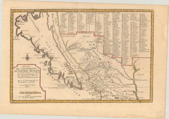
Auction 192, Lot 318
Subject: Southwestern United States & Mexico, California
Fer, Nicolas de
Cette Carte de Californie et du Nouveau Mexique est Tiree de celle qui a ete Envoyee par un Grand d'Espagne pour etre Communiquee a Mrs. de l'Academie Royale des Sciences, 1705
Size: 13.5 x 9 inches (34.3 x 22.9 cm)
Estimate: $1,100 - $1,400
De Fer's Important Map of the Island of California
Sold for: $700
Closed on 4/26/2023
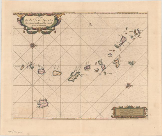
Auction 192, Lot 345
Subject: Lesser Antilles
Roggeveen, Arent
Pascaerte vande Caribes Eylanden, van 't Eylant Granadillos, tot 't Eylant Anguilla, 1675
Size: 20.1 x 16.2 inches (51.1 x 41.1 cm)
Estimate: $3,500 - $4,250
Rare First Edition of Dutch Sea Chart in Full Contemporary Color
Unsold
Closed on 4/26/2023
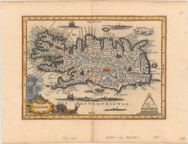
Auction 192, Lot 381
Subject: Iceland
Du Sauzet, Henri
Islande, 1734
Size: 9.9 x 7.2 inches (25.1 x 18.3 cm)
Estimate: $400 - $500
Rare Miniature Map of Iceland
Sold for: $400
Closed on 4/26/2023
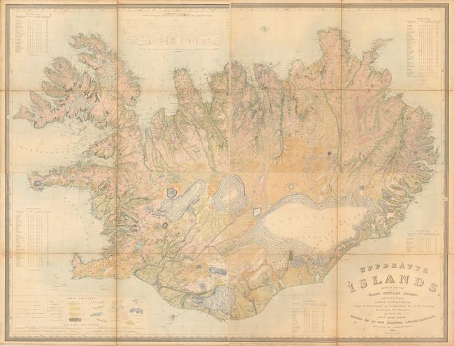
Auction 192, Lot 383
Subject: Iceland
[On 4 Sheets] Uppdrattr Islands..., 1844
Size: 21.8 x 16.5 inches (55.4 x 41.9 cm)
Estimate: $1,500 - $1,800
First Edition of the First Accurate Topographical Map of Iceland
Sold for: $1,100
Closed on 4/26/2023
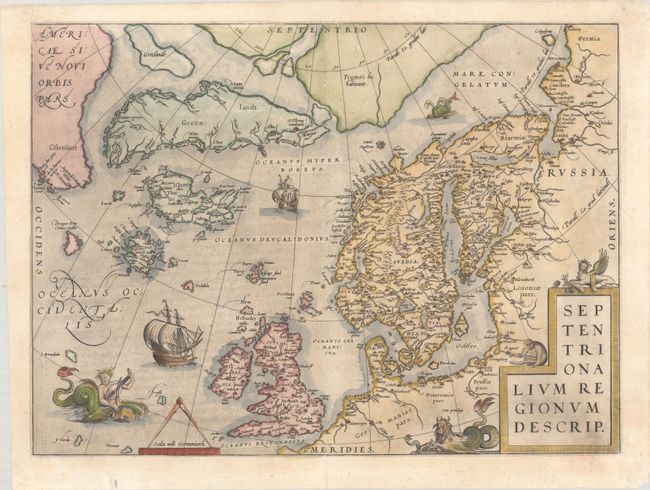
Auction 192, Lot 384
Subject: Arctic & Scandinavia
Ortelius, Abraham
Septentrionalium Regionum Descrip., 1571
Size: 19.4 x 14.2 inches (49.3 x 36.1 cm)
Estimate: $2,300 - $2,750
Early Example of Ortelius' Map of the Arctic with Mythical Islands
Sold for: $2,300
Closed on 4/26/2023
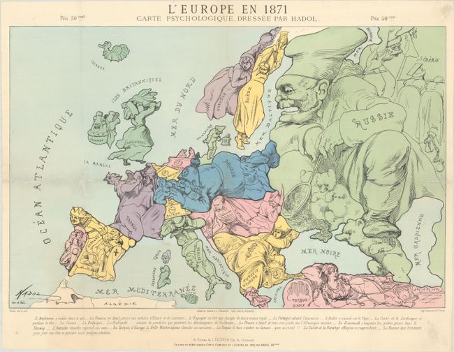
Auction 192, Lot 394
Subject: Europe
L'Europe en 1871 Carte Psychologique, 1871
Size: 19.8 x 12.8 inches (50.3 x 32.5 cm)
Estimate: $1,200 - $1,500
Satirical Anthropomorphic Map Illustrating End of Franco-Prussian War
Sold for: $900
Closed on 4/26/2023
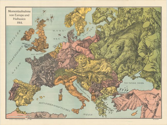
Auction 192, Lot 395
Subject: Europe, World War I
Momentaufnahme von Europa und Halbasien 1914, 1914
Size: 26.8 x 19.1 inches (68.1 x 48.5 cm)
Estimate: $1,200 - $1,500
Rare Propaganda Map from WWI in Support of Central Powers
Sold for: $900
Closed on 4/26/2023
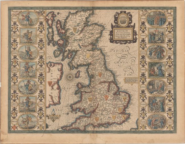
Auction 192, Lot 397
Subject: Britain
Speed, John
Britain as It Was Devided in the Tyme of the Englishe-Saxons Especially During Their Heptarchy, 1676
Size: 20.1 x 15.1 inches (51.1 x 38.4 cm)
Estimate: $2,750 - $3,500
Speed's "Heptarchy" Map Depicting the Saxon Kingdoms
Unsold
Closed on 4/26/2023
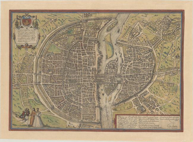
Auction 192, Lot 457
Subject: Paris, France
Braun & Hogenberg
Lutetia Vulgari Nomine Paris, Urbs Galliae Maxima, Sequana Navigabili Flumine Irrigatur…, 1575
Size: 18.9 x 13.3 inches (48 x 33.8 cm)
Estimate: $2,400 - $3,000
Braun & Hogenberg's Plan of Paris in Full Contemporary Color
Sold for: $1,500
Closed on 4/26/2023
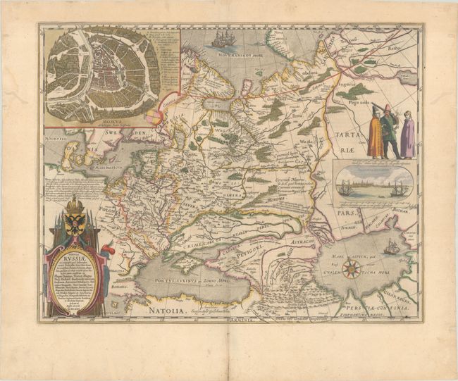
Auction 192, Lot 513
Subject: Russia in Europe
Blaeu, Willem
Tabula Russiae ex Autographo, quod Delineandum Curavit Foedor Filius Tzaris Boris Desumta ... M.DC.XIIII, 1659
Size: 21.6 x 16.8 inches (54.9 x 42.7 cm)
Estimate: $1,800 - $2,100
Blaeu's Decorative Map of Russia
Sold for: $1,200
Closed on 4/26/2023
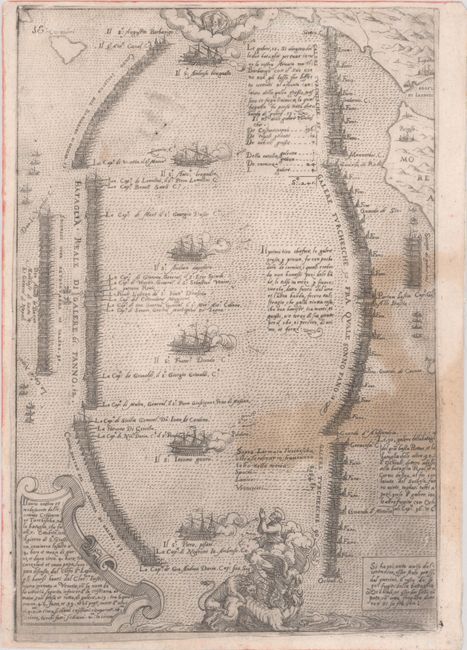
Auction 192, Lot 531
Subject: Gulf of Corinth, Greece
Camocio, Giovanni Francesco
Il Vero Ordine et Modo, Tenuto dalle Armate Cristiana et Turchescha, nella Bataglia, che fu ali. 7. Ottobrio, 1571. Il Giorno di Sa. Giustina..., 1572
Size: 7.1 x 10.4 inches (18 x 26.4 cm)
Estimate: $2,000 - $2,400
Rare Italian Engraving of Battle of Lepanto
Sold for: $1,500
Closed on 4/26/2023
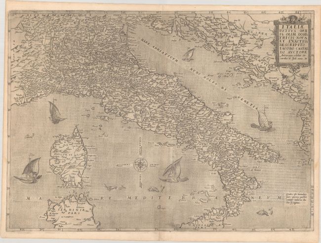
Auction 192, Lot 533
Subject: Italy
Jode, Gerard de
Italiae Totius Orbis olim Domatricis Nova et Exactiss Descriptio Iacobo Castaldo Auctore, 1578
Size: 20.8 x 15 inches (52.8 x 38.1 cm)
Estimate: $3,500 - $4,500
First State of De Jode's Rare and Decorative Map of Italy
Sold for: $2,500
Closed on 4/26/2023
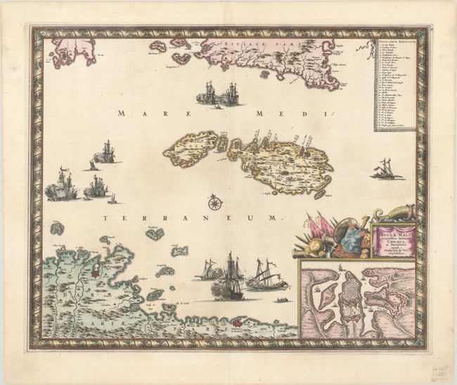
Auction 192, Lot 559
Subject: Malta
Wit, Frederick de
Insula Malta Accuratissime Delineata, Urbibus, et Fortalitiis, 1680
Size: 21.5 x 17.6 inches (54.6 x 44.7 cm)
Estimate: $1,100 - $1,400
One of the Most Decorative 17th Century Maps of Malta
Unsold
Closed on 4/26/2023
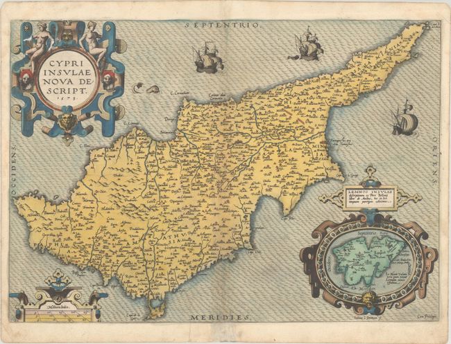
Auction 192, Lot 561
Subject: Cyprus
Ortelius, Abraham
Cypri Insulae Nova Descript., 1573
Size: 19.6 x 13.8 inches (49.8 x 35.1 cm)
Estimate: $1,400 - $1,700
Superb, Decorative Map of Cyprus
Sold for: $1,000
Closed on 4/26/2023
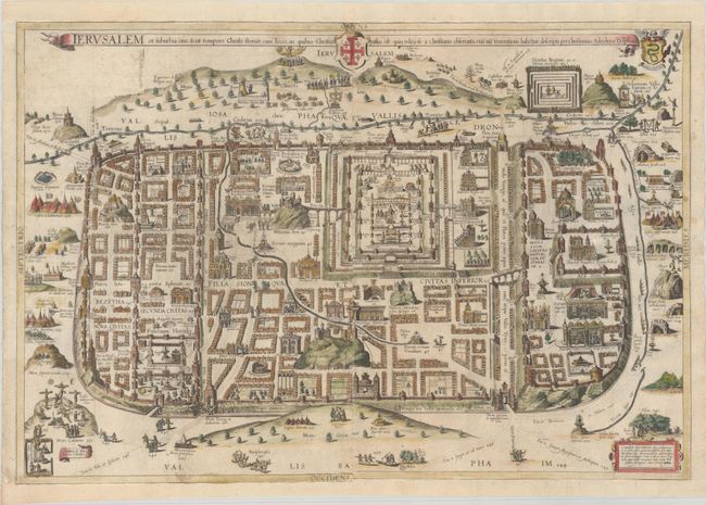
Auction 192, Lot 589
Subject: Jerusalem, Holy Land
Adrichom, Christian van
Ierusalem et Suburbia Eius, Sicut Tempore Christi Floruit, cum Locis, in Quibus Christus Passus Est: quae Religiose a Christianis Observata, Etia nu Venerationi Habetur Descripta, 1682
Size: 29.4 x 19.9 inches (74.7 x 50.5 cm)
Estimate: $1,800 - $2,100
Adrichom's Influential Bird's-Eye Plan of Jerusalem
Sold for: $1,300
Closed on 4/26/2023
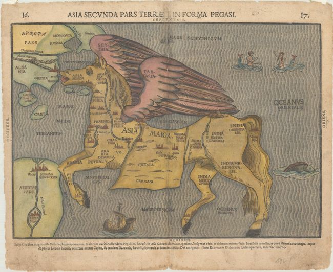
Auction 192, Lot 604
Subject: Asia
Bunting, Heinrich
Asia Secunda Pars Terrae in Forma Pegasi, 1581
Size: 14 x 9.9 inches (35.6 x 25.1 cm)
Estimate: $2,000 - $2,300
Bunting's Rare Map of Asia in the Form of a Pegasus
Sold for: $1,400
Closed on 4/26/2023
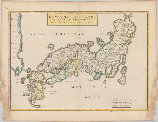
Auction 192, Lot 629
Subject: Japan & Korea
Briet, Philippe
Royaume du Iapon Designe par le Pere Ph: Briet, de la Compagnie de Iesus…, 1658
Size: 20.5 x 14.6 inches (52.1 x 37.1 cm)
Estimate: $1,200 - $1,500
Uncommon French Map of Japan
Unsold
Closed on 4/26/2023
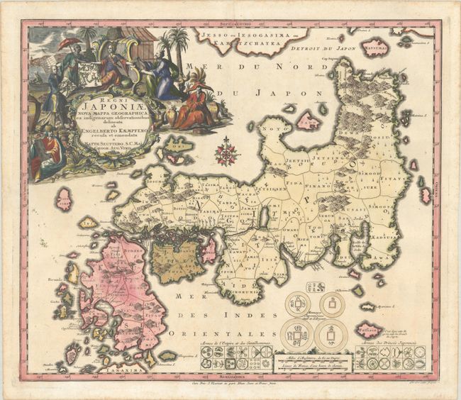
Auction 192, Lot 632
Subject: Japan
Seutter/Lotter
Regni Japoniae Nova Mappa Geographica, ex Indigenarum Observationibus Delineata ab Engelberto Kaempfero Recusa et Emendata, 1740
Size: 22.4 x 19.3 inches (56.9 x 49 cm)
Estimate: $1,500 - $1,800
Seutter's Decorative Map of Japan Based on Kaempfer
Sold for: $1,100
Closed on 4/26/2023
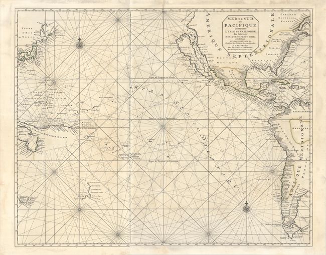
Auction 192, Lot 682
Subject: Pacific Ocean
Covens & Mortier
Mer de Sud, ou Pacifique, Contenant l'Isle de Californe, les Costes de Mexique, du Perou, Chili, et le Destroit de Magellanique &c..., 1721
Size: 29.3 x 23.5 inches (74.4 x 59.7 cm)
Estimate: $2,400 - $3,000
Dramatic Sea Chart Featuring the Island of California
Unsold
Closed on 4/26/2023
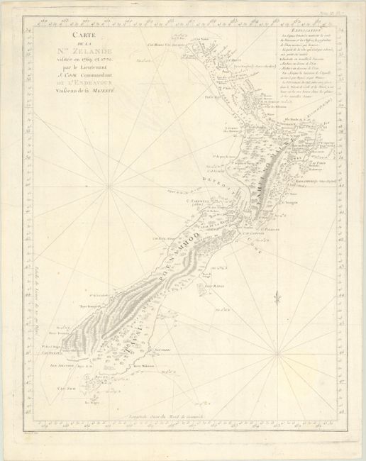
Auction 192, Lot 694
Subject: New Zealand
Cook/Benard
Carte de la Nle. Zelande Visitee en 1769 et 1770. Par le Lieutenant J. Cook Commandant de l'Endeavour Vaisseau de sa Majeste, 1785
Size: 14.8 x 18.9 inches (37.6 x 48 cm)
Estimate: $1,200 - $1,500
Cook's Landmark Map of New Zealand
Sold for: $900
Closed on 4/26/2023
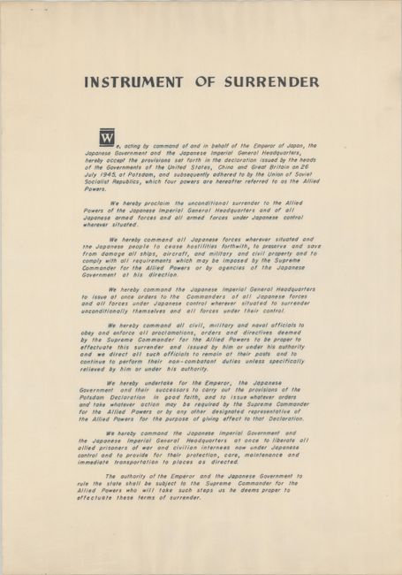
Auction 192, Lot 739
Subject: Document - Japanese Surrender, World War II
[World War II - Japanese Surrender] Japanese Instrument of Surrender - September 2, 1945, 1945
Size: 13.9 x 19.9 inches (35.3 x 50.5 cm)
Estimate: $7,000 - $9,000
Scarce Document of Japan's Surrender Thus Ending World War II
Unsold
Closed on 4/26/2023
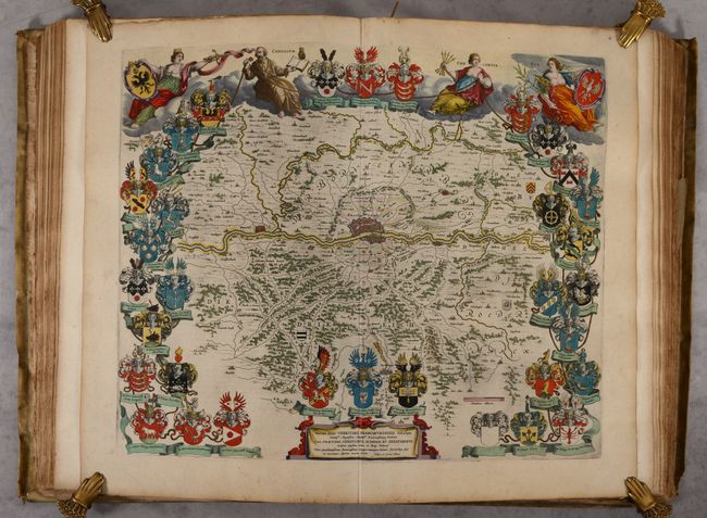
Auction 192, Lot 740
Subject: Atlases
Blaeu, (Family)
Toonneel des Aerdrycx, oft Nieuwe Atlas ... Eerste Deels, 1650
Size: 14.6 x 21.8 inches (37.1 x 55.4 cm)
Estimate: $12,000 - $14,000
Blaeu's Atlas of Germany and the Netherlands with 107 maps in Full Contemporary Color
Unsold
Closed on 4/26/2023
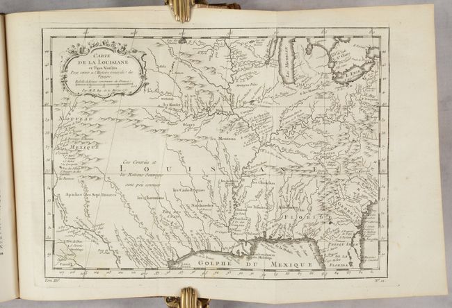
Auction 192, Lot 754
Subject: Exploration & Surveys
Prevost, Anton Francois
Histoire Generale des Voyages, ou Nouvelle Collection de Toutes les Relations de Voyages ... Tome Quatorzieme, 1757
Size: 8 x 10.5 inches (20.3 x 26.7 cm)
Estimate: $2,400 - $3,000
Prevost's Volume on the Americas
Unsold
Closed on 4/26/2023
45 lots