Subject: North Pole
Period: 1611 (published)
Publication: Rerum et Urbis Amstelodamensium Historia
Color: Black & White
Size:
14 x 10.5 inches
35.6 x 26.7 cm
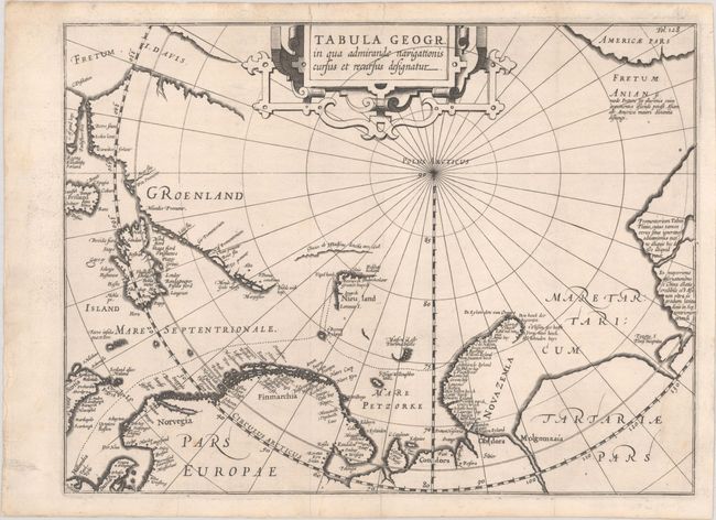
Scarce map of the North Pole and Arctic regions showing recent discoveries, including the voyages of Jan Willem Barentsz to find a Northeast passage to the East Indies, and of Henry Hudson, who was searching for a Northwest passage. A dotted line delineates the track of Barentsz' third voyage from 1596-97, in which he discovered Bear Island (t'Beeren Eyland) and Spitsbergen (Nieu Land). A portion of coastline near Greenland is noted as ice discovered by Hudson in 1608. The mythical island of Frisland appears at left and S. Hugo Willoughbes lant is shown in the Barentsz Sea. Hugh Willoughby was an English explorer who was also searching for a Northeast passage in 1553. In his journal, he noted sighting islands in the Barentsz Sea, which were later named after him. Willoughby did not survive his voyage and his journal was recovered by the English several years later. Also of interest is the early appearance of Fretum Anian separating Americae pars from the Asian continent. Embellished with a large strapwork title cartouche. Published by Jodocus Hondius.
References: Shirley (BL Atlases) G.PONT-1a #4.
Condition: A
Sharp impression on a bright sheet with the watermark of an armorial with a bend and crown. Issued folding and professionally backed in archival paper to repair some short, marginal tears. One light spot in map, else fine.