Subject: United States
Period: 1859 (dated)
Publication: Atlas of the World
Color: Hand Color
Size:
26.4 x 15.7 inches
67.1 x 39.9 cm
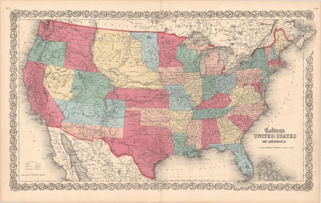
This scarce map of the United States is from the rare Colton atlas that was published by Johnson and Browning, circa 1860. It is filled with provisional western territorial boundaries, including the rarely seen Colona in the region that would eventually become Colorado. Other western territorial boundaries include Dakota Territory between Minnesota and the Missouri River, and Nebraska taking in the rest of the region up to the Rocky Mountains. Kanzas Territory borders Utah and New Mexico in the west. Washington Territory wraps around Oregon to include present-day Idaho. A proposed Nevada Territory is shown by color and mentioned below the word Utah, with its eastern border along the 114th meridian down to Preuss L., then following the Virgin River to the New Mexican boundary. The proposed Arizona Territory is shown in the southern part of New Mexico. Several exploration routes are shown, including those of Fremont, Marcy, and Kearney, and several emigration roads are delineated. A very desirable map of the United States and the only American atlas to show Colona.
References:
Condition: A
Vibrant colors on a clean sheet. There are short centerfold separations at top and bottom that have been closed on verso with archival materials.