Showing Featured Lots(remove filter)
Showing results for:Auction 172
Catalog Archive
58 lots
Page 1 of 2
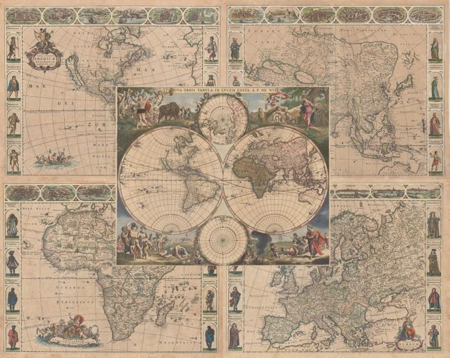
Auction 172, Lot 11
Subject: World & Continents
Wit, Frederick de
[Lot of 5] Nova Orbis Tabula, in Lucem Edita [and] Nova Totius Americae Descriptio [and] Asiae Nova Descriptio [and] Nova Africa Descriptio [and] Nova Europae Descriptio, 1660-70
Size: See Description
Estimate: $11,000 - $13,000
A Stunning Set of Carte-a-Figures Maps
Sold for: $6,500
Closed on 4/17/2019
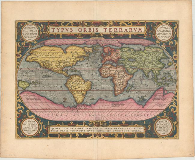
Auction 172, Lot 15
Subject: World
Ortelius, Abraham
Typus Orbis Terrarum, 1587
Size: 19.2 x 14 inches (48.8 x 35.6 cm)
Estimate: $6,000 - $7,500
Ortelius' Third World Map in an Oval Projection
Sold for: $4,500
Closed on 4/17/2019
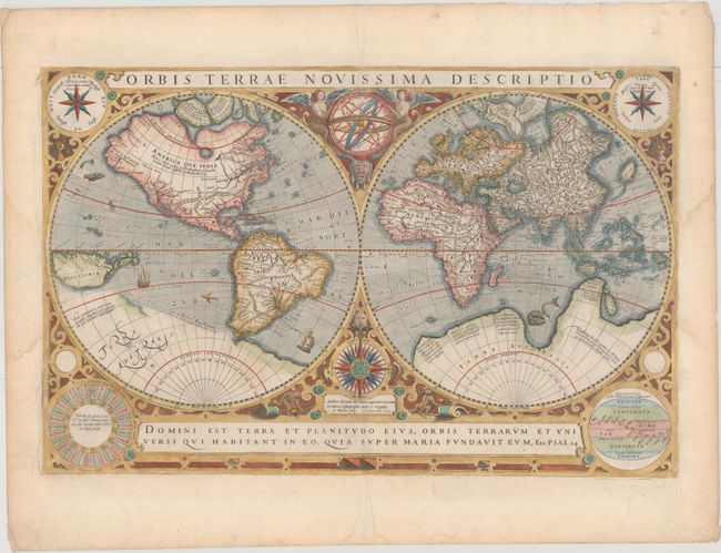
Auction 172, Lot 16
Subject: World
Hondius/Le Clerc
Orbis Terrae Novissima Descriptio, 1633
Size: 19.9 x 12.9 inches (50.5 x 32.8 cm)
Estimate: $5,500 - $6,500
Le Clerc's Decorative World Map Engraved by Hondius
Unsold
Closed on 4/17/2019
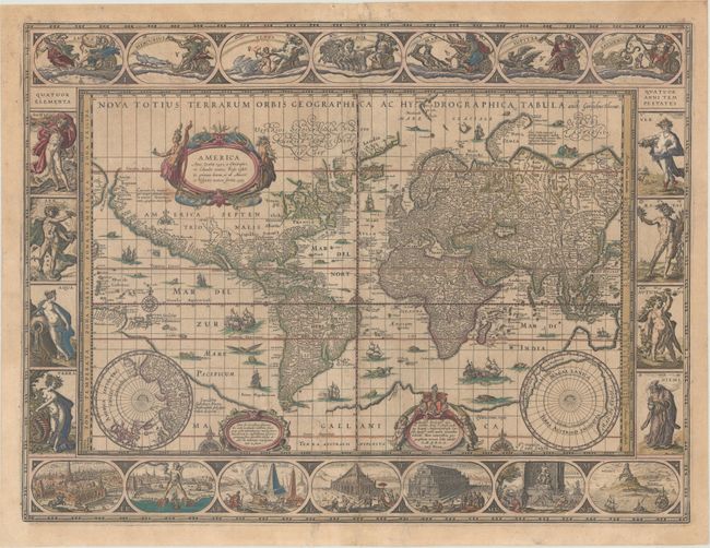
Auction 172, Lot 17
Subject: World
Blaeu, Willem
Nova Totius Terrarum Orbis Geographica ac Hydrographica Tabula, 1635
Size: 21.4 x 16.1 inches (54.4 x 40.9 cm)
Estimate: $9,500 - $11,000
Blaeu's Magnificent Carte-a-Figures World Map in Full Contemporary Color
Sold for: $7,000
Closed on 4/17/2019
Auction 172, Lot 18
Subject: World
Camoens, Luis de
[Untitled - World], 1639
Size: 15.4 x 7.8 inches (39.1 x 19.8 cm)
Estimate: $4,750 - $6,000
A Scarce Spanish World Map
Unsold
Closed on 4/17/2019
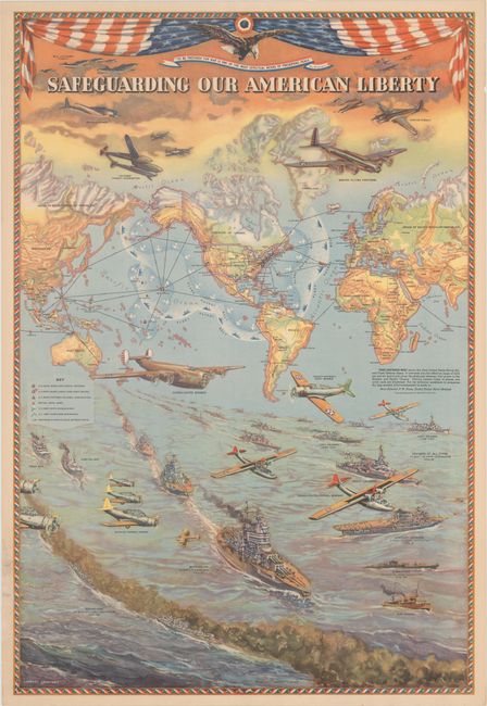
Auction 172, Lot 35
Subject: World, World War II
Hammond, C. S.
Safeguarding Our American Liberty, 1941
Size: 21 x 30.9 inches (53.3 x 78.5 cm)
Estimate: $1,900 - $2,200
Superb WWII Map Demonstrating the United States' Military Reach
Sold for: $3,750
Closed on 4/17/2019
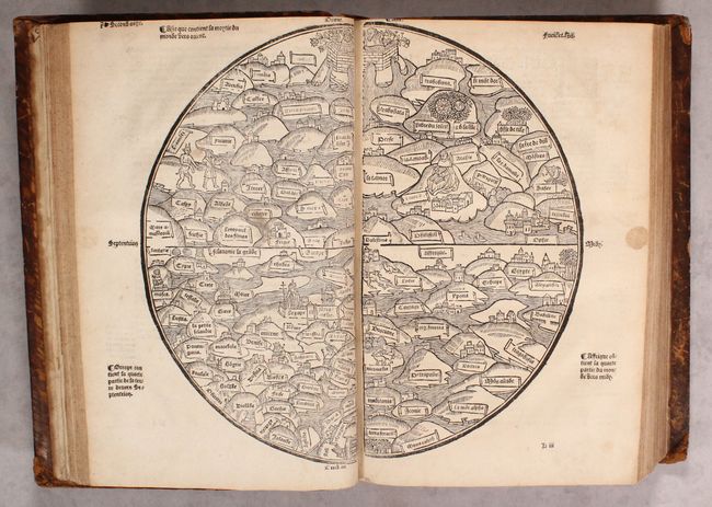
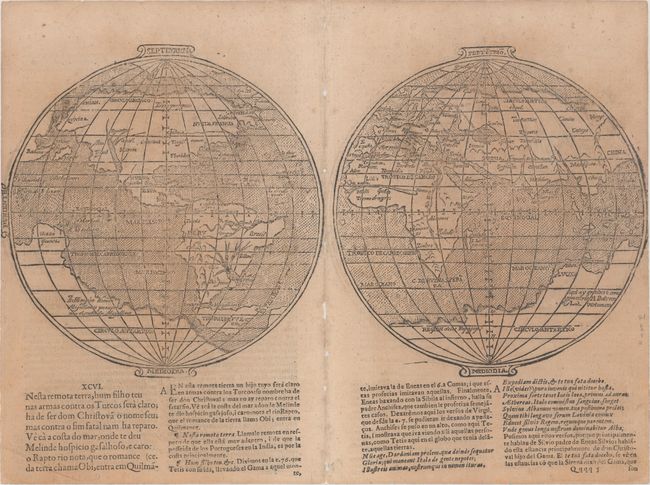
Auction 172, Lot 37
Subject: Ancient World & Holy Land
[Ancient World & Palestine Maps in book] La Mer des Histoires..., 1543
Size: 13.5 x 9.3 inches (34.3 x 23.6 cm)
Estimate: $28,000 - $35,000
Rare Medieval Maps of the World and Palestine
Unsold
Closed on 4/17/2019
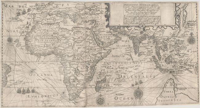
Auction 172, Lot 39
Subject: Eastern Hemisphere
Bry, Theodore de
Descriptio Hydrographica Accommodata ad Battavorum Navagatione in Javam Insulam Indiae Orientalis... / Eygentliche und Ausfuhrliche Mappa de Orientallischen Indien Darinen auch mit Puntten Angezeichnet di hin und wider um Reise der Hollander..., 1599
Size: 26.1 x 14.1 inches (66.3 x 35.8 cm)
Estimate: $7,000 - $8,500
Elaborate Map Depicting Cornelis de Houtman First Voyage to the East Indies
Sold for: $3,800
Closed on 4/17/2019
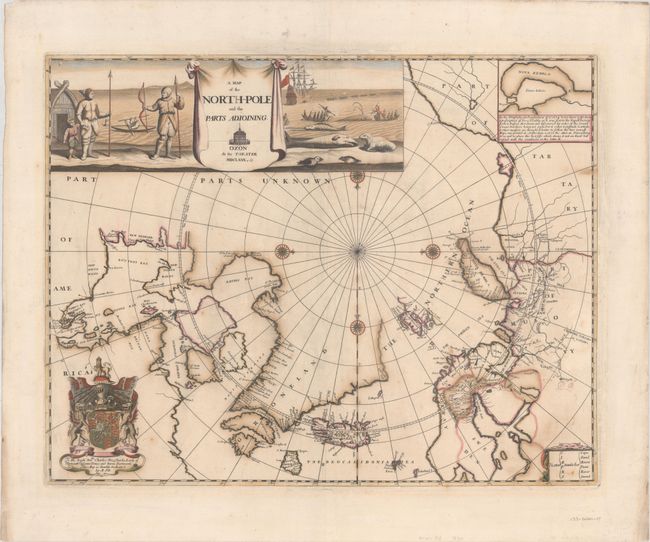
Auction 172, Lot 42
Subject: North Pole
Pitt, Moses
A Map of the North-Pole and the Parts Adioining, 1680
Size: 23.1 x 18 inches (58.7 x 45.7 cm)
Estimate: $3,000 - $3,750
Beautiful English Map of the North Pole
Sold for: $2,200
Closed on 4/17/2019
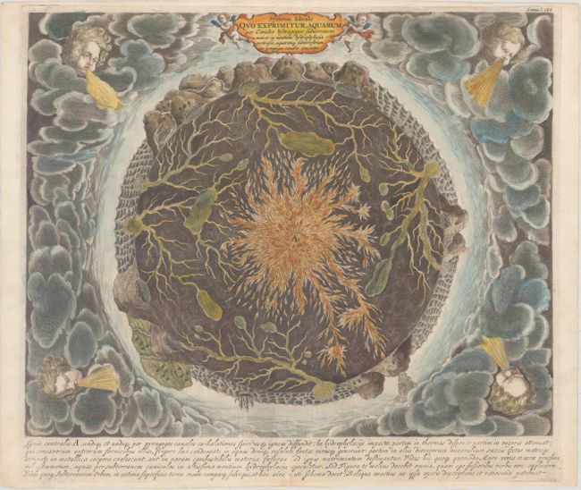
Auction 172, Lot 50
Subject: Cartographic Miscellany, Earth
Kircher, Athanasius
Systema Ideale quo Exprimitur, Aquarum per Canales Hydragogos Subterraneos ex Mari et in Montium Hydrophylacia..., 1682
Size: 16 x 12.9 inches (40.6 x 32.8 cm)
Estimate: $1,500 - $1,800
Fascinating Cross-Section of the Earth
Sold for: $1,000
Closed on 4/17/2019
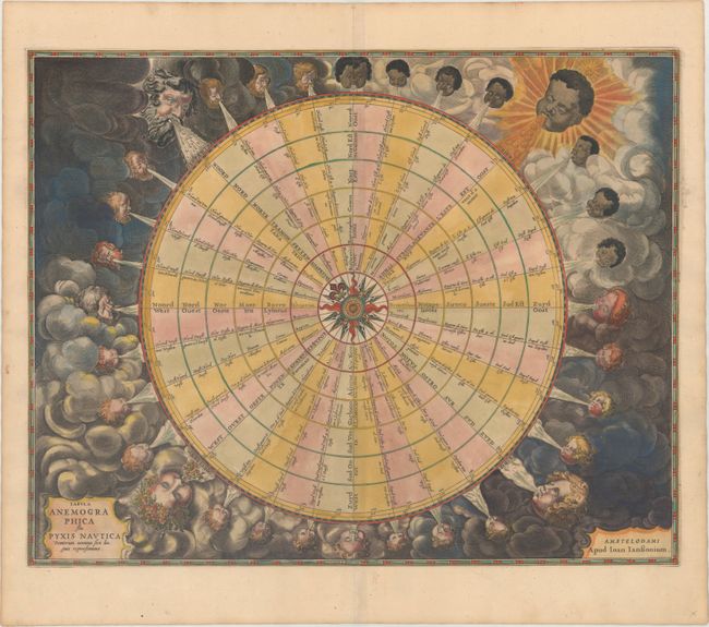
Auction 172, Lot 51
Subject: Cartographic Miscellany
Jansson, Jan
Tabula Anemographica seu Pyxis Nautica Ventorum Nomina Sex Linguis Repraesentans, 1684
Size: 21.4 x 17 inches (54.4 x 43.2 cm)
Estimate: $2,000 - $2,500
Dramatic 32-Point Wind Rose
Sold for: $1,200
Closed on 4/17/2019
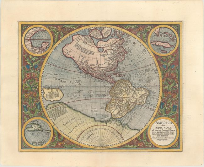
Auction 172, Lot 60
Subject: Western Hemisphere - America
Mercator/Hondius
America sive India Nova, ad Magnae Gerardi Mercatoris aui Universalis Imitationem, in Compendium Redacta, 1619
Size: 18.3 x 14.5 inches (46.5 x 36.8 cm)
Estimate: $3,500 - $4,500
Mercator's Foundation Map for the Americas
Sold for: $2,500
Closed on 4/17/2019
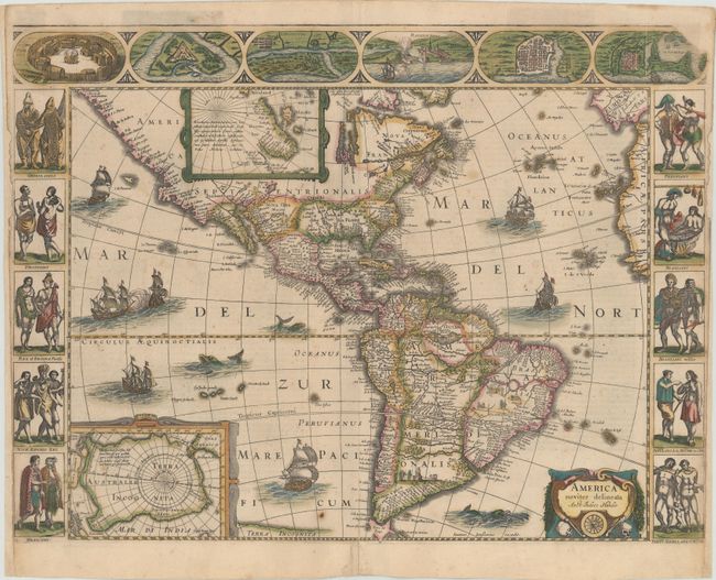
Auction 172, Lot 61
Subject: Western Hemisphere - America
Hondius/Jansson
America Noviter Delineata, 1645
Size: 21.9 x 16.3 inches (55.6 x 41.4 cm)
Estimate: $7,000 - $8,500
Jansson's Rare Carte-a-Figures Map of the Americas in Full Original Color
Unsold
Closed on 4/17/2019
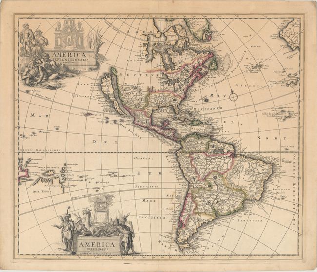
Auction 172, Lot 63
Subject: Western Hemisphere - America
Schenk, Pierre
America Septentrionalis. Novissima / America Meridionalis. Accuratissima, 1695
Size: 22.1 x 18.8 inches (56.1 x 47.8 cm)
Estimate: $1,600 - $1,900
Uncommon Map Featuring Two Figurative Title Cartouches
Unsold
Closed on 4/17/2019
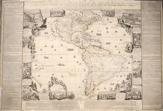
Auction 172, Lot 65
Subject: Western Hemisphere - America
Fer, Nicolas de
L'Amerique, Divisee Selon Letendue des ses Principales Parties, et dont les Points Principaux sont Placez sur les Observations de Messieurs de l'Academie Royale des Sciences..., 1705
Size: 46.6 x 35.9 inches (118.4 x 91.2 cm)
Estimate: $20,000 - $25,000
De Fer's Monumental Wall Map of the Americas and the "Original Beaver Map"
Sold for: $13,500
Closed on 4/17/2019
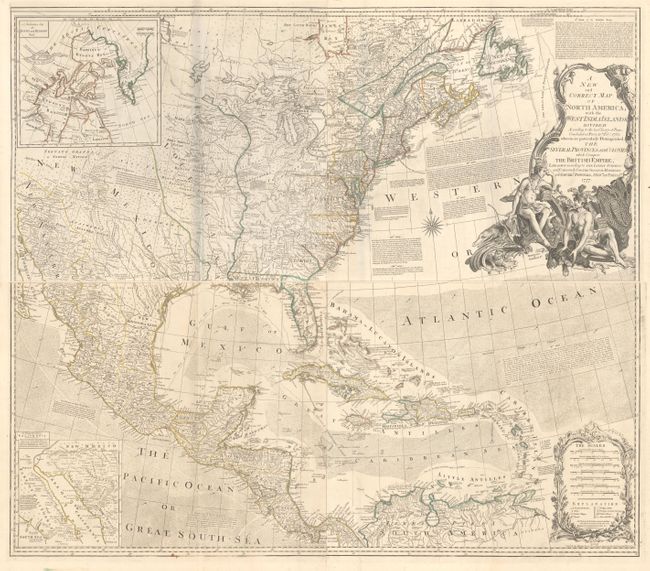
Auction 172, Lot 79
Subject: Colonial North America
Bowen & Gibson
[On 4 Sheets] A New and Correct Map of North America, with the West India Islands. Divided According to the Last Treaty of Peace..., 1777
Size: 45.8 x 20 inches (116.3 x 50.8 cm)
Estimate: $4,000 - $5,000
Bowen & Gibson's Large and Influential Map of North America
Sold for: $2,700
Closed on 4/17/2019
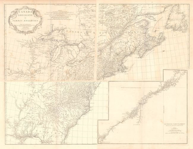
Auction 172, Lot 96
Subject: Colonial Eastern United States & Canada
Anville, Jean Baptiste Bourguignon d'
[On 4 Sheets] Canada Louisiane et Terres Angloises, 1755
Size: 22 x 18.8 inches (55.9 x 47.8 cm)
Estimate: $1,400 - $1,700
D'Anville's Spectacular Map of Eastern Seaboard
Unsold
Closed on 4/17/2019
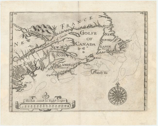
Auction 172, Lot 102
Subject: Colonial Northeastern United States & Canada
Alexander, William (Sir)
[Untitled - Northeastern United States & Canada], 1625
Size: 13.5 x 9.8 inches (34.3 x 24.9 cm)
Estimate: $6,000 - $7,500
The First Map to Name New Scotland
Unsold
Closed on 4/17/2019
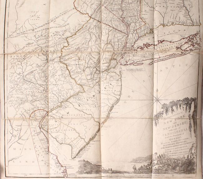
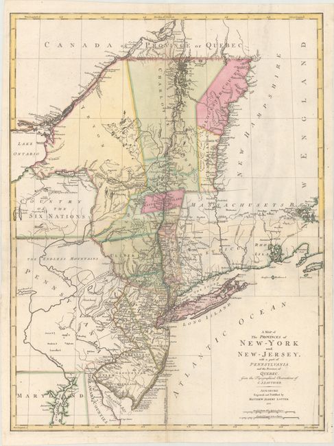
Auction 172, Lot 106
Subject: Colonial Northeastern United States & Quebec
Holland/Pownal
The Provinces of New York, and New Jersey; with Part of Pensilvania, and the Province of Quebec..., 1776
Size: 21.5 x 53.3 inches (54.6 x 135.4 cm)
Estimate: $5,000 - $6,500
Thomas Jefferys' Important Revolutionary War Period Map
Unsold
Closed on 4/17/2019
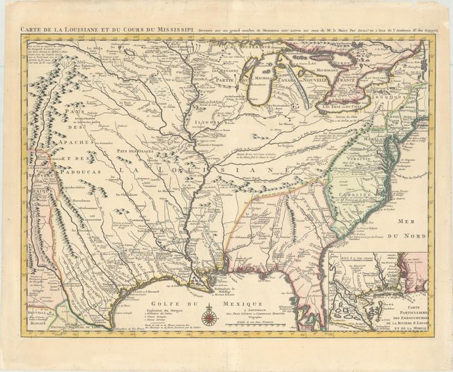
Auction 172, Lot 119
Subject: Colonial Eastern United States, Louisiana Territory
Delisle/Covens & Mortier
Carte de la Louisiane et du Cours du Mississipi Dressee sur un Grand Nombre de Memoires Entr'autres sur ceux de Mr. le Maire, 1730
Size: 23.4 x 17.3 inches (59.4 x 43.9 cm)
Estimate: $1,800 - $2,200
Delisle's Influential Map of the Louisiana Territory
Unsold
Closed on 4/17/2019
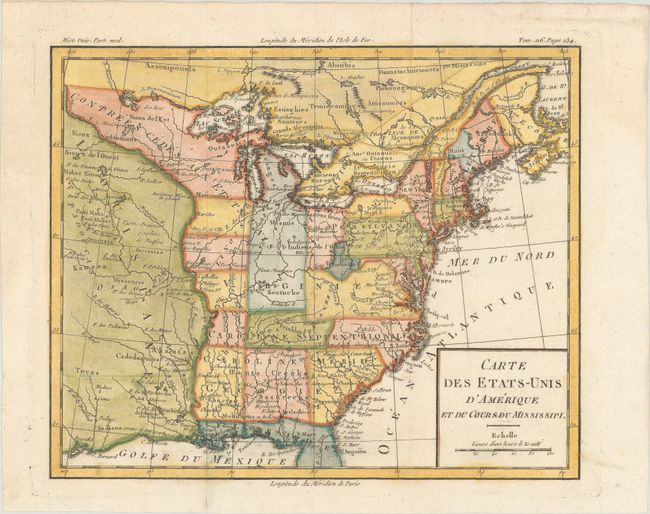
Auction 172, Lot 122
Subject: Eastern United States, Franklin
Brion de la Tour, Louis
Carte des Etats-Unis d'Amerique et du Cours du Mississipi, 1788
Size: 10.6 x 8.6 inches (26.9 x 21.8 cm)
Estimate: $800 - $950
One of the Earliest Maps to Feature the State of Franklin
Sold for: $3,750
Closed on 4/17/2019
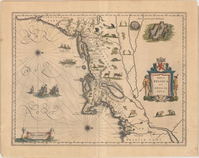
Auction 172, Lot 129
Subject: Colonial New England & Mid-Atlantic United States
Blaeu, Willem
Nova Belgica et Anglia Nova, 1635
Size: 19.9 x 15.3 inches (50.5 x 38.9 cm)
Estimate: $2,200 - $2,500
Important Map of Colonial New England and the Mid-Atlantic in Contemporary Color
Sold for: $1,600
Closed on 4/17/2019
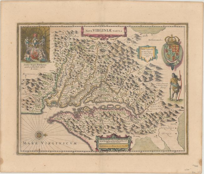
Auction 172, Lot 137
Subject: Colonial Mid-Atlantic United States
Hondius, Henricus
Nova Virginiae Tabula, 1638
Size: 19.4 x 14.9 inches (49.3 x 37.8 cm)
Estimate: $1,800 - $2,200
One of the Most Important 17th Century Maps of the Chesapeake Bay in Full Contemporary Color
Sold for: $1,300
Closed on 4/17/2019
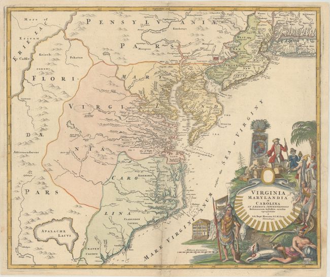
Auction 172, Lot 139
Subject: Colonial Mid-Atlantic United States
Homann, Johann Baptist
Virginia Marylandia et Carolina in America Septentrionali Britannorum Industria Excultae Repraesentatae, 1730
Size: 22.8 x 19.1 inches (57.9 x 48.5 cm)
Estimate: $1,600 - $2,000
Map Created to Promote German Immigration to the New World
Unsold
Closed on 4/17/2019
Auction 172, Lot 142
Subject: Colonial Mid-Atlantic United States
Lotter, Mathias Albrecht
A Map of the Provinces of New-York and New-Jersey, with a part of Pennsylvania and the Province of Quebec, from the Topographical Observations of C. J. Sauthier, 1777
Size: 22.3 x 29.5 inches (56.6 x 74.9 cm)
Estimate: $1,900 - $2,200
Important Revolutionary War Map
Sold for: $1,600
Closed on 4/17/2019
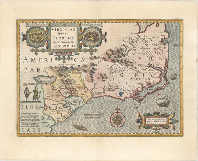
Auction 172, Lot 147
Subject: Colonial Southeast United States
Hondius, Jodocus
Virginiae Item et Floridae Americae Provinciarum, Nova Descriptio, 1619
Size: 19.3 x 13.6 inches (49 x 34.5 cm)
Estimate: $2,000 - $2,400
A Seminal Map of the Southeast and Early American Cartography
Sold for: $1,500
Closed on 4/17/2019
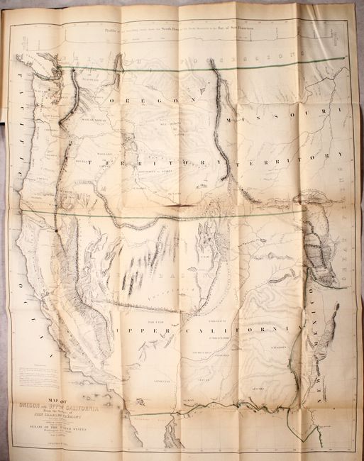
Auction 172, Lot 168
Subject: Western United States
Fremont/Preuss
Map of Oregon and Upper California from the Surveys of John Charles Fremont and Other Authorities [bound in] Geographical Memoir upon Upper California..., 1848
Size: 26.5 x 33 inches (67.3 x 83.8 cm)
Estimate: $1,600 - $1,900
Fremont's Map of the American West
Sold for: $850
Closed on 4/17/2019
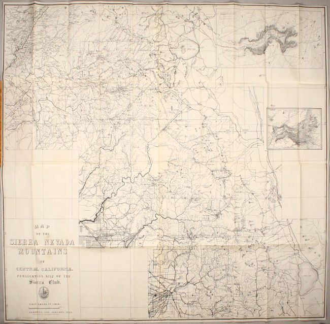
Auction 172, Lot 197
Subject: Central California, Yosemite
Map of the Sierra Nevada Mountains of Central California. Publication No. 12 of the Sierra Club, 1896
Size: 39.1 x 37.6 inches (99.3 x 95.5 cm)
Estimate: $700 - $850
A Scarce Sierra Club Map
Sold for: $500
Closed on 4/17/2019
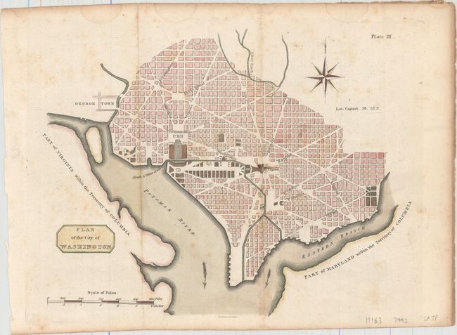
Auction 172, Lot 209
Subject: Washington, D.C.
Plan of the City of Washington, 1805
Size: 10.6 x 8.3 inches (26.9 x 21.1 cm)
Estimate: $1,200 - $1,500
Rare Scottish Plan of Washington
Unsold
Closed on 4/17/2019
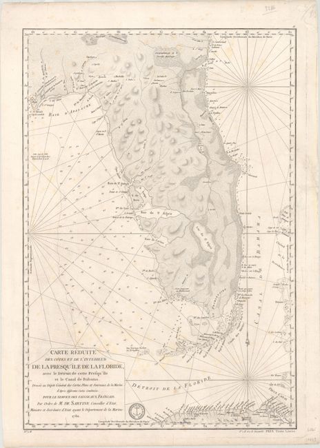
Auction 172, Lot 213
Subject: Florida
Sartine
Carte Reduite des Cotes et de l'Interieur de la Presqu'ile de la Floride, avec le Detroit de Cette Presqu'ile et le Canal de Bahama..., 1780
Size: 15.7 x 22.9 inches (39.9 x 58.2 cm)
Estimate: $2,000 - $2,300
Map of Florida Peninsula Intended for Use by French Navy During American Revolution
Sold for: $1,100
Closed on 4/17/2019
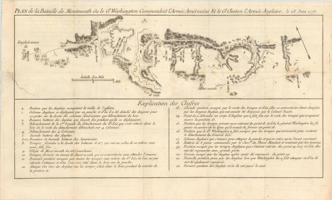
Auction 172, Lot 242
Subject: Monmouth, New Jersey
Plan de la Bataille de Montmouth ou le Gl. Washington Commandait l'Armee Americaine et le Gl. Clinton l'Armee Anglaise, le 28 Juin 1778, 1782
Size: 15.4 x 8.1 inches (39.1 x 20.6 cm)
Estimate: $1,200 - $1,500
An Important Battle Plan of the American Revolution
Unsold
Closed on 4/17/2019
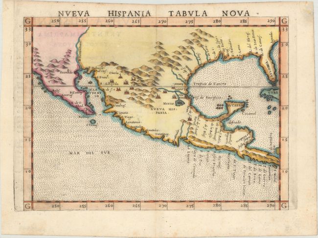
Auction 172, Lot 282
Subject: Southern United States & Mexico
Ruscelli, Girolamo
Nueva Hispania Tabula Nova, 1574
Size: 9.6 x 7.1 inches (24.4 x 18 cm)
Estimate: $1,300 - $1,600
A Foundation Map for the American Southwest
Sold for: $650
Closed on 4/17/2019
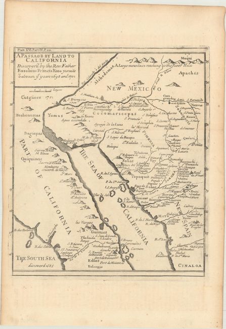
Auction 172, Lot 286
Subject: Southwestern United States & Mexico
Kino, Eusebio Francisco, SJ
A Passage by Land to California Discover'd by the Rev. Father Eusebius Francis Kino Jesuite Between ye Years 1698 and 1701 [with text], 1721
Size: 8 x 9.1 inches (20.3 x 23.1 cm)
Estimate: $950 - $1,200
Father Kino's Important Map of California
Sold for: $700
Closed on 4/17/2019
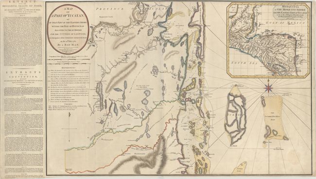
Auction 172, Lot 303
Subject: Belize
Faden, William
A Map of a Part of Yucatan, or of That Part of the Eastern Shore Within the Bay of Honduras..., 1787
Size: 31.4 x 20.7 inches (79.8 x 52.6 cm)
Estimate: $1,000 - $1,500
Rare Foundation Map for Belize Outlining the British Logging Industry
Sold for: $3,250
Closed on 4/17/2019
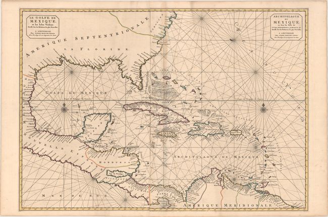
Auction 172, Lot 305
Subject: Gulf of Mexico & Caribbean
Mortier, Pierre
Le Golfe de Mexique, et les Isles Voisine. Dresse sur les Relations les Plus Nouvelles / Archipelague du Mexique, ou sont les Isles de Cuba, Espagnola, Jamaica, &c. Dresse sur les Relations les Plus Nouvelles, 1700
Size: 33.4 x 23.5 inches (84.8 x 59.7 cm)
Estimate: $1,500 - $1,800
Stunning, Short-Lived Chart of the Gulf of Mexico
Sold for: $900
Closed on 4/17/2019
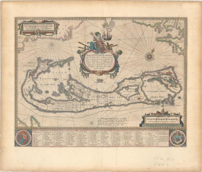
Auction 172, Lot 372
Subject: Bermuda
Blaeu, Willem
Mappa Aestivarum Insularum, Alias Barmudas Dictarum, ad Ostia Mexicani Aestuary..., 1642
Size: 21 x 15.9 inches (53.3 x 40.4 cm)
Estimate: $1,700 - $2,000
Map of Bermuda Based on Richard Norwood's Famous Survey
Unsold
Closed on 4/17/2019
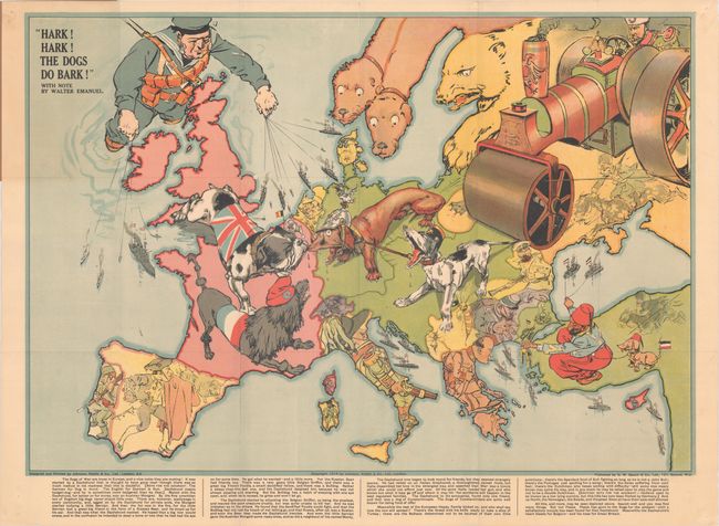
Auction 172, Lot 384
Subject: Europe, WWI
Bacon, G. W. & Company
Hark! Hark! The Dogs Do Bark!, 1914
Size: 27.6 x 19 inches (70.1 x 48.3 cm)
Estimate: $1,600 - $2,000
Rare Political Caricature Pocket Map Depicting European Countries as Dogs
Sold for: $1,000
Closed on 4/17/2019
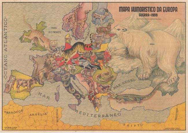
Auction 172, Lot 385
Subject: Europe, WWII
Mapa Humoristico da Europa Guerra - 1939, 1939
Size: 25.2 x 17.8 inches (64 x 45.2 cm)
Estimate: $2,750 - $3,750
Very Rare Zoomorphic Map of Europe During WWII
Sold for: $2,000
Closed on 4/17/2019
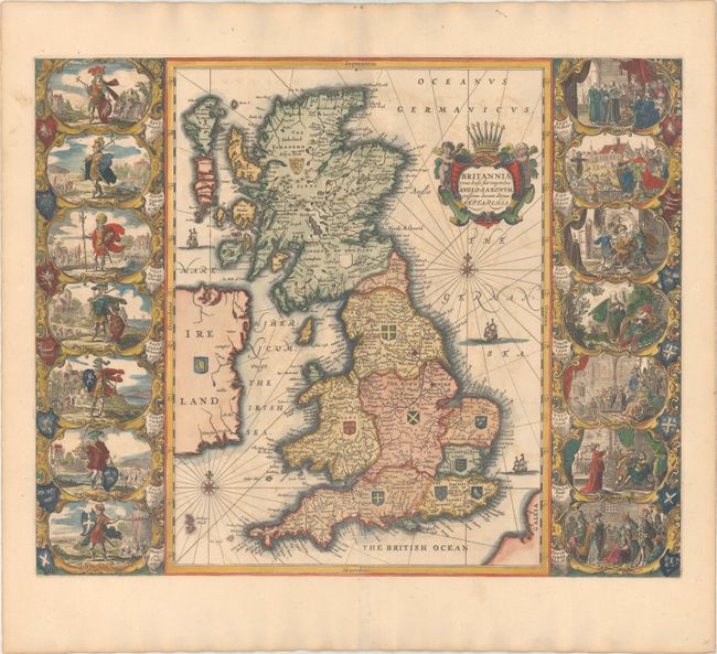
Auction 172, Lot 387
Subject: Britain
Jansson, Jan
Britannia Prout Divisa suit Temporibus Anglo-Saxonum, Praesertim Durante Illorum Heptarchia, 1684
Size: 20.5 x 16.4 inches (52.1 x 41.7 cm)
Estimate: $2,000 - $2,400
Jansson's Splendid Heptarchy Map
Sold for: $1,000
Closed on 4/17/2019
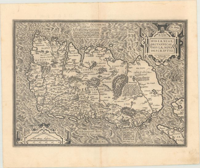
Auction 172, Lot 406
Subject: Ireland
Ortelius, Abraham
Eryn. Hiberniae, Britannicae Insulae, Nova Descriptio. Irlandt, 1595
Size: 19 x 13.9 inches (48.3 x 35.3 cm)
Estimate: $1,500 - $1,800
Ortelius' First Map of Ireland
Sold for: $1,000
Closed on 4/17/2019
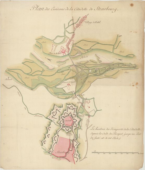
Auction 172, Lot 451
Subject: Strasbourg, France
Anon.
Plan des Environs de la Citadelle de Strasbourg, 1770
Size: 13.3 x 14.8 inches (33.8 x 37.6 cm)
Estimate: $1,200 - $1,500
Stunning Manuscript Map Showing the Fortifications of Strasbourg
Unsold
Closed on 4/17/2019
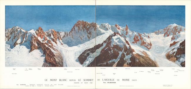
Auction 172, Lot 454
Subject: French Alps
Description Geometrique Detaillee des Alpes Francaises - Annexe du Tome Second, 1921
Size: 21.8 x 26.3 inches (55.4 x 66.8 cm)
Estimate: $2,300 - $2,750
Rare and Beautiful Panoramic Views of the French Alps
Sold for: $1,700
Closed on 4/17/2019
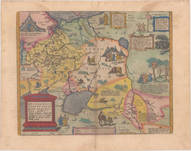
Auction 172, Lot 504
Subject: Russia, Eastern Europe & Central Asia
Ortelius, Abraham
Russiae, Moscoviae et Tartariae Descriptio. Auctore Antonio Ienkensono Anglo..., 1579
Size: 17.2 x 13.6 inches (43.7 x 34.5 cm)
Estimate: $1,900 - $2,200
Ortelius' Map of Russia with a Vignette of Ivan the Terrible
Unsold
Closed on 4/17/2019
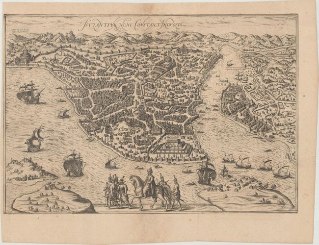
Auction 172, Lot 583
Subject: Istanbul, Turkey
Braun & Hogenberg
Byzantium, nunc Constantinopolis, 1657
Size: 18.9 x 12.9 inches (48 x 32.8 cm)
Estimate: $1,500 - $1,800
Jansson's Publication of Braun and Hogenberg's Superb Bird's-Eye View During the Golden Age of the Ottoman Empire
Sold for: $750
Closed on 4/17/2019
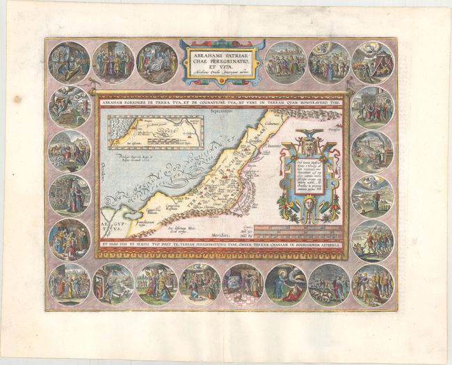
Auction 172, Lot 587
Subject: Holy Land
Ortelius, Abraham
Abrahami Patriarchae Peregrinatio, et Vita, 1586
Size: 17.8 x 13.8 inches (45.2 x 35.1 cm)
Estimate: $1,900 - $2,200
Elaborate Map of the Holy Land, Illustrating the Life of Abraham
Sold for: $1,400
Closed on 4/17/2019
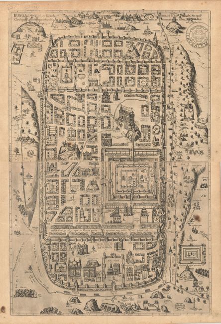
Auction 172, Lot 603
Subject: Jerusalem, Holy Land
Braun & Hogenberg
[2 Sheets] Ierusalem, et Suburbia eius, Sicut Tempore Christi Floruit..., 1575
Size: 18.9 x 14.4 inches (48 x 36.6 cm)
Estimate: $1,600 - $1,900
Braun & Hogenberg's Two-Sheet Plan of Jerusalem
Sold for: $1,200
Closed on 4/17/2019
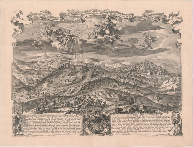
Auction 172, Lot 608
Subject: Bethlehem, Holy Land
Wahrer Abriss der Stadt Bethlehem..., 1752
Size: 20.5 x 15.3 inches (52.1 x 38.9 cm)
Estimate: $1,200 - $1,500
Magnificent Panoramic View of Bethlehem with Scenes from the Christmas Story
Unsold
Closed on 4/17/2019
Auction 172, Lot 634
Subject: China
Nieuhoff, Johann
L'Ambassade de la Compagnie Orientale des Provinces Unies vers l'Empereur de la Chine, ou Grand Cam de Tartarie..., 1665
Size: 13.4 x 8.8 inches (34 x 22.4 cm)
Estimate: $3,250 - $4,000
Nieuhoff's Important Description of the Chinese Empire
Unsold
Closed on 4/17/2019
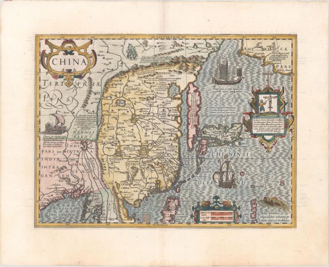
Auction 172, Lot 643
Subject: China, Korea & Japan
Mercator/Hondius
China, 1619
Size: 18.3 x 13.5 inches (46.5 x 34.3 cm)
Estimate: $2,750 - $3,500
Hondius' Map of China, Korea, and Japan
Unsold
Closed on 4/17/2019
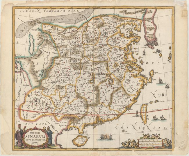
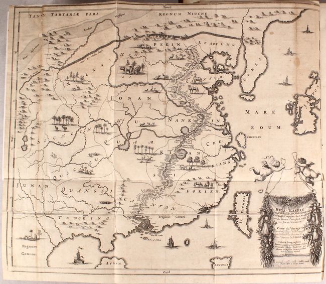
Auction 172, Lot 644
Subject: China & Korea
Jansson, Jan
Imperii Sinarum Nova Descriptio, 1660
Size: 20.6 x 18.5 inches (52.3 x 47 cm)
Estimate: $1,400 - $1,700
Map of China Based on Father Martino Martini's Travels
Sold for: $1,000
Closed on 4/17/2019
58 lots
Page 1 of 2