Subject: Jerusalem, Holy Land
Period: 1575 (circa)
Publication: Civitates Orbis Terrarum, Vol. IV
Color: Black & White
Size:
18.9 x 14.4 inches
48 x 36.6 cm
Braun & Hogenberg's Civitates Orbis Terrarum or "Cities of the World" was published between 1572 and 1617. Within the six volumes, 531 towns and cities were depicted on 363 plates, providing the reader with the pleasures of travel without the attendant discomforts. Braun wrote in the preface to the third book, "What could be more pleasant than, in one's own home far from all danger, to gaze in these books at the universal form of the earth . . . adorned with the splendor of cities and fortresses and, by looking at pictures and reading the texts accompanying them, to acquire knowledge which could scarcely be had but by long and difficult journeys?" Braun and Hogenberg incorporated an astonishing wealth of information into each scene beyond the city layout and important buildings. The plates provide an impression of the economy and prominent occupations, and illustrate local costumes, manners and customs.
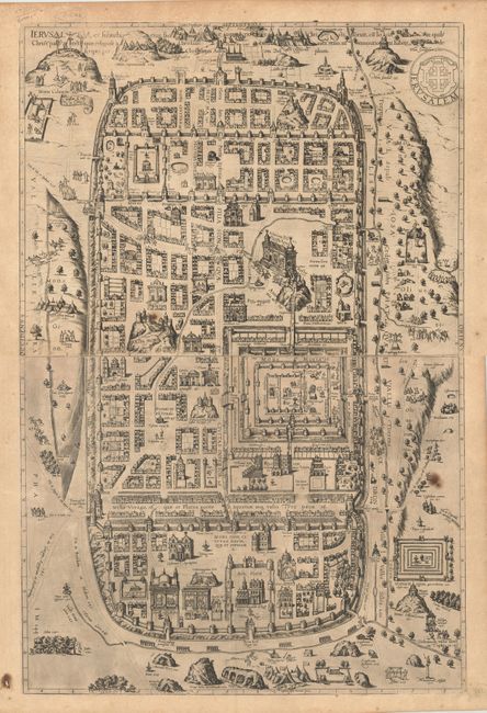
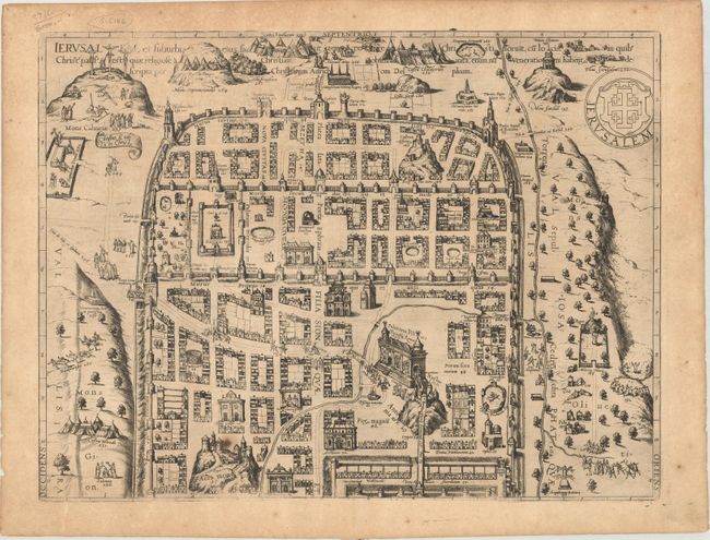
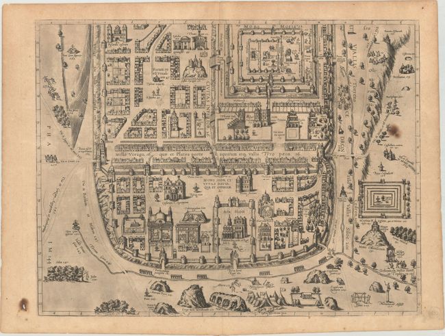
This impressive plan of the city of Jerusalem at the time of Christ was based on the model of Christian Adrichom (1584). It became the definitive layout of Jerusalem until the archaeological discoveries in the nineteenth century. The detailed plan includes over 250 important biblical sites, including the fourteen Stations of the Cross. Printed on two separate sheets, professionally joined. This work was one of only three double-sheet plans that appeared in the Civitatis Orbis Terrarum. Latin text on verso.
References: Laor #1041; Nebenzahl (HL) plt. 33; Fussel pp. 344-45.
Condition: B+
Dark impression with light toning and minor soiling. There are three small, dark spots caused by irregular particles that found their way into the paper-making process: in the top sheet at bottom left; in the bottom sheet at right; and in the blank margin of the bottom sheet at bottom left, with the particle coming loose from the paper and resulting in a small hole. Please note that the first image is a composite image - the map is in two separate sheets.