Subject: Belize
Period: 1787 (dated)
Publication:
Color: Hand Color
Size:
31.4 x 20.7 inches
79.8 x 52.6 cm
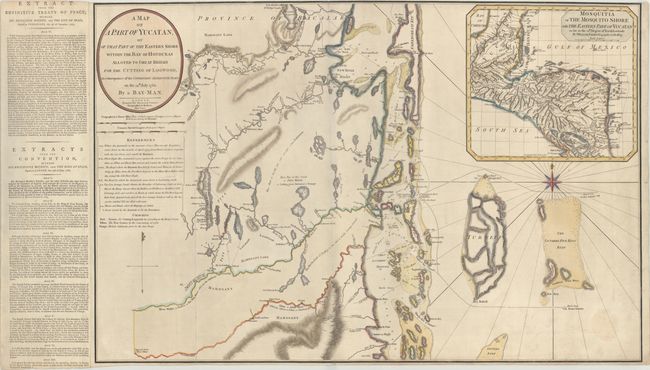
This impressive, large map depicts the coastline of northern Belize from St. Philip's Castle (on Lake Bacalar in present-day Mexico) to Hopkins and Commerce Bight. There is excellent detail of the islands along the coast with navigational details, including soundings, rocks, shoals, and several tracks. There is also great inland detail of the various rivers and lagoons close to the shore, but no settlements are illustrated. At top right is an inset of Central America from Belize to Nicaragua. This map was created to show the region in which the British were given rights by the Spanish, who controlled the area, to cut logwood. At left is an extract from the Treaty of Versailles in 1783 outlining Britain's rights to cut logwood. As the logwood industry had declined by 1783, Britain signed an additional treaty with Spain in 1786 to allow the British to cut all other wood, including the lucrative Mahogany trees, as outlined in the second extract. The extracts were printed on a separate sheet and pasted onto the map, as issued.
As this map was separately issued, it is very rare. We have only found two other examples listed for sale in the last 40 years, and none within the last 20 years.
References: Kapp (MCC-106) #76.
Condition: B+
Issued folding with light soiling and archival repairs to a 2" fold separation at bottom left, a 1" tear below the title, and some minor edge tears. Trimmed to the neatline at top.