Showing Featured Lots(remove filter)
Showing results for:Auction 149
Catalog Archive
61 lots
Page 1 of 2
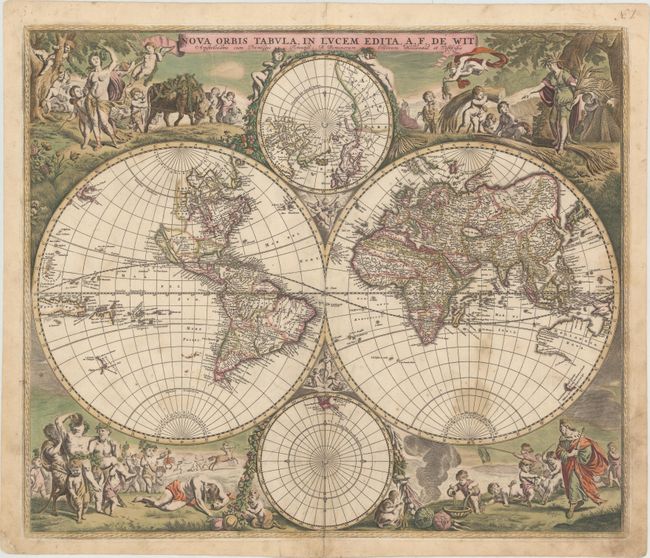
Auction 149, Lot 9
Subject: World & Continents
Wit, Frederick de
[Lot of 5] Nova Orbis Tabula, in Lucem Edita [and] Novissima et Accuratissima Septentrionalis ac Meridionalis Americae Descriptio... [and] Totius Africae... [and] Accuratissima Totius Asiae Tabula... [and] Nova et Accurate ... Europae Descriptio, 1690
Size: 22.7 x 19.2 inches (57.7 x 48.8 cm)
Estimate: $8,000 - $9,500
Matching Set in Full Original Color
Sold for: $5,000
Closed on 5/21/2014
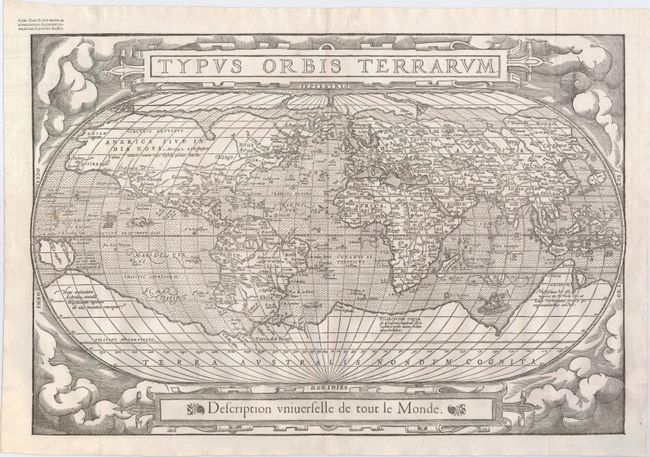
Auction 149, Lot 10
Subject: World
Belleforest, Francois
Typus Orbis Terrarum, 1575
Size: 19.5 x 13.2 inches (49.5 x 33.5 cm)
Estimate: $4,750 - $6,000
Scarce Woodcut Version of Ortelius’ World Map
Unsold
Closed on 5/21/2014
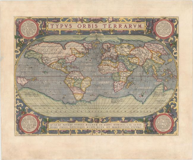
Auction 149, Lot 12
Subject: World
Ortelius, Abraham
Typus Orbis Terrarum, 1587
Size: 19.1 x 14 inches (48.5 x 35.6 cm)
Estimate: $7,500 - $9,000
Ortelius' Third World Map in an Oval Projection
Unsold
Closed on 5/21/2014
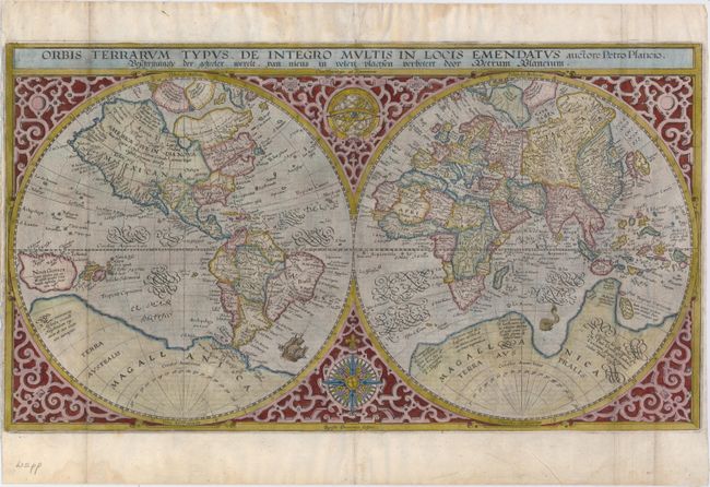
Auction 149, Lot 13
Subject: World
Plancius, Petrus
Orbis Terrarum Typus de Integro Multis in Locis Emendatus, 1592
Size: 20.1 x 11.2 inches (51.1 x 28.4 cm)
Estimate: $3,500 - $4,500
Rare Second State
Sold for: $2,750
Closed on 5/21/2014
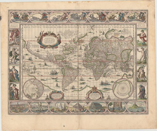
Auction 149, Lot 15
Subject: World
Blaeu, Willem
Nova Totius Terrarum Orbis Geographica ac Hydrographica Tabula, 1635
Size: 21.4 x 16.1 inches (54.4 x 40.9 cm)
Estimate: $14,000 - $16,000
Blaeu's Magnificent Carte-a-Figures World Map in Full Original Color
Sold for: $9,000
Closed on 5/21/2014
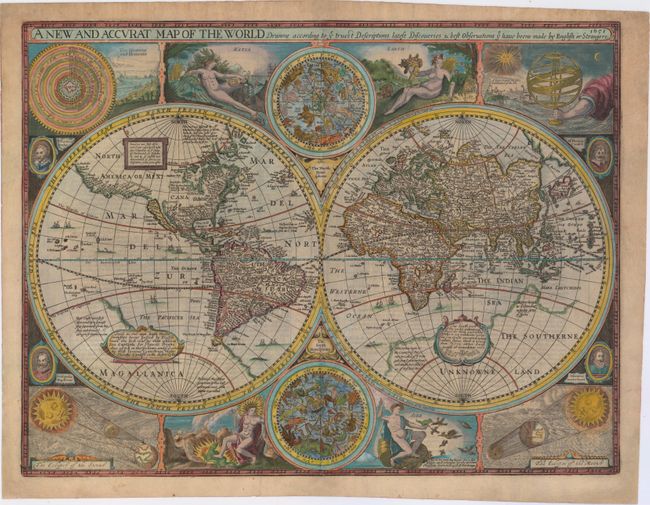
Auction 149, Lot 16
Subject: World
Speed, John
A New and Accurat Map of the World Drawne According to ye Truest Descriptions Latest Discoveries & Best Observations yt have beene Made by English or Strangers, 1651
Size: 20.5 x 15.8 inches (52.1 x 40.1 cm)
Estimate: $14,000 - $16,000
Speed's Double-Hemisphere World Map
Sold for: $13,500
Closed on 5/21/2014
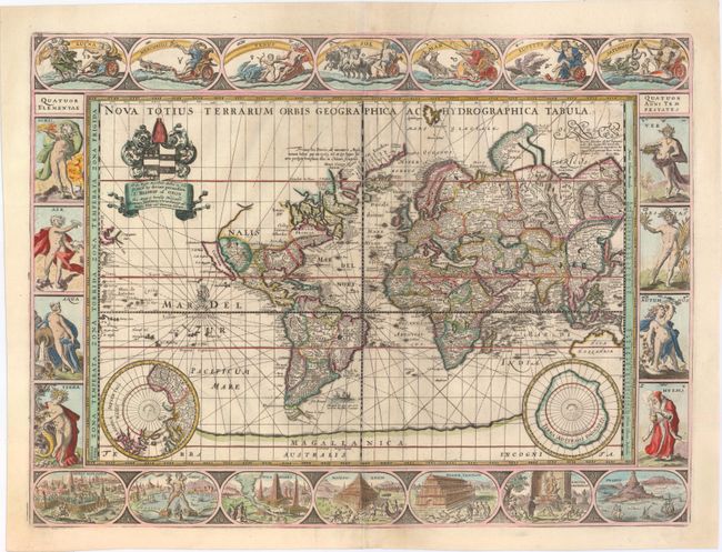
Auction 149, Lot 17
Subject: World
Pitt, Moses
Nova Totius Terrarum Orbis Geographica ac Hydrographica Tabula, 1680
Size: 21 x 15.7 inches (53.3 x 39.9 cm)
Estimate: $11,000 - $13,000
Pitt's Rare Carte-a-Figures Map
Sold for: $7,000
Closed on 5/21/2014
Auction 149, Lot 18
Subject: World
Valck, Gerard and Leonard
Orbis Terrarum Nova et Accurata Tabula, 1700
Size: 22.4 x 19.1 inches (56.9 x 48.5 cm)
Estimate: $5,500 - $6,500
Baroque-Style Double-Hemisphere Map Depicting the Four Seasons
Unsold
Closed on 5/21/2014
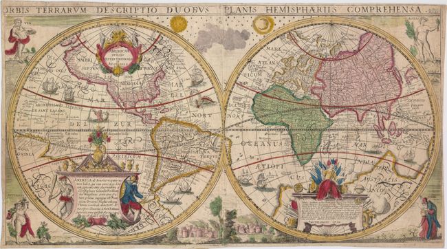
Auction 149, Lot 28
Subject: World
Anon.
Orbis Terrarum Descriptio Duobus Planis Hemisphaeriis Comprehensa, 1750
Size: 21.9 x 12 inches (55.6 x 30.5 cm)
Estimate: $3,750 - $4,500
Scarce, Decorative Double-Hemisphere World Map Based on Geelkercken and Hondius
Unsold
Closed on 5/21/2014
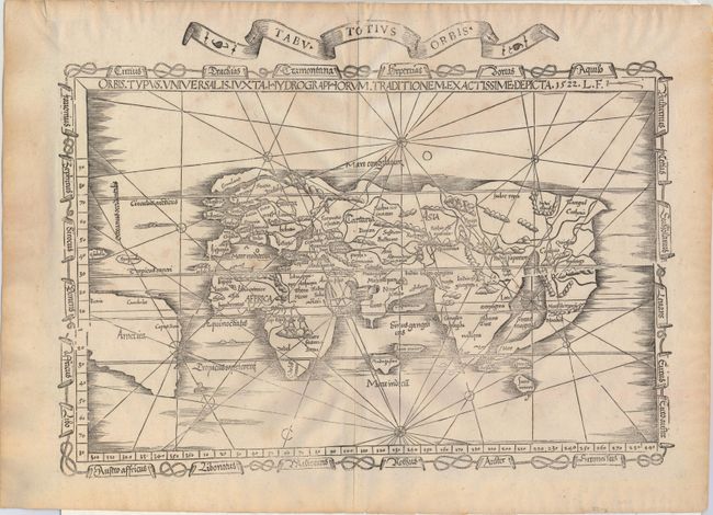
Auction 149, Lot 36
Subject: Ancient World
Fries, Lorenz
Orbis Typus Universalis Iuxta Hydrographorum Traditionem Exactissime Depicta, 1522
Size: 19 x 13.9 inches (48.3 x 35.3 cm)
Estimate: $6,000 - $7,500
One of the First Ptolemaic Maps to Name America
Sold for: $5,000
Closed on 5/21/2014
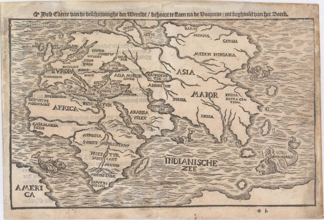
Auction 149, Lot 37
Subject: Ancient World
Bunting, Heinrich
Dese Caerte van de Beschrijvinghe der Wereldt..., 1596
Size: 10 x 6.1 inches (25.4 x 15.5 cm)
Estimate: $2,000 - $2,400
Scarce Map of the Ancient World Naming America
Sold for: $1,700
Closed on 5/21/2014
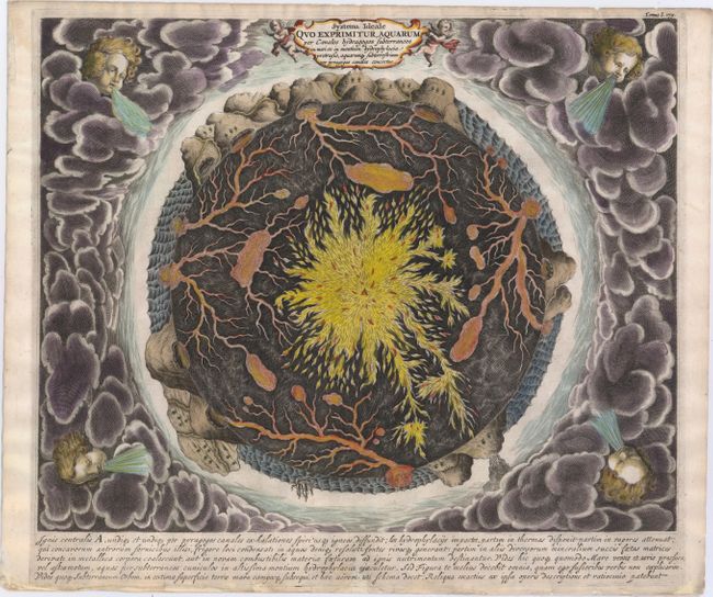
Auction 149, Lot 53
Subject: Cartographic Miscellany, Earth
Kircher, Athanasius
Systema Ideale Quo Exprimitur, Aquarum per Canales Hydragogos Subterraneos ex Mari et in Montium Hydrophylacia Protrusio, Aquarumq. Subterrestrium per Pyragogos Canales Concoctus, 1682
Size: 16.3 x 13.1 inches (41.4 x 33.3 cm)
Estimate: $1,600 - $1,800
Fascinating Cross-Section of the Earth
Unsold
Closed on 5/21/2014
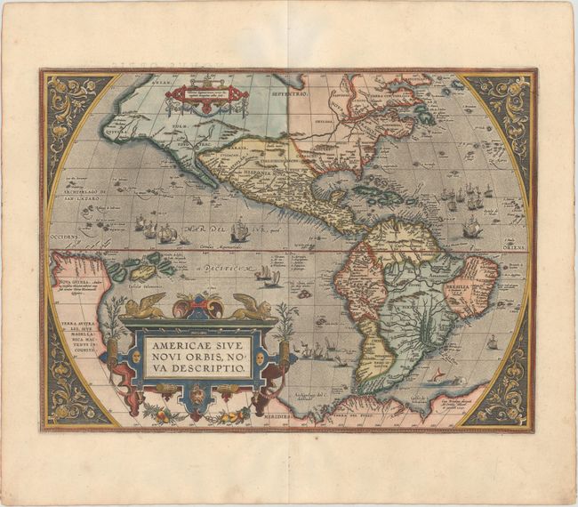
Auction 149, Lot 57
Subject: Western Hemisphere - America
Ortelius, Abraham
Americae Sive Novi Orbis, Nova Descriptio, 1587
Size: 19.1 x 14 inches (48.5 x 35.6 cm)
Estimate: $6,000 - $7,500
Ortelius' Influential Map of the New World
Sold for: $4,500
Closed on 5/21/2014
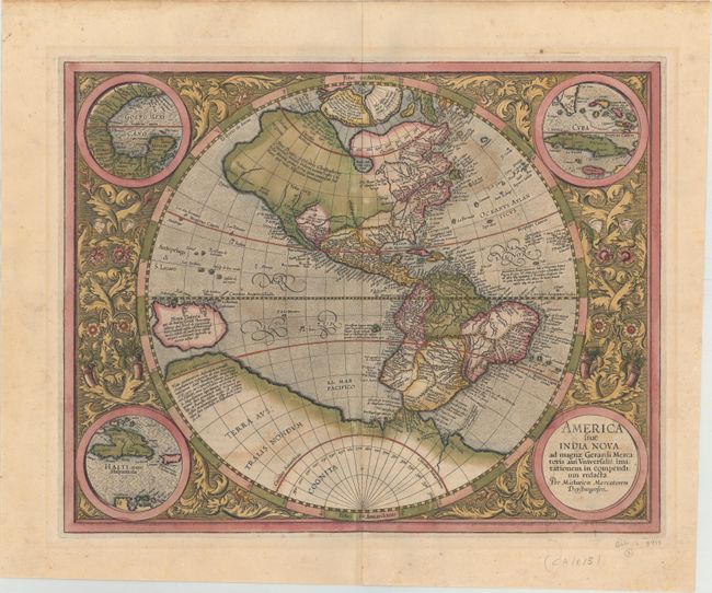
Auction 149, Lot 58
Subject: Western Hemisphere - America
Mercator, Michael
America Sive India Nova ad Magnae Gerardi Mercatoris aui Universalis Imitationem in Compendium Redacta, 1613
Size: 18.4 x 14.6 inches (46.7 x 37.1 cm)
Estimate: $5,500 - $6,500
Mercator's Foundation Map for the Americas in Full Original Color
Unsold
Closed on 5/21/2014
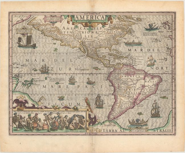
Auction 149, Lot 61
Subject: Western Hemisphere - America
Hondius, Jodocus
America, 1630
Size: 19.9 x 14.8 inches (50.5 x 37.6 cm)
Estimate: $4,750 - $6,000
Hondius' Important Map of the Americas in Full Original Color
Unsold
Closed on 5/21/2014
Auction 149, Lot 62
Subject: Western Hemisphere - America
Bertius/Tavernier
Carte de l'Amerique Corrigee et augmentee; dessus toutes les aultres cy devant faictes par P. Bertius, 1662
Size: 14.4 x 10.8 inches (36.6 x 27.4 cm)
Estimate: $1,800 - $2,100
Scarce Derivative of Hondius' Influential Map
Unsold
Closed on 5/21/2014
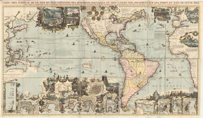
Auction 149, Lot 66
Subject: Western Hemisphere - America
Chatelain, Henry Abraham
Carte Tres Curieuse de la Mer du Sud, Contenant des Remarques Nouvelles et Tres Utiles Non Seulement sur les Ports et Iles de Cette Mer..., 1719
Size: 55 x 32.1 inches (139.7 x 81.5 cm)
Estimate: $16,000 - $18,000
Spectacular Wall Map Celebrating the New World
Sold for: $11,000
Closed on 5/21/2014
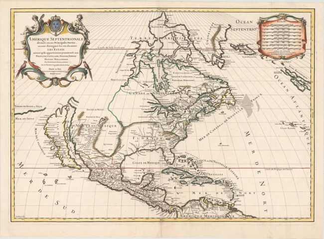
Auction 149, Lot 76
Subject: North America
Sanson/Jaillot
Amerique Septentrionale Divisee en ses Principales Parties, ou sont Distingues les uns des Autres les Estats…, 1698
Size: 25.5 x 18.1 inches (64.8 x 46 cm)
Estimate: $2,300 - $2,750
Rare Variant of a Superb Map Showing the Island of California
Sold for: $1,700
Closed on 5/21/2014
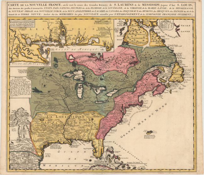
Auction 149, Lot 109
Subject: Colonial United States & Canada
Ottens/De Fer
Carte de la Nouvelle France, ou se Voit le Cours des Grandes Rivieres de S. Laurens & de Mississipi Aujour d'hui S. Louis..., 1745
Size: 21.6 x 19.5 inches (54.9 x 49.5 cm)
Estimate: $2,300 - $2,600
Reduced Version of De Fer's Influential Map of French Possessions in North America
Sold for: $1,700
Closed on 5/21/2014
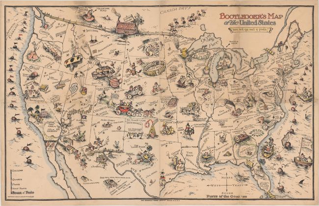
Auction 149, Lot 129
Subject: United States
Bootlegger's Map of the United States, 1926
Size: 32 x 22 inches (81.3 x 55.9 cm)
Estimate: $1,100 - $1,400
McCandish's Humorous Prohibition Map
Sold for: $800
Closed on 5/21/2014
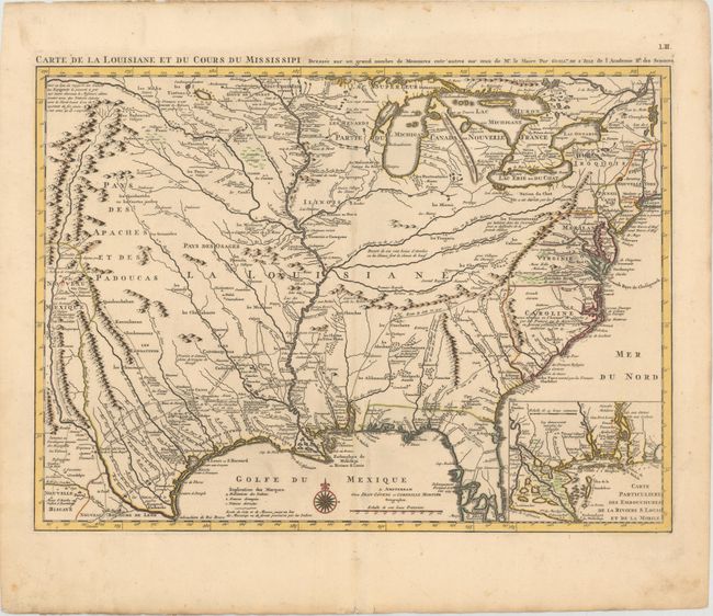
Auction 149, Lot 130
Subject: Colonial United States, Louisiana Territory
Delisle/Covens & Mortier
Carte de la Louisiane et du Cours du Mississipi Dressee sur un Grand Nombre de Memoires entr'autres sur ceux de Mr. le Maire, 1733
Size: 23.4 x 17.2 inches (59.4 x 43.7 cm)
Estimate: $2,750 - $3,500
Delisle's Influential Map of the Louisiana Territory
Sold for: $2,750
Closed on 5/21/2014
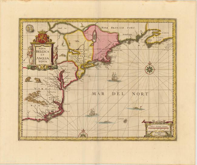
Auction 149, Lot 140
Subject: Colonial New England & Mid-Atlantic
Jansson/Valck & Schenk
Nova Belgica et Anglia Nova, 1694
Size: 19.5 x 15 inches (49.5 x 38.1 cm)
Estimate: $2,200 - $2,400
Jansson's Influential Map of the East Coast
Sold for: $1,500
Closed on 5/21/2014
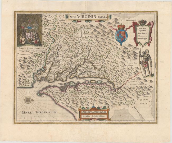
Auction 149, Lot 144
Subject: Colonial Mid-Atlantic United States
Hondius/Blaeu
Nova Virginiae Tabula, 1642
Size: 18.9 x 14.8 inches (48 x 37.6 cm)
Estimate: $2,750 - $3,500
One of the Most Important 17th Century Maps of the Chesapeake Bay - Full Original Color
Sold for: $1,850
Closed on 5/21/2014
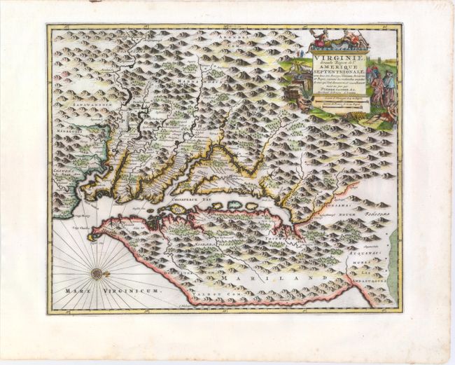
Auction 149, Lot 145
Subject: Colonial Mid-Atlantic United States
Aa, Pieter van der
Virginie, Grande Region de l'Amerique Septentrionale, avec Tous Ses Bourgs, Hameaux, Rivieres et Bayes, Suivant les Recherches Exactes de Ceux qui l'ont Decouverte, et Nouvellement Mise au Jour, 1729
Size: 14.1 x 11.4 inches (35.8 x 29 cm)
Estimate: $1,800 - $2,000
Rare Derivative of John Smith's Map of the Chesapeake Bay
Sold for: $1,300
Closed on 5/21/2014
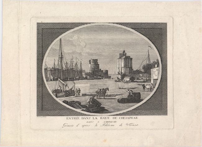
Auction 149, Lot 154
Subject: Colonial Chesapeake Bay
Anon.
Entree dans la Baye de Chesapeak dans l'Amerique, 1775
Size: 8.3 x 5.9 inches (21.1 x 15 cm)
Estimate: $160 - $200
Imaginary View of the Entrance to the Chesapeake Bay During the Revolutionary War
Sold for: $325
Closed on 5/21/2014
Auction 149, Lot 170
Subject: Colonial Central & Southern United States
Delisle, Guillaume
Carte de la Louisiane et du Cours du Mississipi Dressee sur un Grand Nombre de Memoires..., 1727
Size: 16.2 x 14 inches (41.1 x 35.6 cm)
Estimate: $2,000 - $2,300
Reduced-Size Edition of Delisle's Influential Map of the Louisiana Territory
Unsold
Closed on 5/21/2014
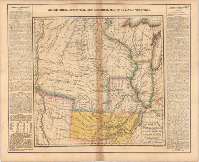
Auction 149, Lot 174
Subject: Central United States, Arkansas
Carey & Lea
Geographical, Statistical, and Historical Map of Arkansas Territory, 1822
Size: 14.7 x 14.5 inches (37.3 x 36.8 cm)
Estimate: $900 - $1,100
Important Map of "Arkansa" and Surroundings
Sold for: $650
Closed on 5/21/2014
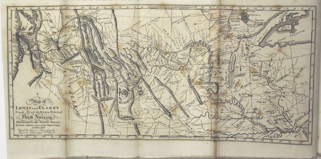
Auction 149, Lot 185
Subject: Western United States
Lewis & Clark
A Map of Lewis and Clark's Track, Across the Western Portion of North America from the Mississippi to the Pacific Ocean... [with] History of the Expedition Under the Command of Captains Lewis and Clarke, to the Sources of the Missouri…[Vol 1 Only], 1817
Size: 13.7 x 6.1 inches (34.8 x 15.5 cm)
Estimate: $6,500 - $8,000
Reduced Version of Lewis & Clark's Famous Map
Sold for: $7,500
Closed on 5/21/2014
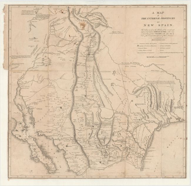
Auction 149, Lot 198
Subject: Southwestern United States
Pike, Zebulon
A Map of the Internal Provinces of New Spain, 1810
Size: 18.6 x 18 inches (47.2 x 45.7 cm)
Estimate: $3,500 - $4,500
A Cornerstone Map of Early Western Exploration
Sold for: $3,250
Closed on 5/21/2014
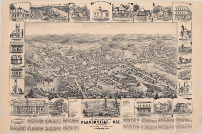
Auction 149, Lot 219
Subject: Placerville, California
Elliott, Wallace W.
Bird's Eye View Placerville, Cal., 1888
Size: 29 x 21 inches (73.7 x 53.3 cm)
Estimate: $2,750 - $3,500
View of California Gold Rush Town
Unsold
Closed on 5/21/2014
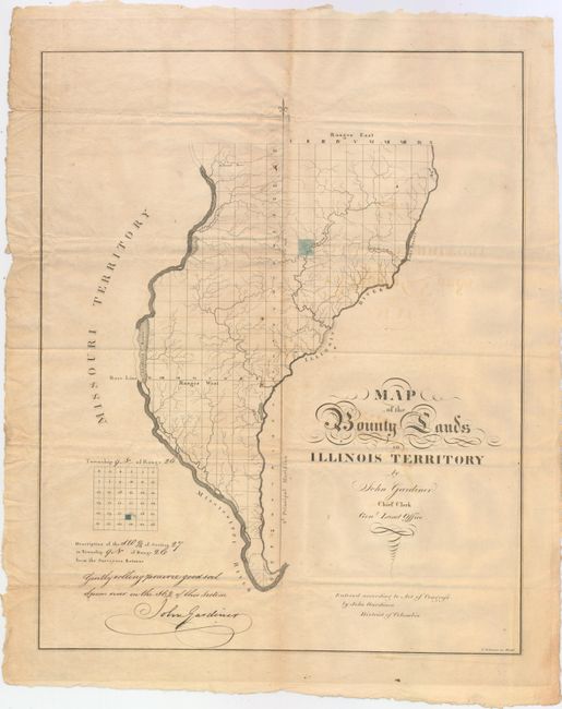
Auction 149, Lot 240
Subject: Western Illinois
Gardiner, John
Map of the Bounty Lands in Illinois Territory, 1818
Size: 14.9 x 18.6 inches (37.8 x 47.2 cm)
Estimate: $2,750 - $3,500
One of the Earliest Maps of Illinois
Sold for: $2,000
Closed on 5/21/2014
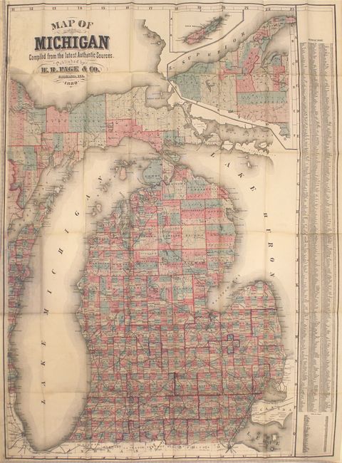
Auction 149, Lot 252
Subject: Michigan
Page, H. R.
Map of Michigan Compiled from the Latest Authentic Sources, 1880
Size: 24 x 36.5 inches (61 x 92.7 cm)
Estimate: $750 - $1,000
Rare Pocket Map of Michigan
Sold for: $550
Closed on 5/21/2014
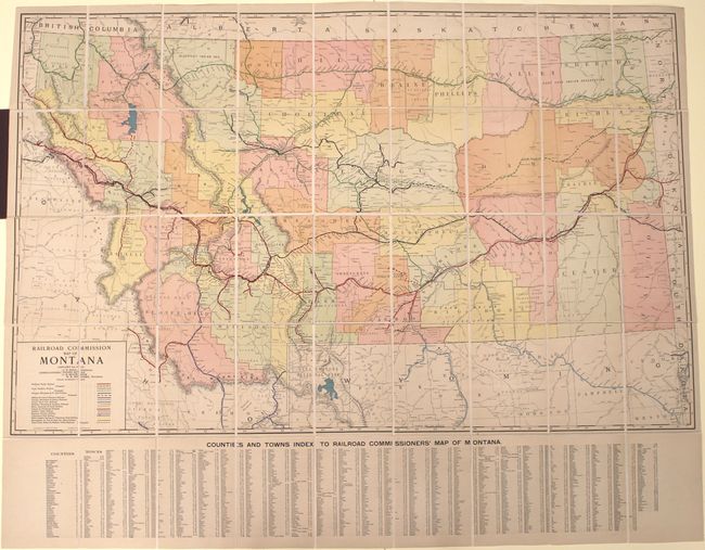
Auction 149, Lot 257
Subject: Montana, Railroads
Rand McNally & Co.
Railroad Commission Map of Montana, 1917
Size: 51.4 x 32.3 inches (130.6 x 82 cm)
Estimate: $900 - $1,100
Large, Attractive Railroad Map of Montana
Unsold
Closed on 5/21/2014
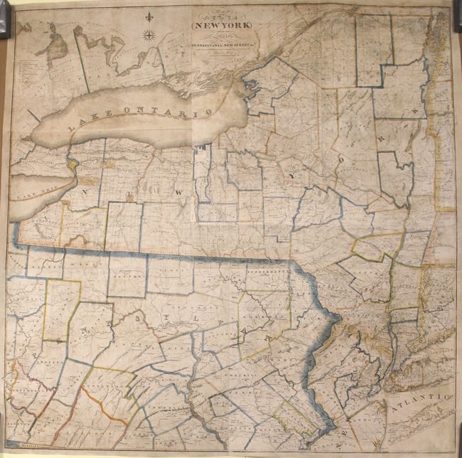
Auction 149, Lot 262
Subject: New York & Pennsylvania
Lay, Amos
Map of the State of New-York with Part of the States of Pennsylvania, New-Jersey &c., 1819
Size: 50.1 x 50 inches (127.3 x 127 cm)
Estimate: $3,000 - $3,750
Rare Wall Map of the State of New York
Unsold
Closed on 5/21/2014
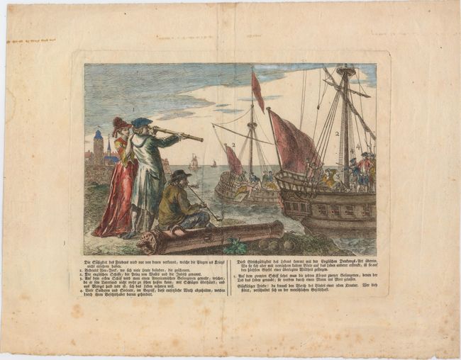
Auction 149, Lot 267
Subject: New York City, New York
Anon.
Die Sussigkeit des Friedens Wird Nur von Denen Verkannt, Welche die Plagen des Kriegs Nicht Erfahren Haben, 1790
Size: 10.1 x 6.7 inches (25.7 x 17 cm)
Estimate: $600 - $800
The Infamous British Prison Ships of the Revolutionary War
Unsold
Closed on 5/21/2014
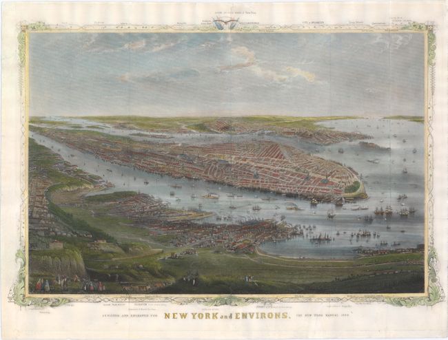
Auction 149, Lot 269
Subject: New York City, New York
Shannon, Joseph
New York and Environs, 1868
Size: 16.6 x 11.3 inches (42.2 x 28.7 cm)
Estimate: $1,000 - $1,300
Rare View of New York City
Sold for: $750
Closed on 5/21/2014
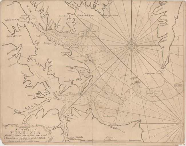
Auction 149, Lot 299
Subject: Eastern Virginia
Mount & Page
A Draught of Virginia from the Capes to York in York River and to Kuiquotan or Hamton in James River, 1751
Size: 23 x 18.1 inches (58.4 x 46 cm)
Estimate: $1,000 - $1,300
First Published Regional Map of Virginia
Sold for: $700
Closed on 5/21/2014
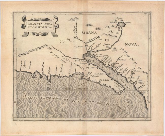
Auction 149, Lot 309
Subject: Southwestern United States & Mexico
Wytfliet, Cornelis
Granata Nova et California, 1597
Size: 11.4 x 9.1 inches (29 x 23.1 cm)
Estimate: $2,400 - $3,000
First Printed Map to Focus on California and the Southwest
Sold for: $2,500
Closed on 5/21/2014
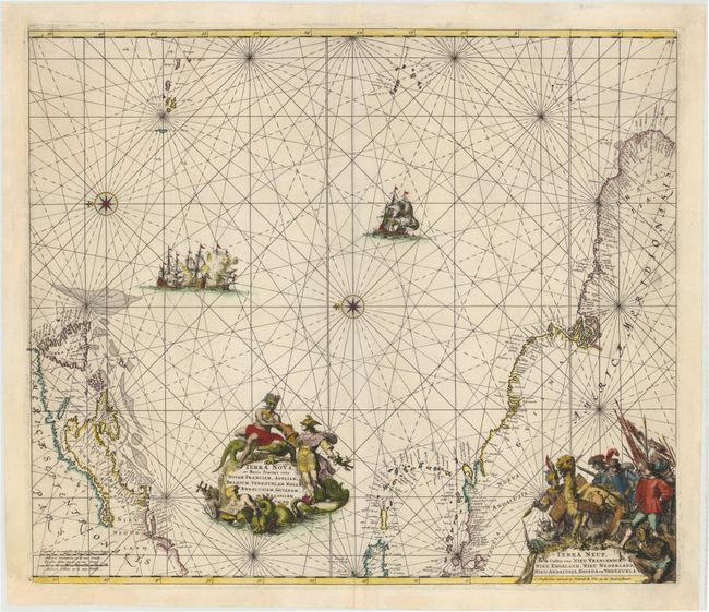
Auction 149, Lot 398
Subject: Atlantic Ocean
Wit, Frederick de
Terra Nova, ac Maris Tractus circa Novam Franciam, Angliam, Belgium, Venezuelam Novam Andalusiam, Guianam et Brasiliam - Terra Neuf, en de Custen van Nieu Vranckryck, Nieu Engeland, Nieu Nederland, Nieu Andalusia, Guiana en Venezuela, 1675
Size: 22.2 x 19 inches (56.4 x 48.3 cm)
Estimate: $1,300 - $1,600
Magnificent Decorative Chart of the Western Atlantic
Sold for: $950
Closed on 5/21/2014
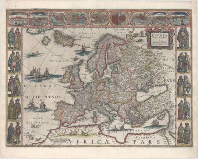
Auction 149, Lot 412
Subject: Europe
Blaeu, Willem
Europa Recens Descripta, 1643
Size: 22.1 x 16.3 inches (56.1 x 41.4 cm)
Estimate: $3,250 - $4,000
Blaeu's Carte-a-Figures Map of Europe
Sold for: $2,750
Closed on 5/21/2014
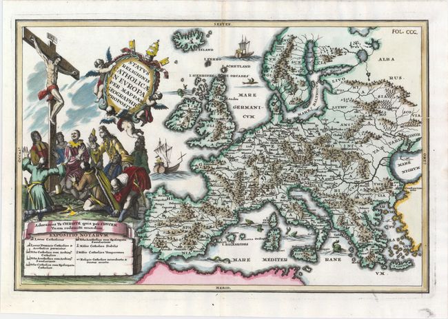
Auction 149, Lot 413
Subject: Europe
Scherer, Heinrich
Status Religionis Catholicae in Europa per Mappam Geographicam Proposit., 1702
Size: 13.8 x 9.1 inches (35.1 x 23.1 cm)
Estimate: $600 - $750
Rare Map Showing the Spread of Catholicism Through Europe
Sold for: $600
Closed on 5/21/2014
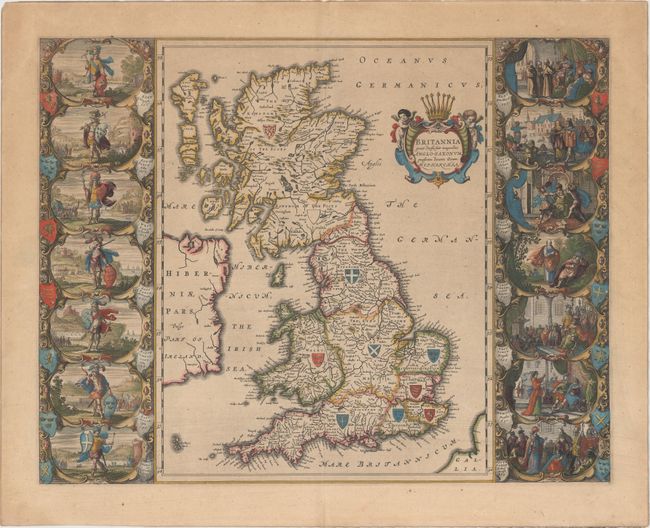
Auction 149, Lot 420
Subject: Britain
Blaeu, Johannes
Britannia Prout Divisa fuit Temporibus Anglo-Saxonum, Praesertim Durante Illorum Heptarchia, 1645
Size: 20.3 x 16.3 inches (51.6 x 41.4 cm)
Estimate: $3,000 - $4,000
Decorative Map of Britain with Vignettes of Saxon History
Sold for: $2,200
Closed on 5/21/2014
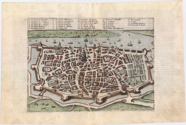
Auction 149, Lot 484
Subject: Antwerp, Belgium
Forlani, Paolo de
Anversa, 1569
Size: 10.8 x 7.9 inches (27.4 x 20.1 cm)
Estimate: $950 - $1,200
Forlani's Rare View of Antwerp
Unsold
Closed on 5/21/2014
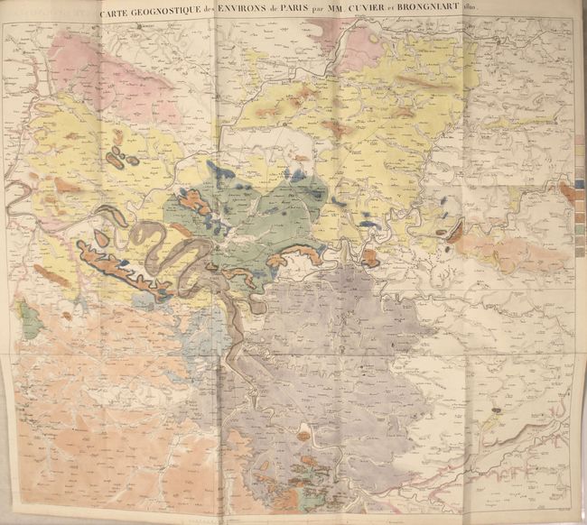
Auction 149, Lot 495
Subject: Paris, France
Memoires de la Classe des Sciences Mathematiques et Physiques de l'Institut Imperial de France, 1811
Size: 8.1 x 10.3 inches (20.6 x 26.2 cm)
Estimate: $1,500 - $1,800
First Modern Geological Map of Paris, France
Unsold
Closed on 5/21/2014
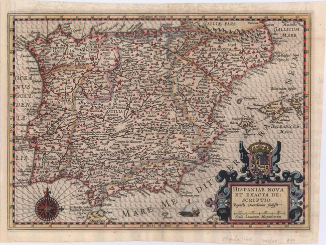
Auction 149, Lot 497
Subject: Spain & Portugal
Merula, Paulus G.
Hispaniae Nova et Exacta Descriptio, 1605
Size: 12.8 x 9.2 inches (32.5 x 23.4 cm)
Estimate: $1,000 - $1,300
Rare Map of the Iberian Peninsula
Sold for: $500
Closed on 5/21/2014
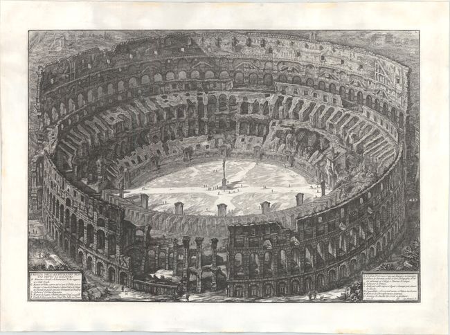
Auction 149, Lot 565
Subject: Rome, Italy
Piranesi, Giovanni Battista
Veduta dell' Anfiteatro Flavio detto il Colosseo, 1850
Size: 27.9 x 19.3 inches (70.9 x 49 cm)
Estimate: $2,000 - $2,400
Piranesi's Famous Bird's-Eye View of the Coliseum
Unsold
Closed on 5/21/2014
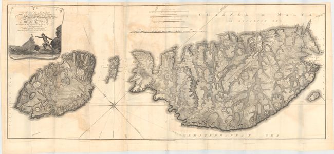
Auction 149, Lot 570
Subject: Malta
Neele, Samuel John
A New Sea & Land Chart of the Sovereign Principality of Malta; Laid Down from the Best Authorities and the Different Manuscript Maps Communicated to the Chevr. Louis de Boisgelin..., 1804
Size: 50.8 x 21.6 inches (129 x 54.9 cm)
Estimate: $2,500 - $3,500
Rare, Large Format Map of Malta
Sold for: $1,800
Closed on 5/21/2014
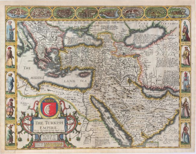
Auction 149, Lot 584
Subject: Middle East
Speed, John
The Turkish Empire. Newly Augmented, 1626
Size: 20.3 x 15.5 inches (51.6 x 39.4 cm)
Estimate: $2,750 - $3,500
Rare Carte-a-Figures Map of the Middle East
Sold for: $2,300
Closed on 5/21/2014
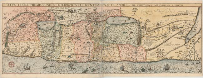
Auction 149, Lot 601
Subject: Holy Land
Adrichom, Christian van
Situs Terrae Promissionis SS Bibliorum Intelligentiam Exacte Aperiens, 1682
Size: 39.3 x 13.8 inches (99.8 x 35.1 cm)
Estimate: $1,800 - $2,100
Adrichom's Influential Map of the Holy Land
Sold for: $1,900
Closed on 5/21/2014
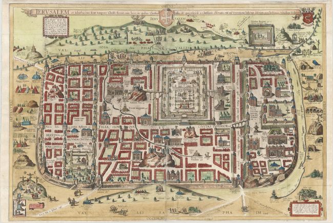
Auction 149, Lot 608
Subject: Jerusalem, Holy Land
Adrichom, Christian van
Ierusalem et Suburbia Eius, Sicut Tempore Christi Floruit, cum Locis, in Quibus Christus Passus Est: quae Religiose a Christianis Obseruata, Etia nu Venerationi Habetur Descripta, 1682
Size: 29.8 x 20.4 inches (75.7 x 51.8 cm)
Estimate: $2,000 - $2,300
Adrichom's Influential Bird's-Eye Plan of Jerusalem
Sold for: $2,750
Closed on 5/21/2014
61 lots
Page 1 of 2