Subject: World
Period: 1750 (dated)
Publication:
Color: Hand Color
Size:
21.9 x 12 inches
55.6 x 30.5 cm
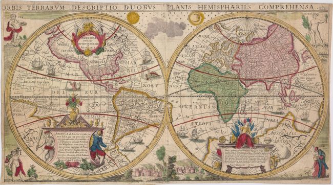
This decorative double-hemisphere world map is a scarce variant of Nicolaes Geelkercken and Henricus Hondius' map originally published in 1639 (see Shirley #348), which itself was a close copy of Geelkercken's world map of 1617 (see Shirley #295). Despite the fact that the date on the map has been amended to 1750, the geography has not been updated and still represents the world as it was known a century earlier based on the format established by Willem Blaeu. North and South America feature exaggerated coastlines with spurious lakes, rivers, mountain ranges, and place names. The R. S. Laurens stretches almost to the Rio Grande, and Quivira Regn. appears twice. A massive southern continent dominates the southern hemisphere and incorporates both Nova Guinea and Terra Australis. The discoveries of numerous explorers are shown, and the large cartouche at bottom left notes the voyages of Christopher Columbus, Ferdinand Magellan, Francis Drake, Thomas Cavendish, Olivier van Noort, and Joris van Spilbergen. In the eastern hemisphere, Korea is depicted as an island, and Japan and southeast Asia have very rudimentary outlines.
The spandrels feature figures representing the four seasons, however unlike the Geelkercken/Hondius map, the biblical scenes within the cusps have been replaced with the sun and moon at top and a lovely town view at bottom. We were not able to find any records of this map being for sale in the last 35 years, and only one example in a library catalog.
References: cf. Shirley #348.
Condition: B
Attractive old color on watermarked paper with some soiling, a light damp stain at top right, a few small worm holes, and narrow margins. There is a long horizontal crease through the middle of the map with a couple of minute holes along the crease. Some unusual printer's defects (appearing as small round circles) appear along the centerfold.


