Subject: Ancient World
Period: 1596 (circa)
Publication: Itinerarium Sacrae Scripturae
Color: Black & White
Size:
10 x 6.1 inches
25.4 x 15.5 cm
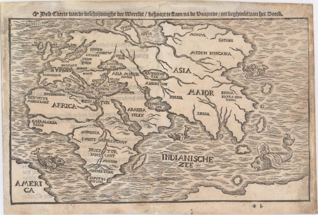
This scarce woodblock map focuses on the Old World showing Europe, Asia and Africa in outline with the locations of countries and a few principal cities noted. In Africa, the Nile originates in the Montes Lunae at the southern tip of the continent. A huge Caspian Sea and several enlarged river systems, including the Ganges River, dominate Asia. The most interesting parts of the map are in the bottom corners where there is a short coastline of Brazil, labeled America, at left and an unnamed landmass at right that appears to a part of Australia. Several sea monsters and a mermaid grace the oceans. Dutch text on verso.
References: cf. Shirley #143.
Condition: B+
A nice impression on watermarked paper with minor soiling. Professionally backed in Japanese tissue to repair a few minor centerfold separations and a tear that extends 2.7" into map at right, just below the mermaid. There are some chips and a worm track in blank margins that have all been professionally repaired.