Subject: Ancient World
Period: 1522 (dated)
Publication: Claudii Ptolemaei Alexandrini Geographicae Enarrationis…
Color: Black & White
Size:
19 x 13.9 inches
48.3 x 35.3 cm
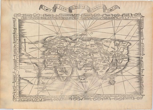
This highly desirable Ptolemaic world map is an excellent example of the evolving (yet still warped) medieval conception of the world's geography. Fries used Waldseemuller's 1513 edition of Ptolemy's Geographia as the source for most of the maps in his own edition, but this is Fries' own work, and it is even more inaccurate than Waldseemuller's rendering of the modern world. The name America appears for the first time on a Ptolemaic map and is used to identify South America, which appears with an entirely speculative western coastline. Even relatively well-known areas of the Old World become flawed in Fries' depiction. In Europe, Scotland and England are separate islands, and India is split into a double peninsula. Despite these distortions-- or because of them-- this map is much sought after. The map is bordered by a chain of banners naming the winds. This example was published in the 1535 edition and features an additional title banner that reads "Tabu Totius Orbis." When this banner was added, the plate developed a horizontal crack running from the middle of the right side of the map.
References: Shirley #48; Mickwitz & Miekkavaara #209-50.
Condition: A
A full sheet with very minor soiling, a printer's crease adjacent to centerfold, and a few minute worm tracks along the centerfold, only visible when held to light. An excellent example.