Subject: Colonial New England & Mid-Atlantic
Period: 1694 (circa)
Publication:
Color: Hand Color
Size:
19.5 x 15 inches
49.5 x 38.1 cm
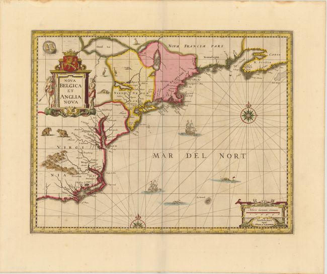
Jansson's influential map of the eastern coast of North America was first issued in 1636 with a less decorative title cartouche. It is derived from the less well-known 1630 map of Johannes de Laet, which is generally regarded as the source map for New England and the Northeast. It includes several very early depictions of colonial settlement including Manhattan and the Dutch colony of New Amsterdam, the Nordt Rivier (Hudson) and Zuydt Rivier (Delaware), along with Massachusetts and the English colony at Plymouth. The map includes part of the Great Lakes labeled Grand Lac and Lac des Yroquois, an unnamed Lake Champlain, and a fictitious lake at the headwaters of the Delaware River. In the second state, the title was shortened, giving greater prominence to the Dutch colonies, and wildlife was added throughout the interior. It is beautifully adorned with cartouches, ships, sea monsters and compass roses. This is the third state, with Jansson's imprint replaced by that of Valck & Schenk and the addition of dotted lines to mark the regions.
References: Burden #247; McCorkle #636.2.
Condition: A
A fine impression and wide, original margins with small stains in top blank margin, far from map. There is minor oxidation of the original green and yellow pigments.