Showing Featured Lots(remove filter)
Showing results for:Auction 142
Catalog Archive
87 lots
Page 1 of 2
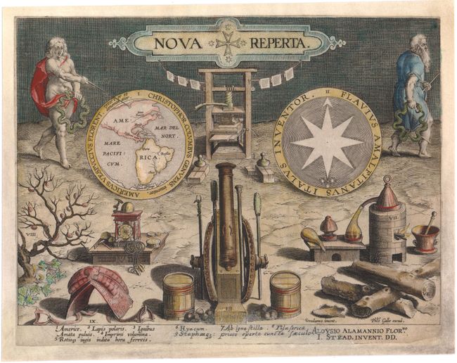
Auction 142, Lot 2
Subject: Title Pages, Western Hemisphere
Galle/Stradanus
Nova Reperta, 1600
Size: 10.5 x 8 inches (26.7 x 20.3 cm)
Estimate: $800 - $1,000
Unsold
Closed on 11/28/2012
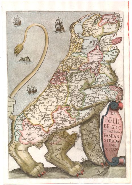
Auction 142, Lot 5
Subject: Title Pages - Low Countries
Strada, Famiamo, S.J.
De Bello Belgico Decas Prima Famiani Stradae Rom. Soc. Jesu, 1632
Size: 8.8 x 12.4 inches (22.4 x 31.5 cm)
Estimate: $6,000 - $8,000
Sold for: $4,500
Closed on 11/28/2012
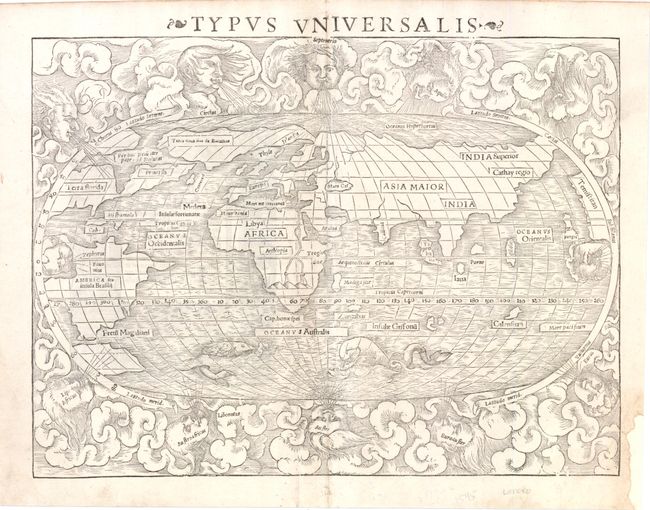
Auction 142, Lot 13
Subject: World
Munster, Sebastian
Typus Universalis, 1545
Size: 13.5 x 10.3 inches (34.3 x 26.2 cm)
Estimate: $5,500 - $6,500
First State of Munster's World Map
Unsold
Closed on 11/28/2012
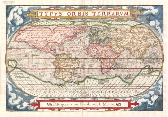
Auction 142, Lot 15
Subject: World
Belleforest, Francois
Typus Orbis Terrarum, 1575
Size: 19.6 x 13.3 inches (49.8 x 33.8 cm)
Estimate: $5,500 - $6,500
Scarce Woodcut Version of Ortelius’ World Map
Sold for: $4,000
Closed on 11/28/2012
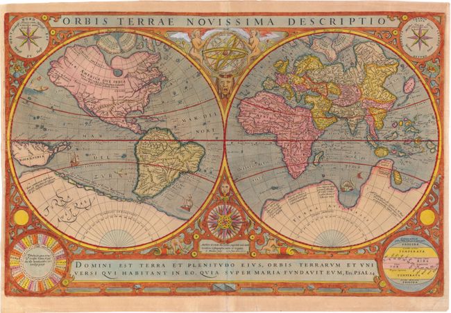
Auction 142, Lot 17
Subject: World
Le Clerc, Jean
Orbis Terrae Novissima Descriptio, 1602
Size: 20.2 x 13.1 inches (51.3 x 33.3 cm)
Estimate: $5,500 - $6,500
Rare World Map by Le Clerc
Sold for: $4,000
Closed on 11/28/2012
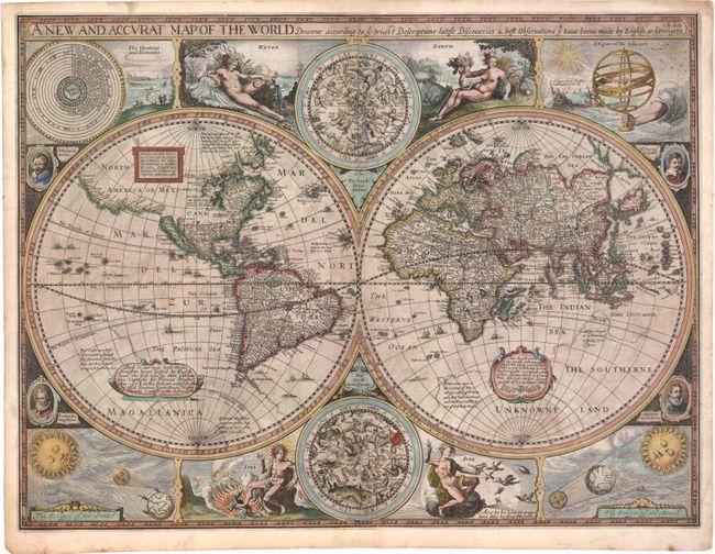
Auction 142, Lot 18
Subject: World
Speed, John
A New and Accurat Map of the World Drawne According to ye Truest Descriptions Latest Discoveries & Best Observations yt have beene Made by English or Strangers, 1626
Size: 20.5 x 15.8 inches (52.1 x 40.1 cm)
Estimate: $11,500 - $13,000
Speed's Double-Hemisphere World Map
Sold for: $10,500
Closed on 11/28/2012
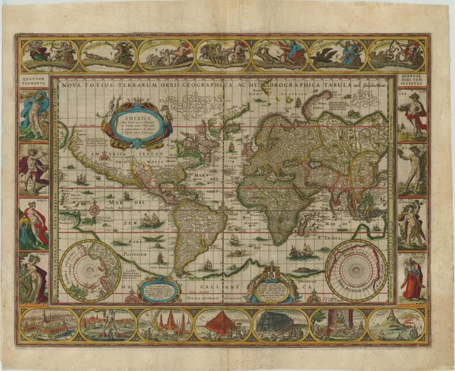
Auction 142, Lot 19
Subject: World
Blaeu, Willem
Nova Totius Terrarum Orbis Geographica ac Hydrographica Tabula, 1635
Size: 21.3 x 16.3 inches (54.1 x 41.4 cm)
Estimate: $15,000 - $18,000
Blaeu's Magnificent World Map
Sold for: $11,000
Closed on 11/28/2012
Auction 142, Lot 20
Subject: World
Camoens, Luis de
[Untitled - World], 1639
Size: 15.3 x 8 inches (38.9 x 20.3 cm)
Estimate: $5,500 - $6,500
A Scarce Spanish World Map
Unsold
Closed on 11/28/2012
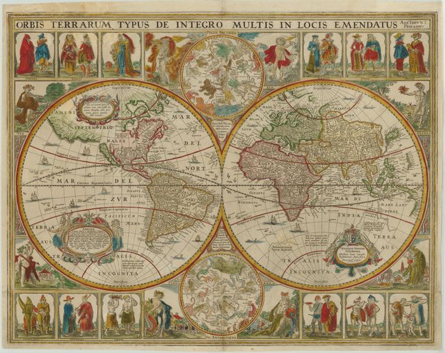
Auction 142, Lot 21
Subject: World
Visscher, Claes Janszoon
Orbis Terrarum Typus de Integro Multis in Locis Emendatus, 1652
Size: 22.2 x 17.3 inches (56.4 x 43.9 cm)
Estimate: $15,000 - $18,000
Visscher's Rare Cartes-a-Figures World Map
Unsold
Closed on 11/28/2012
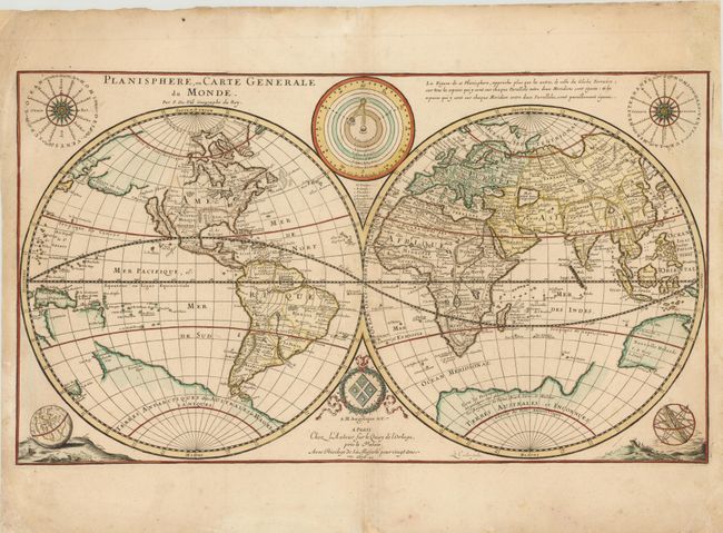
Auction 142, Lot 23
Subject: World
Duval, Pierre
Planisphere, ou Carte Generale du Monde…, 1676
Size: 23.5 x 13.3 inches (59.7 x 33.8 cm)
Estimate: $1,900 - $2,200
Unsold
Closed on 11/28/2012
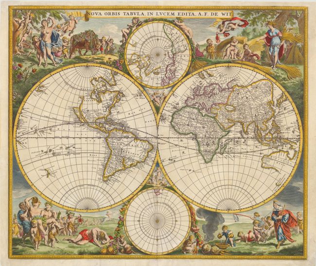
Auction 142, Lot 24
Subject: World
Wit, Frederick de
Nova Orbis Tabula, in Lucem Edita, 1675
Size: 22.3 x 19 inches (56.6 x 48.3 cm)
Estimate: $4,250 - $5,000
De Wit's Stunning Double-Hemisphere Map
Unsold
Closed on 11/28/2012
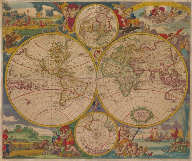
Auction 142, Lot 26
Subject: World
Danckerts, Justus
Nova Totius Terrarum Orbis Tabula Amstelodami per I. Danckerts cum Privil., 1685
Size: 23 x 19.3 inches (58.4 x 49 cm)
Estimate: $4,750 - $5,500
Unsold
Closed on 11/28/2012
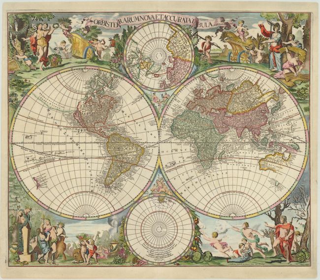
Auction 142, Lot 27
Subject: World
Valck, Gerard and Leonard
Orbis Terrarum Nova et Accurata Tabula, 1700
Size: 22.5 x 19 inches (57.2 x 48.3 cm)
Estimate: $6,000 - $7,000
Unsold
Closed on 11/28/2012
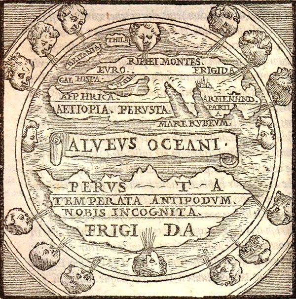
Auction 142, Lot 51
Subject: Ancient World
Macrobius, Ambrosius Aurelius Theodo
Macrobii Ambrosii Aurelii Theodosii, uiri Consularis, et Illustris, In Somnium Scipionis, Lib. II. Saturnaliorum. Lib. VII…, 1574
Size: 5 x 7 inches (12.7 x 17.8 cm)
Estimate: $1,400 - $1,800
Macrobius' Miniature World Map
Unsold
Closed on 11/28/2012
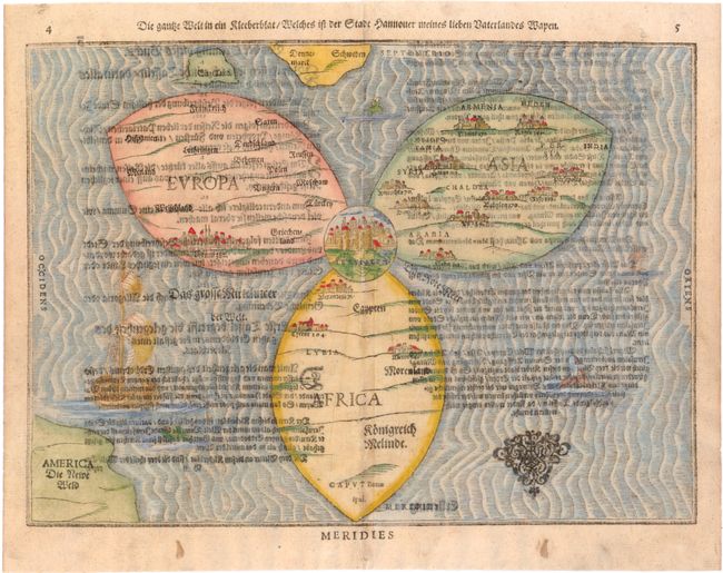
Auction 142, Lot 52
Subject: Ancient World
Bunting, Heinrich
Die Gantze Welt in ein Kleeberblat / Welches ist der Stadt Hannover Meines Lieben Vaterlandes Wapen, 1581
Size: 14.1 x 10.2 inches (35.8 x 25.9 cm)
Estimate: $5,500 - $6,500
Bunting's Clover Leaf Map of the Old World
Sold for: $2,750
Closed on 11/28/2012
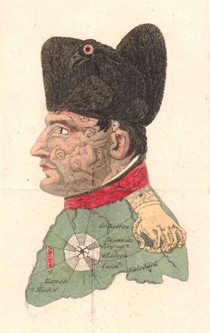
Auction 142, Lot 73
Subject: Cartographic Miscellany, Napoleon, Germany
[Lot of 2 - Napoleon Bonaparte Portrait], 1814
Size: 2.5 x 4 inches (6.4 x 10.2 cm)
Estimate: $700 - $1,000
Famous Caricature of Napoleon
Unsold
Closed on 11/28/2012
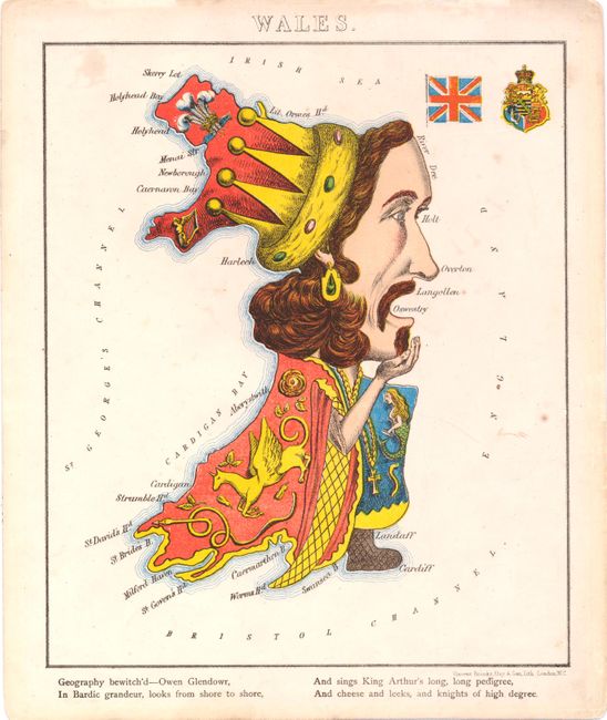
Auction 142, Lot 76
Subject: Cartographic Miscellany
Aleph
Wales, 1869
Size: 7.8 x 10.2 inches (19.8 x 25.9 cm)
Estimate: $250 - $325
Sold for: $180
Closed on 11/28/2012
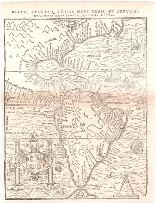
Auction 142, Lot 77
Subject: Western Hemisphere
Bellere, Jean
Brevis, Exactaq. Totius Novi Orbis, et Peruviae Regionis Descriptio, Recens Edita, 1566
Size: 5.2 x 6.5 inches (13.2 x 16.5 cm)
Estimate: $6,000 - $8,000
Rare, Early Map of the Americas by Bellere
Sold for: $4,000
Closed on 11/28/2012
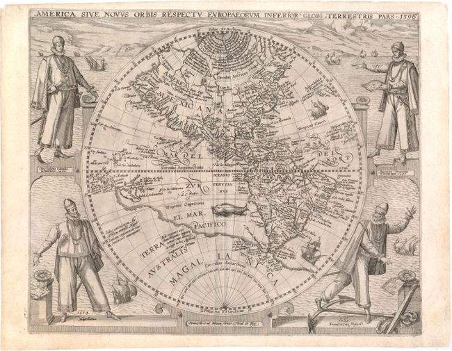
Auction 142, Lot 78
Subject: Western Hemisphere
Bry, Theodore de
America Sive Novus Orbis Respectu Europaeorum Inferior Globi Terrestris Pars, 1596
Size: 15.5 x 12.8 inches (39.4 x 32.5 cm)
Estimate: $6,500 - $8,000
Sold for: $7,000
Closed on 11/28/2012
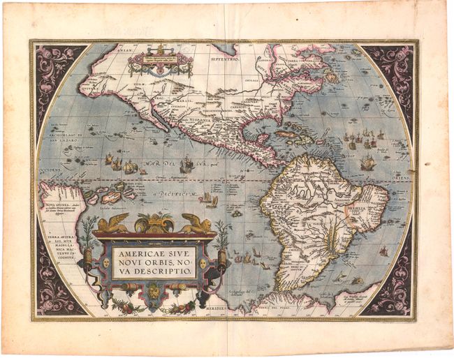
Auction 142, Lot 79
Subject: Western Hemisphere
Ortelius, Abraham
Americae sive Novi Orbis, Nova Descriptio, 1598
Size: 20 x 14.5 inches (50.8 x 36.8 cm)
Estimate: $6,000 - $7,500
Sold for: $5,000
Closed on 11/28/2012
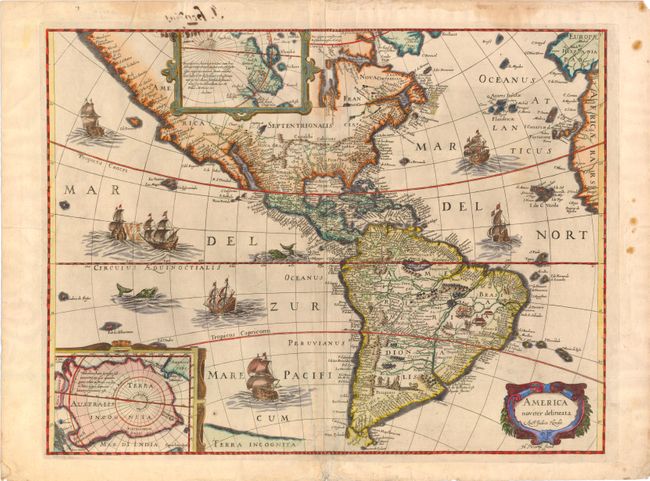
Auction 142, Lot 80
Subject: Western Hemisphere
Boisseau, Jean
America Noviter Delineata, 1636
Size: 19.8 x 15 inches (50.3 x 38.1 cm)
Estimate: $3,000 - $4,000
Rare Boisseau Edition of Hondius' Famous Map of the Americas
Sold for: $1,200
Closed on 11/28/2012
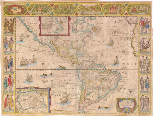
Auction 142, Lot 82
Subject: Western Hemisphere
Anon.
America Noviter Delineata Auct: Judoco Hondio, 1659
Size: 21.5 x 16.2 inches (54.6 x 41.1 cm)
Estimate: $4,000 - $5,500
Very Rare Derivative of Hondius' Map of the Americas
Unsold
Closed on 11/28/2012
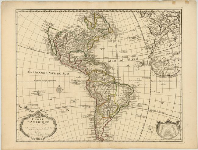
Auction 142, Lot 86
Subject: Western Hemisphere
Delisle, Guillaume
Carte d'Amerique Dressee pour l'Usage du Roy…, 1722
Size: 24.3 x 19.3 inches (61.7 x 49 cm)
Estimate: $1,100 - $1,400
Scarce First State of One of the Most Popular American Maps of the Eighteenth Century
Sold for: $1,300
Closed on 11/28/2012
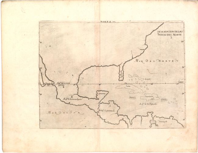
Auction 142, Lot 96
Subject: North America
Herrera y Tordesillas, Antonio de
Descripcion de las Yndias del Norte 2, 1601
Size: 10.8 x 8 inches (27.4 x 20.3 cm)
Estimate: $1,400 - $1,600
Unsold
Closed on 11/28/2012
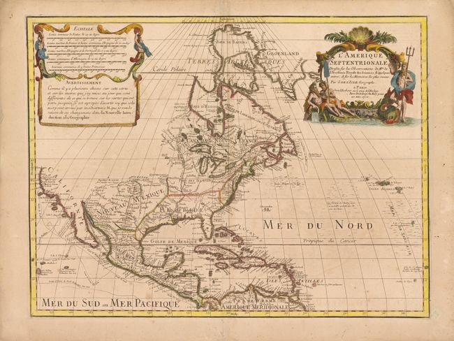
Auction 142, Lot 100
Subject: North America
Delisle, Guillaume
L'Amerique Septentrionale Dressee sur les Observations de Mrs. de l'Academie Royale des Sciences…, 1700
Size: 23.8 x 18 inches (60.5 x 45.7 cm)
Estimate: $2,000 - $2,500
Delisle's Foundation Map of North America
Unsold
Closed on 11/28/2012
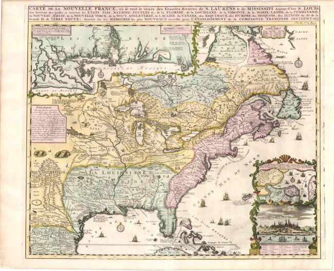
Auction 142, Lot 123
Subject: Colonial United States and Canada
Chatelain, Henry Abraham
Carte de la Nouvelle France, ou se voit le cours des Grandes Rivieres de S. Laurens & de Mississipi Aujour d'hui S. Louis, aux Environs des-quelles se trouvent les Etats, Pais, Nations, Peuples &c., 1719
Size: 19.3 x 16.5 inches (49 x 41.9 cm)
Estimate: $2,000 - $2,400
Sold for: $1,500
Closed on 11/28/2012
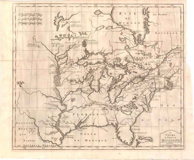
Auction 142, Lot 124
Subject: Colonial United States and Canada, Great Lakes
Bernard, Jean Frederic
Le Cours du Fleuve Missisipi Selon les Relations les Plus Modernes, 1737
Size: 17.2 x 14.6 inches (43.7 x 37.1 cm)
Estimate: $2,000 - $2,300
Sold for: $1,500
Closed on 11/28/2012
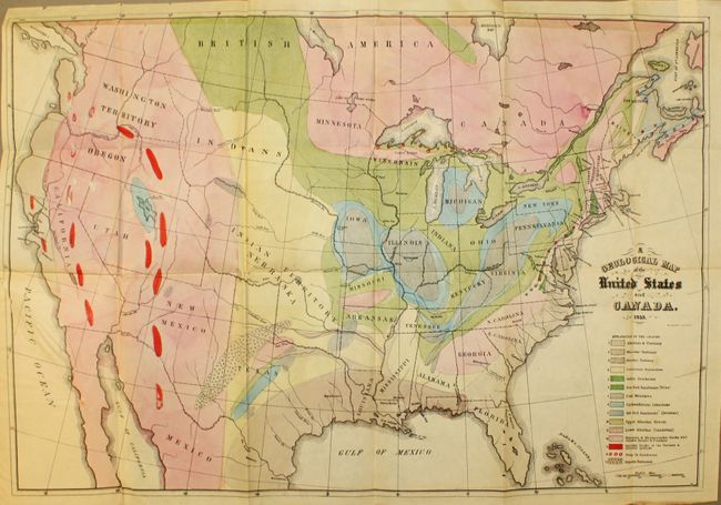
Auction 142, Lot 136
Subject: United States and Canada
Hitchcock, Edward
[Maps with Report] A Geological Map of the United States and Canada [and] Outline of the Geology of the Globe, 1853
Size: See Description
Estimate: $1,000 - $1,300
First Edition of Hitchcock's Important Maps and Report
Sold for: $1,300
Closed on 11/28/2012
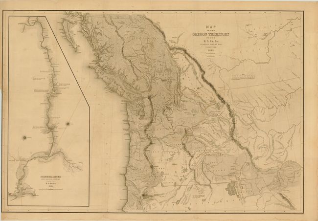
Auction 142, Lot 143
Subject: Western Canada & United States
Wilkes, Charles
Map of the Oregon Territory by the U.S. Ex. Ex., 1841
Size: 33.8 x 22.8 inches (85.9 x 57.9 cm)
Estimate: $1,500 - $2,000
Sold for: $1,100
Closed on 11/28/2012
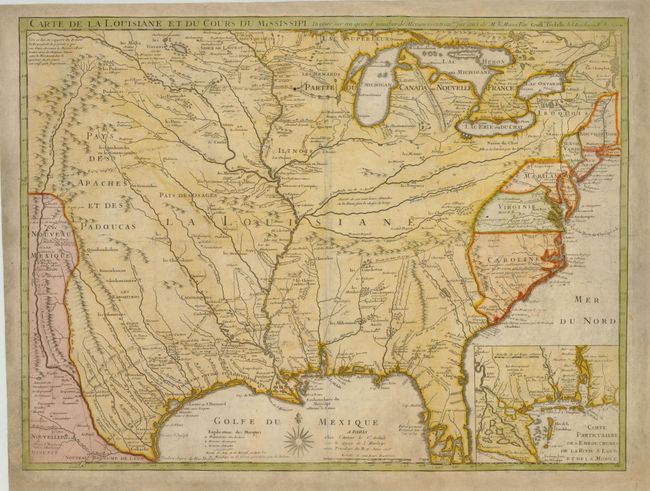
Auction 142, Lot 154
Subject: Colonial United States, Louisiana Territory
Delisle, Guillaume
Carte de la Louisiane et du Cours du Mississipi Dressee sur un Grand Nombre de Memoires..., 1718
Size: 25.5 x 19.2 inches (64.8 x 48.8 cm)
Estimate: $10,000 - $15,000
A Foundation Map for the Mississippi Valley and the First Appearance of Texas on a Printed Map
Unsold
Closed on 11/28/2012
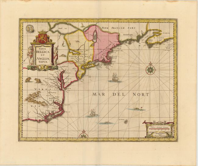
Auction 142, Lot 162
Subject: Colonial New England & Mid-Atlantic
Jansson/Valck & Schenk
Nova Belgica et Anglia Nova, 1694
Size: 19.5 x 15 inches (49.5 x 38.1 cm)
Estimate: $2,300 - $2,500
Jansson's Influential Map of the East Coast
Unsold
Closed on 11/28/2012
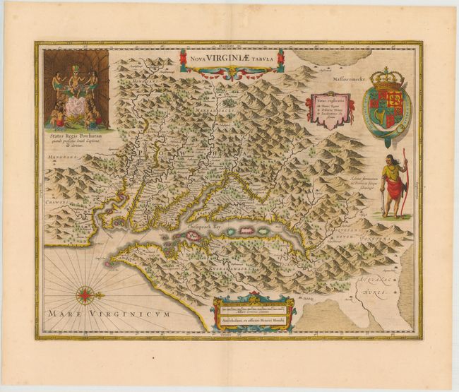
Auction 142, Lot 169
Subject: Colonial Mid-Atlantic
Hondius, Henricus
Nova Virginiae Tabula, 1638
Size: 19.4 x 15 inches (49.3 x 38.1 cm)
Estimate: $2,200 - $2,500
One of the Most Important 17th Century Maps of the Chesapeake Bay
Sold for: $1,600
Closed on 11/28/2012
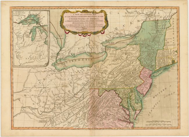
Auction 142, Lot 173
Subject: Mid-Atlantic United States & Great Lakes
Laurie & Whittle
A New and General Map of the Middle Dominions Belonging to the United States of America, viz. Virginia, Maryland, the Delaware-Counties, Pennsylvania, New Jersey &c. with the Addition of New York, & of the Greatest Part of New England…, 1794
Size: 26 x 18.8 inches (66 x 47.8 cm)
Estimate: $1,500 - $1,800
Laurie & Whittle's Popular Map Depicting the "New" United States
Unsold
Closed on 11/28/2012
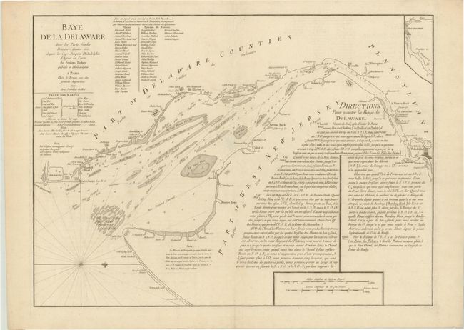
Auction 142, Lot 174
Subject: Delaware Bay
Le Rouge, George Louis
Baye de la Delaware avec les Ports, Sondes, Dangers, Bancs &c. depuis les Caps Jusqu'a Philadelphie…, 1777
Size: 25.8 x 19 inches (65.5 x 48.3 cm)
Estimate: $2,000 - $2,400
The Most Accurate Chart of Delaware Bay in the 18th Century
Sold for: $1,200
Closed on 11/28/2012
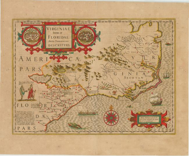
Auction 142, Lot 175
Subject: Colonial Southeast
Hondius, Jodocus
Virginiae Item et Floridae Americae Provinciarum, Nova Descriptio, 1623
Size: 19.1 x 13.5 inches (48.5 x 34.3 cm)
Estimate: $2,400 - $3,000
A Seminal Map of the Southeast and Early American Cartography
Unsold
Closed on 11/28/2012
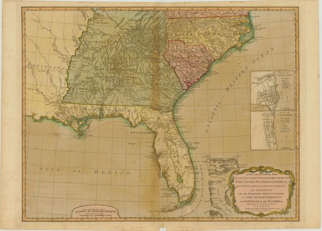
Auction 142, Lot 181
Subject: Southeast United States
Laurie & Whittle
A New and General Map of the Southern Dominions Belonging to the United States of America viz: North Carolina, South Carolina, and Georgia with … Louisiana and Florida, 1794
Size: 24.8 x 19.5 inches (63 x 49.5 cm)
Estimate: $1,600 - $1,800
Sold for: $950
Closed on 11/28/2012
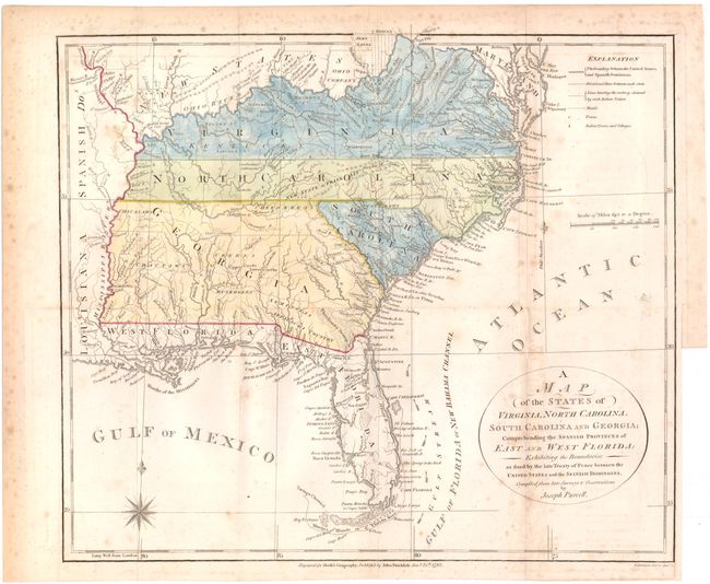
Auction 142, Lot 184
Subject: Southern United States
Purcell, Joseph
A Map of the States of Virginia, North Carolina, South Carolina and Georgia: Comprehending the Spanish Provinces of East and West Florida: Exhibiting the Boundaries as Fixed by the Late Treaty of Peace Between the United States and the Spanish Dominions, 1792
Size: 14.5 x 12.5 inches (36.8 x 31.8 cm)
Estimate: $800 - $1,000
An Early Map Locating the Proposed State of Franklin
Sold for: $600
Closed on 11/28/2012
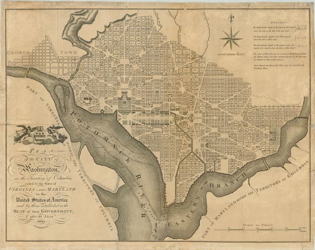
Auction 142, Lot 226
Subject: Washington, D.C.
Russell, John C.
Plan of the City of Washington, in the Territory of Columbia, Ceded by the States of Virginia and Maryland to the United States of America, and by Them Established as the Seat of Their Government, After the Year 1800, 1795
Size: 21 x 15.8 inches (53.3 x 40.1 cm)
Estimate: $2,000 - $2,500
Rare, Early Large Format Map of Washington D.C.
Sold for: $1,700
Closed on 11/28/2012
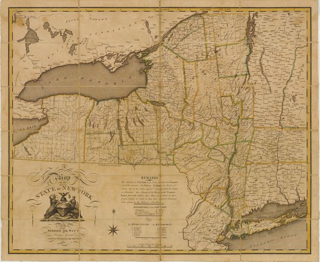
Auction 142, Lot 251
Subject: New York
Witt, Simeon de
A Map of the State of New York … Contracted from His Large Map of the State, 1804
Size: 27.3 x 22.3 inches (69.3 x 56.6 cm)
Estimate: $3,000 - $4,000
Pocket Version of Simeon de Witt's Landmark Map of New York
Sold for: $2,750
Closed on 11/28/2012
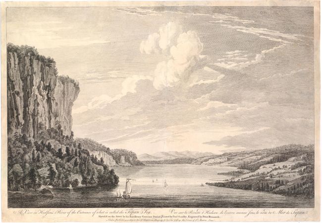
Auction 142, Lot 254
Subject: Hudson River, New York
Pownall, Thomas
A View in Hudson's River of the Entrance of What Is Called the Topan Sea / Vue sur la Riviere d'Hudson, de l'Entrée Counue sous le Nom de Mer de Topan, 1761
Size: 20 x 13.1 inches (50.8 x 33.3 cm)
Estimate: $2,100 - $2,400
Unsold
Closed on 11/28/2012
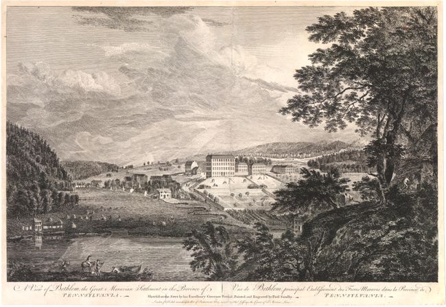
Auction 142, Lot 267
Subject: Bethlehem, Pennsylvania
Pownall, Thomas
A View of Bethlem, the Great Moravian Settlement in the Province of Pennsylvania / Vue de Bethlem, Principal Etablissement des Freres Moraves dans la Province de Pennsylvania, 1761
Size: 20.3 x 12.9 inches (51.6 x 32.8 cm)
Estimate: $2,100 - $2,400
Unsold
Closed on 11/28/2012
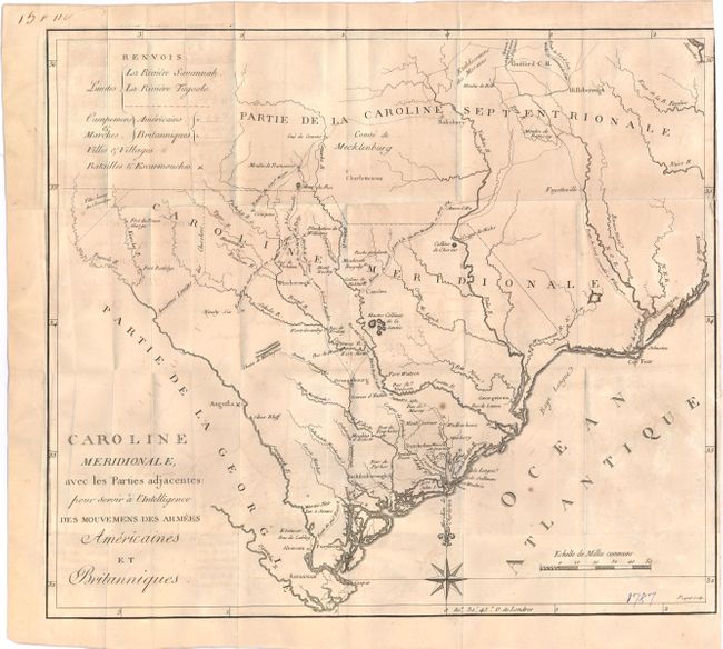
Auction 142, Lot 268
Subject: South Carolina
Ramsay, David
Caroline Meridionale, avec les Parties adjacentes: pour servir a l'Intelligence des mouvemens des armees Americaines et Britanniques, 1787
Size: 16.4 x 14.4 inches (41.7 x 36.6 cm)
Estimate: $900 - $1,100
Sold for: $450
Closed on 11/28/2012
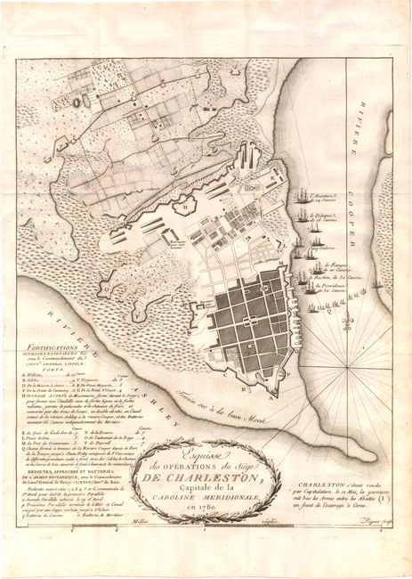
Auction 142, Lot 270
Subject: Charleston, South Carolina
Ramsay, David
[Lot of 2] Esquisse des Operations du Siege de Charleston, Capitale de la Caroline Meridionale, en 1780 [and] Plan du Havre de Charleston, Montrant la Disposition de la Flotte Britannique..., 1787
Size: See Description
Estimate: $800 - $1,000
Sold for: $400
Closed on 11/28/2012
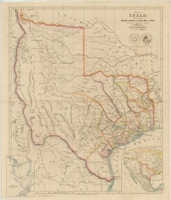
Auction 142, Lot 273
Subject: Texas
Arrowsmith, John
Map of Texas, Compiled from Surveys Recorded in the Land Office of Texas, and other Official Surveys, 1841
Size: 19.8 x 24 inches (50.3 x 61 cm)
Estimate: $16,000 - $20,000
Arrowsmith's Important Map of the Republic of Texas
Sold for: $15,000
Closed on 11/28/2012
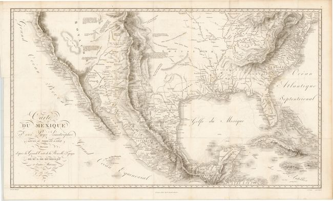
Auction 142, Lot 292
Subject: United States & Mexico
Humboldt, Friedrich Heinrich Alexander von
Carte du Mexique et des Pays Limitrophes Situes au Nord et a l'Est Dressee d'apres la Grande Carte de la Nouvelle Espagne, 1811
Size: 28.5 x 16.6 inches (72.4 x 42.2 cm)
Estimate: $2,500 - $3,250
Unsold
Closed on 11/28/2012
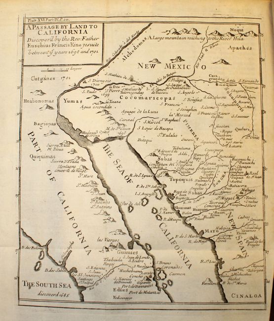
Auction 142, Lot 295
Subject: Southwestern United States & Mexico
Kino, Eusebio Francisco, SJ
A Passage by Land to California Discover'd by ye Rev. Fathr. Eusebius Francis Kino Jesuite between ye Years 1698 & 1701 [Map in The Philosophical Transactions…], 1721
Size: 7.5 x 9.3 inches (19.1 x 23.6 cm)
Estimate: $1,500 - $1,900
Father Kino's Important Map of California
Unsold
Closed on 11/28/2012
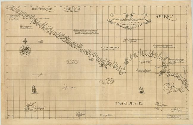
Auction 142, Lot 301
Subject: California and Baja Mexico
Dudley, Robert (Sir)
Carta Particolare della America e Parte Maestrale dal C: di Cedros…, 1648
Size: 30 x 18.5 inches (76.2 x 47 cm)
Estimate: $2,750 - $3,500
Rare First State of Dudley's Chart of the Coast of California
Sold for: $3,250
Closed on 11/28/2012
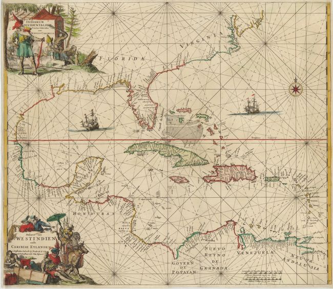
Auction 142, Lot 316
Subject: Gulf of Mexico and Caribbean
Wit, Frederick de
Indiarum Occidentalium Tractus Littorales cum Insulis Caribicis ... / Pascaert van Westindien ende Caribise Eylanden…, 1680
Size: 22.2 x 19.2 inches (56.4 x 48.8 cm)
Estimate: $2,000 - $2,400
A Magnificent Sea Chart of the West Indies
Sold for: $1,500
Closed on 11/28/2012
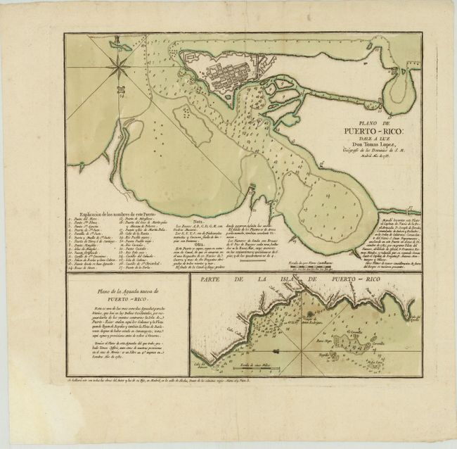
Auction 142, Lot 334
Subject: San Juan, Puerto Rico
Lopez de Vargas Machuca, Thomas (don)
Plano de Puerto-Rico: Dale a Luz [on sheet with] Parte de la Isla de Puerto-Rico, 1785
Size: 14.5 x 14 inches (36.8 x 35.6 cm)
Estimate: $1,500 - $1,800
Rare Chart of San Juan
Sold for: $1,700
Closed on 11/28/2012
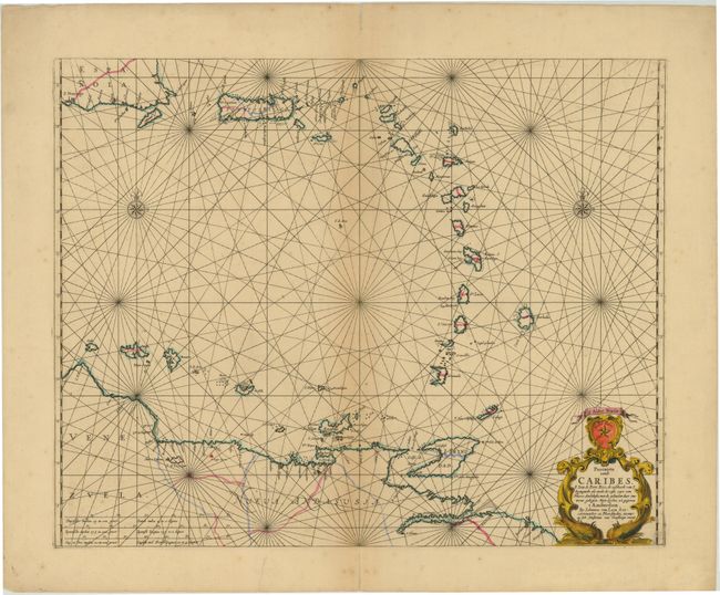
Auction 142, Lot 336
Subject: Lesser Antilles
Loon, Jan van
Pascaerte vande Caribes, S. Iuan de Porte Rico..., 1666
Size: 21.2 x 17 inches (53.8 x 43.2 cm)
Estimate: $2,000 - $2,300
Unsold
Closed on 11/28/2012
87 lots
Page 1 of 2