Showing Featured Lots(remove filter)
Filtered by Category:United States(Show All Categories)
Showing results for:Auction 173
Catalog Archive
18 lots
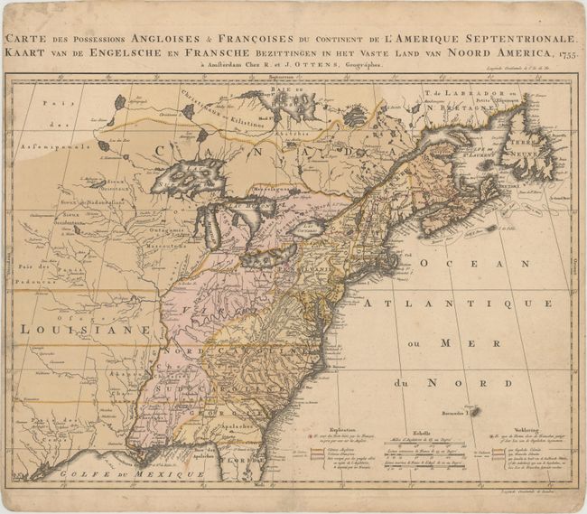
Auction 173, Lot 72
Subject: Colonial Eastern United States & Canada
Ottens, Reiner and Joshua
Carte des Possessions Angloises & Francoises du Continent de l'Amerique Septentrionale / Kaart van de Engelsche en Fransche Bezittingen in het Vaste Land van Noord America, 1755
Size: 22.4 x 16.3 inches (56.9 x 41.4 cm)
Estimate: $2,000 - $2,300
Dutch Version of an Important Map Showing Territorial Claims at the Outset of the French and Indian War
Unsold
Closed on 6/5/2019
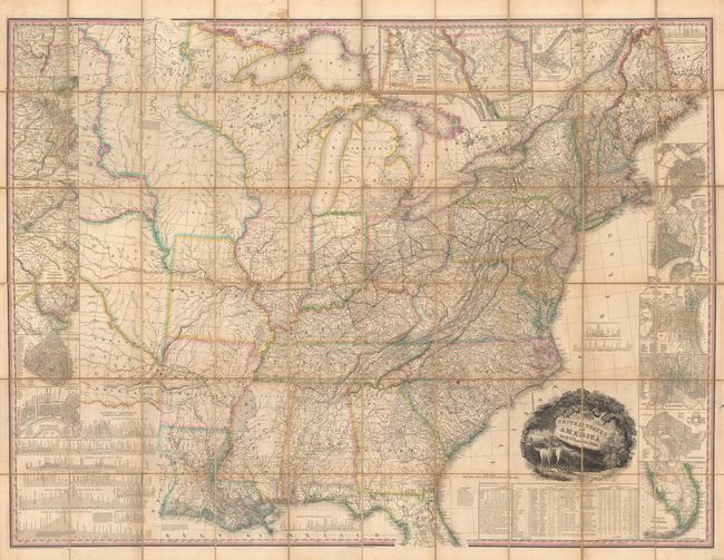
Auction 173, Lot 77
Subject: United States
Tanner, Henry Schenck
United States of America [with] Memoir on the Recent Surveys, Observations, and Internal Improvements, in the United States... [and] Memoir on the Recent Surveys ... Second Edition, 1829
Size: 61 x 45.7 inches (154.9 x 116.1 cm)
Estimate: $9,500 - $12,000
First Edition of Tanner's Important Map of the United States
Sold for: $7,000
Closed on 6/5/2019
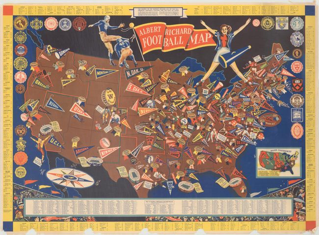
Auction 173, Lot 80
Subject: United States, Football
Albert Richard Football Map, 1940
Size: 25.5 x 18.5 inches (64.8 x 47 cm)
Estimate: $300 - $400
A WWII-Era Map Celebrating College Football
Sold for: $500
Closed on 6/5/2019
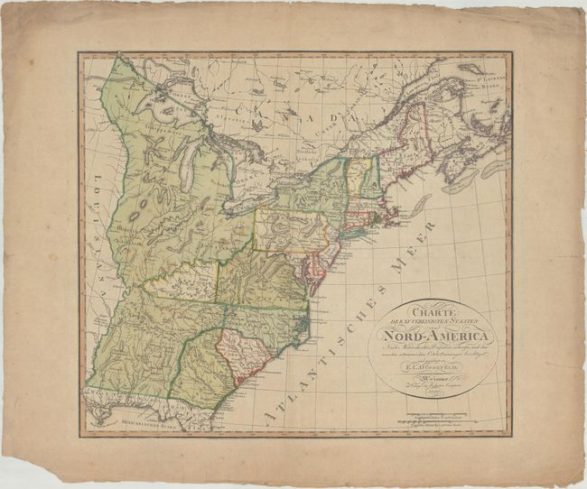
Auction 173, Lot 83
Subject: Eastern United States, Franklin
Gussefeld, Franz Ludwig
Charte der XV Vereinigten Staaten von Nord-America Nach Murdochischer Projection..., 1800
Size: 20.4 x 18.4 inches (51.8 x 46.7 cm)
Estimate: $1,000 - $1,300
Map Depicting the Proposed State of Franklin
Sold for: $850
Closed on 6/5/2019
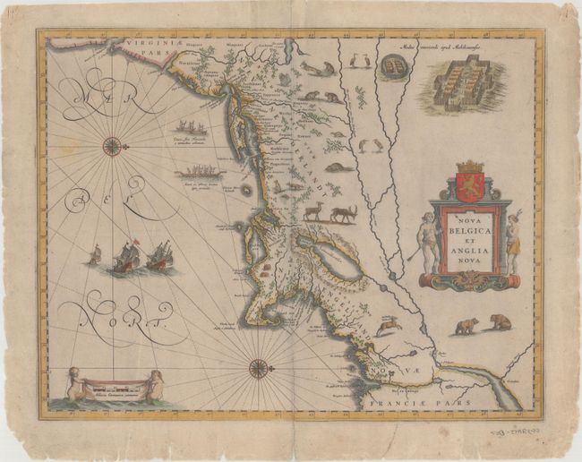
Auction 173, Lot 91
Subject: Colonial New England & Mid-Atlantic United States
Blaeu, Willem
Nova Belgica et Anglia Nova, 1635
Size: 19.5 x 15.3 inches (49.5 x 38.9 cm)
Estimate: $2,200 - $2,500
Important Map of Colonial New England and the Mid-Atlantic - Rare Example with Blank Verso
Sold for: $1,600
Closed on 6/5/2019
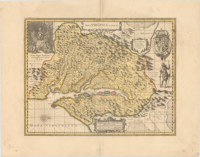
Auction 173, Lot 95
Subject: Colonial Mid-Atlantic United States
Hondius/Schenk & Valck
Nova Virginiae Tabula, 1700
Size: 19.2 x 14.8 inches (48.8 x 37.6 cm)
Estimate: $1,100 - $1,400
One of the Most Important 17th Century Maps of the Chesapeake Bay
Sold for: $750
Closed on 6/5/2019
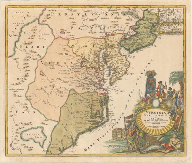
Auction 173, Lot 96
Subject: Colonial Mid-Atlantic United States
Homann, Johann Baptist
Virginia Marylandia et Carolina in America Septentrionali Britannorum Industria Excultae, 1730
Size: 22.8 x 19.2 inches (57.9 x 48.8 cm)
Estimate: $1,900 - $2,200
Map Created to Promote German Immigration to the New World
Sold for: $1,175
Closed on 6/5/2019
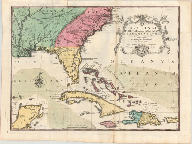
Auction 173, Lot 101
Subject: Colonial Southeast United States, Bahamas & Greater Antilles
Seligmann, Johann Michael
Carolinae Floridae nec non Insularum Bahamensium cum Partibus Adjacendibus Delineatio ad Exemplar Londinense in Lucem Edita, 1755
Size: 23 x 16.8 inches (58.4 x 42.7 cm)
Estimate: $2,750 - $3,500
German Edition of Catesby's Scarce and Important Map of the Southeastern United States
Unsold
Closed on 6/5/2019
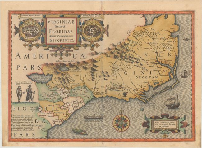
Auction 173, Lot 102
Subject: Colonial Southeast United States
Mercator/Hondius
Virginiae Item et Floridae Americae Provinciarum, Nova Descriptio, 1623
Size: 19.1 x 13.5 inches (48.5 x 34.3 cm)
Estimate: $1,800 - $2,100
A Seminal Map of the Southeast and Early American Cartography
Sold for: $1,300
Closed on 6/5/2019
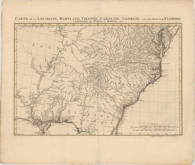
Auction 173, Lot 104
Subject: Colonial Southeast United States
Covens & Mortier
Carte de la Louisiane, Maryland, Virginie, Caroline, Georgie, avec une Partie de la Floride, 1758
Size: 23.3 x 15.4 inches (59.2 x 39.1 cm)
Estimate: $1,500 - $1,800
Covens & Mortier's Map of the Southeast Issued During the French and Indian War
Sold for: $850
Closed on 6/5/2019
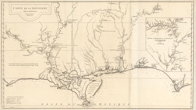
Auction 173, Lot 105
Subject: Colonial Southern United States
Anville, Jean Baptiste Bourguignon d'
Carte de la Louisiane par Le Sr. D'Anville Dressee en Mai 1732. Publiee en 1752., 1752
Size: 36.4 x 20.4 inches (92.5 x 51.8 cm)
Estimate: $1,600 - $2,000
An Early, Detailed Depiction of the Gulf Coast
Sold for: $1,000
Closed on 6/5/2019
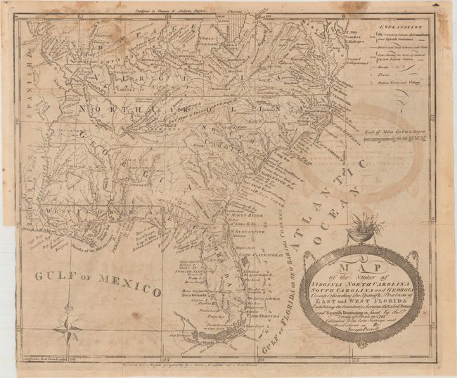
Auction 173, Lot 106
Subject: Southern United States
Purcell, Joseph
A Map of the States of Virginia North Carolina South Carolina and Georgia Comprehending the Spanish Provinces of East and West Florida..., 1793
Size: 14.8 x 12.4 inches (37.6 x 31.5 cm)
Estimate: $800 - $1,000
Second State of Purcell's Map Locating the Proposed State of Frankland
Sold for: $650
Closed on 6/5/2019
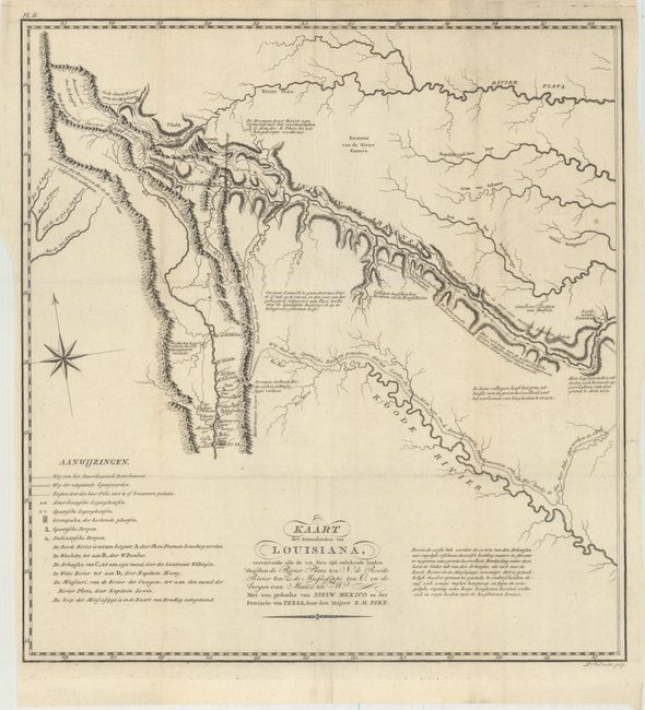
Auction 173, Lot 115
Subject: Southwestern United States
Pike, Zebulon
Kaart der Binnenlanden van Louisiana, Vervattende alle de tot dien tijd Onbekende Landen..., 1812
Size: 14.7 x 15.6 inches (37.3 x 39.6 cm)
Estimate: $1,800 - $2,200
A Cornerstone Map of Early Western Exploration
Sold for: $900
Closed on 6/5/2019
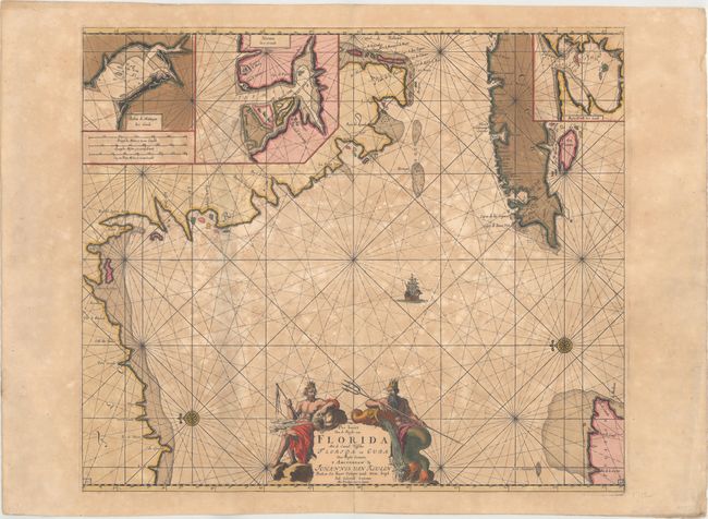
Auction 173, Lot 131
Subject: Florida & Cuba
Keulen, Johannes van
Pas Kaart van de Boght van Florida met de Canaal Tusschen Florida en Cuba, 1700
Size: 23.2 x 19.9 inches (58.9 x 50.5 cm)
Estimate: $2,400 - $3,000
One of the First Charts of the Florida Gulf Coast in Full Contemporary Color
Sold for: $1,000
Closed on 6/5/2019
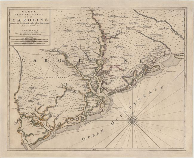
Auction 173, Lot 158
Subject: Colonial South Carolina, Charleston
Sanson/Mortier
Carte Particuliere de la Caroline Dressee sur les Memoires le Plus Nouveaux, 1700
Size: 23.4 x 18.9 inches (59.4 x 48 cm)
Estimate: $3,500 - $4,250
Foundation Map of South Carolina - First State
Unsold
Closed on 6/5/2019
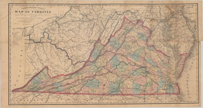
Auction 173, Lot 168
Subject: Virginia, Civil War Reconstruction
Maury, M. F.
Virginia Military Institute Map of Virginia Compiled Chiefly from C.L. Ludwig's Map, and from Other More Recent Data..., 1868
Size: 35.2 x 18.8 inches (89.4 x 47.8 cm)
Estimate: $1,200 - $1,500
Third Edition of the Bucholtz-Ludwig Map of 1858
Sold for: $800
Closed on 6/5/2019
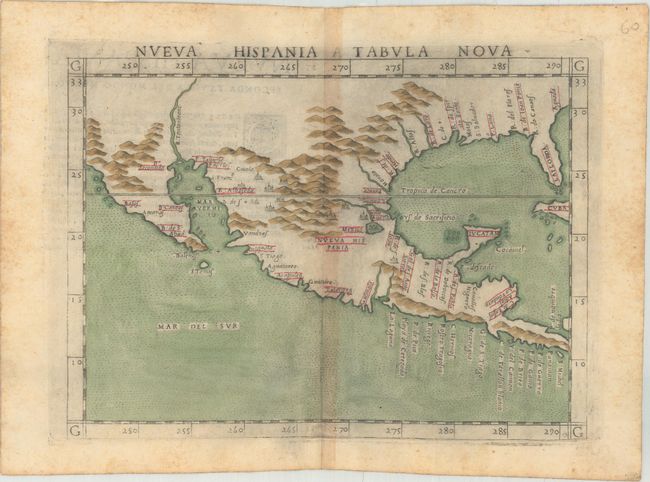
Auction 173, Lot 172
Subject: Southern United States & Mexico
Ruscelli, Girolamo
Nueva Hispania Tabula Nova, 1574
Size: 9.6 x 7.1 inches (24.4 x 18 cm)
Estimate: $1,100 - $1,400
A Foundation Map for the American Southwest
Sold for: $800
Closed on 6/5/2019
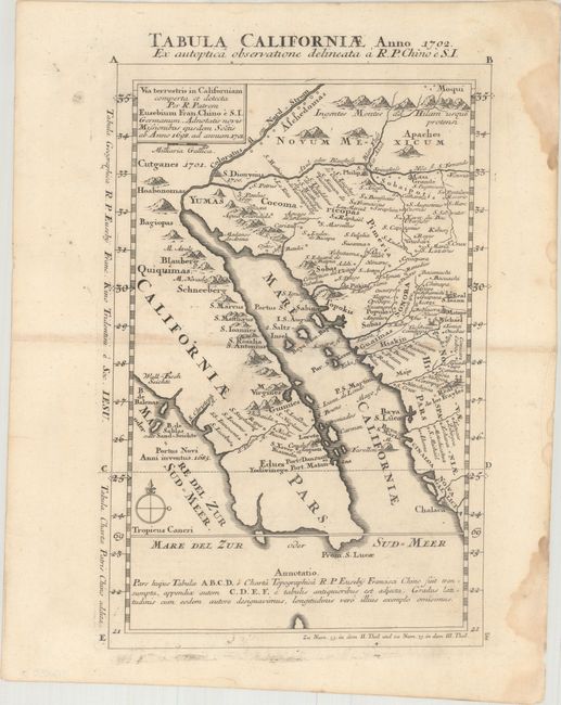
Auction 173, Lot 173
Subject: Southwestern United States & Mexico
Kino, Eusebio Francisco, SJ
Tabula Californiae, Anno 1702. Ex Autoptica Observatione Delineata a R.P. Chino e S.I., 1702
Size: 9.2 x 13.6 inches (23.4 x 34.5 cm)
Estimate: $2,000 - $2,400
Kino's Scarce Second Map of Lower California
Sold for: $1,500
Closed on 6/5/2019
18 lots