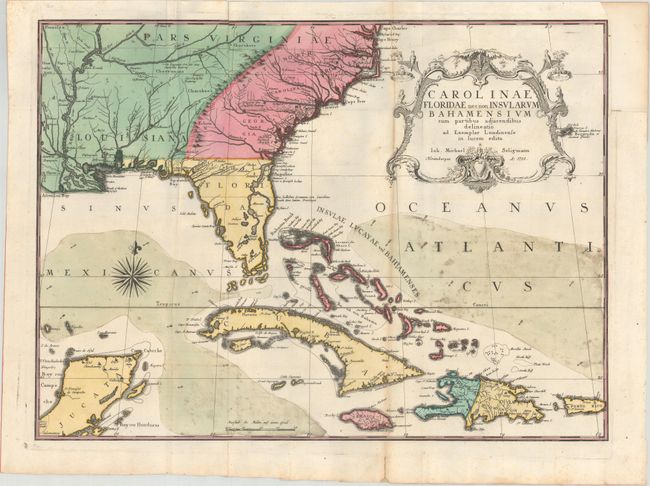
Subject: Colonial Southeast United States, Bahamas & Greater Antilles
Period: 1755 (dated)
Publication: Sammlung Verschiedener Auslandischer und Seltener Vogel...
Color: Hand Color
Size:
23 x 16.8 inches
58.4 x 42.7 cm
This handsome map extends to include the Bahamas, Cuba, Jamaica, Hispaniola, Puerto Rico and the Yucatan. The map is from the German edition of Mark Catesby's Natural History of Carolina, a seminal work on American flora and fauna. The map depicts the southeastern United States as far west as the Mississippi River and is colored to show the British Colonies in pink, French possessions in green and the regions controlled by Spain in yellow. Catesby drew on several important maps for the content, including the manuscript of Captain John Barnwell (1722) that incorporates several details not found on earlier printed maps. He also used Popple's great 20-sheet map as seen by the river configuration in Georgia and the dotted trail connecting Fort Argyle to Combahee River.
References: Cumming (SE) #292; cf. Schwartz & Ehrenberg pp. 151-152.
Condition: B
A sharp, dark impression, issued folding with toning along one of the folds and some mildew stains in the portions of the ocean with wash color. A short fold separation in the bottom blank margin and another extending 3.5" into the image at top left have been closed on verso with non-archival tape. A 1" binding tear at top right has been closed on verso with archival material, and the binding trim has been replaced with old paper.