Catalog Archive
Auction 173, Lot 168

Third Edition of the Bucholtz-Ludwig Map of 1858

"Virginia Military Institute Map of Virginia Compiled Chiefly from C.L. Ludwig's Map, and from Other More Recent Data...", Maury, M. F.

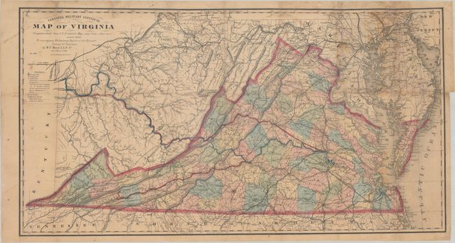
Subject: Virginia, Civil War Reconstruction

Period: 1868 (dated)

Publication: Physical Survey of Virginia...

Color: Hand Color

Size:
35.2 x 18.8 inches
89.4 x 47.8 cm
Download High Resolution Image
(or just click on image to launch the Zoom viewer)

This detailed map of the state was issued shortly after the conclusion of the Civil War and, according to Bill Wooldridge's excellent article in the Portolan, is the third edition of the Bucholtz-Ludwig map of 1858. It is the same width as the original Bucholtz map but about 5" shorter, and a new title imprint has replaced the old table of railroads. In 1868 General Francis Smith, Superintendent of the Virginia Military Institute, convinced Maury to return to Virginia (from England) to become a Physics professor and produce a "Physical Survey of Virginia." The survey was intended to aid in Virginia's recovery from the Civil War with the goal of developing "the physical resources of the State, to make known its geography, and to point out the great commercial advantages which naturally arise from its situation with regard to the sea and the interior." While the original goal of both Smith and Maury was to carry out brand new surveys and triangulations, the reality was that Maury was only given 6 months to complete the task. Given the tight timeline, Maury elected to use Ludwig's map with some modifications, and gives credit to Ludwig as the engraver.

Cartographically, the map extends west through the unnamed West Virginia to the Ohio River with Virginia counties highlighted in hand color. A key at left identifies towns, cities, completed railroads, proposed railroads, canals, hot springs, and more. Of particular interest in this example is the erroneous state border that locates Alleghany, Bath and Highland counties in West Virginia that was accidentally held over from Ludwig's earlier map. While Maury corrects this to a degree by coloring these counties to be part of Virginia, the engraved state border is clearly visible on the eastern edge of these counties. Also of interest is the use of color (not defined in the key) to highlight specific railroads and canals of importance including a rail line to the coal riches of southwest Virginia and both a potential railroad and canal extending to the Ohio River. Completing a communication with the Ohio River would have opened up a new trade route between the Mississippi River and Atlantic Ocean, and resulted in tremendous benefit to the state's economy.

Matthew Fontaine Maury (1806-73) was Superintendent of the U.S. Naval Observatory from 1842-1861. In 1855 he published his Physical Geography of the Sea, which was the first comprehensive book on oceanography. Prior to his role at VMI (1868-73), Maury was a Commander in the Confederate Navy.

There has been only one dealer listing and no auction records for this map in the last 35 years. Click here for an example of the 1858 Bucholtz-Ludwig map offered in a previous auction.

References: Wooldridge (Portolan - Spring 2007) pp. 26-39; Stephenson & McKee, p. 268; Phillips (Maps) p. 990.

Condition: B

Issued folding and now flattened with expert repairs on verso to numerous small fold separations at top and right. Four small areas of loss at top right have been professionally reinstated in facsimile. There is light staining and foxing, and the map has been fully encapsulated in Mylar.

Estimate: $1,200 - $1,500

Sold for: $800

Closed on 6/5/2019

Archived